Part I
Chapter 1
Ancient Greece encompassed the southern part of the Balkan peninsula and the Peloponnese, as well as the numerous islands of the Aegean Sea and the more remote islands of Crete and Cyprus. Moreover, Greek cities were founded along the adjacent coast of Asia Minor, in modern Turkey, during the early part of the first millennium BC. Finally, during the colonisation period starting in the second half of the eighth century BC, Greek settlements sprang up all round the Mediterranean and to some extent even on the Black Sea. This far-flung urban construction constituted the most important transformation of the landscape in the ancient world, and the one with the most lasting consequences.
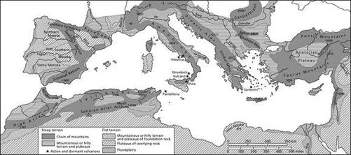
Both geographical and political factors were decisive in the emergence of this Greek world. The landscape of Greece itself, with its small-scale structures, has only a few broad coastal strips and fertile plains, but many promontories and offshore islands. The resulting landscape pockets are separated from one another by numerous mountain ranges and bays which cut deep into the coastline, so that fragmentation is the most striking characteristic (Fig. 1). Nevertheless, in the valleys and small plains conducive to settlement and farming, humus-rich areas were formed from the soil washed down from the mountains. Politically, the decisive factor was that after the decline of the great castles and palaces such as Mycenae, Tiryns and Pylos around 1200 BC, the fall in population in the ensuing period and the beginning of settlement activity in the early years of the first millennium BC, there was no threat from the outside, kingship had disappeared and an autonomous development of small communities was able to emerge. There were very few common, supraregional tasks which had to be addressed.
Fig. 1 Major terrain types in the Mediterranean area.
Despite the early voyages of discovery, commercial relations and the founding of cities, geographical knowledge remained modest until Hellenistic times (336–30 BC). The earth was thought to be flat, surrounded by the Okeanos, the world-embracing ocean, and subdivided by seas and rivers. The natural philosopher Anaximander of Miletus drew the first map of the world in the sixth century BC; it was improved upon by Hecataeus, who added a description of the earth (Periodos ges). Around the time of the transition to the classical era, the idea that the world was round first emerged, and in the third century BC Eratosthenes was even able to attempt a measurement of it, although that did not put the notion that it was flat to rest. After 326 BC, when the Macedonian king Alexander the Great reached the Indus on his campaign of conquest in Asia, and was there faced with the realisation that the end of the inhabited world was not discernible, the ‘conquerability’ of the entire earth was seriously called into question – even if the Romans would later repeatedly consider that prospect.
The ‘polis’ and the ‘chora’: the city and its countryside
The form of community and state organisation characteristic of the Greek world was what we describe as the polis, or city state. Polis originally meant castle or fortress, and by extension also referred to the settlement under the protection of that fortification. Hence,polis meant both the city and the city state, the community of citizens, a community united around a municipal centre with its surrounding countryside (chora), managing itself autonomously and protecting the landed property of its members. There thus emerged a pattern of fortified centres and unfortified rural settlements near to cultivated fields; densely populated landscapes concentrated administrative, religious and political functions in a municipal centre. In the case of Athens, interior settlement has been observed in thepolis territory, with a number of villages being established in the countryside surrounding the city.1 Despite the dominance of a centre, no polarisation arose between town and country, as the city's residents too were often farmers. Altogether, we can assume some 700 poleis in the Greek world. A polis often had only several hundred citizens, although in the case of Athens, approximately 30,000 citizens enjoyed full political rights; beyond that, the city was home to an equal number of metics – foreign residents without Athenian citizenship rights – and slaves. Since these figures refer only to adult males, the full population of Athens was about 50,000, with around 250,000 as a whole in the region of Attica (there was no legal urban–rural distinction).
The polis first arose in the ninth or eighth century BC; the first literary testimonials to it are from Homer and Hesiod around 700 BC. The planning of the settlements was oriented around a centre, the agora, which served as a market and meeting place, with public buildings. Temples are already provable in the tenth century BC, as in Aigeira in the northern Peloponnese. Central cults emerged, connecting the newly established communities. For political purposes, the citizens assembled on the agorai, which were ever more frequently used. In Athens the municipal centre apparently initially lay to the north-east of the Acropolis. Further west, in the area of the future agora, which first had to be drained, were graves dating back to the eighth century BC. Thereafter, a cemetery was established outside the settlement (the Kerameikos; see Fig. 7 below).
A network of long-distance routes already existed at the time of the Greek poleis, that is, not merely regional roads or processional ways to such shrines as Eleusis or Delphi. These consisted primarily of footpaths or single-track roads for wagon traffic, which have particularly been ascertained in the Peloponnese.2 Strabo (5.3.8) generally tells of unpaved roads without drainage ditches. However, this deficiency hardly impeded local trade or export-oriented large-scale production. A lively trade existed even in early times, for the sea especially provided regular connections between particular regions and remote areas.
The era of colonisation
The Greek settlement had considerable implications for the landscape of southern Europe up to the area of the Black Sea. After the second half of the eighth century BC, the Greek world included areas all around the Mediterranean, so that the Greeks lived ‘like ants or frogs around a marsh’ (Plat. Phaid. 109b). The colonists were driven both by such crises as population growth, scarcity of farmland, the fragmentation of holdings and political disputes, and by the eagerness to discover new geographical areas and peoples. The Greeks called their colonies apoikiai, or ‘outward (re)settlements’, in which the settlers built new lives for themselves.
This was, however, only possible where there were both suitable vegetation and sufficient arable land to provide self-sufficiency. In areas dominated or controlled by major powers, only trading stations could be established. Such outposts were built in Syria (Al Mina, Tell Sukas), starting in the eighth century BC, and after the sixth century BC also in Egypt (Naukratis), Spain (Ampurias/Emporion) and Etruria (Spina, Pyrgoi), where primarily metals but also luxury goods were obtained. In the other direction, Greek products such as the bronze krater (‘vessel’) of Vix reached the Celts in Gaul and the adjacent areas of central Europe by way of the Phocaean colony of Massilia (Marseilles) at the mouth of the Rhone.
The colonisation often proceeded by first taking possession of an offshore island, from which the occupation of the mainland could then be carried out. This procedure could already be observed in the earliest colonies in southern Italy – such as Pithecusae on the island of Ischia, which preceded the founding of Cumae – and in Sicily, and also in North Africa (Cyrene in Libya). The towns were planned with a grid of right-angled streets, public squares and shrines. The urban builder Hippodamus of Miletus took up this form during the fifth century BC and attained fame for it, so that similar settlements arose in many places in the Greek world.
Unlike their modern counterparts, these colonies were independent of their mother cities, and were not subordinate to any imperial nation-state striving for control of large territories. Nonetheless, as in modern times, the colonies often exported raw materials and in return purchased such finished products as ceramic vessels and other artisans’ wares. Starting from the coastal settlements, land was occupied and raw materials extracted in the hinterland. In that way, new farmland was developed, parcelled out and cultivated, as can be seen in Metapontum in southern Italy.3 One negative result of the expansion of settlement activity in some places was the siltation of river mouths, such as that of the Meander at Miletus, particularly after the third century BC. However, cultivation and terracing could also check erosion, as the example of Olympia suggests (see below).
The Hellenistic kingdoms
With the conquests of Alexander the Great of Macedonia (336–323 BC), the area in which the Greeks settled and into which they carried their culture was enlarged considerably, for the entire Near East and Egypt came under the control of Macedonian kings. During his campaign against the Persians, Alexander had himself founded numerous cities, all the way to Baktria and Sogdia (modern Afghanistan and Tajikistan) and also on the Indus. Alexandria, which he built in Egypt, became the first multi-functional urban centre, serving political-administrative, military and economic purposes, and with the Museion, a research institute, became a new scientific centre. The offshore island of Pharos was connected with the mainland by an artificial causeway, so that two new harbour basins were created, and the landscape was changed extensively by technical means.
The great Hellenistic kingships of the Macedonians, Ptolemies and Seleucids which succeeded Alexander's reign promoted intensive internal colonising activities. Dozens of new towns which were Greek by culture sprang up in Asia Minor and in the Near East, in which Greek and Macedonian veterans were settled and given land grants in the surrounding countryside. Moreover, older settlements were refounded or Hellenised; here, the Greek gymnasium performed a key function as a seat of learning. The Seleucids established four important cities in Syria between the Mediterranean and Mesopotamia – Antioch, Apamea, and the ports of Seleucia Pieria and Laodicea – through which the fertile country along the Orontes was opened up and the northern Levantine coast kept under control. Originally, Seleucia on the Tigris near Babylon had been built as the royal residence and new capital of the Seleucid kingdom, but this was then transferred to Antioch on the Orontes. As a result, Antioch developed into a trade and cultural centre famous for its urban luxury, including water pipes and street lighting, and for the parks in the Grove of Apollo, in the suburb of Daphne.
Here the kings controlled not only the political, military and administrative structures; they also had vast landholdings in these enormous kingdoms. They demanded taxes in money and in kind from their subjects and tenants, so that intensive farming of the soil was initiated. In the Egyptian chora and in southern Syria, Ptolemaic soldiers were even issued landholdings, which they could lease out during campaigns, and later even sell.4 While some of the large Hellenistic empires soon began to crumble as a result of their many conflicts with one another, their era was only definitely brought to an end by the Romans, who subjugated the remaining kingdoms, Macedonia, Asia Minor, Syria and Egypt, as well as all of Greece, to their rule between 148 and 30 BC. This at the same time guaranteed settlement continuity and a gradual transition from Greek to Roman habits and legal structures.
Climate, coastlines and estuaries
As part of the newly developed art of investigation of natural history, the Greek philosopher Parmenides in the first half of the fifth century BC divided the earth into climatic zones for the first time, broadly distinguishing the scorched south, the temperate Mediterranean zone and the frigid north (Strab. 2.2.2). In the text attributed to him On Airs, Waters, and Places, the Greek physician Hippocrates of Kos (c. 460–370 BC) distinguished primarily between European and Asiatic climatic zones, which, he believed, had shaped the people quite differently. Aristotle in the fourth century BC enlarged the conventional number of four winds – Boreas, Zephyros, Euros and Notos – to eight, and initially occupied himself with meteorology. Later, his system was further differentiated (Plin.nat. 2.119ff.). Eratosthenes, who in Alexandria in the third century BC first measured the globe, distinguished seven climatic zones in parallel strips. This, however, hardly expanded geographical knowledge significantly, nor was climatic determinism questioned. No concrete effects of this teaching on settlement activity are apparent.
In addition to literary sources, scientific research into the climate and the landscape in antiquity is particularly important; of course, it has only been carried out for a few regions. Moreover, the human influence on the climate in antiquity is generally very difficult to discern. Overall, the climate apparently remained relatively constant after the ninth century BC, generally marked in the Mediterranean area by mild, rainy winters and hot, dry summers. A climatically colder and wetter period has been established between 850 and 600 BC, and again in the fourth century BC,5 primarily using carbon dating (the C14 curve) and Greenland ice-core analysis (the δ18O curve). In the second century BC a drier and warmer phase began,6 which is also attested by the agricultural writer Saserna (Colum. 1.1.4–5). Nevertheless, it is not clear whether this was continuous, or whether increased precipitation and a temperature drop should be assumed, as glacier growth may indicate.7 Ice-core data reveal that from AD 145 to 185 cold winters but also warm and damp summers predominated, until an overall deterioration finally began in the third century AD.8 In North Africa and the Iberian peninsula we can assume, for the period of the Roman occupation, a higher level of precipitation, which had a positive effect on economic development.
Even in the early phase (c. 50,000–10,000 BC), a filling of the river valleys with sediments can be ascertained all around the Mediterranean (‘Older Fill’); it can be attributed to climatic changes. Additional layers, starting in late antiquity at the latest and continuing to modern times (‘Younger Fill’), have also been deposited.9 These were in some cases already initiated substantially earlier, even in the Bronze Age, and may be due not only to climatic but also to anthropogenic causes.10 Despite numerous uncertainties, regional scientific studies should be able to clarify the differences in the effects caused by civilisation.
Four phases can be distinguished in the area of the Gulf of Taranto (Basilicata and Lucania), into which several parallel rivers flow. In a first phase beginning approximately 11,700 years ago, during the late Pleistocene and early Holocene, climatically caused deposits appear. During the next three phases, the Graeco-Roman period, the Middle Ages and the last two centuries, human influence becomes obvious in the sediments, indicating deforestation and agriculture.11 In the Argolis on the Peloponnese, river sediments show an early Bronze Age fill, with no further deposits until the Hellenistic period. This can be explained in part through terrace and dam construction, which was neglected again later.12 The settlement of Olympia was abandoned in the fifth centuryAD, and was gradually covered by a 10 m thick layer of sediment from the rivers Kladeos and Alpheios,13 although here anthropogenic influence was probably not the only cause.14
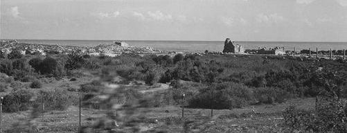
In addition to climatic and human impact, the sea level and the shorelines are also factors affecting the areas adjacent to the Mediterranean. In ancient times the sea level was approximately 1.5 to 2 m lower than it is today; it has been rising gradually with the melting of polar and other glaciers. Especially in the western Mediterranean, therefore, ancient shorelines are often now flooded; such cities as Larymna on the Gulf of Atalanti in central Greece and the part of Cyme in western Asia Minor which faced the sea are now under water.15 However, the rising of the sea level was also accompanied by horizontal coastal movement and increasing sedimentation of the rivers. The ports of Delos and the Libyan ports in Sabratha, Leptis Magna (Fig. 2) and Apollonia are all now silted up,16 as are Ostia, Sybaris and Metapontum. While Kenchreai, the eastern port of Corinth, was disappearing into the sea, Helike on the Gulf of Corinth was struck by an earthquake and tsunami in 373 BC, and possibly buried under the sediments of three rivers.
Fig. 2 Silted harbour of Leptis Magna, Libya.
Alluvia caused by humans and reinforced by the climate led to the widespread problem of the siltation of river mouths, as in the cases of the Nile, the Meander, the Achelous, the Po, the Tiber, the Rhone and the Ebro. The historian Thucydides (2.102) reported that the Achelous, separating the regions of Acarnania and Aetolia in western Greece, dumped a considerable amount of material in winter, and that some of the Echinades islands lying off its mouth had already been silted up. The Gulf of Thessalonika (Gulf of Therma) silted up between 500 BC and AD 100, so that only a small inland lake was left.17 Since there are no major rivers in Greece, it was the river mouths of Asia Minor, such as the Cayster (Ephesus) and the Meander (Miletus, Heraclea, Myus), which were affected most drastically by siltation.
Our main source for the mouth of the Meander at the Gulf of Latmos is Pausanias (second century AD, 7.2.10–11):
The people of Myus left their city on account of the following accident. A small inlet of the sea used to run into their land. This inlet the River Meander turned into a lake, by blocking up the entrance with mud. When the water, ceasing to be sea, became fresh, gnats in vast swarms bred in the lake until the inhabitants were forced to leave the city. They departed for Miletus, taking with them the images of the gods and their other movables, and on my visit I found nothing in Myus except a white marble temple of Dionysus.
(Loeb)
Though in the fifth century BC the port of Myus had still been used by warships (Hdt. 5.36), by the first century BC the city could be reached through the muddy water only by rowing boats, while Priene, to the north-west, was entirely silted up at a distance of 40 stadia (c. 7.5 km); further south, however, Heraclea was apparently still located on the sea coast (Strab. 12.8.17, 14.1.8, 10). By the first century AD the Meander was reported to have emptied into the sea 10 stadia (c. 1.85 km) from Miletus (Plin. nat. 5.113), so that the siltation had progressed at an average of approximately 2 km per century – considerably faster than siltation at the Cayster had done at Ephesus. By the fourth century AD, the ports of Miletus seem to have been entirely silted up, and later accessible only by way of the Meander, although the speed of siltation decreased considerably after the end of antiquity.18
1 Zimmermann 2004, 131.
2 Tausend 2006.
3 Mertens 2006, 332–3.
4 Cohen 1978, 53ff., 63ff.
5 Maise 1998, 219–20.
6 Lamb 1981; cf. Chapter 22, n. 2, below.
7 Patzelt 1994; Nenninger 2001, 98.
8 Klostermann 2008, 29–30.
9 Vita-Finzi 1969.
10 Wagstaff 1981.
11 Brückner 1983, 1986, 1990.
12 Van Andel et al. 1986, 1990.
13 Büdel 1981, 259ff.
14 Grove and Rackham 2001, 291ff.
15 Schäfer and Simon 1981, 29.
16 Trousset 1987, 137ff.
17 Eumorphopulos 1963; Bintliff 1981, 18.
18 Brückner 1997.