
Part I
Chapter 1
8 RECONNAISSANCE TECHNICAL SQUADRON (SAC)
UNITED STATES AIRFORCE
Westover Airforce Base
Massachusetts
6 July 1960
SUBJECT: Admiral Piri Reis World Map
To: Professor Charles H. Hapgood,
Keene College,
Keene, New Hampshire.
Dear Professor Hapgood,
Your request for evaluation of certain unusual features of the Piri Reis World Map of 1513 by this organization has been reviewed.
The claim that the lower part of the map portrays the Princess Martha Coast of Queen Maud Land Antarctica, and the Palmer Peninsula, is reasonable. We find this is the most logical and in all probability the correct interpretation of the map.
The geographical detail shown in the lower part of the map agrees very remarkably with the results of the seismic profile made across the top of the ice-cap by the Swedish-British Antarctic Expedition of 1949.
This indicates the coastline had been mapped before it was covered by the ice-cap.
The ice-cap in this region is now about a mile thick.
We have no idea how the data on this map can be reconciled with the supposed state of geographical knowledge in 1513.
HAROLD Z. OHLMEYER
Lt Colonel, USAF
Commander
Despite the deadpan language, Ohlmeyer’s letter1 is a bombshell. If Queen Maud Land was mapped before it was covered by ice, the original cartography must have been done an extraordinarily long time ago.
How long ago exactly?
Conventional wisdom has it that the Antarctic ice-cap, in its present extent and form, is millions of years old. On closer examination, this notion turns out to be seriously flawed – so seriously that we need not assume the map drawn by Admiral Piri Reis depicts Queen Maud Land as it looked millions of years in the past. The best recent evidence suggests that Queen Maud Land, and the neighbouring regions shown on the map, passed through a long ice-free period which may not have come completely to an end until about six thousand years ago.2 This evidence, which we shall touch upon again in the next chapter, liberates us from the burdensome task of explaining who (or what) had the technology to undertake an accurate geographical survey of Antarctica in, say, two million BC, long before our own species came into existence. By the same token, since map-making is a complex and civilized activity, it compels us to explain how such a task could have been accomplished even six thousand years ago, well before the development of the first true civilizations recognized by historians.
Ancient sources
In attempting that explanation it is worth reminding ourselves of the basic historical and geological facts:
1 The Piri Reis Map, which is a genuine document, not a hoax of any kind, was made at Constantinople in AD 1513.3
2 It focuses on the western coast of Africa, the eastern coast of South America and the northern coast of Antarctica.
3 Piri Reis could not have acquired his information on this latter region from contemporary explorers because Antarctica remained undiscovered until AD 1818,4 more than 300 years after he drew the map.
4 The ice-free coast of Queen Maud Land shown in the map is a colossal puzzle because the geological evidence confirms that the latest date it could have been surveyed and charted in an ice-free condition is 4000 BC.5
5 It is not possible to pinpoint the earliest date that such a task could have been accomplished, but it seems that the Queen Maud Land littoral may have remained in a stable, unglaciated condition for at least 9000 years before the spreading ice-cap swallowed it entirely.6
6 There is no civilization known to history that had the capacity or need to survey that coastline in the relevant period: between 13,000 BC and 4000 BC.7
In other words, the true enigma of this 1513 map is not so much its inclusion of a continent not discovered until 1818 but its portrayal of part of the coastline of that continent under ice-free conditions which came to an end 6000 years ago and have not since recurred.
How can this be explained? Piri Reis obligingly gives us the answer in a series of notes written in his own hand on the map itself. He tells us that he was not responsible for the original surveying and cartography. On the contrary, he admits that his role was merely that of compiler and copyist and that the map was derived from a large number of source maps.8 Some of these had been drawn by contemporary or near-contemporary explorers (including Christopher Columbus), who had by then reached South America and the Caribbean, but others were documents dating back to the fourth century BC or earlier.9
Piri Reis did not venture any suggestion as to the identity of the cartographers who had produced the earlier maps. In 1963, however, Professor Hapgood proposed a novel and thought-provoking solution to the problem. He argued that some of the source maps the admiral had made use of, in particular those said to date back to the fourth century BC, had themselves been based on even older sources, which in turn had been based on sources originating in the furthest antiquity. There was, he asserted, irrefutable evidence that the earth had been comprehensively mapped before 4000 BC by a hitherto unknown and undiscovered civilization which had achieved a high level of technological advancement:10
It appears [he concluded] that accurate information has been passed down from people to people. It appears that the charts must have originated with a people unknown and they were passed on, perhaps by the Minoans and the Phoenicians, who were, for a thousand years and more, the greatest sailors of the ancient world. We have evidence that they were collected and studied in the great library of Alexandria [Egypt] and that compilations of them were made by the geographers who worked there.11
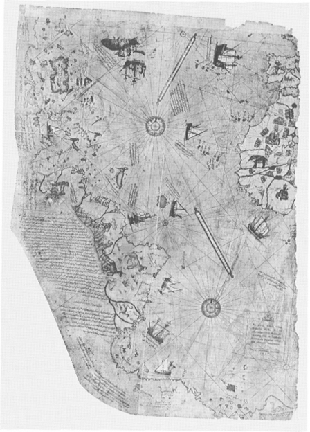
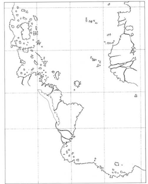
Left Piri Reis map (original). Above Redrawing to show detail.
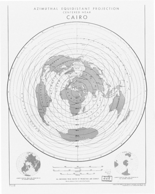
The US Airforce map shows the probable projection that governed the layout of the ancient Piri Reis map.
From Alexandria, according to Hapgood’s reconstruction, copies of these compilations and of some of the original source maps were transferred to other centres of learning – notably Constantinople. Finally, when Constantinople was seized by the Venetians during the Fourth Crusade in 1204, the maps began to find their way into the hands of European sailors and adventurers:
Most of these maps were of the Mediterranean and the Black Sea. But maps of other areas survived. These included maps of the Americas and maps of the Arctic and Antarctic Oceans. It becomes clear that the ancient voyagers travelled from pole to pole. Unbelievable as it may appear, the evidence nevertheless indicates that some ancient people explored Antarctica when its coasts were free of ice. It is clear, too, that they had an instrument of navigation for accurately determining longitudes that was far superior to anything possessed by the peoples of ancient, medieval or modern times until the second half of the eighteenth century.
This evidence of a lost technology will support and give credence to many of the other hypotheses that have been brought forward of a lost civilization in remote times. Scholars have been able to dismiss most of that evidence as mere myth, but here we have evidence that cannot be dismissed. The evidence requires that all the other evidence that has been brought forward in the past should be re-examined with an open mind.12
Despite a ringing endorsement from Albert Einstein (see below), and despite the later admission of John Wright, president of the American Geographical Society, that Hapgood had ‘posed hypotheses that cry aloud for further testing’, no further scientific research has ever been undertaken into these anomalous early maps. Moreover, far from being applauded for making a serious new contribution to the debate about the antiquity of human civilization, Hapgood until his death was cold-shouldered by the majority of his professional peers, who couched their discussion of his work in what has accurately been described as ‘thick and unwarranted sarcasm, selecting trivia and factors not subject to verification as the bases for condemnation, seeking in this way to avoid the basic issues’.13
A man ahead of his time
The late Charles Hapgood taught the history of science at Keene College, New Hampshire, USA. He wasn’t a geologist, or an ancient historian. It is possible, however, that future generations will remember him as the man whose work undermined the foundations of world history – and a large chunk of world geology as well.
Albert Einstein was among the first to realize this when he took the unprecedented step of contributing the foreword to a book Hapgood wrote in 1953, some years before he began his investigation of the Piri Reis Map:
I frequently receive communications from people who wish to consult me concerning their unpublished ideas [Einstein observed]. It goes without saying that these ideas are very seldom possessed of scientific validity. The very first communication, however, that I received from Mr Hapgood electrified me. His idea is original, of great simplicity, and – if it continues to prove itself – of great importance to everything that is related to the history of the earth’s surface.14
The ‘idea’ expressed in Hapgood’s 1953 book is a global geological theory which elegantly explains how and why large parts of Antarctica could have remained ice-free until 4000 BC, together with many other anomalies of earth science. In brief the argument is:
1 Antarctica was not always covered with ice and was at one time much warmer than it is today.
2 It was warm because it was not physically located at the South Pole in that period. Instead it was approximately 2000 miles farther north. This ‘would have put it outside the Antarctic Circle in a temperate or cold temperate climate’.15
3 The continent moved to its present position inside the Antarctic Circle as a result of a mechanism known as ‘earth-crust displacement’. This mechanism, in no sense to be confused with plate-tectonics or ‘continental drift’, is one whereby the lithosphere, the whole outer crust of the earth, ‘may be displaced at times, moving over the soft inner body, much as the skin of an orange, if it were loose, might shift over the inner part of the orange all in one piece’.16
4 During the envisaged southwards movement of Antarctica brought about by earth-crust displacement, the continent would gradually have grown colder, an ice-cap forming and remorselessly expanding over several thousands of years until it attained its present dimensions.’17
Further details of the evidence supporting these radical proposals are set out in Part VIII of this book. Orthodox geologists, however, remain reluctant to accept Hapgood’s theory (although none has succeeded in proving it incorrect). It raises many questions.
Of these by far the most important is: what conceivable mechanism would be able to exert sufficient thrust on the lithosphere to precipitate a phenomenon of such magnitude as a crustal displacement?
We have no better guide than Einstein to summarize Hapgood’s findings:
In a polar region there is continual deposition of ice, which is not symmetrically distributed about the pole. The earth’s rotation acts on these unsymmetrically deposited masses, and produces centrifugal momentum that is transmitted to the rigid crust of the earth. The constantly increasing centrifugal momentum produced in this way will, when it has reached a certain point, produce a movement of the earth’s crust over the rest of the earth’s body …’18
The Piri Reis Map seems to contain surprising collateral evidence in support of the thesis of a geologically recent glaciation of parts of Antarctica following a sudden southward displacement of the earth’s crust. Moreover since such a map could only have been drawn prior to 4000 BC, its implications for the history of human civilization are staggering. Prior to 4000 BC there are supposed to have been no civilizations at all.
At some risk of over-simplification, the academic consensus is broadly:
• Civilization first developed in the Fertile Crescent of the Middle East.
• This development began after 4000 BC, and culminated in the emergence of the earliest true civilizations (Sumer and Egypt) around 3000 BC, soon followed by the Indus Valley and China.
• About 1500 years later, civilization took off spontaneously and independently in the Americas.
• Since 3000 BC in the Old World (and about 1500 BC in the New) civilization has steadily ‘evolved’ in the direction of ever more refined, complex and productive forms.
• In consequence, and particularly by comparison with ourselves, all ancient civilizations (and all their works) are to be understood as essentially primitive (the Sumerian astronomers regarded the heavens with unscientific awe, and even the pyramids of Egypt were built by ‘technological primitives’).
The evidence of the Piri Reis Map appears to contradict all this.
Piri Reis and his sources
In his day, Piri Reis was a well-known figure; his historical identity is firmly established. An admiral in the navy of the Ottoman Turks, he was involved, often on the winning side, in numerous sea battles around the mid-sixteenth century. He was, in addition, considered an expert on the lands of the Mediterranean, and was the author of a famous sailing book, the Kitabi Bahriye, which provided a comprehensive description of the coasts, harbours, currents, shallows, landing places, bays and straits of the Aegean and Mediterranean Seas. Despite this illustrious career he fell foul of his masters and was beheaded in AD 1554 or 1555.19
The source maps Piri Reis used to draw up his 1513 map were in all probability lodged originally in the Imperial Library at Constantinople, to which the admiral is known to have enjoyed privileged access. Those sources (which may have been transferred or copied from even more ancient centres of learning) no longer exist, or, at any rate, have not been found. It was, however, in the library of the old Imperial Palace at Constantinople that the Piri Reis Map was rediscovered, painted on a gazelle skin and rolled up on a dusty shelf, as recently as 1929.20
Legacy of a lost civilization?
As the baffled Ohlmeyer admitted in his letter to Hapgood in 1960, the Piri Reis Map depicts the subglacial topography, the true profile of Queen Maud Land Antarctica beneath the ice. This profile remained completely hidden from view from 4000 BC (when the advancing ice sheet covered it) until it was revealed again as a result of the comprehensive seismic survey of Queen Maud Land carried out during 1949 by a joint British-Swedish scientific reconnaissance team.21
If Piri Reis had been the only cartographer with access to such anomalous information, it would be wrong to place any great weight on his map. At the most one might say, ‘Perhaps it is significant but, then again, perhaps it is just a coincidence.’ However, the Turkish admiral was by no means alone in the possession of seemingly impossible and inexplicable geographical knowledge. It would be futile to speculate further than Hapgood has already done as to what ‘underground stream’ could have carried and preserved such knowledge through the ages, transmitting fragments of it from culture to culture and from epoch to epoch. Whatever the mechanism, the fact is that a number of other cartographers seem to have been privy to the same curious secrets.
Is it possible that all these map-makers could have partaken, perhaps unknowingly, in the bountiful scientific legacy of a vanished civilization?