1
In the beginning, there was Troy and the Trojan War, made famous in European history by the two epic poems ascribed to Homer, the Iliad and the Odyssey. According to these poems, the Trojan War began when Helen, wife of Menelaus, king of Sparta, was abducted by Paris, a prince of Troy. The Iliad tells the story of the anger of the Greek warrior Achilles at Troy; the Odyssey recounts the adventures of Odysseus on his way home from Troy to the island of Ithaca. We see these two epics as largely fictional stories, but these and later memories of the Trojan War were of fundamental importance within antiquity and beyond. Greeks, Romans and others found their origins in the events surrounding the Trojan War, the founding acts of European history. Before looking at the later importance of the Trojan War, we need to understand the period in which these later tales are set, the period of the palaces in Crete and mainland Greece.
Heinrich Schliemann, born in 1822 in what is now northern Germany, had the beginnings of a classical education, but then moved into business, making money from various ventures, including the Californian gold rush. He later claimed that his father had inspired him with stories from Homer, and that at the age of 8 he had decided that one day he would excavate the site of Troy. These claims are probably part of the rich fantasy life Schliemann created for himself. But from his late thirties or early forties he was able to live on his accumulated wealth, and travelled widely for pleasure. In 1868, when he was 46, he visited Greece and Turkey, and the following year he published a book, Ithaka, the Peloponnese and Troy, in which he argued that Troy was to be found at Hisarlık, in north-west Turkey, near the mouth of the Dardanelles, contrary to the prevailing view which located Troy at the nearby site of Pınarbaşı. This argument was based in part on the work by a British archaeologist Frank Calvert, who had been excavating the site for the previous five years. Schliemann was determined to dig there himself, and in 1871, with the help of Calvert, he started the excavations that made him famous. Schliemann’s excavation techniques were poor, even by the standards of his time, as he simply dug through all the nine layers, including the layer near the bottom (Level II) that he believed to be Homer’s Troy, the city of King Priam. He is also accused of planting evidence, or at least of being extremely slack in his recording of the finds. But he did publish a book on the site, Troy and her Ruins, in 1875, and returned to dig there again on several other occasions. Despite all the criticisms levelled at Schliemann at the time and subsequently, his work, and his publicizing of it, did succeed in establishing Hisarlık in the modern imagination as Homer’s Troy. Schliemann also dug at other ‘Homeric’ sites. In 1876, he excavated in the Peloponnese at Mycenae, the home of Agamemnon, and on the island of Ithaca, off the north-west coast of Greece, at what he believed to be Odysseus’ palace.
Despite serious flaws in Schliemann’s arguments and evidence, he was responsible for two great achievements. First, chronological. In the early nineteenth century, most western Europeans assumed that the story of the Trojan War had no historical basis whatsoever, and was just a myth. Educated people still believed that the account of the world’s creation given in Genesis was literally true. In the seventeenth century Archbishop Ussher had determined that the world was created in 4004 BC, and there was no obvious place in his generally accepted account for complex societies in the Aegean earlier than the fifth century BC. It is hard for us today to imagine a view of the past in which time started so recently, a world without a human past stretching backwards for countless millennia: Homo sapiens is attested from about 130,000 years ago, and our more remote ancestor, Homo habilis, from about 2.5 million years ago. By the mid-nineteenth century geologists had already argued for a much longer history for the world. Schliemann revealed once and for all that there was an important ‘time before’ in the Aegean – a prehistoric period, lasting a thousand years or more, with its own complex societies, complete with large-scale monuments and long-distance connections. His second achievement was more technical. He came to realize that monuments alone were not enough for dating these newly discovered stretches of time, and that pottery, with its durability as a material matched to the changing styles of fabric, shape and pattern, could furnish a way of constructing an accurate relative chronology. Sequences of pottery, dated in relative terms, with some absolute pegs, are to this day the basis of archaeological chronologies.
Another great figure in the establishment of our present views about the early Aegean was Sir Arthur Evans, responsible for the excavation of Knossos on Crete. While Schliemann had been driven by his reading of Homer, Evans was in search of early forms of writing. Arthur Evans (1851–1941) was born into a well-to-do family; his father was an eminent archaeologist and collector. After taking a degree in modern history at Oxford, Evans travelled widely in northern and eastern Europe. In 1877 he became Balkan correspondent for the Manchester Guardian. When he married Margaret Freeman the following year, he and his wife set up house in Ragusa (modern Dubrovnik) on the Dalmatian coast. In 1883 they went to Greece, where they met Schliemann and heard about his work at Mycenae and other Mycenaean sites. When Evans became Keeper of the Ashmolean Museum (Oxford) in 1884 he announced that his goals were to broaden archaeology beyond the Classical period, and to collect and display a wider variety of ancient material.
It was not until 1894 that Evans made his momentous first visit to Crete. He had become interested in Aegean writing systems, through collecting engraved gems and seals for the Ashmolean. He visited the site of Knossos, and proposed to the local Cretan Archaeological Council that he would buy the land and excavate the site himself, hoping to discover there new evidence on early writing. Knossos was already known to be a rich archaeological site. In 1739 the British traveller Richard Pococke had seen the (scanty) standing remains, and in 1878 Minos Kalokairinos, from the nearby city of Herakleion, had dug trenches in what was later identified as the west wing of the palace, identifying the remains as those of the ancient Labyrinth, home of the Minotaur. Schliemann too had wanted to dig at Knossos and had made some soundings there in the 1880s. He had obtained an excavation permit from the Turkish authorities in Crete, but had not been able to make a suitable financial arrangement with the landowner.
In Evans’s case it was the political situation on Crete that prevented the start of his own work at Knossos. The Cretans were waging a War of Independence against the Ottoman Turks. The Turks left the island in 1898 and a new, autonomous Cretan government was established. By early 1900 Evans had acquired both the Knossos site and an excavation permit, and started work on 23 March. By this time he had already realized from the finds that had come his way that the culture of prehistoric Crete was different from that of the Mycenaean mainland, so different as to be ‘non-Hellenic’, in his eyes. He had therefore borrowed the name of Minos, son of Europa and Zeus and king of Crete, and created the term ‘Minoan’ to describe early Cretan culture. What Evans found at Knossos confirmed this view. The monumental structure, which he called the Palace of Minos, with its elegant architecture; the bright, exuberant wall-paintings and pottery; the ‘engraved tablets’ in a script that came to be called Linear B: all these were different from anything that had been seen before. The excavations lasted for five years (1900–1905), and the results were published in the six beautiful volumes of The Palace of Minos (1921–36).
It is easy to criticize Evans now, and indeed he was wrong about some important issues. He could never accept that the relationship between Minoan Crete and the Mycenaean mainland changed from Minoan cultural pre-eminence of the Aegean to Mycenaean pre-eminence on Crete, and he made mistakes in some of the restorations he undertook at Knossos, although restorations were necessary, not least because, most unusually, he had discovered multi-storey structures, which had to be made safe for further excavation and for visitors. Evans remains the major figure in the prehistoric archaeology of Crete, for his vision and for his determination to bring the results of his work into the public arena. He died heartbroken in 1941, in the mistaken belief that the German invaders of Crete had destroyed Knossos, but in fact the Germans had taken great care to protect the site. The pre-eminent historical importance of Knossos was firmly established throughout Europe.
Knossos and the rest of Crete in what is known as the Second Palace period, which began around 1750 BC, forms the starting point for this book. After a period of considerable prosperity and success for the island between the seventeenth and early fifteenth centuries, numerous sites were violently destroyed around 1430 BC. Around this time, the first Mycenaeans from the Greek mainland arrived on Crete. It would be too simplistic to see the coming of the Mycenaeans as a straightforward conquest of the island; rather, the new arrivals seem to have employed a combination of force, blending and collaboration with the existing Minoan elites. In the late fifteenth and fourteenth centuries, Knossos emerged as the main administrative centre of the island, with a new language of administration (Greek). The Mycenaean period on the mainland and on Crete was marked by further prosperity. But by 1100 BC, the end-point of this chapter, the palatial organization of the mainland and Crete had ceased to operate, and far-reaching social and political changes occurred. In the Second Palace period all roads had led to Knossos, but by 1100 BC that was no longer the case. The Aegean world had fragmented.
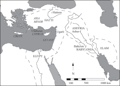
Map 1. The major Near Eastern states, c. 1220 BC.
We should not over-emphasize the importance of the palatial civilizations on Crete and in mainland Greece in the mid-second millennium BC. The Minoan and Mycenaean palace-states lay on the outer western fringe of a wider world of immeasurably more powerful and sophisticated Near Eastern states. Around 1500 BC the dominant power in the Near East was the kingdom of Egypt to the south. The Middle Kingdom (2116–1795 BC) had been replaced, after an Intermediate period (1795–1540 BC), by the New Kingdom (1550–1070 BC). The Middle Kingdom had been a period of stability in Egypt, with a secure frontier with Nubia (modern Ethiopia) to the south. During the Intermediate period, Egypt was ruled by a foreign dynasty, the Hyksos, with wide diplomatic andtrading connections, but exercising only fragile control over the whole country. With the expulsion of the Hyksos dynasty and the establishment of the New Kingdom c. 1550 BC, Egypt was reunified, extending from Nubia in the south to somewhere in Palestine to the north-east, more than 1,200 kilometres as the crow flies.
At the same time, the rest of the Near East was home to a number of competing states. During the turbulent years of the usurping Hyksos Dynasty in Egypt, central Asia Minor (modern Turkey) and Mesopotamia had also experienced a period of disruption and anarchy. Over three generations, starting around 1590 BC, urbanism had declined to its lowest level for 1,500 years. Human society was reduced to small, insecure settlements, with little or no broader organization. Out of this power-vacuum, from around 1500BConwards, there eventually emerged three major and relatively stable states. In Lower Mesopotamia, the Kassites succeeded in taking over Babylonia, the area of the lower Euphrates and Tigris rivers. Their extraordinarily long-lived dynasty ruled this area for some 400 years. In Upper Mesopotamia, an Assyrian kingdom emerged by 1400 BC. The Assyrians, originally a small principality centred on the city of Ashur (covering some 50 hectares), gradually built themselves up into a major Near Eastern superpower. The Assyrian state encroached on the Kassite kingdom to its south, and spread far to the north and west (some 700 kilometres north–south at its greatest extent). Finally, the old Hittite state reasserted its power in central Anatolia, entering a new phase of prosperity from around 1420 to 1200 BC, centred on its huge capital Hattusa (near modern Boğazköy), in north-central Anatolia. During this period the site was enlarged to cover 180 hectares, enclosed within monumental walls; palace complexes were built; and a special religious area was established in the upper city, with no fewer than thirty temples. From here the Hittite state controlled central Anatolia, and by around 1220 BC it had come to dominate a vast area, stretching from the Aegean coast of Anatolia in the west, towards an eastern border with the Assyrian kingdom on the Euphrates, and a southern border with Egypt in Palestine (some 1,000 kilometres east–west and north–south). It was one of the major players in the Near East in the second half of the second millennium, and had active diplomatic relations with the Aegean world.
These great Near Eastern empires of the second half of the second millennium BC shared many modern-looking institutions. Egypt, Babylonia and Assyria were territorial states, ruled from a centre. Egypt had been a territorial state for the past 1,500 years, but in Babylonia and Assyria, formerly independent cities lost their autonomy and formed parts of the new, wider state. By contrast, the Hittite kingdom was based more on the loyalty of vassal princes than on the wholesale incorporation of dependent cities. The ruling dynasties legitimated their positions through claims to historical precedent, and through construction of dynastic lineages. The states formed part of a common international system, and engaged in extensive diplomatic and trading connections with each other. For example, there survive copies of 350 letters sent between the Egyptian pharaoh Akhenaten (1353–1335 BC) and rulers outside Egypt (the so-called Amarna Letters). Most were sent by Akhenaten to his vassals in Syria-Palestine, but about forty were sent to or were received from rulers whom he treated as his peers, the ‘Great Kings’, who addressed each other as ‘brothers’. These ‘Great Kings’ included the rulers of Babylonia, Assyria and the Hittites, as well as other, lesser states whose favour the Egyptians required. Diplomacy included, when necessary, treaties between the different principalities, which spelled out in precise detail the boundaries between them. The internal workings of the states were highly centralized, with a very strong focus on the king as the central symbol of the state. The populations owed service to the king, in the form of taxes (for example, flocks, grain or silver) and labour (for public works or military service). In the Assyrian kingdom, the laws regulated many aspects of private life. In specifying, for example, the penalties which could legally be exacted of an adulterous wife and her lover, the laws created a communal framework which sought to control private vendettas. In comparison to these advanced states of the Near East, the Mycenaean and Minoan palatial societies of the Aegean were pretty small players.
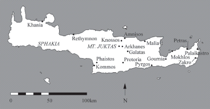
Map 2. Crete in the Second Palace period. The possible palaces are: Arkhanes; Galatas; Khania; Knossos; Kommos?; Malia; Palaikastro?; Petras, Phaistos; Protoria?; Rethymnon?; Zakro.
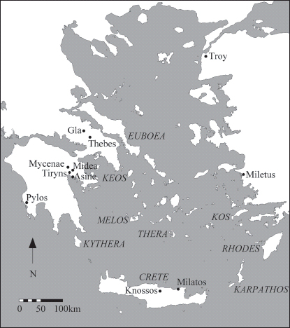
The Aegean world consists of Crete in the south, the Greek mainland up at least as far as Volos (in ancient Thessaly), and some of the southern Aegean islands. The island of Crete was dominated by a series of at least seven palaces. Knossos, excavated by Evans, is the most famous. It and Phaistos were indeed the two largest ones, but ten other palaces, all marked on Map 2, are known or conjectured. The list depends on the precise requirements for qualification as a palace.
Minos and Atlantis
Evans’s excavation of Knossos generated widespread interest in Minos. Evans himself argued that his work demonstrated the substantial truth of later Greek myth: Minos was a real person, whose palace was the Labyrinth of later myth, and whose sport of bull-leaping was the origin of the Minotaur story. One scholar in The Times of 1909 brought in Plato’s account of the lost kingdom of Atlantis, a mighty power in the Atlantic that made an unsuccessful expedition against Europe and Asia, only to be overwhelmed by natural disaster and sink into the waves. He argued that this legend was based on misunderstood Egyptian records of Minoan Crete. This type of argument has proved distressingly appealing to subsequent searchers for Atlantis: more recent archaeologists have attempted to link Atlantis with the ending of Minoan power, and the eruption of the Santorini volcano (for the redating of this eruption, see below, p. 27), and have even placed Atlantis at Troy. More recently, in 2004 Atlantis was ‘discovered’ off Cyprus, and in 2009, thanks to Google Earth, in the Atlantic off the west coast of Africa. The ordinary reader of Plato finds these repeated attempts to uncover ‘the truth’ behind Plato’s quite casual little story very odd.
Partly as a result of the excavation of Knossos, twentieth-century artists drew much inspiration from Cretan myths, treating old themes in a distinctively modern fashion. For example, in 1919–20 images of Europa and the bull by the German artist Lovis Corinth explored the then topical theme of the sexual awakening of the young girl. Other Cretan myths also proved fertile for artists. During the 1930s Pablo Picasso became obsessed with ideas of the Minotaur, stimulated in part by Spanish bullfighting, but also by the bullfighting fresco found at Knossos. Picasso went on to explore the themes of sexuality and violent death in a series of drawings and prints, including Minotauromachie (1935), regarded by some as the greatest graphic work of the twentieth century.
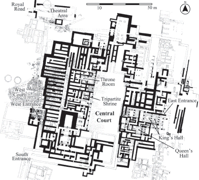
Figure 1. Plan of palace of Knossos in the mid-second millennium BC.
The site of Knossos lies some 5 kilometres from the north coast of Crete, south-east of modern Herakleion. The palace of the mid-second millennium BC had important predecessors on the same site. There had been significant settlement here during the third millennium BC, including a substantial structure on the same alignment as that of the later palaces. The First Palace, a large monumental complex, was built soon after 1900 BC, but destroyed by an earthquake c. 1700 BC. The Second Palace was built c. 1700 BC, on much the same lines as the First Palace, but in its turn was destroyed c. 1430 BC (see Figure 1). It was much used as the setting for ritual activities, by both women and men. These activities probably included the performance of bull-leaping, a ritual of great importance to the palace. The palace was approached from the north-west, via a stepped structure which may have been used to receive visitors, into the West Court, facing the west façade of the palace. From here a complex of corridors, with lavish frescos, led to the Central Court. This court was a large open area (50 × 25 metres), used for ceremonial purposes. Courts of this kind are defining characteristics of all the Cretan palaces. An antechamber off the Central Court led to the Throne Room; nearby was a shrine (the Tripartite Shrine), and two pillar crypts, small dark rooms believed to have ritual significance (Plate 1).
The residential quarter was set in the south-east part of the palace, with clever architectural features to maximize indirect light and air, and indoor plumbing (see Figure 2). Evans, the excavator of the site, thought that women and men lived separately: he assigned a larger set of rooms to men, the King’s Hall, and a smaller set to women, the Queen’s Hall. Evans’s assumptions about gender survive in the modern names for these rooms, but there is no evidence for segregated living quarters. Indeed, it may be that this whole area, like that to the west of the Central Court, was used for ceremonial purposes. The palace also had substantial storerooms, with huge storage jars to hold wine or olive oil, and a workshop for the production of luxury vessels that were made from stone imported from the Greek mainland. In the Second Palace period, the palace was surrounded by clusters of separate residential buildings. Overall, the settlement surrounding the palace covered about 67 hectares. The houses varied in size and complexity, but the grandest ones reproduced a number of architectural features seen in the palace itself.
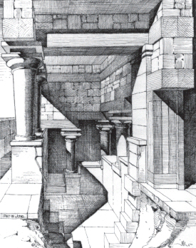
Figure 2. Restoration drawing of part of the Palace of Knossos, by Piet de Jong.
The ten or so palaces on Crete in the middle of the second millennium BC formed a network of centres, covering much of the island. They had common architectural features, and similar functions. Though the other palaces are smaller than Knossos and Phaistos, it seems that the states were more or less equal. They transferred goods between each other, and presumably also interacted in other ways. Ranking below the palaces was a system of subordinate settlements, which imitated the palaces in various ways. The town at Gournia included a main building that in one phase partially enclosed the settlement’s main square, making it like a palatial central court. Throughout the island there were also numerous ‘villas’, free-standing buildings with architectural features derived from the palace repertoire. They are less sophisticated than the palaces, and lack even miniature central courts, but they share the palatial style of stone-cutting and room design. The ‘villas’ and palaces formed part of a single political and economic system.
This system, however, did not incorporate all parts of Crete. The palaces and ‘villas’ are concentrated in the central and eastern part of the island, with a westward extension along the north coast as far as Khania. The west and south-west parts seem not to have been within the orbit of the palaces’ organization of the production of goods. The region of modern Sphakia is a good example of this. Forming part of the south-western part of the island, due south of Khania, Sphakia had few reflections of the palaces. In the western and central parts of Sphakia, which are cut off from the north coast by the White Mountains, settlements were modest both in scale and in artefacts. Only in eastern Sphakia, where a large coastal plain was open to coastal connections from palaces in central Crete, were things different (Plate 19). Settlements were larger in scale, with some signs of the palatial architectural repertoire.
Map 3. The Aegean c. 1400 BC.
Palaces also developed on the Greek mainland, but at a rather later date than on Crete. There was a long process of evolution from scattered chiefdoms (common in the earlier second millennium BC) towards more centralized states. The architectural development of the palaces is poorly understood, but soon after 1400 BC palaces were in operation at Mycenae, Tiryns, Pylos and Thebes. The palaces acquired a standard pattern, rather different from that found on Crete. At Pylos, the best-preserved mainland palatial site, the palace was modest in size (less than half a hectare), but complex in organization (see Figure 3). The fourteenth-century palace at Pylos seems to have imitated Minoan palace architecture, but the surviving palace of 1300–1200 BC is quite different from the Cretan palaces. It was entered through an elaborate gateway, with perhaps a guardhouse on one side, and a records room on the other, to process incoming and outgoing goods. From there one could pass through one court and a vestibule into the so-called megaron. The megaron was a rectangular room with four columns surrounding a central, circular hearth, with a lantern or clerestory above, and a throne set against one wall. The megaron was one of the defining characteristics of the mainland palaces, also found in the earlier palaces at Mycenae and Tiryns. Decorated with splendid frescos, the megaron was the key setting for ceremonial. It was surrounded by pantries and storerooms. From the court, one could also reach a smaller version of the main megaron, with adjacent bedroom and bathroom. Communal feasts were probably held in two places: for the elite in the open area between the South-west and the main building, outside another megaron, and for ordinary people in the open area in front of the palace.
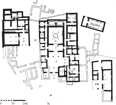
Figure 3. Plan of the palace at Pylos. The heavy lines indicate walls certainly attested; the hollow lines indicate walls not well preserved. 1: gateway; 2: guardhouse; 3: records rooms; 4: courtyard; 5: vestibule; 6: megaron; 7: pantries and storerooms; 8: smaller megaron; 9: megaron in South-west building; 10: court for feasting; 11: area for feasting.
The palaces at Mycenae, Tiryns and Thebes, on outcrops rising from the plain, were surrounded by elaborate fortifications (Plate 2). There were also other major fortified citadels at, for example, Midea, Asine and Gla. At Gla, an outcrop was surrounded by very thick walls, constructed of enormous stones. The huge walls enclosed a large area, some 24 hectares, making this the largest Mycenaean fortress. In the middle was a rectilinear enclosure (covering 4 hectares), with some widely separated buildings.
For us, the palaces on Crete and the Greek mainland in the middle of the second millennium BC mark the beginnings of Greek history. The Minoans and Mycenaeans, however, did not conceive themselves as part of a ‘young’ civilization; rather, they stood at the end of a long continuum, stretching far back into the prehistoric past. The lavish fresco decoration of the palace at Pylos is especially interesting. The megaron in the South-west building was decorated with scenes of warriors in Mycenaean armour defeating men dressed in animal skins. Though the armour (helmets, swords and greaves) is common in depictions of soldiers, the scenes seem not to be depictions of contemporary warfare. The boar’s-tusk helmets worn by some of the warriors were already old-fashioned in this period; as the Mycenaean warriors are all bare-chested and their opponents are not in realistic dress, the fighting is probably set in the remote, ‘heroic’ past. The megaron in the main palace is even more striking. The frescos on the walls of the megaron depict huge animals and human figures, with heraldic lions and griffins on either side of the throne; at one end of the megaron was an outdoor banqueting scene, with at least four men seated at tables, and, processing in from the vestibule to the megaron, a procession of men and women leading a bull to sacrifice. The dominant figure in the banqueting scene was a bard with a lyre, seated on a multi-coloured rock, possibly singing the heroic deeds of the past (Plate 3). The frescos of the Pylos megaron clearly had narrative significance to their original viewers. We cannot tell whether the frescos depict specific or generic scenes, but we can certainly imagine an audience listening to the bard’s songs about the Mycenaeans’ own heroic past.
The importance of the past in Mycenaean society emerges particularly clearly from the remarkable shaft graves of Grave Circle A at Mycenae (Plate 2). The graves were found by Schliemann in 1876, and their fantastic contents were proclaimed by him as typically Mycenaean. Five of the burials had gold face-masks, and incredibly rich grave goods. Overjoyed, Schliemann sent a telegram to the king of Greece: ‘With great joy I announce to Your Majesty that I have discovered the tombs which the tradition proclaimed by Pausanias indicates to be the graves of Agamemnon, Cassandra, Eurymedon and their companions, all slain at a banquet by Clytemnestra and her lover Aegisthus.’ In fact, it is now clear that these graves date to about 1700–1600 BC, and are thus much older than the surviving palace at Mycenae, and also much older than the conventional date of the Trojan War. But after 1300 BC, when the fortification wall was extended to the south-west, increasing the area of the acropolis by over a third, and the Lion Gate was built, Grave Circle A received special treatment. Other parts of the surrounding cemetery were built over, but the six shaft graves were preserved. A massive new retaining wall was constructed, perhaps on a foundation contemporary with the original graves, creating a much higher ground level. Round it was built an elaborate circular parapet, entered from near the new Lion Gate. Within it, some of the original tombstones were brought up to the new ground level, and reorientated. The rulers of Mycenae after 1300 BCwere presenting themselves as the rightful heirs of the rulers buried in the much older shaft graves.
The palaces on the Greek mainland stood at the centre of complex local systems. They were surrounded by substantial settlements, the size of small towns: at Pylos the associated settlement covered some 20 hectares, at Mycenae 32 hectares. As on Crete, the mainland palaces formed a multi-centred system. The separate palaces are similar to each other, but seemingly not dependent on any one single palace. Within each palace there was one supreme figure, the wanax, who presumably had overall authority in internal decision-making and in external diplomacy. Beneath him was the ‘leader of the people’, second in command to the wanax, and beneath him ‘nobles’, ‘companions’, ‘officials’, along with ‘mayors’ and ‘vice-mayors’ of the districts of the state. Some of these officials belonged to the central palace administration, others to the local administration out in the territory controlled by each individual palace. One set of these local officials was called basileis. Their authority perhaps rested on kinship, and predated the palace system; it is probably for this reason that the basileis (unlike the rest of these officials) survived the collapse of the palatial system. The basileis were involved in supervising local craft production. On one occasion, they were listed alongside the ‘leader of the people’, and so must be more than mere foremen, but the title rose in stature in the aftermath of the palatial system, coming to mean ‘noble’ and even ‘king’ (below, p. 49).
The political and military roles of this hierarchy are not clear to us, but the state certainly had considerable authority in economic matters. Unlike the Minoan palaces, the mainland palaces did not store goods centrally, but they did record and track agricultural goods produced elsewhere. They did not have much control over the production of agricultural staples, but they did oversee the production of some items, for example flax for the linen industry, and for these commodities they monitored the actual industrial processes. Much of the concern of the state was with internal redistribution of goods, but prestige goods like perfumed oil were widely exchanged abroad, probably in return for metals, spices and ivory, which the state needed to import. Though they are architecturally different from Cretan palaces, the mainland palaces performed the same functions: ceremonies, administration, recording of production of agricultural goods, storage of luxury items, and the manufacture of some products.
The palaces also had consequences for the extent to which the elite memorialized their ancestors. On the mainland, before the development of the palaces, local elites had displayed their wealth and power in the commemoration of their dead. The characteristic Mycenaean burial places were the ‘tholos’ and chamber tombs. Particularly impressive architecturally are the tholoi, mostly found in the Peloponnese, which consisted of long entrance-ways leading to circular, vaulted chambers rising to a point. The name tholos means ‘beehive’, since ancient beehives were of exactly this shape. A good example is the ‘Treasury of Atreus’ at Mycenae, part of the entrance façade of which is in the British Museum. In the palatial period, the number of tholoi in use declined, and they became concentrated round the palaces. It seems that members of the palatial elite chose to concentrate their resources in the vicinity of the palaces. On Crete in the Second Palace period there is very little evidence for burials at all, in contrast to the preceding and following periods. The palaces perhaps so dominated society that there was no room for memorializing the dead of individual families.
The relation between Crete and the mainland is not just a matter of similarities and differences. Around 1430 BC, many sites on Crete and also Minoan sites on the islands north of Crete were destroyed by fire, though not necessarily all at the same time. How to account for this phenomenon has been much debated. It used to be popular to claim that the eruption of the volcano on Santorini (ancient Thera), leading to a huge tsunami, caused these destructions. This claim was never plausible historically (why did damage on Crete not get repaired?), and some seismologists do not believe in the tsunami theory at all (how could the collapse of the north-west part of Santorini generate a tsunami travelling to the south-east?). In any case, the latest dating of the eruption of the volcano, based on radiocarbon analysis of a piece of buried olive wood, places it back in the late seventeenth century BC. The eruption of Santorini is now securely dated two hundred years before the destruction of the palaces.
The other main explanation for the destruction around 1430 BC used to be in terms of a takeover of the island by Mycenaean invaders from the mainland. Sites, or parts of sites, associated with the palatial administration seem to have been especially targeted. For example, at Pyrgos, the villa, but not the adjacent town, was burned. There are also some signs of terrible violence. At Mokhlos bodies were not buried, and at Knossos it seems that the flesh of dead children was eaten, perhaps because of siege conditions. We do not know for sure who was behind these destructions, but the current view is that an explanation in terms of Mycenaean invaders is too simple. Knossos under the Mycenaeans did come to dominate Crete for a time, but the Mycenaeans probably collaborated with, and intermarried with, local Minoan elites.
Knossos itself did not escape the general destruction at this time, but unlike other Minoan palaces, it was immediately rebuilt. The palace at Knossos soon became the main administrative centre on Crete for the Mycenaeans. The new palatial administration made use of at least four geographical regions, with a fifth linking Knossos to two local major sanctuary sites, to which we shall return. The four regions extended from at least Khania in the west to perhaps the western edge of the Lasithi plateau in eastern Crete. Within the areas controlled by Knossos, subsidiary regional centres, both palaces and villas, continued to exist. For example, Phaistos, once an independent palace, continues to be mentioned in the post-1430 documents from Knossos; however, to all appearances the Phaistos palace was no longer capable of operating independently. Despite some elements of continuity, Cretan culture and art was hugely disrupted after the takeover: the language of administration changed, as we shall see shortly; buildings centred on courts were no longer built; the characteristic architectural features of palace-style buildings ended; and a large range of luxury objects, for example relief frescos, stone bull’s-head drinking vessels, and three-dimensional objects in ivory, ceased to be produced. It was not until the thirteenth century (1300–1200 BC) that the dominance of the island by Knossos ended, and Minoan identity asserted itself once again.
The palaces on Crete were bigger than those on the Greek mainland, but both were much smaller than the contemporary Near Eastern palaces of the mid-second millennium BC. Compare Mycenae (palace of only 1 hectare within a citadel of nearly 4 hectares) and Knossos (palace of 2 hectares) with Hattusa (no less than 180 hectares within the fortifications). This fundamental difference of scale has significant implications for the degree of complexity of the Cretan and mainland palatial systems. Unlike the states in the Near East, they did not develop written law-codes, or employ writing in complex and varied contexts. But the Cretan and mainland palaces did use writing in certain restricted contexts.
Writing began on Crete just before and during the period of the First Palaces. The idea was probably derived from the Near East, but the forms used were local inventions. The first script, known as ‘Cretan hieroglyphic’ (misleadingly, because it bears no resemblance to Egyptian hieroglyphic), was used to record numbers of commodities. ‘Cretan hieroglyphic’ was limited geographically to the centres at Knossos and Malia, but another script, Linear A, developed in southern Crete in the period of the Second Palaces. It was used throughout the island and beyond. Linear A was a more complex script than ‘Cretan hieroglyphic’: it had more signs, more linear shapes (hence its name), a range of signs for syllables, things and numbers. It too was used to record commodities, both on clay tablets, seals and pottery, but it was also used in other contexts; for example, it was inscribed on religious objects to record palatial dedications. It is still not clear whether the scripts of ‘Cretan hieroglyphic’ and Linear A represented the same language, two different languages, or different dialects of the same language. Whatever language or languages these might have been, we are confident that they were not Greek.
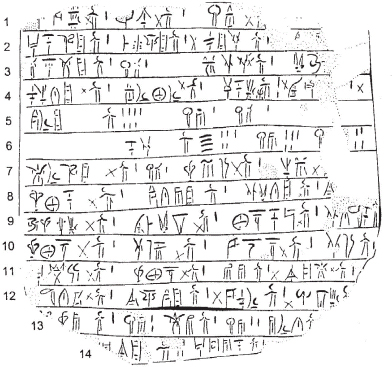
Figure 4. Linear B tablet from Knossos (now in the Ashmolean Museum, Oxford).
With the arrival of Mycenaeans on Crete, the system of writing changed. The script known as Linear B certainly originated on Crete, where it was used for exclusively administrative purposes. Far more Linear B than Linear A survives on Crete, mostly from Knossos, but also from Khania in the west. The Mycenaeans took the new script back with them to the Greek mainland. Clay tablets incised in Linear B are found in the palaces of Pylos, Tiryns, Mycenae and Thebes, and inscribed sealings at Midea. As on Crete, Linear B was used on the mainland solely for administrative purposes.
Linear B borrowed up to two-thirds of its signs from Linear A, but simplified them and added new ones. Its use was restricted to administrative purposes, and it was written almost entirely on clay, whether incised on tablets, or painted on transport jars. For example, a tablet from Knossos preserves parts of two lists of women working at Knossos (see Figure 4). Such lists were compiled in order to keep track of palace workers, and also to calculate the rations needed to feed them, and their dependent children. At the end of the first list, lines 4–6, we read the following:
Line 4: Woman from Phaistos X WOMAN 1. Philagra X WOMAN
1. *18–to-no, daughter WOMAN 2 X. wi-so WOMAN 1 X
Line 5: Women from e-ra WOMAN 7. Girl 1, Boy 1
Line 6: Total WOMAN 45 Girls 5, Boys 4.
The lists have a simple form: a name, the sign for WOMAN, and a number. The ‘X’s were added, very faintly, after the unfired clay tablet had dried, presumably as each woman or group of women was checked off by the palace official or scribe. The women are designated in various ways. Some are named individually, like Philagra. Others are named or grouped by their place of origin, like the woman from Phaistos (in south-central Crete), or the seven women from e-ra, located somewhere else in central Crete. Some women have young children with them, who were presumably too young to work. But one woman, *18–to-no, has a daughter, who was old enough to be counted as another adult woman (incidentally, ‘*18’ signifies a sign whose phonetic value has not yet been determined). The indented line 6 gives the total of the first list, forty-five women with their children, five girls and four boys. The partially preserved first list gives records for only twenty-odd women plus one girl and two boys, so it is clear that quite a big piece is missing from the top of the tablet. This meticulous form of listing people or commodities is typical of the Linear B tablets.
The Linear B script represented a different language from Linear A. Before the Second World War scholars could not read Linear B, but were united in their belief that it did not represent Greek; scholars are similarly united today in respect of Linear A, though this time on good grounds. But in 1952, an outsider to the discipline, Michael Ventris, succeeded in decoding Linear B, and proved that it did indeed represent the Greek language. For example, in the Linear B document just quoted, almost every word is known also in later Greek: ‘daughter’ (tu; abbreviation for later Greek thugater); ‘girl’ (ko-wa; later Greek: korē); ‘boy’ (ko-wo; later Greek: kouros). The Linear B tablets and painted transport jars are thus inscribed in Greek, more than four hundred years before the next surviving Greek writing.
The proof that the Mycenaeans on the mainland and on Crete used, and presumably spoke, Greek is a major link between this part of the second millennium BC and later Classical antiquity, though it is a real question how many Cretans actually learned to speak Greek during this period. But Linear B also demonstrates the differences between the palatial culture and what followed. Writing was very restricted in this period, and Linear B was more restricted in its use than Linear A. The script of Linear B was developed for list-making, and was not extended to write more discursive (let alone literary) texts. It was limited to the palaces and their bureaucratic administration. Because it was not deeply rooted in society, once the palaces ended, writing also disappeared.
In addition, Linear B was not a major medium of memory; as at Pylos and Mycenae, there were other ways of memorializing the past. Even in terms of list-making, the Linear B tablets were intended to have limited lives. The texts were written on clay tablets, which were then dried in the shade. They were kept for no more than a year, and then the clay could be recycled, which is why texts sometimes record carry-over information about debts from the previous year. Only in cases where these annual records were accidentally fired when the building storing them was destroyed do they survive. The Linear B tablets are therefore not parts of permanent archives. In this respect, they differ from the records of the Egyptians, Assyrians and Hittites. Those peoples did have permanent archives, with copies of royal correspondence, treaties and royal annals. They also displayed some texts publically in prominent locations, something that is entirely unknown in Mycenaean Crete or Greece.
The palaces of Crete and the Greek mainland, though they eventually came to be linked by common administrative practices and language, had developed along separate paths. There were some common practices, and in the end a broadly common identity, but also important differences between the two cultures. These differences are most clearly visible in the context of religious practices. On Crete during the Second Palace period rituals seem to have been organized by the palaces. In place of the monumental religious buildings found in the contemporary Near East, on Crete worship in this period centred on the palaces themselves and on peak sanctuaries. Several rooms in the palace at Knossos are said to have had ritual functions, but the arguments are speculative, and only two rooms, the so-called Tripartite Shrine (see Figure 5) and the Shrine of the Double Axes, were certainly used for cult activity. Much of the equipment used for cult was portable, which may mean that there were few permanently designated places for rituals, and hence little in the way of cult architecture. Peak sanctuaries and sacred caves were the other key component in the palatial religious system. The ‘peaks’, medium-level hilltops, were visible from each other, and formed a hierarchy of local and regional sanctuaries. For Knossos, the peak sanctuary on the lower of the two ridge-tops of Mt. Juktas was especially important. From the palace there was a fine view south to the peaks at the end of the valley in which Knossos lies. A Minoan road took worshippers the 6 kilometres along the valley up to Mt. Juktas. The site itself, approached via a grand ramp and surrounded by an impressive circuit wall, consisted of open terraces, an altar with offering tables, and modest subsidiary rooms built into the hillside. Another major cult site for Knossos was the cave of Eileithyia at Amnisos, 5 kilometres north-east of Knossos, which was the location for rituals and the making of offerings. The offerings at Amnisos, and at other caves, were much the same as those made at peak sanctuaries, which underlines the unity of the palatial religious system.
Figure 5. Knossos: reconstruction drawing of Tripartite Shrine on west side of Central Court.
The religious system on the mainland was rather different. The Mycenaeans borrowed some religious symbols from Crete, but did not have peak or cave sanctuaries, nor other external religious sites linked to palatial centres. At the palace centres, as on Crete, religious architecture was modest. At Mycenae, most of the cult centre, just south of Grave Circle A, was built immediately after the construction of the new fortification wall. It consisted of a complex of rooms, which are architecturally unremarkable, but with clear ritual features inside. For example, one shrine had in the centre a low rectangular dais, perhaps for libations (see Figure 6). On a raised platform at the far end of the room was a figurine, probably of a female deity, with a small offering table in front. To the left, a window offered a view of exposed natural rock, which must have been significant, linking the cult to this particular spot. To the right, a flight of steps led to an upper room, in which were stored numerous clay figures, probably representing worshippers. The whole complex, with its images of the goddess and her worshippers, has no parallels anywhere on Crete.
The gods worshipped on Crete and the mainland can be given names only when we have the evidence of Linear B, and only rarely is it possible to link the name of a deity to a particular place. The Linear B tablets give us names of deities familiar from later periods (such as Zeus, Hera, Poseidon and Dionysus), and they may have been important deities, but the tablets also give the names of other deities not known later, such as Potnia (‘Mistress’) and Diwia (the female version of Zeus). The group of deities worshipped varied from state to state. At Pylos, for example, one Linear B tablet records the religious rituals for a particular month, the location of the ceremonies, the offerings and personnel involved, and the deities who received the offerings. Overall, the tablet lists eight people, who may be ‘sacristans’, and thirteen gold vessels, probably heirloom drinking vessels used annually in the rituals; these rituals took place both in the main palatial religious area, and in four or five other sanctuaries outside Pylos. Potnia, worshipped in the main religious area, was the principal deity in the rituals on this tablet, but other deities were also worshipped: ‘The Lady of the Tresses’ and ‘The Cattle-like Lady’ in the sanctuary of Poseidon (a major deity at Pylos); Zeus, Hera, Drimios ‘son of Zeus’, and Hermes Areias; more minor deities like Iphimedeia and Diwia; and also lesser beings, ‘The Thrice-Hero’ and ‘The House-Master’. Pylos clearly had a highly complex pantheon, with deities of different importance, receiving a regular cycle of worship.
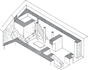
Figure 6. Isometric view of the shrine room at Mycenae, viewed from the south-west. The main room measures 5.1 × 4.3 metres.
It is tempting to stress the familiar names in this list, Zeus, Hera, Poseidon and Hermes, to point out that the religious system had both male and female deities, and male and female priests, and thus to claim a strong degree of continuity between the Bronze Age and the later Greek pantheon. But to succumb to this temptation would be a mistake. Point-for-point comparisons between Bronze Age and Classical religions ignore systemic differences between the religious systems of the two periods. The two religious systems are embedded in entirely different social and political settings, and even the similarity of some names does not imply that those deities have the same meanings in both periods. Talk of ‘continuity’ implies that deities were simply passed down the generations. This is to put things the wrong way round. Later generations took up names and practices that they knew of from the past, but adapted them to their own purposes, constructing their own new religious system for a changed world.
Some modern interpretations have emphasized the differences between the cultures of the Minoans and the Mycenaeans. Minoan civilization is often characterized as peaceful, without violent internal conflict, and the Minoans as carefree, happy and natural. By contrast, the Mycenaeans are regarded as dour and bellicose, their alleged invasion of Crete shattering the earlier peaceful idyll. Onto this schematic contrast another distinction is sometimes overlaid. The Minoans, for all their agreeable qualities, were foreign to us, not speaking Greek, while the Greek-speaking Mycenaeans are often seen as early Europeans. In fact, this polarity between the Minoans and the Mycenaeans is largely arbitrary, and the overlay of the European/non-European dichotomy deeply unhelpful. The Minoan language might be Indo-European (we do not know), and the Minoans and the Mycenaeans had much in common, especially in their external relations, overseas settlements, diplomatic contacts, and trading patterns. All three of these interrelated contexts show that we should not draw a simple contrast between Crete and the mainland.
Contacts between Crete and the islands to the north of Crete became intense in the First Palace period. Exchange between the two areas had considerable impact on the local populations of the Aegean islands, whose elites sought to emulate Cretan products. The trading exchanges were facilitated by the creation of overseas settlements of Minoans, principally on the islands of Thera, Melos and Keos. In the Second Palace period, the size and number of such settlements increased significantly. There were important sites to the north-west of Crete: on the island of Kythera, which had its own Minoan peak sanctuary, from which Crete is easily visible; on the islands north-east of Crete, Karpathos, Rhodes and Kos; and at Miletus on the coast of Asia Minor. In some cases, the previous population of the sites continued to live there, with a small admixture of Cretans; in others, the settlements were new creations in previously uninhabited parts of these long-settled regions. The site of Miletus is especially interesting. In the First Palace period, a handful of foreign merchants from Crete settled at an earlier town on the site of Miletus. In the Second Palace period, the nature of the Minoan presence at the site changed radically. The material culture of the site at Miletus in this period was predominantly Minoan: 85–95 per cent of the locally produced domestic pottery is of Minoan types. A sanctuary of Minoan type was constructed, with a mudbrick altar, and the Linear A script was in use, being incised on locally produced pottery before firing. It is clear that in this period many Minoans were living at the site of Miletus, in a colony with its own specifically Minoan organization. It was probably in this period that the site was first given the name ‘Miletus’; the Minoan settlers probably brought the name of the settlement with them from the town of Milatos on Crete.
This pattern of overseas settlements in the Aegean changed after the Mycenaean arrival in Crete. Minoan influence on the southern Aegean islands was replaced by a strong Mycenaean influence. At Miletus as at other similar sites, the Minoan period ended in destruction, and was replaced by a Mycenaean settlement. Most of the pottery, both imported and locally produced, follows Mycenaean patterns; even more significantly, houses and tombs were also of Mycenaean type, and there is evidence for Mycenaean-style rituals. A zone of Mycenaean settlements extended down the Anatolian coast south from Miletus, and into the offshore islands, especially Rhodes.
Both Crete and the Greek mainland had important diplomatic and other relations with contemporary Near Eastern states throughout the period covered in this chapter. In both the First and Second Palace periods, Crete was in close contact with Egypt. Wall-paintings of the second half of the sixteenth century BC from the royal palace at Tell el![]() Dab
Dab![]() a in the Nile Delta are very Minoan-looking, in style, technique and subject matter. The scenes show various Minoan motifs, including youths in Minoan dress, who may be engaged in the characteristic Cretan practice of bull-leaping. The importation of Minoan iconography points to close ties between Crete and Egypt at the start of the Egyptian New Kingdom period. In the fifteenth century, two noble tombs at Thebes, then the capital of Egypt, offer depictions of people called ‘Keftiu’ wearing Minoan dress and carrying metal or stone vessels of Minoan type, including a bull’s-head drinking cup, and models of whole bulls. These people must be Cretan ambassadors presenting lavish gifts to the Egyptians. It has even been suggested that in earlier paintings Keftiu look more Minoan, in later ones more Mycenaean.
a in the Nile Delta are very Minoan-looking, in style, technique and subject matter. The scenes show various Minoan motifs, including youths in Minoan dress, who may be engaged in the characteristic Cretan practice of bull-leaping. The importation of Minoan iconography points to close ties between Crete and Egypt at the start of the Egyptian New Kingdom period. In the fifteenth century, two noble tombs at Thebes, then the capital of Egypt, offer depictions of people called ‘Keftiu’ wearing Minoan dress and carrying metal or stone vessels of Minoan type, including a bull’s-head drinking cup, and models of whole bulls. These people must be Cretan ambassadors presenting lavish gifts to the Egyptians. It has even been suggested that in earlier paintings Keftiu look more Minoan, in later ones more Mycenaean.
The Hittites too had relations with the peoples of the Aegean. From the fifteenth century BC, the Hittite king was aware of ‘the Ahhiyawa’, a plural noun that referred to a neighbouring people in the west. The identification of the Ahhiyawa has been much disputed, but recently published Hittite texts now make it clear that the Ahhiyawa not only lay to the west of the Hittites, but were actually overseas. It is thus safe to identify them with the ‘Achaeans’, the Homeric name for the Greeks. In the thirteenth century, the Ahhiyawa began to assume some importance for the Hittite king. Hattusili III (1267–1237 BC) was attempting to restore order to the western part of Anatolia. A rebellious Hittite subject, Piyamaradu, had fled from Hattusili to Milawanda (Miletus), which was outside Hittite control, but under the indirect control of the king of the Ahhiyawa. Hattusili entered Milawanda in pursuit of Piyamaradu, asking the local ruler to hand the rebel over to him. But Piyamaradu fled by boat to take further refuge in Ahhiyawan territory, from which he continued to conduct raids on Hittite lands. Hattusili’s campaign had failed, and he wrote to the king of the Ahhiwaya, addressing him as brother, asking for his help in ending Piyamaradu’s activities. Given that we regard the Mycenaean states as a series of competing polities, it is striking that Hattusili regards the ruler of just one of them as the Ahhiyawa king. It is possible that the person concerned was the ruler of Thebes in central Greece (not to be confused with Thebes in Egypt). Thebes is known from Linear B tablets to have controlled not only the surrounding region of central Greece (the region later known as Boeotia), but also much of the large island of Euboea to the east. (This Boeotian connection may also account for a surprising concentration of Boeotian place names later attested in the area around Miletus.) The ruler of Thebes seems to have succeeded in promoting himself in the eyes of Hattusili as the Achaean king. Hattusili’s successor, Tudhaliya IV (1237–1209 BC), also campaigned in western Anatolia: he invaded the land of Milawanda, possibly destroying the settlement at Miletus, and installed an ally as overlord of this area. Tudhaliya referred to the kings whom he regarded as his peers: ‘the kings who are of equal rank to me, the king of Egypt, the king of Babylonia, the king of Assyria and the king of Ahhiyawa’. The scribe erased the reference to the king of Ahhiyawa, perhaps because of the Achaean king’s loss of authority following Tudhaliya’s actions in western Anatolia.
The common thread between Minoan and Mycenaean settlements overseas and the evidence for their relations with the Egyptians and Hittite kingdoms in the mid-second millennium BC is trade. From Crete, there were three main trade routes: to the north-west, via Kythera to the southern Peloponnese; to the north, via Thera, Melos and Keos, to the copper and silver mines in Attica; and to the north-east, via Karpathos and Rhodes, to Anatolia, and then eastwards to Cyprus and the Levant (the region of modern Syria, Lebanon, Israel and Jordan). It is no accident that the Minoan settlements discussed above were all located along these three routes. After the Mycenaeans arrived on Crete, Mycenaean trade took over from Minoan. The principal routes changed after 1300 BC, but the Mycenaeans, like the Minoans, had extensive interests in Anatolia and in Cyprus and the Levant.
The nature of trade in this period is seen most vividly in the evidence from a ship that foundered off Uluburun on the south coast of Anatolia not long before 1300 BC, and was excavated underwater from 1984 to 1994 (Plate 4). The ship, 15–16 metres long, was on its way west, having started in the Levant, perhaps at Ugarit, the largest international trading state in the region, sited just north of modern Lattakia in Syria. It was carrying an incredibly rich cargo: no fewer than 490 ingots of raw copper from Cyprus, weighing 10 tonnes, and about 120 ingots and fragments of tin, from somewhere else in the Near East, weighing another tonne. The copper ingots were of poor quality, being thin and brittle, but the metals would have produced about 11 tonnes of bronze. There were also 175 ingots of glass, in cobalt blue, turquoise and lavender, to be worked into precious objects; 24 logs of ebony from Egypt; ivory in the form of whole or part elephant tusks and hippopotamus teeth, ready to be carved, as well as a few items already carved; tortoise shells, to form the sound-boxes of lyres; ostrich eggshells; 149 jars perhaps from the region of Ugarit, one with glass beads, and some with olives, but most filled with a tonne of terebinth resin, from west of the Dead Sea, probably for burning as incense; and jewellery from the Ugarit region and from Egypt. In short, items originated from all over the Near East, from Cyprus, Egypt, Nubia, Syria and various parts of Mesopotamia. The cargo was probably being shipped at the request of an eastern ruler to the Aegean world. Tantalizingly, there were found two folded wooden writing tablets, of Near Eastern type, but no traces of what was written on the wax that was once inside them. Two Mycenaeans, identified by their swords and other personal items, were on board, probably to escort the cargo to one of the major Mycenaean palatial centres.
The hierarchy of goods in this snapshot of trade between the Levant and the Mycenaean world fits exactly the hierarchy of values in lists of goods exchanged between rulers within the Near East, as known from the Amarna Letters (described above), omitting only the top two goods, gold and silver. But the Mycenaeans were not passive recipients of largesse from their more powerful eastern neighbours. They imported raw materials, to be worked into objects in local style and with local meanings. In return, the Mycenaeans must have been offering other objects in exchange. We do not know for sure what these were, but silver was readily mined in Attica, and Crete was noted for its production of woollen textiles. The Egyptian wall-paintings mentioned above depict the Cretans wearing fine woollen dress, and there is a hint in Linear B tablets that some of the Cretan wool products, and also some of the perfumed oil from Pylos, were produced for export.
The Aegean states also traded to the west, with Sicily, Italy and Sardinia. There were no Minoan or Mycenaean settlements in this area, and trade seems to not to have been directed by the palaces, unlike in the Aegean itself. Instead, independent traders were probably responsible. With the expansion of Mycenaean interests, Mycenaean goods largely replaced Minoan exports in this area, as in the Aegean. But Crete did retain some links with the west. After 1200 BC pottery produced at Khania was traded to Italy and Sardinia and elsewhere, and, to judge from central-Italian-style pottery produced on Crete, some Italians had moved to Crete.
Troy, famous in later memory, lay on the fringes of Mycenaean external connections. The site excavated by Schliemann lies at least 5 kilometres from the modern coast, which makes it hard to think of it as a major maritime power. But studies of the topography of the peninsula where Troy is located have shown that the coastline in the third and second millennia BC was quite different from the present coastline, because the rivers Simois and Scamander have brought down so much silt. In the second millennium BC Troy was perfectly sited to control a large bay, which offered the only deepwater harbour for ships passing through the Dardanelles into the Black Sea. It had emerged by the second millennium as a major regional centre, dominating the north-west of Anatolia and the northern Aegean islands.
Troy’s material culture was west Anatolian, to judge from the style of house-building, cults located at gateways, and the one find of writing, a seal inscribed in Luwian, a widespread local language. Troy was, however, on the periphery of both the Aegean and Anatolian worlds. Some Mycenaean pottery of the fifteenth and fourteenth centuries BC was imported to Troy, probably from the eastern Aegean, and imitated locally, but only in very small quantities: around 1–2 per cent of the total amount of contemporary pottery at the site. Troy lay outside immediate Hittite control. King Muttawalli II (1295–1272 BC) had to send a Hittite expedition to restore order in a place called Wilusa, which seems to have been occupied by a rebel causing trouble to the Hittites and their vassal states. As it is clear that Wilusa lies in north-western Anatolia, and as Troy is the only major archaeological site in the region, Wilusa is probably to be identified with the place we know as Ilion (originally Wilion) or Troy. Wilusa appears also in other Hittite texts of the thirteenth century in connection with further military operations and disturbances. The king of Ahhiyawa seems to have been involved, along with the troublesome Hittite rebel Piyamaradu.
Figure 7. Reconstruction of Troy VI: citadel with palatial buildings, and part of the lower city.
Our understanding of the significance of the site of Troy has changed dramatically since the renewed excavations of the site from 1988 onwards. (It is worth noting that Daimler-Benz, the major sponsors of these excavations, won a UNESCO competition for the importance of their excavations to ‘European Cultural Heritage’. Modern excavations, no less than Schliemann’s, have their own cultural agenda.) The mound which Schliemann excavated covered only a very small area, less than 2 hectares, which sceptics always argued made it an implausibly small focus for a ten-year Trojan War. More recent archaeological work at the site has shown, by contrast, that Troy was a major site. Schliemann’s mound, it is now clear, was only the citadel of a significant settlement on the plain below, covering some 20 hectares (see Figure 7). This settlement was surrounded by a system of fortifications, a huge wooden palisade, with a substantial ditch, 3.5 metres wide and 2 metres deep, to ward off chariot-attacks. These new findings put Troy on the same scale as Pylos in mainland Greece, and the trading state of Ugarit in northern Syria.
Do the excavations of Troy support the idea that there was a Trojan War? Schliemann believed that it was Troy Level II that was sacked by the Achaean forces, but Level II is much too early. It is now clear that Troy Levels VI–VIIa were contemporary with the Mycenaean states. But modern opinions about these levels and their significance have varied greatly, often clouded by wishful thinking concerning the Trojan War. The orthodox view, based on careful analysis of the pottery excavated in 1938, is that VIh and VIIa are two distinct levels. The last level of Troy VI, Level VIh, ended shortly before 1300 BC, and ended as a result of widespread destruction. Troy was then immediately rebuilt, in makeshift fashion, with no sign of a cultural break. This level, known as Troy VIIa, lasted some ninety years, before it was sacked and burnt, shortly before 1200 BC. The orthodox view has been challenged on the basis of the excavations of 1998 and 1999. An alternative view is that Levels VIh and VIIa belong together, that Level VIh was destroyed by enemy action in the middle of the thirteenth century BC, and that the signs of ‘destruction’ in Level VIIa are in fact the result of ritual activity.
So was either Troy VIh or Troy VIIa the city of Priam, destroyed at the end of the Trojan War? The question is extremely problematic. Many wish to believe that there was a Trojan War, so powerful is the hold of Homer on our imaginations. As a result, people do not always pause sufficiently to ask what sort of work the Iliad is, nor what might count as good archaeological evidence for a Trojan War. The Iliad, composed five hundred years after the events it purports to describe, is an imaginative creation of a world mostly very different from the contemporary world of the poet. It cannot be treated as a work of history. Archaeology, on the other hand, is good at producing evidence for long-term patterns, but less good in relation to specific events (or alleged events). Making material and textual evidence engage with the same question is normally a mistake, especially so given the imaginative power of the Iliad. In the specific question of whether or not Troy was besieged and sacked by invading Achaean forces, the material evidence is almost bound to be ambiguous. According to the orthodox view, the destruction of Level VIh, just before 1300 BC, is contemporary with the peak of Mycenaean power in the Aegean world. Some have assumed that this level was destroyed by enemy action, but others have argued that the scale of the destruction shows that a massive earthquake, and not human hands, was responsible. Was damage to walls the result of earthquake or sack? Were the burned deposits in Level VIIa the product of accident, ritual or enemy action? If enemy action lies behind damage to either Level VIh or VIIa, who was the enemy? The Iliad makes the Achaeans responsible, but contemporary evidence also shows considerable Hittite interest in this region.
The Hittite palace archives, admittedly fragmentary, show no awareness of a single major Achaean attack on Troy, leading to a destruction of the city. Instead, they suggest that the region of Troy was disputed between Hittites and the Ahhiyawa over a long period of time. Minor attacks were carried out, sometimes by the Ahhiyawa, but sometimes by Anatolian forces under local commanders. It is impossible to imagine a major coalition of Mycenaean forces attacking Troy as late as the time of the ‘destruction’ of Level VIIa, because at this time the palatial systems on the mainland were collapsing. There might have been a small-scale raid from the mainland at this time, but we must emphasize that there is no archaeological evidence for the identity of the people who sacked Troy VIIa. The most one can say is that conflicts over Troy may have formed the basis for the later legends, as formulated in the Iliad (to which we shall return in Chapter 3). But equally, the Iliad shows no awareness of the Hittites, makes Miletus not a Mycenaean but a Carian city, ruled by non-Greek-speaking inhabitants of south-western Anatolia, and in its geography of Greece preserves very little knowledge of the Bronze Age situation.
At around the same time as the alleged sack of Troy VIIa, around 1200 BC, the palatial systems on Crete and the Greek mainland came to an end. Three types of explanations have been advanced for these changes: natural disasters, foreign attacks, or internal strife. The problem has been that scholars have tended to be partisans of just one of these explanations: earthquakes are the sole cause of collapse of the palaces, and so on. But monocausal explanations of complex phenomena are usually an oversimplification. Even if earthquakes did cause widespread damage, why did people not simply repair the damage? In fact, all three types of explanations need to be brought into play to account for the collapse of palatial systems that had operated successfully for centuries.
On Crete there has been huge controversy over the date of the ‘final destruction’ of Knossos, largely because of arguments about the date of the destruction of the palace archives, which is not entirely clear in the records of Evans’s original excavation. There is now general agreement that the Linear B administration at Knossos ended by around 1350 BC, and with it the period of Mycenaean involvement in Crete. Crete moved from being dominated by Knossos to having a number of centres. Khania continued to use Linear B through the thirteenth century, but from around 1200 BC onwards there was no further palatial administration anywhere on Crete.
On the mainland, in the early thirteenth century there seems to have been a series of earthquakes, which caused damage to Mycenae, Tiryns and Thebes among other sites. However, the consequence of the earthquakes was not palatial collapse, but the substantial extension of the fortifications of Mycenae and Tiryns, in a new style of masonry, and the construction of workshops and storage facilities on the acropolis at Mycenae. These responses look like the centralization of resources and personnel in the face of perceived external threats.
Late in the thirteenth and early in the twelfth century BC a series of destruction levels are found, for example, at Mycenae and Tiryns, and a single destruction level at Pylos. Earthquake damage is not clearly attested at all mainland sites, and is anyway implausible as the sole explanation of the collapse of the palaces. Attacks from without or within, for which preparations had been made in the previous generation with the extension of fortifications, must have played a major part. Marauders, known as the Sea Peoples, are sometimes claimed to have caused much damage in Egypt, the Levant and Anatolia in this period, but the Aegean islands do not suffer destruction at this point, and there is no sign that the Sea Peoples were responsible for attacks on the mainland; we shall return to them again in another context (below, pp. 57–8). The other old favourite explanation ascribes the destruction of the mainland palaces to an invasion from the north by the Dorians. In later Greek tradition (below, p. 65) this putative ‘Dorian invasion’ was regarded as one of the great turning points in the early history of Greece, but this account has little more to be said for it than does the story of the Trojan War. The destructions, though widespread, are not simultaneous. It is better to imagine a series of raids and a gradual dispersal of Dorian-Greek speakers across the old Mycenaean world over a period of a century or more. The palatial systems, which may have been suffering in any case from internal economic problems, could not recover from these pressures. The centres collapsed: the palatial megara were not rebuilt; extensive foreign contacts of the sort seen in the Uluburun wreck ceased; administrative systems ended, and with them went the system of writing peculiar to the palaces.
The palaces of Crete and the mainland are often portrayed as the start of European civilization. They were indeed successful and durable institutions, with a high degree of complexity, but they were also very small in comparison to the contemporary Near Eastern states in Egypt, Mesopotamia and Anatolia. It was arguably the superpowers of the Near East in the second millennium that were the real drivers of change. When the palatial systems on Crete and the mainland collapsed, their inheritance to the next generations was meagre. The subsequent period, as we shall see in the next chapter, was a much simpler, and narrower, world. But these palatial cultures loom large for us for two reasons. First, the Cretan and the mainland palaces were run by people who spoke Greek, an early form of the language spoken today by Greeks from Athens to Melbourne. Secondly, memories of this period were crucial to Greeks, Romans and other peoples. For them, the Trojan War and its immediate aftermath formed the upper horizon of their consciousness of the human past, and became the foundation of European identity.