
Three Captains, Three Results, 1604–06
This would be the last French exploration along that coast; the history of New France in this region reached its end; that of New England had its beginning.
—Marcel Trudel1
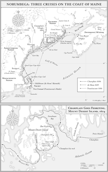
IN THE SUMMER OF 1604, while the settlement was rising on Sainte-Croix Island, Champlain received another assignment. The sieur de Mons asked him “to explore the length of the coast of Norumbega,” which we know as Maine. France and England both claimed that region, as far south as the Delaware Valley. Its destiny would be decided by three French voyages between 1604 and 1606. Champlain sailed on them all, but each had a different commander. He led the first, de Mons the second, and Poutrincourt the last. These leaders worked at the same task, with different results.2
On the first voyage, Champlain’s orders were to find sites for settlement in a warmer climate. He was given a highly specialized vessel called a patache, which a French text defined in 1628 as “a small warship designed for the surveillance of coasts.” Champlain wrote that she was a keel-built ship of “17 or 18 tons,” probably with a length of about forty feet and a draft of five feet. She was fully decked over and designed for voyages in dangerous seas, unlike the smaller open-hulled shallops that he used in more protected waters.3
Champlain’s chart of Sainte-Croix Island has drawings of both these types: a small bluff-bowed shallop above the settlement, and below, a trim little vessel that may have been his patache. She was built man-of-war fashion with a sharp prow, long lines that held the promise of speed, a high forecastle and a raised poop with a battery of small swivel-mounted falconets. Her mastheads were crowned by large crows’ nests. She flew a large French marine ensign, which represented another purpose: to show the flag on a contested coast.4
Champlain’s sketch shows three masts and a very interesting rig. The foremast carried a lugsail that he called a bourcet on a yard that crossed the foremast at an oblique angle. The mainmast was rigged with a large square-rigged sail, and possibly a topsail. A small mizzen added a triangular lateen. These sails could be used in different combinations that were vital to Champlain’s work. The lateen and lugsail could be close-hauled, allowing a vessel to sail very close to the wind. The mainsail and lugsail could be used to run before the wind. In light airs, all sails could be set to capture the slightest whisper of a variable breeze. It was a versatile rig, much favored by explorers.5
A patache was well suited to his method of close-in exploration in a vessel that “furette par tout; ferrets everywhere.” On his coastal voyages, Champlain wasted no time and passed rapidly over stretches of coast that offered nothing of interest. He sought out the promising places, explored them with close attention, and surveyed them in meticulous detail. It was dangerous work on a rockbound coast with strong currents and huge tides, but Champlain found it “very agreeable.”6
Champlain’s patache carried a crew of twelve seamen (matelots). On long exploring voyages he also took several servants, and a gunner, a carpenter, a locksmith, a master-miner for prospecting, and several arquebusiers. Also aboard for this cruise were two Etchemin Indians “as guides on a coast that they knew well.” Altogether, perhaps twenty men crowded aboard the patache. The hold was packed with a month’s supplies—biscuit, peas, flour, salt meat and fish, wine and water, weapons and ammunition, lumber and cordage, sails and spares.7 The Etchemin brought a birchbark canoe, and Champlain added skiffs for surveying.8 On September 2, 1604, Champlain departed from Sainte-Croix Island and dropped down the river. He was happy to be at sea in a good ship, indulging what he called his “passion for discovery.” To read his account is to feel that there was nothing in the world that he would rather be doing—another reason why he was so good at it.9
He quickly discovered that the coast of Maine could be a hard school for a new commander. At the mouth of the Sainte-Croix River, he found Poutrin-court’s vessels lying at anchor and unable to sail for France “on account of bad weather and contrary winds”—probably a nor’easter of the sort that often blows hard on this coast. Champlain anchored and waited for the weather. Three days later he was on his way and enjoyed clear sailing—for all of two or three leagues. Then he ran into a rolling fogbank of a kind that suddenly appears on the coast of Maine. It was so thick that Poutrincourt’s ships vanished from sight.
Champlain pressed on through the fog and stood out into the Gulf of Maine to get clear of the coast. He was a bold explorer, but prudent in the way he managed risk. He made frequent use of the lead line, and discovered “sandbanks, shoals, and rocks in some places projecting more than four leagues out to sea.”10 With more sea room, Champlain steered southwest on the outer side of “a great number of islands.” He gave them names with the help of his Indian guides. A cluster of rocky islets were called the Isles aux Perroquets after a large colony of Atlantic puffins—thousands of wonderful birds with glossy black coats, white pigeon breasts, hooded eyes, and big red and yellow parrot beaks. Today these rocks are called Machias-Seal Island and claimed by two nations. The puffin colony is still there—much reduced, but the only rightful owners.11
Champlain sailed on, past another group of islands with their seaward faces all in a row. He called them the Isles Rangées, the Ordered Islands. Next to them is Roque Island, one of the most beautiful on the Maine coast, with a crescent beach of white sand and blue-green water inside a perfect half-moon cove.12 Further south, he steered closer to the mainland, studied the rocky coast of Schoodic Peninsula and found “many harbors that are beautiful, but not good for settlement.”13 Champlain did not tarry in these places. He rounded Schoodic Point, crossed the handsome sheet of water now called Frenchman Bay, and “on this same day,” September 5, 1604, “passed very near an island which was four or five leagues long.” It was an extraordinary sight: an island twelve miles in diameter with many mountains, “very high and cleft in places,” and peaks as high as 1,500 feet above the water. At first sight Champlain counted “seven or eight mountains, one alongside the other,” and then many more came into view, twenty-seven peaks in all. He noted: “The tops of most of them are bare of trees, because there is nothing but rocks. The woods consist only of pines, firs, and birches.”14
Champlain named this place l’Isle des Monts-Déserts, today’s Mount Desert Island. He often used the adjective désert in his writings to describe an uninhabitable wilderness that he regarded as “terre fort mal plaisante; a very unpleasant place.” Champlain’s idea of natural beauty was a garden rather than a wilderness—an attitude different from our own. But then again his “désert” described the bare mountaintops, and not the island. Champlain was fascinated by this place, as many visitors have been through the centuries.15
On the afternoon of September 5, 1604, he approached from the east and sailed north to the head of Frenchman Bay, far enough to discover that Mount Desert was an island, separated from the mainland by “less than a hundred paces.” All earlier charts had shown it as a peninsula. He was the first to map it for what it was.16
At the head of Frenchman Bay, Champlain came about and sailed down the rocky eastern coast of Mount Desert Island, ferreting in his usual way, very close to the shore. The hour was late and the sun was low in the western sky. The east side of Mount Desert Island lay in the shadow of its mountains. Champlain tells us that since early dawn they had sailed twenty-five leagues.17 It had been a long day, and the lookouts may have been less alert than usual, or more alert to other things. Perhaps they were studying the dramatic scenery of the island as they sailed past a ridge now appropriately named Champlain Mountain. They may have noticed the falcons that breed on its steep seaward cliffs and are sometimes seen swooping overhead at incredible speed, so nimble in the air that they pass food in mid-flight. Just to the south, these Frenchmen might have seen families of sleek otters playing in the sea near what is now called Otter Point.18
As Champlain ferreted along that spectacular coast, he felt a sudden jolt and heard the painful grinding sound that sailors dread. His patache had run on a granite ledge and slipped off again with a hole in her wooden bottom. Champlain wrote, “We were almost lost on a little rock, level with the surface of the water.” Islanders have long surmised that he hit an infamous ledge off Otter Point that has long taken a toll of local traffic. At low water, it is visible with the sea breaking over it; at high tide it lurks below the surface for unwary mariners.19 The blow was a heavy one, and the patache began to sink. The crew must have pumped and bailed while Champlain looked for a place of refuge. Just beyond Otter Point he came to an inlet called Otter Cove, with a broad tidal flat of rounded pebbles that the English call a shingle beach. As the tide flowed out, Otter Cove was a perfect place to careen his vessel. They brought her in with the high tide, and eased her gently on her side as the water ebbed. Champlain and his carpenter splashed through pools of water, studied the ship’s bottom, and found a hole near her keel. Luckily the keel itself and the rudder were undamaged.20
While some of the crew made repairs, others probably foraged on the shore for something to eat. There were birds to shoot, shellfish to gather from tidal pools, and berries in profusion. Today a small stand of wild chokecherry trees stands near the tide line on Otter Cove. In late August and early September they bear abundant fruit, which several generations of this historian’s family have happily harvested. Champlain made a point of supplementing his crew’s rations with fresh food wherever he could find it.
The next day, September 6, 1604, the patache floated on the rising tide, and Champlain resumed his voyage. He sailed southwest, around the bottom of Mount Desert Island, past the present site of Seal Harbor, where summer cottagers in 1904 erected a small monument of granite and bronze in his honor. Champlain continued about two leagues and “caught sight of smoke in a cove which was at the foot of the mountains above mentioned.” This would have been Somes Sound with mountains on both sides, and the safe havens of today’s Northeast Harbor and Southwest Harbor on either side of its entrance.
Several Indians came out in their canoes and studied Champlain’s patache, but were careful to keep a musket shot away. Champlain sent his Indian companions to “assure them of our friendship,” but “the fear they had of us made them turn back.”21 Champlain implies that he spent that day and another night near the island. Probably he explored Somes Sound, which some describe as one of the few fjords on the western side of the Atlantic Ocean. Had he done so, he would have seen crystal-clear mountain streams tumbling from steep mountainsides into the deep water. One of them, now called Man O’War Brook, was a perfect place for a ship to come alongside and fill her water-casks.22
The following morning, September 7, Champlain was still at Mount Desert Island when the Indians returned in their canoes. They came alongside his patache, talked with Champlain’s Indian companions, and exchanged presents: Indian fish and beaver for French biscuit and “sundry other trifles.” The Indians offered to take Champlain to their chief, named Bessabez, on a river they called Pentegouet, now the Penobscot. Off they went through the Western Way, into Penobscot Bay. Champlain wrote, “Almost midway between them, out to sea lies another high and striking island.” He called it Isle au Haut, which it remains today.23
The scenery was spectacular as he sailed into Penobscot Bay, with Deer Island and Castine to his east, Islesboro to the west, North Haven and Vinal-haven dead ahead. Champlain was working without a chart, and he tells us that he threaded his way through many rocks and shoals, “lead line in hand.” He delighted in the beauty of the place. “Entering the river,” he wrote, “one sees fine islands, which are very pleasant on account of their beautiful meadows, belles prairies.” Here again he was more apt to comment on the beauty of open land than dense forest.24
Champlain called it the Norumbega River. He sailed north through its magnificent narrows, with high wooded headlands on both banks towering above his patache. He admired the present site of Bucksport, sailed on as far as the water could float his patache, and came to a big waterfall, two hundred paces wide and seven to eight feet high. He had reached the head of navigation on the Penobscot River in what is now the center of Bangor, Maine.25 “Below the fall,” he wrote, “the river is beautiful, and unobstructed as far as the place where we anchored. I landed to see the country.” He went hunting, probably with his Indian guides, and “found the part I visited most pleasant and agreeable.” Near the river, he found a fine grove of old oaks where “one would think the oaks had been planted there for pleasure.” It is now Bangor’s Oak Street, a neighborhood severely blighted by urban renewal, and a sad commentary on our stewardship of this very beautiful place.26
Indians began to gather, and Champlain’s guides told them that the French came in peace. More Indians arrived, a band of thirty and then the sagamore Bessabez, a leading presence in the region. He would later become well known to other Europeans, who variously called him Betsabes or Bashaba, and they were very much impressed. A Jesuit missionary met him in 1611 and described him as a “man of great discretion and prudence.” He added, “I must confess we often see in these ‘sauvages’ natural and graceful qualities, which will make anyone but a shameless person blush, when they compare them to the greater part of the French who come over here.”27
The Indians also held Bessabez in high esteem. Champlain observed that when he arrived “they all began to sing, dance and leap, until he had landed.” Then they sat in a circle “according to their custom, when they wished to make a speech or hold a festival.”28Another group arrived with a chief named Caba-his and “twenty or thirty of his companions.” They “kept by themselves” and sat apart from the Indians who followed Bessabez. Clearly there had been trouble between them, but they joined in welcoming Champlain. “All were much pleased to see us,” he wrote, “inasmuch as it was the first time they had ever beheld Christians.”29
The meeting place was a stretch of level ground where the Kenduskeag River joins the Penobscot. Champlain came forward with two Frenchmen and two Indian interpreters. Unlike other French explorers, he made a point of approaching the Indians with only a small party, so as not to seem threatening. Champlain acted with extraordinary boldness, but made clear that he came in peace. In his usual way, he quietly prepared for the possibility of trouble. “I ordered the crew of our patache to draw near the Indians,” he wrote, “and to hold their weapons in readiness to do their duty in case they perceived any movement of these people against us.” But the weapons were kept out of sight, and there was no sign of hostility on either side.30
His approach won respect and trust. Bessabez beckoned to Champlain and his companions, and “bade us sit down.” They began the long ritual of a tabagie, and started to smoke together, “as they usually do before beginning their speeches.” Gifts of American venison and waterfowl were exchanged for French biscuits and peas. Then they began to talk. Champlain spoke through an interpreter. He said that he wished to visit the people of this beautiful country, and to be in amity with them, and to promote peace between them and their enemies the Souriquois and Canadiens. He also hoped “to settle in their country and show them how to cultivate it, so that they might not lead a life as miserable as theirs.”31
Bessabez made a graceful reply. He said they were “well content” with what Champlain had said and that “no greater benefit could come to them than to have our friendship.” The Indian leader added that he wanted the French to live in his country, and his people wished to live in peace with their Indian enemies, so that they could hunt the beaver more than they had done before and exchange pelts for useful things. After the speeches, Champlain made presents of “hatchets, rosaries, caps, knives, and other little things.” The remainder of the day was given to song and dance and good food (bonne chère).
The celebration continued through the night. Champlain appears to have had an important asset in these meetings—a remarkable gift of social stamina. When dawn came, the Indians and French bartered beaver skins and trade goods in a spirit of amity and peace, with the promise of serious commerce to follow. Then they parted. Champlain wrote that Bessabez and his companions went in their direction, and “we in ours, well pleased to have made the acquaintance of these people.”32
The next day, Champlain took out his instruments and reckoned the latitude at 45 degrees, 25 minutes north. He was about thirty-seven miles off the mark, not bad for a hard-partying navigator with a traveling astrolabe.33 Then he was off again in his patache, sailing down the Penobscot River with the sagamore Cabahis aboard as his guest. They went twelve leagues to a “little river,” probably the Passagassawakeag River near today’s town of Belfast, with a handsome shoreline and long views across a broad bay.34
Champlain quizzed Cabahis about a mythical place in the interior called Norumbega, which a European traveler had reported to be a city of gold. Probably the word came from the Wabenaki nolumbeka for a mix of rapids and quiet water, of which there are plenty on the upper Penobscot, but no city and no gold. Champlain was quick to dismiss that report as a fable. Gold was not his object in North America.35 He was more interested in the rivers themselves. The Indians told him of portages from the head of the Penobscot to a tributary of the St. Lawrence River. Champlain also asked about the next big river to the south, which the Indians called Qui-ni-be-quy, today’s majestic Kennebec, which also had a short portage to the St. Lawrence. These conversations gave him a clear idea of the region.36
At the present site of Belfast, Champlain parted company with Cabahis and continued down the Penobscot River, which broadened into a great bay. He passed the high ground called the mountains of Bedabedec, today’s Camden Hills, anchored perhaps in Camden Harbor, and sailed on to what is now the town of Rockland.37 Then he turned south along the coast, heading for the Kennebec River. He went about ten leagues, but the wind was against him, the weather turned foul, and his supplies were running low. It was time to turn around. Champlain wrote, “In consideration of the scantiness of our provisions, we decided to return to our settlement [at Sainte-Croix] and to wait until the following year, when we hoped to come back and explore more fully.” On September 23, he ordered the helmsman to come about and head for home. They made good time, running downwind along the coast with the prevailing westerlies behind them—the origin of the expression “down east” in Maine. On October 2, 1604, one month to the day after his departure, Champlain was back at Sainte-Croix Island.38
Champlain had failed to find a site for settlement, but in other ways his cruise was a great success. His meeting with the Indians at Kenduskeag was an important event in the history of this region. Once again, Champlain and other groups of Indians led by Bessabez and Cabahis built a firm foundation for friendship on a basis of mutual interest and reciprocal trust. The result, as at Tadoussac, was another enduring Franco-Indian alliance. It began on the banks of the Penobscot River in 1604 and continued for the better part of two centuries. Champlain had a genius for this work and a rare gift for getting on with others. He had a straight-up soldier’s manner, and Indian warriors genuinely liked and respected him. He did not approve of their religion or their law, and probably he let them know that. But always he treated them with respect and they worked together to reconcile vital interests.39
Unhappily, others did not do it that way. Eight months later, after the hard winter at Sainte-Croix Island, another coastal voyage followed in the spring of 1605. This time the sieur de Mons went along “in search of a more suitable site for settlement, and one where the climate was milder.” De Mons decided to command the mission himself, with Champlain at his side. He brought “several gentleman-adventurers” of “high rank,” and others to a total of about thirty souls. All squeezed into a vessel similar to Champlain’s patache, with provisions for six weeks.
With them were two Indian translators. One was an Etchemin trader named Panounias, who could speak with the northern Indians. The other was his Almouchiquois wife, who could talk with nations to the south. We do not know her name, but this woman of Panounias must have been an extraordinary person. She was the only female whom Champlain mentioned as going with him on an exploring voyage, and he wrote of her with respect. Later, he embellished one of his maps with an Almouchiquois woman of striking grace and beauty. One wonders if she might have been the woman of Panounias.40
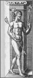
An Etchemin warrior appeared on the title page of Champlain’s Voyages in 1619. It might have been the warrior Panounias, who sailed with Champlain as an interpreter.
From the start, Champlain and the sieur de Mons differed on the plan for this cruise. Champlain proposed to sail directly to the Kennebec and start ferreting where the last voyage had stopped. But the sieur de Mons wished to see the northern coast, and his will was done. Champlain was a loyal subordinate to his commander, but an undercurrent of frustration flows through his written account.
These two good friends had different styles of leadership. Champlain ran a taut ship, centered his missions rigorously on the task at hand, and pushed hard to his objective. The sieur de Mons was an excellent leader in other ways, much liked by those who served with him. He appears to have been more relaxed and easygoing. Under his command, they sailed slowly down the coast, lingering at attractive islands that could serve no serious purpose. They visited an island called Head Harbor, a curious place with an inner basin so tight that down-east sailors still call it the Cow’s Yard.41 Champlain noted that the island was inhabited only by “a great multitude of crows.” The gentleman-adventurers amused themselves by slaughtering large numbers of them, and de Mons allowed them to remain several days for the sport. Champlain named it He aux Corneilles, or Crow Island.42
From there they sailed to Mount Desert Island. Champlain, on his last visit, had found its terrain and soil to be unpromising, and its location offered no access to the interior. But the sieur de Mons wanted to study it, and perhaps the restless gentleman-adventurers wished to see the sights.43 They stayed several days at Mount Desert, then sailed to Penobscot Bay and crossed its broad mouth. Three Indians came out in a canoe from the cape now called Owl’s Head, and said that their chief would like to meet the French. Some “conversation” ensued, but no meeting and no tabagie—a common pattern on voyages commanded by the sieur de Mons.
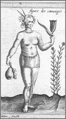
Champlain’s image of this handsome Almouchiquois woman might have been the woman of Panounias, who sailed with him on the coast of Maine, the only female he mentioned as coming on his exploring voyages. She appears on his Carte Géographique, 1612. Her image is also on the title page of the Voyages in 1619.
Suddenly de Mons noticed the time. He had taken two weeks to reach the Penobscot River, which was only two days’ sail from Sainte-Croix. A third of his provisions were gone, and he had not covered the ground of the last cruise. Abruptly he picked up the pace. They left Owl’s Head on July 1, 1605, and made twenty-five leagues in one day to the Kennebec River.44 Here at last they reached the place where the last voyage had ended, and Champlain’s narrative became more detailed. He explored the mouth of the Kennebec, and charted its islands and channels. They met two canoes of Indians who were hunting swans and geese. The French asked the woman of Panounias to “explain the reason of our coming.”45
The Indians offered to take them upstream to meet their chief and led them through an astonishing maze of meandering channels that connect three major rivers in mid-coast Maine: the Kennebec (by the modern city of Bath), the Sheepscot to the east (Wiscasset), and the Androscoggin River to the west (Brunswick). The Indians led the French eastward from the Kennebec through a passage called the Back River, which was easy for a canoe but difficult for a patache.46 They emerged on the Sheepscot River near Wiscasset, and a sagamore they called Manthoumermer came to greet them in a canoe. The woman of Panounias talked with him, and the sagamore “made a speech, in which he expressed pleasure at seeing us, desired to have an alliance with us,” and promised to send word to Indian leaders named Marchin and Sasinou, whom he called “chief of the Kennebec.”
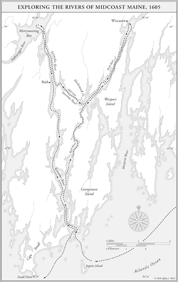
The track of Champlain and the sieur de Mons, July 1–8, 1605.
The sieur de Mons responded with small gifts of hardtack and dried peas, but again there was no tabagie or extended discussion. De Mons did not go ashore as Champlain liked to do. He remained aboard his ship while the Indians came alongside. He seemed uncomfortable in their presence and remained at a distance, unlike Champlain who moved easily among them.47
The Indian guides led the French back through an even more difficult passage to the Kennebec River and what is now Merrymeeting Bay. They were to meet the river chiefs Marchin and Sasinou, but Indian leaders did not show up. Things were not going well with the Indians, and the guides gave them no explanation. De Mons was unable to establish a rapport with them or build a basis for friendship.48
He turned away, sailed down the Kennebec to its mouth, and turned southeast along the coast to “a broad bay in which lie a great many islands,” today’s Casco Bay. Champlain wrote that from a vantage point off the coast, “one sees high mountains to the west,” the White Mountains in New Hampshire. They put in for the night near the present site of Portland. In the morning they continued south, exploring the coast.
On September 10, they came to a bay and small river that Champlain called Choüacoet, today’s Saco. The French crossed the river bar, anchored in a deep pool, and Champlain watched with interest as “many Indians came toward us on the bank of the river and began to dance.” A few hours later their chief Honemechin, arrived with two canoes “and went circling round and round our vessel.” Champlain wrote that he was “good-looking, young and active,” but the French were not able to communicate with him. He was of the Almouchiquois nation, and Champlain observed that their language “differs entirely from that of the Souriquois and Etchemins.” Their Etchemin guide Panounias “could understand only certain words,” and the Almouchiquois woman of Panounias had suddenly disappeared. Champlain does not explain why. Perhaps some misfortune befell this woman, sailing as she was in a small vessel with thirty Frenchmen who were many months from home. Possibly she was weary of the voyage, or wished to visit with her own people. Whatever the reason, she was gone—and just when a translation was most needed.49
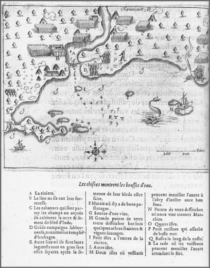
Champlain’s map of the Chouacoit (Saco) River. Here the French met the Almouchiquois, a densely settled farming people. The French were unable to talk with them. De Mons was not comfortable with the Indians and moved on. There was no tabagie on the Saco River, as on the Saguenay, St. Lawrence, and Penobscot.
The Saco Indians were different from the nations to the north and east. The name Almouchiquois was not their own. It came from hunting and gathering neighbors to the north, and appears to have meant something like “dogs who raise corn.” Champlain wrote, “they till and cultivate the land, a practice we had not seen previously.” He went ashore and admired fields clean of weeds, with corn planted in small hills three feet apart, and bush beans that twined around the corn, with squash, pumpkins and tobacco. For tools they used “an instrument of a very hard wood in the shape of a spade,” and the shells of horseshoe crabs.50
Champlain also described their “fixed abodes” and stocks of surplus food. He found large stores of nuts that had been harvested the previous year, and vines with “very fine berries.” He observed: “The Indians remain permanently in this place, and have a large wigwam surrounded by palisades on a high bluff. This place is very pleasant and as attractive a spot as one can see everywhere.” But the French could not communicate with them. They were unable to make any alliance with the Saco Indians.51
The French continued south to a “baye longue” between two capes and a long stretch of sand beaches on the present coast of New Hampshire.52 At the end of the day they rounded the southern “Island Cape,” which is today’s Cape Ann. In the gathering darkness they found no anchorage, and kept on through the night under short sail. The next morning they found themselves in Massachusetts Bay, near the present site of Boston. The Indians were welcoming and wanted to trade. The sieur de Mons remained aboard ship and sent Champlain ashore to talk with the Indians. Champlain gave “each a knife,” which “caused them to dance better than ever.”53
Champlain tried to communicate with them, and with signs and sketches he began to have success. He took a piece of charcoal and drew a sketch of the Long Bay and Cape Ann. With gestures he asked the Indians “to show me how the coast trended.” They took the same piece of charcoal and sketched “another bay which they represented as very large. Here they placed six pebbles at equal intervals giving me to understand each marked a chief and a people,” all of the Massachusetts nation. The Indians drew a large stream and small inlet, which are today’s Charles River and Boston’s Back Bay.54
Champlain continued to communicate with the Indians by sign language for several hours. He took a professional interest in their boats, observing that Indians south of Cape Ann used pirogues, or dugouts, made from solid tree trunks by “burning and scraping with stones, which they use in place of knives.” Champlain appears to have tried his hand at steering a dugout, and found it “very liable to upset unless one is very skilled.” One imagines him struggling to stay upright as the Indians looked on with amusement.55
A good feeling was beginning to grow, but de Mons decided to move on. They sailed seven or eight leagues, anchored near an island in Massachusetts Bay, and saw “many columns of smoke along the coast and many Indians who came running to see us.” Champlain was surprised by their numbers and observed, “These places are more populous than the others we have seen.” The French sent a canoe with small gifts of knives and biscuits, but Champlain wrote sadly, “We could not learn the name of their chief because we did not understand their language.”56
The following day, July 17, they left Massachusetts Bay without making effective contact. Champlain’s account betrayed an air of growing frustration. They sailed south to Scituate, and on to Brant Point, where more Indians in dugout canoes came to greet them. Champlain wrote that they showed “great signs of joy.” A chief appeared and Champlain understood his name as Honabetha: “We received the chief very kindly and gave him good food.” He reciprocated with “little squashes as big as your fist, which we ate as a salad like cucumbers and they were very good.” After that exchange, communications failed yet again.57 The next day they sailed around a “long cape” now called the Gurnet and entered Plymouth Bay. Once again Champlain remarked on the large number of wigwams and gardens. They passed big Indian dugouts that were returning from cod fishing off the coast. The Indians caught them easily on bone hooks tied with hemp. Here again Champlain wrote that many Indians “treated us kindly,” but they did not meet at length and could not talk together.58
The French headed south toward the great sandy peninsula that they named White Cape; we call it Cape Cod. Champlain described the waters of its bay as very clear, and the cape itself as covered with beautiful woods, “very delightful and pleasant to the eye.”59The next day, July 20, they sailed around the outer banks of the cape, facing the Atlantic Ocean. Near its elbow, they came to “a bay with wigwams bordering it all around.” They entered a small harbor and found it “a very dangerous port on account of shoals and sandbanks, where we saw breakers on every side,” and a treacherous bar at the harbor’s mouth. Champlain named it Mallebarre, Bad Bar. It is today’s Nauset.
Champlain wrote that Indian “men and women came at us from all sides dancing.” He observed: “All these Indians from the Island Cape (Cape Ann) southward wear no skins or furs except very rarely; their clothes are made from grass and hemp, and barely cover their bodies and come down only to their thighs. The men and women have their privy parts covered by a small skin … the rest of the body is naked.” He thought that they were a beautiful people, and well groomed: “I saw, among other things, a girl with her hair quite neatly done up by means of a skin dyed red and trimmed on the upper part with little shell beads.”60
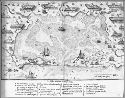
Mallebarre, now Nauset harbor on Cape Cod. Here again, de Mons was unable to establish a rapport with the Indians. Discomfort gave rise to suspicion, which grew into hostility. Fighting broke out between the French and Indians, and appears on this chart.
The next day, the sieur de Mons “resolved to go and inspect their settlement, and nine or ten of us accompanied him with our arms,” in a manner very different from Champlain’s way. De Mons and his men-at-arms marched about a league along the coast through fields planted in corn which was in flower, about five and a half feet high. The fields were very fertile, and full of tobacco, beans, and squash in great variety. The French helped themselves to the crops without asking permission.61 Perhaps at the urging of de Mons, Champlain asked the Indians by sign language if they had much snow in the winter. The Indians explained by gestures that “the harbor never froze over” and “snow fell to a depth of about a foot.” Champlain noted: “We were unable to ascertain whether the snow lasted a long time. I consider however that the country is temperate and the winter not severe.” The sieur de Mons and his men began to talk among themselves, and “the question was opened whether settlement of Acadia should not begin somewhere to the South.”62
At first the Indians had been friendly, but now the tone began to change. The French had come armed as if for war. They took the Indians’ crops without asking and behaved as if they owned the country. Distrust began to grow. On July 23, 1605, a watering party of French sailors went ashore with large metal pots that were very attractive to the Indians. As the French began to fill them, an Indian ran forward and “snatched one by force.” A sailor gave chase but could not catch him. Other Indians came forward in what the French thought a menacing way. The sailors turned and sprinted toward their ship, “shouting to fire our muskets at the Indians who gathered in large numbers.” Several Indians were visiting aboard the French ship. They “hurled themselves into the sea,” and swam for their lives. The French seized one of them and made him a captive. On the beach, the Indians turned against the sailor whose kettle they had taken, shot a volley of arrows, brought him down, and “finished him with their knives.”63
Champlain was aboard the ship. He rallied the crew and “made haste to go ashore,” weapons in hand. To save the watering party, they laid down covering fire at the Indians. Champlain aimed his weapon and fired. It exploded in his hands and he wrote that it “nearly killed me.” The Indians, “hearing this fusillade, again took to flight.” The French ran in pursuit but found “no likelihood of catching them, for they are as swift afoot as horses.” The watering party was rescued and the dead sailor was buried. He had been a carpenter from Saint-Malo.64

Detail of the fight between de Mons’ men and the Nauset Indians on Cape Cod. Here Indian warriors killed a French carpenter. Champlain led an armed party in a vain attempt to rescue him, as other Indians arrived in strength. The Fench vessel is a two-masted barque.
The Indians gathered in the distance, and the French raised their weapons, but the sieur de Mons “ordered them not to fire, as the murderers had fled.” He also ordered the release of their Indian captive as “he was not to blame.”65 With difficulty de Mons was able to control his men, but here again he could not communicate with the Indians. Anger and distrust continued to grow on both sides. Even Champlain was caught up in it. He wrote, “One must be on one’s guard against these people and mistrust them.” It was a sad day for the French leaders. They mourned the loss of their comrade. Another casualty was Champlain’s dream of harmony with the Indians, which failed totally at Mallebarre.66
The Indians were now openly hostile, and made clear that the French should go. On July 25, 1605, de Mons ordered his men to get underway. They sailed out to sea, keeping well clear of Massachusetts, as signal fires behind them began to send columns of smoke along the coast. They stopped at Saco and again at Kennebec, hoping to find Chief Sassinou, but again he did not appear. They met another Indian named Anassou, bartered furs with him, and they were able to communicate. He brought more bad tidings. Champlain wrote: “He told us that ten leagues from [the Kennebec] there was a ship engaged in the fishery, and that those on board under cover of friendship had killed five Indians from this river. From his description we judged that they were English.” This was George Weymouth’s English ship Archangel. The five Indians had not been killed, but kidnapped with their weapons and canoes.67
The Indians of New England were now on their guard, and with reason. On another voyage to Maine by Martin Pring in 1603, the English brought “two excellent mastiffs.” An English explorer wrote, “When we would be rid of the savages’ company, we would let loose the mastiffs and suddenly with outcries they would flee away.” All this opened an opportunity for the French if they could distinguish themselves from the English, but the misadventure at Mallebarre had blurred that difference.68
De Mons and his weary men made their way back to Sainte-Croix Island. They had achieved none of their goals. The sieur de Mons, for all his spirit of humanity, had not been able to work well with the Indians. He had found several sites for settlement, but the Indians turned against him. Many factors were involved: the language barrier and English predators, to name but two. Another major problem was de Mons’ approach to the Indians. He was insecure among them. To the natives, his distance and discomfort appeared hostile and threatening—more so than he intended. An attitude of humanity alone was not enough.
* * *
A third French voyage to Norumbega followed in 1606, with the sieur de Poutrincourt in command. He was a nobleman of high rank, a soldier of proven courage, a Catholic of deep piety, and a gentleman who treated others with kindness. But he had a weakness as a leader. At critical moments his men did not follow him and refused to obey his orders. It had happened in the fall of 1604 when he commanded the company’s ships on a voyage home to France. They had a rough passage, and in the English Channel were almost wrecked on the Casquets. Poutrincourt ordered the crew to help him “shift the sails.” They refused. A friend of Poutrincourt wrote that “only two or three of them did so.”69
It happened again in September 1606, when Poutrincourt led the third voyage along the coast of New England, once again in search of sites for settlement. He proposed to use a barque of the same size as before, but she was not in good repair. Others warned that the barque was unseaworthy, but Poutrin-court was not one for waiting. He decided to make repairs underway and took along the shipwright Champdoré, several artisans, a “store of planks,” and a shallop.70
Without listening to advice, Poutrincourt decided he would sail west-northwest from Port-Royal to Sainte-Croix Island, and then work his way south. Champlain thought it was “not a wise decision.” He suggested, “It would have been more to the purpose, in my opinion, to cross from where we were to Mallebarre, by the route which we knew, and then to employ the time in exploring to the 40th degree or farther south, revisiting on our return the entire coast at our leisure.” But Poutrincourt’s plan prevailed.71 They sailed on September 5, 1606, and got off to a very slow start. Several stops were needed to repair the leaking barque, and Poutrincourt made a long diversion to Sainte-Croix. They were sixteen days getting to Saco. Champlain wrote, “We lost much time in going over again the discoveries that the sieur de Mons had made.”72
At Saco, Poutrincourt brought together three powerful Indian leaders: the Souriquois chief Messamouet, and the Almouchiquois chiefs Onemechin and Marchin. They had long been blood enemies, and Champlain thought it was not a good idea. When these wily old foes met, the French lost control of events. Messamouet made a speech appealing for peace, and then continued the hostilities in a war of gifts.73 With a dramatic flourish he threw trade goods worth more than 300 crowns into Onemechin’s canoe. Onemechin gave in return gifts of corn, squash, and beans, which Messamouet openly despised as not of equal value. Onemechin released a Souriquois prisoner, but gave the captive to Poutrincourt and not to Messamouet. That gift was taken as an insult, in the way it was given. Tone and gesture were of high importance in that world. The chiefs were now angrier than ever, and they parted with a determination to make war. Champlain watched it go wrong, but Poutrincourt insisted that he alone could speak for the French. Perhaps Champlain could have done no better, but an opportunity was lost.74
After that meeting the French departed, sailing southwest to the Island Cape (Cape Ann), and entered an excellent harbor that they called Beauport. It is the site of Gloucester, Massachusetts. Hundreds of Indians gathered and appeared friendly, but things went wrong again. French presents were spurned. An Indian with a wounded foot refused treatment by the French, with expressions of distrust. The French gave a gift of grape juice and the Indians spat it out “thinking … that it was poison.”75
The next day some of the French crew were doing laundry ashore, while others were mending their leaky barque. Poutrincourt caught sight of “a great many Indians” in the woods with weapons in hands. They appeared to be sneaking toward the French who were washing clothes, “with the intention of doing us some injury.” Champlain ran alone to intercept them. They received him well, and began to dance. He asked them to dance some more, which they did, putting their arms inside a circle, and tensions diminished. Suddenly the Indians saw Poutrincourt marching toward them with a file of musketeers, and “withdrew in all directions, being apprehensive lest some bad turn should be done to them.” Here were two French approaches to the Indians. Champlain’s worked; Poutrincourt’s failed. Tensions began to rise again.76 The French learned that a hundred canoes were approaching with six hundred men. Poutrincourt ordered a hasty departure. They put out to sea, and sailed all night. By dawn they were in Cape Cod Bay, where they explored the inner cape, and Champlain admired the cultivated landscape of cornfields, meadows, beautiful beaches, small coves, and fine stands of trees.77 They found “a good safe harbor,” with “plenty of oysters of very good quality,” and named it Port-aux-Huistres. It is today’s Wellfleet, and the oysters are still of “very good quality.”
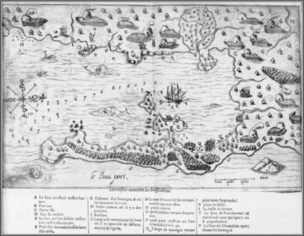
In September 1606, Poutrincourt led a third cruise. They found a handsome harbor and called it Beauport (now Gloucester, Massachusetts). Hundreds of Indians gathered, and Champlain began to make contact, but Poutrincourt approached with arquebusiers, and Indians fled, “fearing some bad turn.” The French departed in haste.
After a brief visit they left the bay, rounded Cape Cod, and sailed south along its Atlantic coast to its outer elbow. There they found a harbor called Port-Fortuné, now Stage Harbor in the town of Chatham. The harbor mouth was barely deep enough to float their ship. They scraped bottom on a shoal and damaged their rudder, but they found their way to an anchorage. Champlain was impressed by the density of Indian settlement and deeply interested in their way of life. “Regarding their polity, government and religious belief,” he wrote, “they have chiefs whom they obey in regard to matters of warfare but not in anything else. The chiefs work, and assume no higher rank than their companions. Each possesses only sufficient land for his own support.”78
Champlain thought that the region was very suitable for a colony, but trouble developed with the Indians. Poutrincourt decided to stay a while. He showed no sign of leaving and appeared to be settling in. The French built an oven on the beach, gathered firewood without permission, and began to bake bread. In the harbor, shipwright Champdoré repaired the damaged rudder while Champlain surveyed the anchorage and made a chart. Each day Poutrincourt went ashore with a heavily armed party of ten or fifteen musketeers and marched through the countryside. He entered Indian villages and “passed among their wigwams, where there were a number of women, and gave them bracelets and rings.”79
The French began to notice columns of white smoke rising on the coast. Champlain wrote: “Some eight or nine days later, on the sieur de Poutrin-court’s going out walking as he had done before, we observed that the Indians were taking down their wigwams and sending their wives and children into the woods, along with provisions and other necessaries of life…. That made us suspect some evil design.”80 Every day Poutrincourt continued to march his musketeers four to five leagues through the Indian settlements. As tensions continued to rise, he sent two men ahead with swords drawn, and instructed them to engage in mock swordplay, a source of puzzlement to the Indians. He also ordered demonstrations of musketry and showed that bullets could penetrate a log. All this was meant to overawe the Indians. It succeeded only in alarming them. Champlain noted that “when passing near us they trembled for fear lest we should harm them.”81
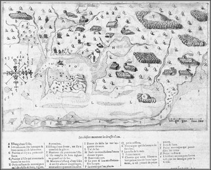
Poutrincourt sailed south to Cape Cod and entered Port Fortune (now Stage Harbor in the town of Chatham). Here Champlain made another chart and mapped the many Indian settlements, but more trouble followed.
On October 14, 1606, Poutrincourt came ashore yet again. This time he erected a cross, which the Indians perceived as a symbol of possession. He put up crosses frequently without asking. Champlain did so less often, usually by permission, and he invited Indians to participate. Tensions were mounting dangerously. Poutrincourt issued standing orders that “all things should be in readiness” to repel an attack, and all the French should come aboard the barque at night. Once again his men refused to obey him. A party of four remained on the beach, tending the oven. Tree defied Poutrincourt’s orders to return aboard. Two others also disobeyed their commander and left the ship to join the beach party. Champlain was shocked by their defiance, “despite remonstrances made to them on the risks they were running and the disobedience they were showing to their chief.”82
Early the next morning, October 15, 1606, a scouting party of Indians crept up to the French on the beach, found most of them asleep and one tending the fire. “Seeing them in this condition,” Champlain wrote, “Indians to the number of 400 came quietly over the little hill” and attacked the Frenchmen. They “shot such a salvo of arrows at them as to give them no chance. All the men were hit by arrows. They struggled to their feet and retreated toward the barque, shouting ‘Help! Help! They are killing us!’”83
Two Frenchmen died on the beach, and a third in the water. A fourth was mortally wounded, and a fifth struggled out to the barque with an arrow in his chest. A sentry on the barque shouted, “To arms! To arms! They are killing our men.” The crew boiled out of the hold, and fifteen or sixteen went ashore in the shallop. Their leaders were Champlain, Robert Gravé, Daniel Hay, the apothecary Hébert, the surgeon, a trumpeter, Poutrincourt himself, and his son Biencourt de Poutrincourt.84
The Indians fled. Champlain wrote, “All we could do was carry off the bodies and bury them near the cross.” One of the dead Frenchmen was found with a small dog on his back, both shot by the same arrow. The dead Frenchmen were laid into the ground with their shirts for winding sheets. During the burial, the Indians “did dance and howl a-far off.”85 The French went back to their vessels, and three hours later the Indians returned. The French fired at them. Champlain wrote: “Whenever they heard the report they threw themselves flat on the ground to avoid the charge. In derision they pulled down the cross, and dug up the bodies, which displeased us greatly and made us go after them a second time.” The bodies were reburied and Indians dug them up again, and “turning their backs toward the ship, they threw sand with their two hands betwixt their buttocks in derision, howling like wolves.” There was desperate talk of seizing captives and binding them with chains of rosary beads! The French baited a trap, but the Indians were old hands at this game. They trapped the French instead, and killed several more of them.
Finally, on October 16, 1606, Poutrincourt ordered his men to weigh anchor and they sailed away, steering south toward Nantucket Sound. Once out of sight from the land, he ordered a change of course and they headed north. Trouble continued to dog them, and they suffered more misadventures at sea. Their shallop bucked and surged at the end of a towline, and smashed the rudder of the barque. Champdoré managed another miraculous repair at sea, and they got back to Port-Royal.
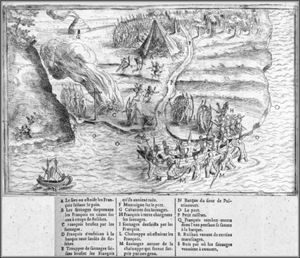
At Port Fortune, Poutrincourt marched soldiers through Indian villages, took crops without permission, and raised a cross without leave, and the Indians were not happy. Poutrincourt responded with a show of force, which provoked an attack on October 15, 1606. The French lost many men—and a region of North America.
Here were three voyages by three French leaders, with three very different results. Champlain, de Mons, and Poutrincourt had many of the same values and purposes. All shared a genuine ideal of humanity, and wanted very much to establish good relations with the natives. But when they actually met the Indians, they conducted themselves in different ways.
Champlain’s first voyage to Norumbega in 1604 repeated the success at Tadoussac in 1603. He approached the Indians with only a few men, and made no display of weapons (though his men were armed and ready on their ship). He sat down with the Indians in another tabagie, took an interest in their ways, honored their customs, and treated them with respect. They responded in the same spirit, with warmth and trust that grew on both sides. Together they formed an alliance that lasted for many years.
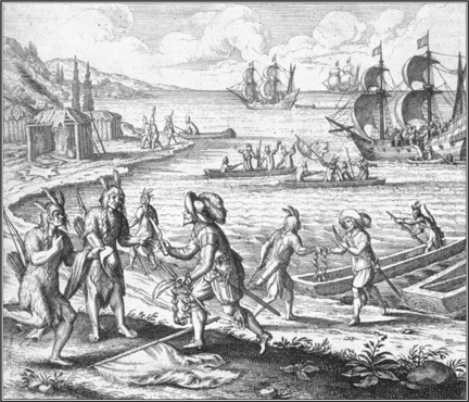
After the voyages of de Mons and Poutrincourt, the French turned north to Acadia and the British became more active to south. Bartholomew Gosnold (in this de Bry engraving) explored the coast and planted a post on Cuttyhunk Island in 1602. Th irty British settlements followed by 1625, and Norumbega became New England.
De Mons’ results in 1605 were mixed at best: a slow beginning, lack of focus, failed communications, and loss of rapport with the Indians. There were no tabagies or other meetings. He kept his distance and seemed unsure of the Indians. They perceived his distance as arrogance and his insecurity as enmity. The result was growing fear and hostility that compounded on itself. It ended in a needless fight.
Poutrincourt’s relations with the Indians were a disaster. He could not control his men and alienated the Indian nations of Norumbega. He was fearful of them and insensitive to their feelings. Poutrincourt went among the Indians heavily armed, marched his men across their lands without warning, took crops from their fields without permission, and erected crosses that were perceived as emblems of possession. The Indians became deeply distrustful of his intentions. As things began to go wrong, Poutrincourt responded with a stronger show of force. He ordered his men to unsheathe their swords and fire their weapons in a demonstration of power. The Indians were terrified of him, literally trembling with fear. They sent away their women and children, and suddenly attacked. The result was a total rupture of relations.
These failures put an end to French colonization south of the Penobscot River and marked the beginning of English hegemony in this region. But with Champlain’s success north of the Penobscot, a new leader emerged in New France. His way of working with the Indians made the difference.