

The Gold Dust Saloon in Gold Point was built in 1908, when the metal of choice in the town’s mines was horn silver, not gold.
WHEN GOLD AND THEN SILVER WERE FOUND in the Utah Territory in the late 1850s, many California argonauts rushed to the area, especially when word of the Comstock lode’s enormous quantities of silver reached their state. The newcomers, however, did not want to be part of a territory that was governed by Mormon leader Brigham Young. (For more, see the introduction to chapter 7, page 227–228.) People in the Carson valley formed their own territorial government, which they had no right to do, because the recognized government resided in Salt Lake City.
Two years later, however, the U.S. Congress effectively legitimized the Carson Valley dissidents, creating the Nevada Territory by essentially cutting the Utah Territory in half. (Nevada, incidentally, means “snow-covered” or “snow-capped,” as in the Sierra Nevada mountain range.) The territory was then rushed into statehood in 1864, just before that year’s national election, because Abraham Lincoln needed more votes for the Thirteenth Amendment (abolishing slavery) and because the Union needed another state to support Lincoln to demonstrate to the Confederacy that the Union was strong. Lincoln signed the statehood proclamation even though Nevada did not have the sixty thousand citizens required for statehood. Patriotism was running high in the new state, and citizens wanted to do what they could to support the united States. Hence their state motto: “All For Our Country.”
The best ghost towns in Nevada demonstrate the wide variety of sites in the Mountain West. Austin is a semighost, with many commercial businesses in disrepair and disuse. Two of its three lovely churches do not hold services. Its old schoolhouse is vacant.
Belmont is more of a true ghost, off the power grid and with no gas station, no restaurants, and only one place for lodging. It also has some of the loveliest and most picturesque remnants in this book.
Goldfield is an excellent example of the boom-and-bust cycle of ghost towns. It features an enormous but vacant hotel, an elaborate but crumbling high school, and an imposing fortresslike courthouse. But Goldfield is barely hanging on, its railroad long gone and its future not promising.
Gold Point is the best surviving mining camp in the West that is not protected as a state park. It has about three dozen wood-frame structures, including false-front commercial buildings and miners’ shacks. Most towns like it have long since disappeared because of neglect, weather, and vandalism. Gold Point is a rare treasure. Rhyolite is a reminder that permanence is relative. Except for its glorious depot and its unusual bottle house, Rhyolite shows only photogenic skeletons of its glory days.
Berlin, like Gold Point, is a wood-frame mining camp, but it is protected as part of a Nevada State Park. Virginia City, the final entry in this book’s six-state canvass of ghost towns, features some of the finest buildings of the frontier West: extravagant mansions, a dramatic church, impressive civic buildings, huge mining structures, and a commercial district of wood-frame and brick edifices unrivaled in this book. Add in a steam train ride, multiple museums, mine and mill tours, gaming-house saloons, restaurants, and busy shops, and Virginia City becomes a vibrant combination of a former mining bonanza and a present-day tourist mecca.

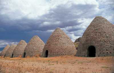
The Ward Charcoal Kilns, southeast of Ely, are some of the finest-made, best-preserved kilns in the American West.
Silver ore was discovered in 1872 in Ward Gulch, and the resulting town of Ward had a population of about fifteen hundred by 1877 and featured two smelters and a twenty-stamp mill. The town was dead by the late 1880s except for sporadic mining attempts in 1906, the late 1930s, and even in the 1960s. Little remains at the site except for foundations and a small cemetery.
You want to visit the Ward area today for the outstanding charcoal kilns, three miles south of the townsite, which were constructed around 1876. The kilns stand thirty feet high, with a diameter of twenty-seven feet. During the operation of these kilns, the vicinity was completely denuded of timber for a radius of about thirty-five miles. (For an explanation of the wood-to-charcoal kiln process, see the Piedmont, Wyoming, entry, page 136–139.)
The kilns provided charcoal for Ward furnaces to smelt the lead ore. When a railroad reached Ward in the early 1880s, it eventually brought in coke, made from coal by a similar process, which put the Ward charcoal kilns out of business.
These kilns are highlighted in this book—even though they are not near a featured ghost town—because of their preservation. They are much more complete than the ones at Piedmont, Wyoming; Nicholia or Bayhorse, Idaho; or Frisco, Utah. They are also more beautiful. The craftsmanship of the Italian makers of these kilns, with their elegant stone entrances, makes them the best charcoal kilns I have ever seen—and I’ve seen hundreds.
WHEN YOU GO
If you are coming from Frisco, Utah, the final entry in chapter 7, drive 80 miles northwest on Utah Highway 21 to a junction with U.S. Highway 50 and U.S. Highway 6 just northwest of Baker, Nevada. From that junction, follow U.S. 50 and U.S. 6 for 45 miles to the marked turnoff for the Ward Charcoal Ovens State Historic Park. (These kilns are called “ovens” in this state park, even though that term is usually used for coal-to-coke structures.)
If you are coming from Ely, the turnoff to the kilns is 12.2 miles southeast of Ely’s junction of U.S. 50, U.S. 6, and U.S. Highway 93. (An earlier turnoff to the site takes you down a long washboard road; I’d advise going beyond that turnoff and taking the much smoother route in.) From that second turnoff, the kilns are 6.4 miles down a very good road, with signs clearly posted.