
· · · MARYLAND, PENNSYLVANIA, DELAWARE · · ·
The white man’s right to freedom’s wide as universal nature;
But beyond the Mason-Dixon line the black’s ain’t worth a ’tater.
In fact I rayther calkilate that this side of it either,
If white man’s justice had its way, ’tain’t worth a ’tater neither.
—ANONYMOUS 1
The Confederate anthem “Dixie” may contain a reference to Jeremiah Dixon, cosurveyor of the Mason-Dixon Line, but Jeremiah Dixon was not a Southerner, and Charles Mason was not a Northerner. They weren’t even Americans; they were British. And the line they surveyed had nothing to do with slavery or the Civil War. In fact, it’s not even a line—it’s three lines.
In 1763 Mason and Dixon were hired to locate the boundary between Maryland, Pennsylvania, and Delaware. Why import two Englishmen when surveyors were falling all over each other in America? Why not hire George Washington or Peter Jefferson or his son, Thomas, all of whom were surveyors? The reason was that this boundary’s stipulations had political and mathematical conflicts. Mitigating those conflicts required surveyors who were not only mathematically brilliant but also politically impartial.
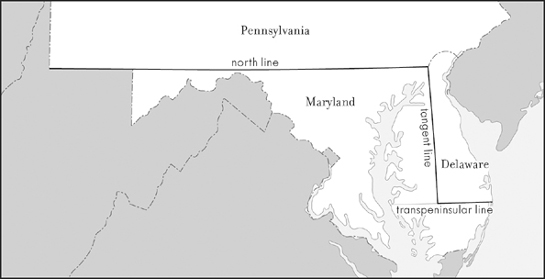
The Mason-Dixon line(s)
These conflicts began when Charles II granted a charter for the creation of Pennsylvania in 1681 that included a semicircle at the colony’s southeast corner to provide a twelve-mile buffer around a preexisting Dutch settlement at New Castle. On the other hand, to protect Pennsylvania’s navigation to the sea, it was given hegemony over Delaware and therefore would negotiate on behalf of Delaware if a boundary dispute should arise. One did, since the region that comprises Delaware had been included fifty years earlier in Maryland’s charter. But Maryland had never governed the region, because Holland had controlled it since 1631. The British had recently ousted the Dutch regime, but Delaware’s Dutch settlers, who were Protestant, opposed control by Catholic Maryland. All these complications, however, eventually became even more complicated.
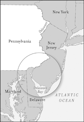
Pennsylvania’s access to the sea
First, England sought to solve the problem by creating Delaware as a separate entity and leasing it to Pennsylvania. Delaware was defined as including all the land below its semicircular northern border extending to the latitude of Cape Henlopen. Then it was discovered that the borders in Pennsylvania’s charter didn’t connect. To make matters worse, Pennsylvania’s southern border at 40° N latitude turned out to be above Philadelphia, whose downtown is 39°57’ N latitude.
Again both sides presented arguments to the Crown. An alternative solution was devised. Another map was then discovered to be wrong. Arguments resumed, and seventy-eight years later an agreement was finally reached. It set the Maryland-Pennsylvania border fifteen miles below the southern boundary of Philadelphia, and the southern border of Delaware at the latitude of Fenwick Island.
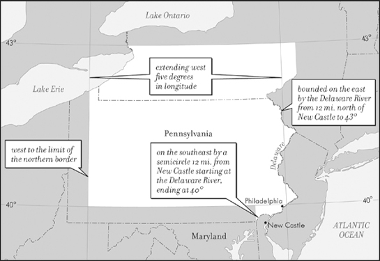
Pennsylvania: 1681 charter borders
Not wanting any further disputes, Maryland and Pennsylvania agreed to seek the finest surveyors available. Pennsylvanian Benjamin Franklin—so revered as a scientist that he’d been inducted into England’s foremost academy, the Royal Society of London for the Improvement of Natural Knowledge—may have recommended Mason and Dixon. Their recent work had been sponsored by the Royal Society, and Franklin certainly knew of it, as would anyone perusing the news in 1762. London Magazine, for example, reported that “Messrs. Mason and Dixon, sent out by the Royal Society to observe the late transit of Venus over the sun, are returned from the Cape of Good Hope and have brought with them a most … excellent and satisfactory observation, for which they have received the thanks of that learned body.” The transit of Venus is a rare event in which the planet passes between the earth and the sun. It can be used to calculate the size of the solar system. How this is done was explained in the Royal Society’s report, published immediately after Mason and Dixon’s return, presenting their data and formulas computing parallaxes of latitude and longitude.
Asking Mason and Dixon to survey a boundary in America was thus akin to asking Mozart to play at a prom. Charles Mason was born in 1728, the son of a miller and baker. He demonstrated such brilliance at a young age that a mathematician in his home town of Gloucestershire helped finance his education. He joined the staff at the Greenwich Observatory, cobbling together an income from his nominal salary, a grant from a cartographic organization, and any fees he could earn for performing scientific tasks. With this he had to support a wife, who died young, and their two sons.
Jeremiah Dixon, five years younger than Mason, never married. The son of a coal mine owner, he was born in Bishop Auckland, County Durham, over 200 miles north of London. His family could well afford his schooling and introduced him to many eminent scientists with whom he established lasting relationships. Dixon was not, however, the stereotypical science nerd. He opted not to pursue an advanced education. He once told a job interviewer that his “seat of learning” for astronomy was “a pit cabin on Cockfield Fell”—the site of his father’s coal mine. Indeed, he may have learned astronomy in order to map mine shafts.2 A brief but revealing entry regarding young Dixon, whose family was Quaker, appears in the records of his local meeting: “Jery Dixon, son of George and Mary Dixon of Cockfield, disowned for drinking to excess.”3 At that time Dixon had already established himself as a surveyor who could, despite any love of liquor, walk off a line (or an arc or squiggle) on the ground exactly where it should be. His surveying skills were so highly regarded that the twenty-seven-year-old was chosen in 1760 to accompany the renowned scientist Charles Mason to the Cape of Good Hope to obtain data on the transit of Venus.
To survey the Pennsylvania-Maryland-Delaware boundary, Mason and Dixon began by establishing that Philadelphia’s southern boundary was the street wall at 30 South Street. From here they went thirty-one miles due west, where arrangements had been made at a farm for an observatory that would be their headquarters for the next four years.
But how did they know they had traveled due west? Apparently, following a compass isn’t sufficiently precise, as Mason and Dixon’s field notes reveal. “Computed the right ascension of the mid-heaven,” they noted, “when the *s [selected stars] passed the azimuth that would intersect the parallel of the post marked West, at 10’ to the westward of the said parallel.”4 Observing stars and crunching numbers, Mason and Dixon proceeded to locate a point fifteen miles due south of the southernmost latitude of Philadelphia—the negotiated latitude of the Maryland-Pennsylvania border.
They next surveyed the Maryland-Pennsylvania border eastward to the Delaware River. But the Maryland-Pennsylvania border doesn’t extend to the Delaware River; it ends at Delaware’s circular border. Why, then, did Mason and Dixon go tromping through Delaware? They did so to locate Pennsylvania’s western border.
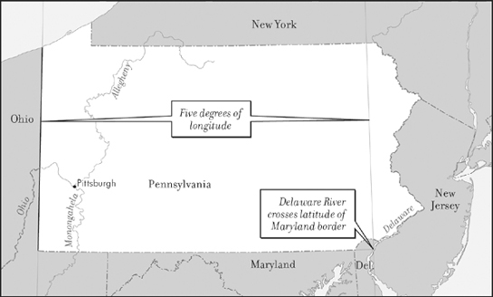
Line to Delaware River: basis for western border
Pennsylvania’s charter had fixed its western border at five degrees from its eastern border. But its eastern border was now entirely composed of the Delaware River, based on an agreement with New York. Since the Delaware River is not a straight line, what point would be used to measure five degrees westward? Based on an agreement with Virginia (whose borders at the time included West Virginia and parts of Ohio), the starting point was where the latitude used for the Pennsylvania-Maryland border met the Delaware River. (Confusing? It gets worse, which is why the states sought out Mason and Dixon.)
It was no picnic for these two eminent surveyors, plodding back and forth over a boundary spanning more than 300 miles, in good weather and bad, often far from shelter—but never far from observing American Indians. Precautions had been arranged, however, as noted in Mason and Dixon’s journal: “July 16, 1767—We were joined by fourteen Indians deputed by the Chiefs of the Six Nations to go with us on the line. With them came Mr. Hugh Crawford, interpreter.”
Coping with Indians was only one of the additional challenges. They also had to cope with boundary stipulations regarding Delaware’s circular northern border, which unavoidably resulted in a wedge of uncertain jurisdiction. (In 1921 the wedge was awarded to Delaware.) To the west, they fretted about colliding with the Potomac River, Maryland’s southern border, since it was not included in the boundary agreement with Pennsylvania regarding Maryland’s northern border. In this instance, they got lucky; their journal noted, “Capt. Shelby again went with us to the summit of the mountain, and showed us the northernmost bend of the river Potomac … from which we judge the line will pass about two miles to the north of the said river.” With the Indians, however, their luck ran out:
Oct. 9, 1767—The Chief of the Indians which joined us the 16th of July informed us that the … war path [east of the Monongahela River] was the extent of his commission from the Chiefs of the Six Nations … and that he would not proceed one step further.
Oct. 26, 1767—Continued the line to the river Monongahela.
Nov. 5, 1767—Mr. Hugh Crawford with the Indians … left us.
Nov. 21, 1767—Seven of our hands left us.
Nov. 29, 1767—Discharged most of our hands.
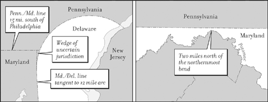
No man’s land (left): the Delaware Wedge; Close call (right): Pennsylvania border and the Potomac
Their work was not quite done, but they had done all they could without risking warfare with hostile tribes across the Monongahela. Mason and Dixon returned to England in 1768. They next became involved in studies of gravity—but not as Mason and Dixon. Mason was hired to perform experiments in Ireland; Dixon’s work took him to Norway.
Dixon returned to his hometown at the conclusion of this research. His family’s wealth enabled him to live comfortably, engaging, when he chose to do so, in local surveying projects. He passed away in 1779 at the age of forty-five.
Mason, on the other hand, remained active in scientific endeavors and in seeking sufficient income. Two years after his return to England, Mason’s financial needs multiplied when he remarried, as he and his second wife produced six children. Following the American Revolution, Mason brought his family to Philadelphia in hopes that he could earn more money, owing to his and Dixon’s boundary line being so widely known among American leaders. Upon arriving in September 1786, he contacted his now eighty-year-old associate from years gone by, Benjamin Franklin. “I have a family of wife, seven sons, and a daughter, all in a very helpless condition, as I have been confined to my bed with sickness ever since I came to town, which is twelve days,” he wrote. “Had I been able I would have laid before you something curious in astronomy. The expense of putting it in execution would be very trifling. I do hereby send you a plan of the design.”5 What that celestial oddity was remains unknown. Mason died shortly after sending Franklin his letter.
His name, however, along with that of his surveying partner, lived on, engraved in the American psyche as the border between North and South. Its earliest recorded use for this purpose may well have been when Virginia Congressman John Randolph ominously declared in 1824 that “we who belong to that unfortunate portion of this confederacy which is south of Mason and Dixon’s line, and east of the Allegheny Mountains, have to make up our mind to perish … or we must resort to the measures which we first opposed to British aggressions and usurpations.”
Why was this said in 1824, as opposed to, say, 1800? Very likely because the 1820 Missouri Compromise established a line above and below which slavery was prohibited or permitted in the Louisiana Purchase. That line was the latitude 36°30’ (with the compromise exception of Missouri). No such boundary existed in the eastern states. Indeed, when Randolph made his reference to the Mason-Dixon Line, slavery was still allowed in Delaware, New Jersey, New York, Connecticut, and New Hampshire. But—and herein the reason for Randolph’s reference—three of those states had already enacted laws for the gradual abolition of slavery. New Hampshire did not enact a law to end slavery until 1857, and Delaware remained a slave state through the Civil War, though of course it was not a Confederate state.
But the Mason-Dixon Line to which Randolph referred didn’t include its transpeninsular and tangent lines defining Delaware. He meant only the line dividing Pennsylvania, the nation’s southernmost free state, from Maryland, the nation’s northernmost slave state. As for the exceptions—Delaware extending slightly north of Maryland, and New Hampshire with (as per the 1800 census) a total of eight slaves—neither was enough to stand in the way of a catchy phrase.