
The United States in 1829 was a little more than seventeen hundred miles long from north to south and about the same distance (counting the Louisiana Purchase) from east to west. Beginning with Cape Cod and widening farther south was the Atlantic Coastal Plain, a low to gently undulating surface that, at the time, offered easy penetration of the interior. From Cape Cod north and immediately to the interior of the coastal plain farther south was the Appalachian System. The line of contact between the coastal plain and the Appalachian System is termed the Fall Line. It is here, at the head of deep water navigation, where many cities developed. On the other hand, New England's rocky coast was very irregular and encouraged the development of many ports. Two general regional terms used from Maryland south were Tidewater, for the easily penetrated coastal plain, and Piedmont, for the gently rolling approach to the mountainous Appalachians west of the Fall Line. West of the easily penetrated Appalachians lay a great Central Lowland, drained by the navigable Mississippi River system.
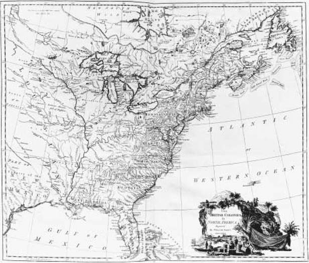
The British Colonies in North America. An engraving, dated 1777, by the English cartographer William Faden.
Western Europeans, in encountering the new environment, found many parallels with what they had known at home. Much of the animal life was similar. For what was not similar they adopted Native American names (raccoon, opossum, for example). The same followed for vegetation. Other than for Native American clearance, forest prevailed, until the grasslands of the Central Lowland were penetrated. In general the climate was more humid than in Europe, with many large rivers providing abundant waterpower sites, especially in New England. Atlantic America had a continental, rather than a maritime, climate, meaning that there were greater temperature differences between winter and summer than in Western Europe. Winters were more severe in New England and the northern interior and summers longer and much hotter in the South than was the case in Western Europe.
Soil fertility varied greatly. Much of the coastal plain and New England had relatively poor soils. There were, of course, exceptions. For example, the Black Belt of Alabama had fertile soils, as did river bottomlands in Mississippi and Louisiana. Large areas of excellent soils could be found in the Piedmont and Central Lowland, notably in Illinois, Ohio, Indiana, and Iowa.
By 1754 people of African and European origin occupied a broad area in eastern North America. In the area controlled by the British in what would later become the United States, continuous coastal settlement could be found from present-day Maine through North Carolina. A short gap intervened between coastal North Carolina and South Carolina and Georgia. Navigable rivers, such as the Hudson in the North and Savannah in the South, had encouraged settlement toward the interior, and movement down the great interior valley of the Shenandoah was just beginning. Outliers of settlement to the interior included, in the North, French settlement at Detroit and, in the Illinois Country, along the upper Mississippi in the vicinity of St. Louis. In the Southeast, Spain had settled Saint Augustine and in the Florida panhandle. Spanish and French settlers also occupied a coastal strip around Mobile Bay in what later became Alabama. French and some Spanish settlement could be found at and near New Orleans on the lower Mississippi. To the interior were located various Native American tribal entities, among the most notable being the League of the Iroquois centered on New York's Mohawk Valley and the Creek Confederacy of the Southeast. There were considerable cultural differences between the European and African settled areas. Many of these continued well beyond 1829. New Englanders came disproportionately from the area of East Anglia in Great Britain, north and east of London. Congregationalism was the major religious following. Few held slaves. In New York and New Jersey people who were either Dutch in ethnicity or who had become Dutch in culture comprised an important segment of the population. Many held slaves, and the Dutch Reformed Church was regionally important. In southeastern Pennsylvania and nearby areas, English Quakers were dominant. Slavery was rare. Germans of various Protestant faiths had also settled in Pennsylvania as well as people from the north of Ireland, who generally arrived as Presbyterians but often, in the move to the frontier, became Baptists or Methodists. African slaves could be found in the Tidewater, in many cases making up more than half the population. Slave owners were from many parts of Great Britain and northern Ireland and often were communicants of the Anglican Church. French and Spanish settlement favored Roman Catholicism and, in the South, slavery.
New England was the most heavily populated region, with about 400,000 people, overwhelmingly white. Virginia and the Tidewater country through North Carolina had almost as many people, but here initially culturally diverse Africans from several areas in West Africa often dominated in numbers. The Hudson Valley and areas adjacent had about 100,000 people, southeastern Pennsylvania had about 230,000, and coastal South Carolina and Georgia had about 90,000, again with Africans in many places often outnumbering the whites. In addition to the contrasts in numbers and religion and ethnicity were differences in age and sex ratios. The frontier tended to have more white males than white females, whereas longer-settled areas tended to have the sexes in equal proportions or be slightly dominated by females because of the outmigration of some males to the frontiers. Where slavery dominated there were often severe differences in sex ratios as the focus of owners early on was for (preferably male) field laborers.
To the interior, the Native American population was also quite varied culturally, in language, subsistence, forms of dwellings, and many other things. Although there is no real agreement on their numbers, there is no question that by 1754 many had died of introduced European and African diseases. In the North, smaller villages prevailed, whereas in the Southeast some settlements reached several thousand inhabitants. In subsistence Native Americans varied from the largely hunting and gathering of northern New England, fishing along the coast of southern New England and Long Island and southern Florida and the Gulf Coast, to farming in much of the interior where a long growing season allowed cultivation of corn, beans, and squash. Dwellings were regionally quite varied, with examples such as the Quonset longhouse of the North, the domal wigwam of the mid-Atlantic and the hipped-roof, rectangular wattle-and-daub house of the Southeast.
Decennial national censuses beginning in 1790 give a much better picture of population trends, at least in numbers. By the census of 1830, for example, the population had grown to almost 13 million. Over 18 percent of this population was African American, over 86 percent of whom were slaves. By 1830 natural increase had evened the ratio between the sexes among African Americans to about 102 males per 100 females. In newly settled slave states, the ratios of African Americans to whites was greatly different. In Mississippi, for example, almost half the population was African American, and of this half over 90 percent were slaves. Using New Jersey as an example, in 1830 only a little more than 6 percent of the population was African American, and of these only a little over 10 percent were slaves.
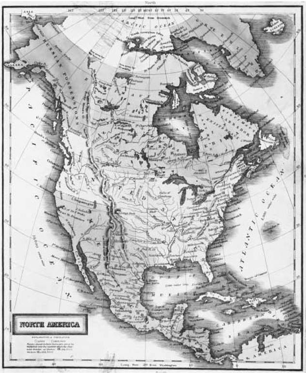
North America. A map of the North American continent, published in 1829 by D. F. Robinson and Company of Connecticut.
Nationally, among whites, the gender ratio was about 104 males to 100 females. These ratios among whites varied greatly with the length of settlement. In New Jersey, for example, an older seaboard state, there were 103 white males to 100 white females. In Michigan Territory, a newly developing area, the ratio was 138 to 100.
The growth in numbers by 1830 had come about largely by natural increase. Exceptions to this included the continuous flow, before the Revolution, of Scots-Irish from northern Ireland, through the port of Philadelphia, westward into Pennsylvania, and then southward to the interior. The other major exception was the displacement of thousands of French settlers after the Seven Years' War from Acadia (present-day Nova Scotia). Many of these people found their way to southwestern Louisiana and became the ancestors of the present Cajun population.
By 1829 Europeans and Africans settled portions of the United States had expanded into what are now the states of Michigan, Wisconsin, Illinois, Indiana, most of Ohio, Missouri, Mississippi, Alabama, and Arkansas. Several events had allowed this to occur. The French threat had been removed by their defeat in the Seven Years' War. Thomas Jefferson's purchase of the Louisiana Territory from Napoleon in 1803 opened the vast interior to American settlement. There had also been several Indian wars. For example, the League of the Iroquois had sided with England during the American Revolution and had been defeated by the Americans. They were no longer a barrier, allowing New Englanders in particular to pour westward through New York's Mohawk Valley. A little later this was the route of the Erie Canal, begun in 1817 and completed in 1825, adding to the flow of settlement west and of produce east.
Possession of Florida began with accessing a portion of the present state of Louisiana (the Florida parishes) in 1819. This was completed in 1822. Further, Native Americans displaced westward, and improvements in transportation (for example, the National Road, the Wilderness Road through Cumberland Gap, and the great expansion of steam navigation in the 1820s) made westward migration much easier.
In an economic sense, whether in 1754 or in 1829, agriculture, with several regional variations, ruled. New Englanders had originally come seeking religious freedom and planned agricultural villages like those in their homeland. Much of New England, however, proved to be hostile to agricultural endeavors, and many people increasingly turned to producing naval stores (turpentine, pitch, and resin) and timber for shipbuilding and to fishing the rich coastal waters for cod, which was salted and sent in large measure to the Caribbean and Mediterranean. The middle colonies of New York, New Jersey, and Pennsylvania were known as the bread colonies, famed for production of wheat, which was milled into flour and exported in barrels to Europe and the Caribbean. Some areas had regional specialties. Southwestern New Jersey, for example, specialized in growing corn to feed hogs, the source of the hams that were exported through Philadelphia. Also in New Jersey were the small farms established by New Englanders that specialized in apples, which were transformed into the area's famed apple brandy.
The Tidewater country of Maryland, Virginia, and North Carolina early turned to cultivating tobacco with the use of slave labor. North Carolina was especially known for producing naval stores. Indigo, which produces a blue dye, was grown on the coastal plain in North Carolina, especially in South Carolina, Georgia, Spanish Florida, and French Louisiana. Long-staple cotton was produced on the Sea Islands off the Georgia coast. Corn was raised everywhere. Cattle and swine were ubiquitous, roaming free.
Sheep characterized New England more than any other area. By the 1820s the agricultural regions had changed greatly. Farms were being abandoned in New England. Many farmers had left for the West (western New York to Michigan) or to sites where waterpower could be harnessed for manufacturing. The midwestern Corn Belt was in formation, with rapidly growing Cincinnati termed "Porkopolis."
In the middle states, farming remained viable, although there was a shift to livestock to provide protein for the growing cities. Indeed many farmers in this region as well left for the West. In the plantation South, with the introduction of Eli Whitney's cotton gin, upland, short-staple cotton became a major crop in the Piedmont. Cotton production had also moved to central Tennessee, the so-called Black Belt of Alabama, and the bottomlands along the Mississippi in Louisiana and Mississippi. Land worn out by tobacco farming had been abandoned, but wide areas in Virginia's Piedmont were still devoted to producing the crop. Tobacco was now also to be found in the Blue-grass region of Kentucky. Rice replaced indigo in coastal South Carolina and Georgia. In southern Louisiana's Red River and Mississippi bottomlands, sugar had become king.
Overall, when compared to agriculture, industry was a very minor activity in 1754. Industry was mainly to be found from Maryland north and consisted of grist and saw milling, ironworks, shipbuilding, and distilling. Ironworks were especially to be found in Pennsylvania and New Jersey and the milling of grain especially in the middle colonies. Even by 1820 the use of waterpower for manufacturing outnumbered the use of steam engines by a factor of at least one hundred to one. Factory jobs were to be found in few locations, mainly southeastern Pennsylvania, coastal Connecticut, and eastern Massachusetts. The first major planned manufacturing center, based on textiles, was Paterson, New Jersey, planned in 1791, utilizing the waterpower of the Great Falls of the Passaic River. But it was places in New England, especially in Massachusetts (Lowell being the most commonly cited example), that were able to capitalize on the combination of humid climate, relatively great fall in water from place to place, people abandoning farms and moving to town, interested investors, ease of transport, and availability of cotton from the expanding plantations of the South.
In 1754 mining was quite limited, with iron ore being the major material sought. By 1829 iron mining and production were quite widespread and especially followed in Pennsylvania and New Jersey. Shaft mining for copper began at North Arlington, New Jersey, in about 1712, interrupted by the Revolution, then continued well into the nineteenth century. The mining of glass sands began in southern New Jersey in 1739, and production there was still under way in 1829. Gold was found as early as 1799 in North Carolina, and mining activity was ongoing there and in Georgia in the 1820s. More important economically was the production of salt in the vicinity of Syracuse, New York. Clay was widely mined for pottery and bricks.
In both 1754 and 1829, the key to settlement and productivity, whether agricultural or industrial, was transportation. The seaboard settlements obviously had an early advantage, with immediate access to marine navigation. In 1754 Philadelphia was the major port, with, from north to south, Boston, Newport, New York, Charleston, Savannah, and New Orleans being of importance. By 1829 New York had eclipsed Philadelphia to become the leading port, partially owing to the opening of the Erie Canal.
New Orleans had become much more important owing to the settlement of the trans-Appalachian West and the development of steam navigation on the Mississippi. In 1754 overland transportation, initially along paths opened by Native Americans, was very poorly developed. Even in 1800, for example, overland travel from New York to Illinois took approximately six weeks. The Capital Turnpike, completed in 1795 between Philadelphia (which was then the capital) and Lancaster, set the stage for private investment in toll roads. Largely because of this, by 1828 the trip from New York to Illinois had shrunk to about three weeks. Where they existed, canals both speeded travel and made the movement of cargoes less expensive. Before the opening of the full length of the Erie Canal, for example, a wagon load took twenty days to reach Buffalo from Albany at a cost of a hundred dollars. After the canal opened, in 1825, the time was reduced to eight days and the cost to twenty dollars. After 1829, of course, the rapid expansion of canals, steam navigation, and the coming of the railroad further revolutionized transportation.