CHAPTER 6
In 1735, Benjamin Franklin, writing as his alter-ego Richard Saunders in Poor Richard’s Almanac, made the observation of human beings that “some are weatherwise, some are otherwise.”1 It is certainly easy for us to be weather-wise in the twenty-first century, with a staggering array of meteorological technology at our fingertips. Paid, professional weather-people spend the entireties of their work weeks monitoring the slightest changes in wind speed and humidity for indications of what atmospheric conditions we’ll enjoy ten days from now. We relax in the comfort of knowing that if something bad is around the corner, we will know about it early enough to prepare. Farmers and florists can cover their delicate crops; homeowners can board up their windows and sandbag their doorways; people who live in flash-flood areas can remove themselves to higher ground.
The ability to foretell our weather future is a fairly recent development; Dr. Cadwallader Colden of Philadelphia bought the first thermometer/ barometer for use in monitoring the weather in 1718. The following decades saw scientifically-minded men try their hand not only at recording the weather, but forecasting it as well. In 1743, Benjamin Franklin made plans to watch a lunar eclipse, but a storm obscured his view. In conversing with contacts in Boston, he discovered that they had been able to view the eclipse, and the storm that had hit Pennsylvania with such unfortunate timing had arrived in Boston many hours later. Intrigued, Franklin began monitoring the movement of storms, and in the course of his studies he theorized about the existence of high- and low-pressure areas. In the years just prior to his death, he used the presence of hail in the summertime to hypothesize that the upper atmosphere must be colder than the air below it.
For Pennsylvanians without the inclination or resources to study the weather on their own, they had to place their trust in God—and an almanac. Almanacs were often a mixture of scientific observation and superstition and provided farmers with at least a thin sense of control over their environment. An almanac could tell farmers what kind of weather was likely to occur and provided them with a blueprint for agricultural success based in the moon and stars: sow grain only when the moon is waxing; plant potatoes only in the “dark of the moon”; slaughter cattle during the full moon; if a rooster crows after 10pm, it will rain the next day.2 The fact that we in Pennsylvania continue to use a groundhog to predict an early spring is an amusing holdover from a time when these were deadly serious considerations. A late frost could destroy an entire year’s worth of food supply.
Meteorology in eighteenth- and nineteenth-century Pennsylvania was especially difficult because the Quaker State is notorious for its reliable climate, which provides the ideal temperatures and rainfall for wheat, but wildly changeable weather, which can wipe out a bumper crop in the course of a 30-minute hailstorm. Writing to Lord North in 1683, the Proprietor himself, William Penn, noted that “The weather often changeth without notice, and is constant almost in inconstancy!”3 A prodigiously snowy winter could be sandwiched between two mild winters; a flood year can follow a drought year and be in turn followed by another flood year.
Summers in Pennsylvania were—and continue to be—hot and humid, with about 30 to 40 thunderstorms per year. Pennsylvania’s abundant rainfall and plentiful waterways created a farmer’s paradise; southeastern Pennsylvania was famous as the breadbasket of the British empire, exporting more wheat and flour than almost anywhere else in the world in the mid- to late eighteenth century. The creeks of Delaware County provided power for 43 textile mills, 32 flour mills, 45 sawmills, eight paper mills, and other mills for processing clover, plaster, and more. More than 45 bridges spanned these creeks, providing reliable transportation routes from the mills to the ports of Philadelphia, Chester, and Wilmington. In short, it was hard to imagine a place where the events of August 5, 1843 could have been more disastrous.
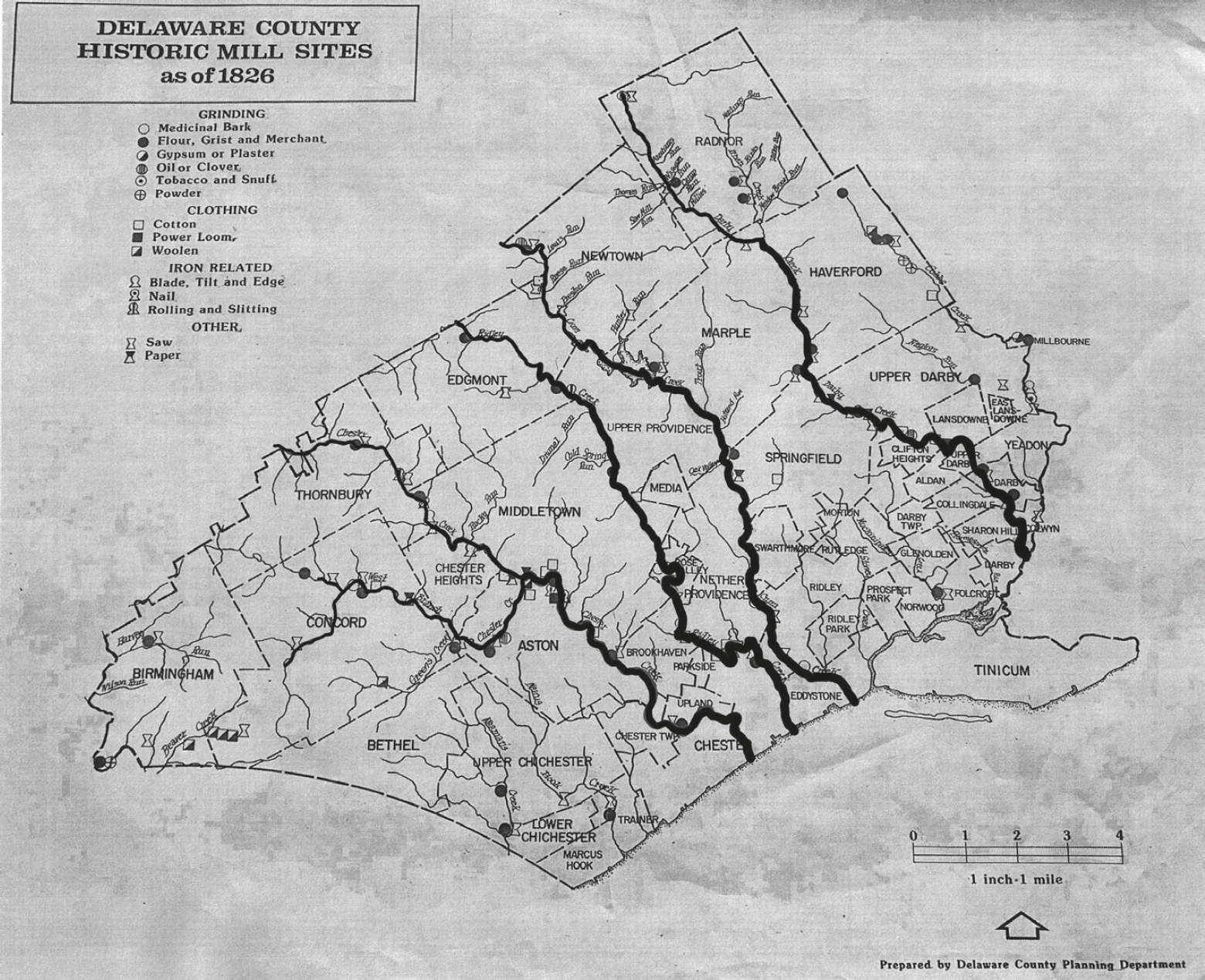
Delaware County Historic Mill Sites map, showing Chester Creek (far left), Ridley Creek (middle left), Crum Creek (middle right) and Darby Creek (far right). (Delaware County Historical Society)
The summer of 1843 was a season of extremes; in July Philadelphia recorded a sweltering 100-degree day. Despite the record-setting temperatures a month before, the morning of August 5, 1843 was cool and dark, with heavy clouds over the sun that promised a wet day ahead. It started raining at around 7am and continued off and on for most of the day, giving the ground a much-needed gentle soaking. From 7am until that afternoon, about three-quarters of an inch of rain fell. It wasn’t even enough precipitation to raise the creeks, which was one reason why no one could have expected what happened next.
Historians looking back at the events of August 5, 1843 often use the modern term “Frankenstorm,” and it’s a bizarrely accurate description. While the storm was confined mostly to Delaware County (with slivers of Chester County and Montgomery County included), conditions differed from township to township so drastically that one cannot help but think of three or four completely different storms stitched together, which all just happened to occur in the same four- or five-hour period. In the aftermath, the Delaware County Institute of Science was forced to publish their report of the incident neighborhood by neighborhood.
After seven hours of gentle rain, thunder started to roll around 2pm. The clouds lowered, casting shadows over the landscape. By 3pm, it was too dark to read a book without lighting a candle. Residents of Delaware County looked into the skies to see two massive stormfronts—one moving in from the southeast, the other approaching from the northwest—and they were moving toward each other. John and George Lewis later reported that they watched the storms collide near Springfield, and they pushed and raged against each other like two boxers in a match, slicing the air with unceasing bolts of lightning and peals of thunder. Eventually the storm from the southeast prevailed, bowling over the northwestern storm and absorbing its power. One witness later described the clouds as being so dense and low that they appeared to “drag upon the treetops.” The combined storms brought constant and frighteningly vivid flashes of lightning, followed by ground-rumbling continuous peals of thunder, surrounding the land between in a horrifying theater of light and crashing noise. The lightning and thunder were terrifying on their own, but the strangest part of the storm was the wind.
In the nineteenth century, the term “boxing the compass” came to be used figuratively, but the phrase refers to repeating the 32 points of the compass. This was an apt description of the wind that day, as it veered wildly from southeast to northwest and everything in between. A few witnesses reported very strong winds, and the way they whipped around the points of the compass leveled orchards and fences, scattering trees perpendicular to each other as the winds changed direction. In Bethel Township, the peach trees in Mr. Clayton’s orchard fell to the northeast, while the apple trees in the neighboring orchard faced southeast. The roof of George Miller’s house was lifted off and carried away; his clothes, bed, and linens were found a mile away. At John Larkin’s farm two miles north of Bethel Township, a straight-line wind obliterated two hundred cords’ worth of timber in a narrow swath no wider than two hundred yards. (For a mental picture, two hundred cords of wood are equivalent to around 400 pickup trucks of firewood.) Worse than the wind, the storms also brought with them tornadoes, twisting trees apart at a height of 20 feet or more from the ground and flinging the debris across fields and into houses. Acres of woodland would later be found with ancient oaks torn off midway up the trunks like they’d been shorn by some enormous scythe.
The roiling mass of storm clouds brought unimaginable amounts of rain; when they collided over Delaware County, they unleashed their combined moisture in a blinding torrent. This, too, varied from town to town. Newtown Square reported just over five inches of rain in two hours, but in Concord township a continuous sheet of rain dropped 16 inches in two hours. In Upper Darby, an inch of rain fell in just 15 minutes.
By 7pm the worst of the storm seemed to have moved on, leaving an eerie quiet in its wake. But that quiet was quickly and violently shattered by what the writers of the report can only, insufficiently, describe as the “phenomenon.” The famous creeks of Delaware County swelled and roiled with rainwater runoff, creating a wall of water that surged down the creeks toward the Delaware River. The Delaware County Institute of Science observed that:
The description given by many persons of its approach in the lower districts of the county, forcibly reminds one of the accounts he has read of the advance of the tides in the bay of Fundy, and other places where they attain a great height. Some speak of the water as coming down in a breast of several feet at a time; others describe it as approaching in waves which followed each other in rapid succession; but all agree that at one period of the flood, there was an almost instantaneous rise in the water of from five to eight or ten feet.4
The word that carries the most weight in this quote is “instantaneous.” In a place like Delaware County, whose creeks are dotted by so many mills, dams, and bridges, the result was catastrophic. At the headwaters of the Chester, Darby, and Ridley Creeks, floodwaters reached depths of ten feet or more, but these areas experienced little damage. An alarming problem was developing further downstream, where the debris from the headwaters began to travel the path of the deluge and pile up against the bridges and mill dams further south and east. The Darby Creek, as it passed through E. Levis’ meadow, reached a depth of 14 feet, but a few hundred yards downstream it ballooned to 17 feet as fallen timber formed a natural dam across the waterway. Lying just below this obstruction was Palmer & Marker’s stone paper mill, of which more than 30 feet of the building was carried away. Stones from the mill were later found strewn over three quarters of an acre. After that was the cotton factory of John and Thomas Kent; the building and all of its equipment were washed downstream.
During the storm, Michael Nolan had a feeling that his house might be in danger, so he and his son had left their home to seek another place where his family could take refuge. They left Mrs. Dolan, a relative named Susan, and four other children at the house. Having found someone who could take them in, they returned five minutes later to find their house surrounded by floodwater. Mr. Dolan and his son watched desperately from higher ground as the walls of their sturdy home were torn from their foundation. Of those still inside the house when it collapsed, only the two adult women survived, with Susan being rescued from a tree four hours later. The children—James, Thomas, Michael, and Ann, ranging in age from three to fifteen—all drowned. They weren’t the only victims of Darby Creek that day. Two men standing on a bridge at Darby were drowned when it collapsed; the body of the first was discovered four days later in a field two miles downstream. The other wasn’t discovered for two weeks, buried in a pile of debris. They were only 19 and 21 years old.
The Crum Creek crested even higher than the Darby Creek, at 20 feet, and while the damage to property was devastating at least no lives were lost. The bridge in West Chester at Strasburg Road, which cost $10,000 when it was built and spanned 32 feet, was destroyed, as were the sawmill and plaster mill of John C. Beatty. Beatty recalled the events leading up to the deluge:
At about five o’clock, P. M., the creek began to rise, when several of the workmen, with myself, went to the shop to secure some timber which was afloat and likely to be washed away; but we had not time to make any thing safe, before we were obliged to make our escape, which, if we had not done at the time we did, we must have been washed with the mills down the creek. The water in the space of ten minutes, rose, I think, seven or eight feet. The bridge was the first that went—it seemed to fall over as if there was no strength in it—then my wood-house, with about ten cords of wood and a lot of chestnut rails. Next the head gates were bursted out, when the edge tool factory went down with a tremendous crash, and in an instant there was nothing to be seen but water in the place where it stood. The sawmill was the next to yield to the violence of the flood, and all the logs, plank, boards, &c., near it were carried away. The walls of the plaster mill and finishing mill were undermined, and those in front fell out, leaving the back and end walls in such a wrecked condition, that they fell in a few days after. About half the race bank, and eight yards of the breast of the dam, were completely swept out. All the hammers, anvils, unfinished tools, coal, &c., were swept away, or covered with stones and dirt below.5
All of this debris careened next through a roofed lattice bridge with a 90-foot span, then filled the tenant houses of the Strathaven and Avendale cotton factories up to the second floor, forcing their inhabitants to take refuge on the roofs. The water rose so rapidly that the Avendale factory workers didn’t have time to rescue the five horses in its stable; all five animals drowned.
On the Ridley Creek, the first property to sustain damage was Amor Bishop’s mills (in Ridley Creek State Park), and two of the tenant houses were carried away entirely. By the time the waters reached the woolen factory of Samuel Bancroft, they were 20 feet deep and at their most destructive. The flood picked apart a 50' × 36' section of the mill and wiped four houses nearly off their foundations. One of those houses belonged to George Hargraves, who lived there with his wife, five children, and George’s brother William in the middle of a series of four rowhomes. In attempting to move their valuables out of the basement to save them from damage, the Hargraves family didn’t see the waters rising around the house. By the time they did, it was too late. They retreated to the second floor, where they hid in a bedroom, with Jane Hargraves clutching her infant in a corner of the room. William, leaning against a wall, suddenly felt the wall flex—then it broke free, and he, George and four of the children were washed into the creek. Jane and the baby survived because the corner where she stood, only a few feet wide, remained attached to the wall. Amazingly, on the other side of the wall in the neighboring rowhouse stood Thomas Wardell Brown, his wife and child, who also survived. William later reported that he was washed half a mile down the creek, repeatedly struck by debris, until he managed to grasp the branches of a tree and drag himself out of the water. He saw his brother George and the four children go by him on a bed, and George cried out “Hold on to it, William!” George had barely gotten these words out of his mouth before the water flipped the bed, scattering him and the children into the debris-choked Ridley Creek. Their bodies were found a mile downstream. George was 38 years old; Sarah was 13; Andrew was 11; George was nine, and little Samuel, found clasped in his father’s arms, was only six. Ridley Creek ultimately crested at 21 feet.6
The worst of the damage, and the highest number of casualties, was to come in the most westerly of the affected creeks, Chester Creek. Chester Creek has two branches, the east and west. On the east branch, which rose more rapidly than the west, the waters carried off the entire tilt mill of Thomas Thatcher except “the tilt hammer and the grindstone.” Almost every mill, dam, and bridge below the tilt mill were either seriously damaged or destroyed. Though the east branch rose more rapidly, it was on the west branch that the flood achieved its most destructive levels. First an outbuilding of James M. Wilcox’s paper mill was relocated several feet in its entirety. Further downstream, the home of a Mr. Kenworthy was carried away, though he had evacuated his family in time to save their lives. Then the west branch dam collapsed, sending a surge of water downstream. A warehouse containing thousands of dollars’ worth of yarn and goods was knocked down “stone by stone” until it finally collapsed, sending up a plume of dust so large that onlookers feared the rubble was on fire. Its water wheel was found two miles away. Next, a three-story building and its 80 power looms vanished; its surrounding woodland was stripped bare, and the trees were replaced by a field of rocks and gravel. So much debris accumulated in the west branch that it backed up into the east branch, flooding the valley in between and leaving a thick layer of mud and silt. At its highest, the west branch of the Chester Creek reached 23 feet.
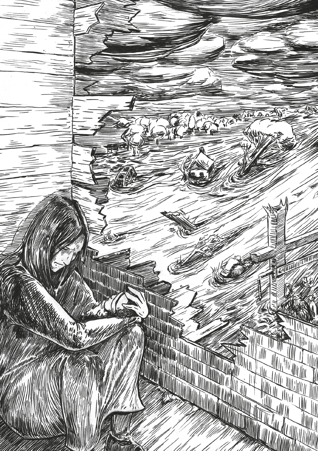
Jane Hargraves cradles her infant as her house is taken by the flood. (Mike Sharp)
Where the west branch and east branch met, there was a three-arch bridge. As the wrecks of buildings, trees, and machinery piled up against it, it dammed the water up to a depth of 33 feet. If the bridge had given way, it might have spared the houses and mills nearby. The solidly built bridge unfortunately held fast, and as a result the rush of water found its way around the bridge and roared straight toward the Knowlton Mill and the mill village nearby. The mill had just been built using the latest construction technology, made entirely of solid stone, and stood three stories high. It was filled with brand new power looms. As the creek pulled the building apart stone by stone, the bell in the bell tower tolled ominously until it, too, came crashing down.
There was a silver lining to the catastrophe at Knowlton Mill, though—the timing. The mill employed over 50 workers, most of them female, who usually worked on Saturdays. But the major projects of the week had been completed and they’d all been dismissed early, so no one was in the mill when it was destroyed. The wreck of the Knowlton Mill was a battering ram, pummeling every mill, dam, and house downstream, traveling at an estimated 20 miles per hour. One of those houses belonged to the elderly John Rhoads, who lived with two of his grown daughters in the village of Rockdale. A third daughter lived nearby, and her daughter was visiting her grandfather at the time of the calamity. John, his two daughters, and his granddaughter all perished, leaving the girl’s mother alone to mourn the loss of her entire family. John, one of his daughters, and the granddaughter were found two miles downstream. The other daughter was found near Marcus Hook, having been washed down the entire length of the Chester Creek into the Delaware River.
In a home near to that of John Rhoads, Mary Jane McGuigan drowned along with her infant child. The infant child was only discovered six months later, buried in a deposit of earth. Her mother was never found. Another neighbor of John Rhoads was Samuel Riddle, who was at work at his factory during the flood, and the second floor of his home became the refuge of 13 terrified young women. Though the house rattled, and the women could hear the shrieks of the Rhoads and McGuigan families as they died, a large tree in front of the house took the brunt of the debris, deflecting it around the Riddle home. All 13 women survived.7
As the sun rose on August 6, 1843 the general emotion was shell-shocked desolation. In the following days, the discovery that the catastrophe had occurred almost entirely within Delaware County (the nearby Brandywine Creek, which was almost always the first to flood, had been minimally affected) caused people to wonder why they had been singled out. The report stated, “Our little county appears to have been destined in a peculiar manner, to bear nearly the whole brunt of the calamity. The shock was so sudden and so violent, that for a few days the people stood aghast, almost ready to believe that their county had been overwhelmed in irreparable ruin.”8 Twenty families saw their homes entirely destroyed; more than 100 other families lost their furniture, clothes, tools, and worldly possessions. The people of Delaware County quickly mobilized to care for the homeless, and donations arrived from Philadelphia and Chester to purchase the necessities for those affected, including over 400 children. Eight factories, two flour mills, three saw mills, two paper mills, and more than 20 other buildings had been obliterated. Countless others were heavily damaged. Fifty-three mill dams were destroyed, rendering those mills that still stood—which had been powered by the water flow from these dams—unusable. Thirty-two of the county’s bridges were wholly or partially destroyed, disrupting transportation for years.
The most tragic legacy of that night was the loss of life. Nineteen people, most of them children and young adults, were drowned or killed by debris. That number could have been far worse, had the flooding happened at night when people were asleep in their beds, rather than in the late afternoon when the sun was still up.
The longest-lasting effect of the flooding was the almost complete destruction of farming and agriculture along the four affected creeks, as rocks, gravel, sand, and debris replaced fertile farmland. In many places it would take years for enough grass to regrow to even pasture animals. A seven-foot-wide boulder near Radnor was moved several hundred yards down Ithan Creek; millstones weighing 2,000 pounds from mills upstream on Chester Creek were found at mills downstream. A 1,700-pound iron boiler was swept from Crozer’s factory on Chester Creek and ended up lodged in a mill dam a mile away, filled with gravel and sand. A massive amount of sand and silt carried by the four creeks ended up in the Delaware River, causing concerns about needing to dredge the waterway to allow ships to reach Philadelphia.
The flood claimed its last life two days after the disaster, when tenyear-old Reuben Yarnall, Jr. of Edgmont went wading in his usual spot in the Rocky Run (a tributary of Chester Creek), only to drown when he discovered that the normally 18-inch-deep run had been excavated by the rushing water to a depth of eight feet—and he couldn’t swim.
The flood of August 5, 1843 was historic and inexplicable—a fact which led the Delaware County Institute of Science to appoint a committee to conduct interviews, compile information, assess damages, and answer the big questions of why and how. Appointed to the committee were Minshall Painter of Middletown Township, a printer and avid natural scientist who with his brother Jacob founded a botanical garden that later became Tyler Arboretum. Also on the committee was John Price Crozer, a textile manufacturer whose factories had been damaged in the Chester Creek flooding (his mill was the one that lost its iron boiler). Crozer would go on to fund the Normal Institute for Boys, which later became the Crozer Theological Seminary where Martin Luther King, Jr. attained his Bachelor of Divinity degree. The final member of the committee was Dr. George Smith, a physician, state senator, and landowner in Darby who 20 years later would go on to write The History of Delaware County.
The committee concluded their report by blaming the ferocity of the flood on the interference of humans who built bridges and other obstacles that prevented the natural diffusion of the water over meadows and fields. Clearing timber for fields and building exacerbated the problem by essentially creating a racing strip where water could build up deadly velocity over long distances—and the danger of flooding would only get worse with time and further development. This report became one of the first American environmental warnings about the toll that human activity takes on natural meteorological events.
On August 7, 2019, almost exactly 176 years after the greatest flood in Delaware County history, a powerful storm struck the same geographical area. It started around 3pm and ended around 7pm, just like the storm in 1843. It unleashed four to eight inches of rain in those four hours and spawned several whirlwinds that whipped through Delaware County, twisting trees off midway up their trunks and leveling a straight swath of damage for several miles. Over one hundred lightning strikes were recorded along the I-95 corridor through Chester and Delaware Counties. Hundreds of residents were affected by the flash flooding and water rescues that followed, and dozens of buildings were flooded.
Many residents recalled it being the worst storm they’d seen in their lives; one man described the event in these terms: “The skies opened up and sucked in the world.”9 One can only imagine the emotions of that night almost exactly 176 years earlier—without warning, without understanding, and utterly without mercy.
Notes
1Benjamin Franklin writing as Richard Saunders, An Almanack For the Year of Christ 1735 (Philadelphia: B. Franklin, 1734), https://founders.archives.gov/documents/Franklin/01-02-02-0001.
2William K. Klingaman and Nicholas P. Klingaman, The Year Without a Summer: 1816 and the Volcano that Darkened the World and Changed History (New York: St. Martin’s Press, 2013), 89.
3William Penn to Lord North, 1683. Quoted in Ben Gelber, The Pennsylvania Weather Book (New Brunswick, NJ: Rutgers University Press, 2002), 17.
4Delaware County Institute of Science, Report of a Committee of the Delaware County Institute of Science, on the Great Rain Storm and Flood, which Occurred in That County on the Fifth of August, 1843 (Chester, PA: Y.S. Walter, 1844), 16.
5Ibid., 19.
6Ibid., 41–42.
7Ibid., 45–46.
8Ibid., 33.
9William Boggi quoted by Trang Do (@TrangDoCBS3), “‘The skies opened up and sucked in the world. It was crazy.’ William Boggi snapped a picture of a minivan teetering on the edge of a sinkhole that opened up outside of the Giant in #Broomall after last night’s storms …,” Twitter post with photos, August 8, 2019, https://twitter.com/TrangDoCBS3/status/1159407055737954304.