
A cosmic observer, privileged to look down on the world of the fifteenth century from a commanding height, would have noticed a number of cultures and civilisations separated by great distances, poor communications and, in some cases, mutual ignorance or lack of interest. He might, however, have detected — in places, for the most part, outside Latin Christendom — some stirrings at the edges: the dilation of political frontiers or the beginnings of movements of expansion, of settlement, trade, conquest and proselytisation, which would make the world of the next few centuries an arena of imperial competition where expanding civilisations collided and where virtually all human communities were joined in conflict, commerce and contagion. The accomplishment of this enormous and conspicuous change depended on the creation of practical routes of access between previously isolated or barely-communicating groups of people.
In these pages, ‘exploration’ is understood to mean the identification, investigation and recording of such routes. The process came to be dominated by explorers from Latin Christendom. Yet our hypothetical observer, unless also endowed with foresight, would probably not have been able to predict such an outcome until the century was well advanced. Such sources of motivation as material exigency, scientific curiosity, missionary zeal, commercial spirit or wanton aggression were not peculiar to any one part of the world, and, compared with China and Islam, Latin Christendom was underequipped in the technical resources with which to undertake long journeys, to sustain life during them, to find directions in unfamiliar places, to record and communicate the information gathered.
Some otherwise promising cultures were subject to even greater technical limitations which perhaps inhibited or disqualified them from further big achievements in exploration. Among the Aztecs and their neighbours, for instance, as among the indigenous peoples of sub-Saharan Africa, there was no means of long-range navigation by sea; in Peru, no maps. The Polynesians, surrounded by the vast Pacific, may have attained the limits of the world accessible to them with the technology at their disposal. Yet the record of these societies from which routes were explored and recorded over vast distances — extending in the Peruvian case across thirty degrees of latitude and in the Polynesian case over thousands of miles of sea — shows how much can be achieved in defiance of technical insufficiency.
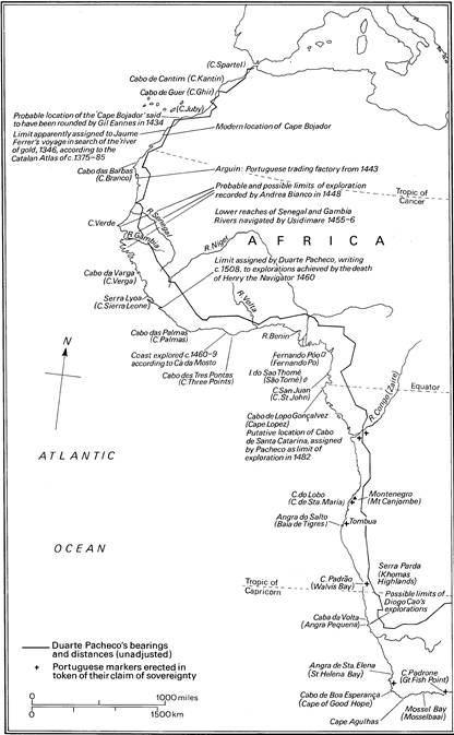
Map 3 The extent of European discoveries on the west African coast
The best-equipped people, indeed, failed to fulfil their promise as explorers. Java, for instance, probably had by the late fourteenth century cartographical traditions and shipbuilding techniques at least as good as those of anywhere else, but all her shipping was absorbed by the demands of trade within a fairly restricted zone between south Asia and the far east. By the mid-fourteenth century, Arabic travel literature and pilgrims’ guides covered the whole Islamic world and extended selectively beyond it, for instance, into Sardinia and China; and Arabic sailing directions of the second half of the fifteenth century covered the Indian Ocean from southern Africa to the South China Sea. Yet after the Arab commercial world had attained its desired limits in the Mediterranean and the far east, Islamic exploration further afield became fitful and slight. In particular, little attempt was made to imitate the achievements of Indian Ocean navigators in Atlantic waters, and mariners satiated with the profits of well-known routes showed no inclination to venture beyond the stormy latitudes which screen the Indian Ocean to the south. When the New World became an extension of Christendom and the Portuguese discovered an Atlantic highway to the east, the Ottoman sultans came, too late, to regret their failings.
Meanwhile, development of the exploring traditions of China was similarly arrested. The range of travel had long been limited to the reach of trade and diplomacy; but in China that meant including a huge swathe of the world, exceeding the length of the silk roads and the breadth of the Indian Ocean. Geographical scholars collated and mapped the information collected. In about 1220, for instance, a detailed account of the South China Sea and of countries of south-east Asia and India was produced, partly from personal observation, by a scholar and diplomat. A century later, passable maps of the Indian Ocean were made, perhaps including the coast of Africa to beyond the Cape of Good Hope. Between 1405 and 1433, a series of tribute-gathering missions under the eunuch-admiral, Cheng Ho (Pinyin: Zheng He), consolidated knowledge of commercial routes and reported, from direct experience, on places as distant as Jiddah and Malindi. Yet for a combination of imperfectly understood reasons — which included the effects of the ebb and flow of factional conflicts, the hostility of the mandarin elite to eunuchs and traders and the prohibitive cost of the ventures — this potentially imperial initiative was aborted. Naval shipbuilding was discontinued and many official records of Cheng Ho’s achievements were destroyed.
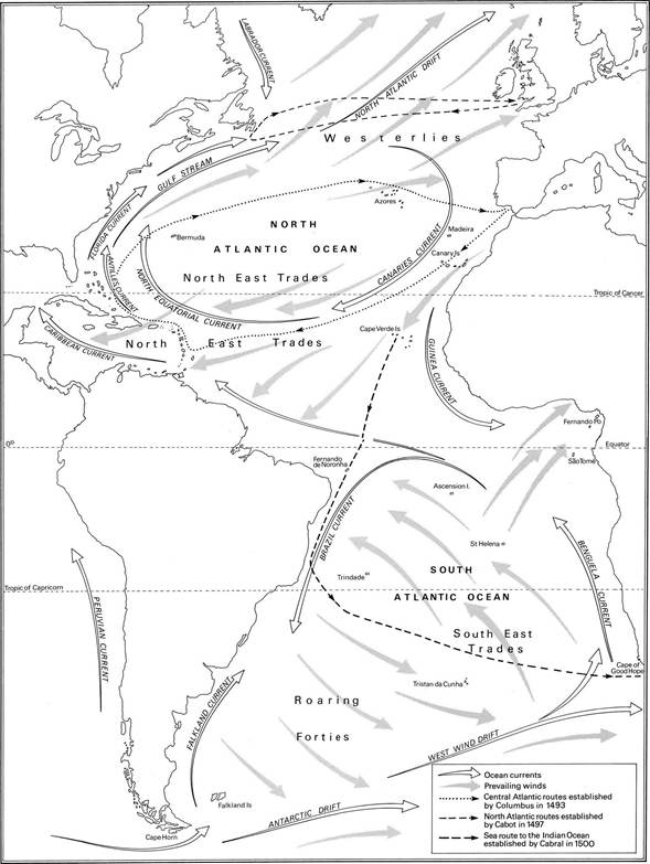
Map 4 Winds and currents facilitating the discoveries
Thus while more prosperous and proficient civilisations rested content with the exploitation of their traditional contacts, it was left to explorers from Latin Christendom to search for new resources, extend their reach and ultimately enmesh most of the world in their routes. Their biggest source of advantage was probably their starting-place on the edge of the Atlantic. In the age of sail, maritime route-finding depended on access to favourable winds and currents. Navigators from the Indian Ocean and western Pacific would not have found conditions favourable for long-range navigation outside the zone of monsoons, even had they wished to do so. The only navigable route eastwards across the Pacific was an effective dead end until trading-places developed on the west coast of America in colonial times. The ways out of the Indian Ocean to the south were laborious and dangerous and led, as far as was known, only to unrewarding destinations.
The Atlantic, by contrast, was a highway to the rest of the world. Its wind systems provided potential links with the Pacific and Indian Oceans as well as routes between the Old and New Worlds. The location and exploitation of these routes was a labour, accomplished in the fifteenth and sixteenth centuries, which deserves its reputation as a revolutionary achievement in world history. Though there were episodes of interest or importance in other parts of the world, the story of exploration in the fifteenth century is very largely of the crossing of the Atlantic with routes that linked its shores and led to other oceans.