Part II
Chapter 11
Rome and Italy
The origin of the Roman Empire was its capital, Rome, where a cluster of several little hilltop settlements joined together to form an urban centre during the eighth and seventh centuries BC, and then gradually incorporated the surrounding countryside of Latium. Rome was located at a key point in central Italy, on the lower Tiber, approximately 25 km from the coast. It was situated not only at a major river crossing, but also at a trade junction where the Salt Road (via Salaria) running from the coast to the Sabine hinterland crossed the north–south route between Etruria and Campania. Accordingly, a trade forum developed early on the banks of the Tiber: the cattle market (forum Boarium), where fragments of Greek vessels are among the finds dating back to the eighth century BC. In addition, a central meeting square, the forum Romanum, was built for the emerging community of citizens at the foot of the Capitol, where the main municipal shrine, to the god Jupiter, was located (see Fig. 22 below).
After the expanding city was put to the torch by the Gallic Celts in 387 BC, an 11 km long fortified wall, the so-called Servian Wall, was built around it a few years later. This encompassed an area of 426 ha, which became ever more densely populated over time. Since the city had grown organically, it had no rectangular street grid; the roads to the countryside emerged from Rome like rays. After the food merchants had been expelled from the forum Romanum in the late fourth century BC, the square in the third and second centuries BC changed further into a political and administrative centre, with prestigious temples and basilicas. By the early and middle republican period, the city had developed into the leading economic and political nodal point in central Italy, although at that time it had only a river port, for the seaport of Ostia would not be built until the middle of the first century AD, under Emperor Claudius.
Rome's geographical position held both opportunities and perils. Despite its central location, the city was also peripheral to both the Etruscan and Latin areas. Rome, with its initially modest surrounding countryside, was a city state in Latium dominated by noble families, and was constantly forced to defend itself against mountain tribes seeking new settlement lands on the coast. In this struggle, however, Rome itself displayed expansionist tendencies, and took over neighbouring territories. By 400 BC the nearby Etruscan city of Veii had been conquered and incorporated into Roman territory – the beginning of a continuous expansion of the city's domain which was to bring access to the resources of the wooded Apennines and the fertile fields and pastures of central and southern Italy. By 270 BC all of Italy south of the Po was subject to Rome. Expansion beyond Italy was now only a matter of time.
By the end of the republican period, Rome had grown into a metropolis of some one million inhabitants, for whom a considerable infrastructure was provided. However, the Romans not only developed many new settlement areas, but also became acquainted with the numerous problems of a major city – traffic, noise, and the stench of waste and of open fires. These problems also started to appear at numerous other places in the empire.
The Roman Empire
Roman expansion led to a massive transformation of the Mediterranean area by the first century BC. The Roman conquest of Italy was followed by the expansion to Sicily and then to other areas of the western and eastern Mediterranean, where Roman provinces were set up in succession: Sicily, Sardinia and Corsica in 227 BC, Spain in 197 BC, Macedonia and Greece (Achaea) in 148–146 BC, Asia (Minor) in 129 BC and Egypt in 30 BC. In 15 BC the first Roman emperor, Augustus (27 BC to AD 14), launched the Alpine campaign, the beginning of the conquest of northern Europe, in which Rome pushed its boundaries to the Rhine and the Danube. In the east the Euphrates was the boundary, so that the empire embraced a gigantic territory of over 50 million inhabitants. Further advances beyond these rivers, as well as to Britain, were yet to follow.
In his Geschichte der Landschaft in Mitteleuropa, Hansjörg Küster in 1995 pointed to the extensive changes which took place in southern central Europe as a result of its incorporation into the Roman Empire. For the first time the agricultural areas and resources of the area north of the Alps were intensively utilised. South-central Europe was clearly bounded by the Rhine and Danube, and within this area the essential features of a uniform culture could develop. Here were settled a large number of people – how many is unknown – who knew how to farm the land with new methods. Urban settlements, ports, road networks and manors with intensive animal husbandry, farming, orchards and pastures arose. Vineyards and wheat farms were introduced to the area, and figs, spices and oil were imported from the south. The forests of the north were used for the first time on a large scale for timber construction. In Germany, which Tacitus described as a country of fearsome forests and dismal swamps (Germ. 5.1), the Romans had access only to a small portion of the country.
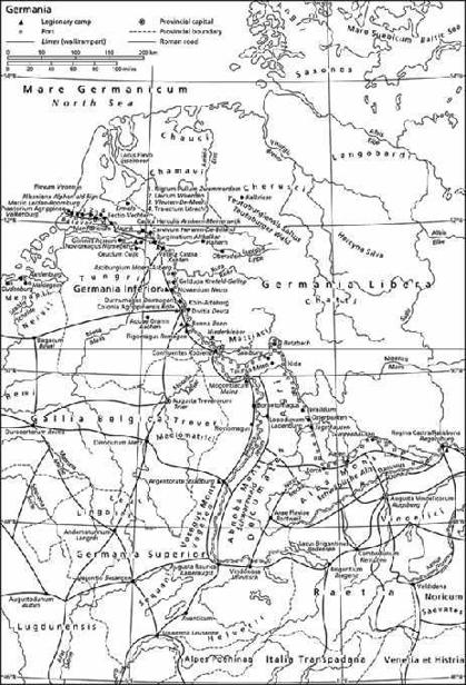
The land was developed through road-building, parcelled out by ‘limitation’ (surveying and construction of boundary paths crossing at right angles), and allocated or leased to Roman citizens. The spectrum of the settlements ranged from existing native towns raised to municipia, through newly established Roman citizen cities (coloniae) and little settlements on key transport routes (vici/villages), to manors (villae) scattered throughout the country. Cities were often built on the slopes above rivers or at the confluence of two or more rivers – Coblenz and Passau in Germany, or Augst and Windisch in Switzerland – while the villas tended to be built in neighbouring loess areas (Fig. 11).
Fig. 11 Roman Germany: settlements, the road network, the Rhine boundary and the limes.
Despite the intensive land use and forest clearing in Roman times, the ancient impacts generally took place in relatively modest dimensions and were in some cases compensated by new tree planting or by reafforestation. As we will see, in the Main–Danube area of Württemberg, for example, sediments caused by increased flooding can be ascertained for the first to the third centuries AD, with oak logs embedded in it; only in post-Roman times did new floodplain forests grow back. The imperial spatial development, with its dense road network, which has to some extent survived into modern times, also had long-term effects.
The Roman roads
Roads provide information not only about political, military and economic contexts, but also about the manner in which a society overcomes distance and controls its space. In the Near East the Assyrians already had an extensive road network in the eighth and seventh centuries BC, which was later expanded still further by the Persians (Achaemenids), for whom it served the administrative and military consolidation of their huge empire. Unlike the Greeks, the Etruscans at an early stage already had city streets and roads in Italy. Marzabotto near Bologna had a right-angled street grid in the fifth century BC, with drainage trenches on both sides.1
Starting with the construction of the via Appia in 312 BC, the Romans gradually developed a far-flung road network, with an ultimate length of 80,000 to 100,000 km, running throughout their realm. Starting in 15 BC, the Alpine area too was tied into the road network. The route across the Little St Bernard Pass connected the Aosta Valley in north-western Italy with Lugdunum (Lyon) in the Rhone Valley, while the road over the Great St Bernard linked that area to Lake Geneva and Augusta Raurica (Augst near Basel) in the upper Rhine area of northern Switzerland. The via Claudia Augusta led over the Reschen Pass from Bozen/Bolzano in northern Italy to Augsburg, while a parallel route crossed the Brenner Pass. Another route across the Alps ran from Augsburg via Kempten and Bregenz on Lake Constance to Chur in eastern Switzerland, and from there across any of several Grisons passes, such as the San Bernardino, to northern Italy (Fig. 11).
The roads served the army for troop movements and resupply, the merchants and traders for the transport of goods, and the imperial administration for the rapid dispatch of messengers. Augustus founded the cursus publicus, a state courier and transport system which included the provision of official trips at public expense. Local people were required to make state messengers, transport carts and draught animals available, for which they were, however, compensated.2
The roads were mostly built by army troops and ran as straight as possible, or else along old routes or mule tracks. The goal was to avoid having to build such structures as arched bridges, tunnels, causeways or cliff-retention supports, which were expensive and time-consuming. Generally, roads were not built in valley bottoms, which were prone to flooding, but rather on the sides of valleys or along ridges. Paved streets existed largely in the cities and near settlements, but country roads too were sometimes paved. The more common gravel roads could be built faster and repaired more easily. They were built on a reinforced underlayer and lined with border-stones. Milestones (miliaria), roadside stone columns 2 to 4 m high, marked the distances.3
Typical travellers included business people, traders, troops and other army people, magistrates, couriers of the cursus publicus, statesmen and even the emperor himself. Private persons took trips to the baths at Baiae on the Gulf of Naples, made educational journeys to the philosophers’ schools in Greece – Cicero visited Athens, and Julius Caesar, Rhodes – and visited shrines such as Delphi and Olympia, and natural scenic sites such as the Tempe Valley in Thessaly or the grotto at Parnassus. Egypt was the destination of dreams.4 Even if mass tourism did not yet exist in antiquity, a critique of tourism already did – from the philosophers. On the one hand, journeys were seen as healthy hardships which made the traveller tough – a beneficial restriction to simple food and lodging, which strengthened body and soul – on the other, criticism was directed at extreme luxury of travel and ceaseless restlessness (Sen. epist. 87.2ff., 104.13ff.; tranq. 2.13ff.).
Journeys were taken on foot – for the rich, that meant in a litter – in the saddle, usually on a donkey or mule, rarely on a horse, or by wagon. Overnight accommodation was provided by inns (mansiones), and changing stations (mutationes) exchanged draught animals and repaired vehicles. In land transport, oxen and horses, donkeys and mules were used as beasts of burden or harnessed to draw two- and four-wheeled wagons.5 Bulk goods and heavy loads were transported by water, on the rivers or by sea. The extensive transport network which made possible the exchange of goods over long distances led both to the import of new products and to the specialisation of traditional production centres and agricultural landscapes. Roman roads were in any case in use until well into the Middle Ages, and have been repeatedly repaired and in some cases used to this day. They thus contributed significantly to the development and integration of western Europe.
1 Schneider 1982, 4ff.; Giebel 2000, 35–6, 131–2.
2 Kolb 2000, 123ff.
3 Schneider 1982, 29ff., 102ff.; Bender 1989, 115ff.
4 Casson 1974, 229ff., 257ff.; Giebel 2000, 197ff.
5 Bender 1989, 142ff.