Chapter 22
The environmental history of antiquity concerns not only the Greek and Roman world as a whole; local studies, too, are particularly important, and can therefore be applied very well to smaller regions or to single provinces. I would therefore like to conclude this study with a look at Roman Britain, regarding which a number of the topics touched on above have been thoroughly examined, and can be discussed in an exemplary overview.
The geographic space
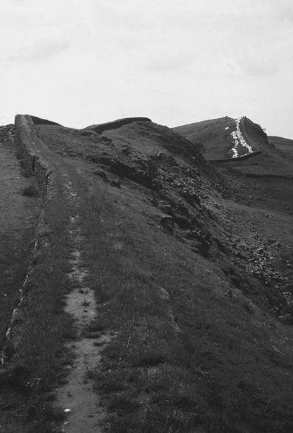
After the first attempts at landings by Caesar in 55 and 54 BC, the island of Britain was already coming under Roman influence, but its conquest did not begin until AD 43 under Emperor Claudius, who occupied large areas of what is today southern and central England and also Wales; it ended in AD 83/4, under Emperor Domitian, when the governor Agricola defeated the north British army at Mons Graupius and declared the line of the Firth of Clyde and the Firth of Forth as the northern boundary of the province. InAD122, having suppressed a rebellion by the native Brigantes in 118/19, Emperor Hadrian built the so-called Hadrian's Wall between the Tyne and the Solway Firth, with a total length of 118 km. The so-called Antonine Wall, which moved the boundary northward to the Clyde–Forth line for four decades, was built under governor Q. Lollius Urbicus in AD 139, and marked the maximum extent of Roman territory in Britain (Figs. 24 and 25). Further attempts to push deeper into Scotland at the beginning of the third century ADleft behind temporary marching camps which can still be seen from the air, but ultimately ended in failure.
Fig. 24 The principal military installations and main civilian settlements in Roman Britain.
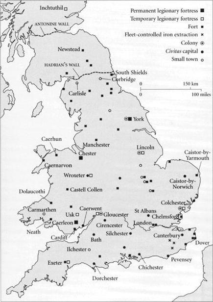
Fig. 25 Hadrian's Wall at Housesteads (Vercovicium).
Thus, in spite of these periodic thrusts into Scotland, the Romans never occupied the entire island of Britain; nonetheless, even the borders they established in the north constituted two major intrusions into the landscape. On the one hand, the construction of the walls took advantage of geographical features and a military road built by Agricola between the east and the west coast, the so-called Stanegate. On the other, it also cut through farming areas with no consideration for existing divisions of fields; moreover, tons of turf were cut out for the construction of the wall and its trenches. Furthermore, huge quantities of wood and stone were used, for which purpose adjacent forests to the north were clear-cut, and local quarries, such as Barcombe Down near Vindolanda, exploited.1
Geographically, Britain is generally divided into a northern highland zone and a southern lowland zone, separated by a line running from the mouth of the Exe in the south-west to the mouth of the Tees in the north-east. The highland zone is climatically cooler and wetter, and therefore better suited for livestock raising, while the more fertile lowland zone, with its loam and clay soils, has largely been used for agriculture. However, no strict separation between these two zones is useful here, for one can also identify an intermediate central zone running across the island, which was indeed especially fruitful. At any rate, the Romans profited from a favourable climatic period during the time of their occupation (AD 43–410). Isotopic and botanical data such as tree rings have revealed that the European climate was already getting drier and warmer during the second century BC; then, during the period from 100 BC to AD 250, optimal conditions prevailed overall. As of the middle of the third century AD, the climate in Britain became colder and wetter again, which led to increased flooding. Then, started around AD 400, a major cool spell set in, dropping temperatures by an average of almost 2 degrees and bringing approximately 10 per cent more precipitation.2
Accordingly, as of the third century AD, particularly in the southern Fens, the bog landscape around the Wash, flooding increased along the coasts, in part, too, due to the slowly rising sea level. At the same time, there were inland floods on rivers, which carried increased sediments, so that numerous farms had to be abandoned.3 The causes were both deforestation and erosion, and also poor drainage. Here the agricultural and silvicultural activities intensified by the Romans seem to have had a negative effect in deteriorated climatic conditions; however, this cannot be considered the reason for the fall of Roman rule.
Agriculture, forestry and industry
The Romans had found large areas of fertile arable land in Britain, and also continued to exploit the mineral resources which had already been mined during the Bronze Age, for export to the Mediterranean. Clearing of forestland had already taken place during the Celtic Bronze Age, especially in southern England and Wales, so that the Romans had considerable cultivated land available to them. However, they now undertook additional clearing, particularly in northern England and the area around Hadrian's Wall, and opened up new arable land in higher lying areas, while the forests in eastern Scotland north of the Antonine Wall were able to recover and regenerate.4 Moreover, the Romans improved both agriculture and livestock breeding of various animals, including cattle, pigs and sheep,5 and introduced new varieties, including the white-fleeced woolly sheep and – a pest – the black rat. Agriculture was improved and expanded in new areas, primarily by drainage and the introduction of the iron mouldboard plough. However, these new areas were increasingly vulnerable as the climate deteriorated, and especially in the highlands became ever less farmable. Around AD 400, clearing was discontinued, and numerous fields abandoned, so that scrub spread, and in some areas the forests could partially recover and expand anew.6
During the republican period Britain had been seen as a climatically cold and densely populated country (Diod. 5.21.6), although Caesar (Gall. 5.12.6) described the climate as relatively mild. It was famous for its cattle and cereals, which were exported to the Rhine up to late Roman times (Amm. Marc. 18.2.3). Its metal resources too were sought after, particularly tin in Cornwall (Diod. 5.22), and also iron, lead with silver – obtained in open-cast mining – copper and gold; furs, slaves and dogs, too, were exported (Strab. 4.5.2). Tacitus, Agricola's son-in-law in the early second century AD, again described the climate as unpleasant – rainy and foggy, though not extremely cold, so that the soil seemed fertile and suitable for all plants except wine and olives (Agr. 12). These were imported, like other Mediterranean foods such as figs and fish sauce, though grapes were occasionally planted in the south of the island (for example, Boxmoor, Hertfordshire). Moreover, new vegetables, such as cabbage, peas and carrots; fruits, such as apples, plums, cherries and walnuts; and flowers, including roses, lilies, violets and poppies, were introduced to the island.7 The main cereals in Britain became spelt wheat and barley, together with bread wheat, rye and oats, the varieties of which were further improved.8All in all, it appears that the food supply and diet were good, as examinations of skeletons also indicate.9
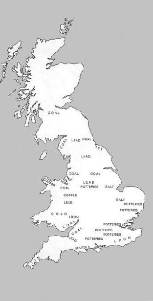
In addition to foodstuffs, valuable manufactured goods of glass or ceramics, such as Samian ware (terra sigillata) from Gaul, as well as of metal and marble, came to the island. However, the indigenous glass and ceramic production gained increasingly in importance, as shown particularly by the numerous kilns and the mountains of waste in Nene Valley. Moreover, salt was panned on the coasts, and coal mined for heating in the central and western regions (Fig. 26). Gold was mined only in Wales, where huge quantities of water were piped in through three aqueducts for the stepped washing areas in Dolaucothi, Carmarthenshire. The local iron-smelting left gigantic slag heaps in the Weald, Sussex, at Weston-under-Penyard (Ariconium), Herefordshire, and in the Forest of Dean in Gloucestershire; they must have caused considerable air and groundwater pollution.10
Fig. 26 Main mining areas and products in Roman Britain.
Metals could easily be exported by sea from the southern coast, Cornwall and Wales. There were also many river connections to the interior, which were supplemented by an extensive road network for the exchange both of troops and of goods. Many Roman roadways cut through the landscape on a straight line, and can in some cases still be recognised today. Inns, market towns and small villages were built along the roads and at crossroads. The island was developed anew by improved infrastructure, which also increasingly benefited the balance of trade.
Military camps, cities and villas
The population of Roman Britain is estimated at approximately 3.5 million, including some 50,000 Roman soldiers.11 They constituted one of the strongest provincial armies, and were established in various legion forts – Caerleon, Chester, York and also Gloucester, Wroxeter and Lincoln – as well as in numerous smaller forts along the coast and in the interior (Fig. 24). They carried out not only military services, but also all kinds of craft work. The settlements and the numerous trades they contained moreover produced a large amount of waste, which polluted the local environment.
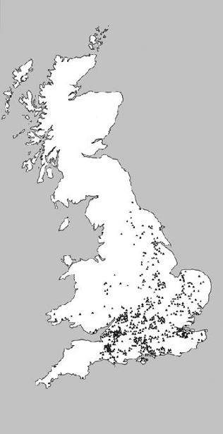
A number of new civilian cities also emerged in connection with the Roman forts: with rectangular street grids, public buildings and squares, and water mains and baths, they served both the local market and the Roman administration. The seat of the governor was originally in Camulodunum (Colchester) and was moved during the first century AD to Londinium (London), which, with its approximately 30,000 inhabitants, was the largest city and, with its port, also an economic centre. A total of only four new Roman colonial cities were founded – Camulodunum, Glevum (Gloucester), Lindum (Lincoln) and Eboracum (York) – so that Celtic rural village society, divided into civitates, was only partially replaced by urban development. The only already existing settlement orCeltic tribal centre (oppidum) to explicitly be reported as having been transformed into a Roman municipium is Verulamium (St Albans; Fig. 24). In the countryside it was mainly in the lowland zone – except for Wessex – that rectangular Roman villas were next to, or on the ruins of, wooden Celtic roundhouses (Fig. 27), ranging from modest country houses (cottages) with a few rooms in a line, through winged corridor houses, to mansions with three- or four-sided courtyards, which in a few cases, such as that found in Fishbourne, attained palatial dimensions.
Fig. 27 Distribution of villas in Roman Britain.
Despite the crises of the fourth century AD, Britain was still an attractive target for plunder and settlement for foreign tribes. These included on the one hand the Picts in Scotland and the Scots of Ireland, and on the other the Germanic tribes – the Saxons, Franks and Angles. After the Roman troops were removed from the island in AD 401/2 for the defence of Italy, the fortifications previously established on the southern and eastern coasts, the ‘Saxon Shore Forts' (litus Saxonicum), were ultimately ineffective. Thus, many Roman facilities crumbled, and the country was used in new – or resurrected old – ways. Nevertheless, the foundations for an urban landscape with a new infrastructure networked nationwide had been laid, from which later epochs were able to profit, despite the damage that had been caused to the environment.
1 Breeze 1993, 73ff., 102ff.; Dark and Dark 1997, 33ff.; Pearson 2006, 16ff., 46ff.
2 Jones 1996, 187ff., esp. 197, 220; cf. Lamb 1981; Dark and Dark 1997, 18ff.; Chapter 1, nn. 6–7, above.
3 Jones 1996, 197ff.; cf. Jones and Mattingly 1990, 7ff.; Pearson 2002, 99ff.
4 Dark 1999, 264ff.; 2000, 100ff., 128.
5 A. Grant, ‘Domestic Animals and Their Uses’, in Todd 2004, 381.
6 Jones 1996, 226–7; Dark and Dark 1997, 143–4.
7 Scullard 1979, 125–6; Alcock 2006, 127–8; van der Veen et al. 2008.
8 Dark 1999, 264; 2000, 85.
9 C. Roberts and M. Cox, ‘The Human Population: Health and Disease’, in Todd 2004, 248ff.
10 Jones and Mattingly 1990, 179ff.
11 Jones 1996, 208ff.
Conclusion
The environmental history of antiquity covers a wide range of fields of analysis of living conditions in ancient Greek and Roman times, and can thus claim relevance for the characterisation of an entire epoch. It shows both continuity of the landscape and changes in the Mediterranean area and the adjacent regions to the north, from the early part of the first millennium BC through late antiquity in the fourth and fifth centuries AD. It leads from the modest beginnings of the world of the polis in Greece, which spread across extensive areas around the Mediterranean and Black Seas, to the Roman Empire, with its vast territorial expansion that resulted not only in the conquest of the countries bordering the Mediterranean, but also embraced areas north of the Alps, so that large portions of European territory were opened up to settlement and economic activity. This intensified settlement laid important foundations for the shaping of medieval and hence also of modern Europe. The conceptualisation of nature developed by the Greeks and Romans, and their manner of dealing with their natural environment, would also have after-effects.
A study of the environmental history of antiquity is restricted primarily by the sources, since the literary reports are limited in scope and often provide only a one-sided view of the situation; they can only partially be completed or corrected by the results of natural-scientific investigations. There are no detailed descriptions of the environment, or of environmental problems. Environment in the modern sense was only described at a general level, primarily in terms of such climatic factors as wind and water. Despite the religious respect for nature, it was always seen as a challenge to be mastered and defeated by technical means. Such threatening elements as fires, floods, earthquakes and volcanoes, and also drought and wind storms were to be brought under control. Human destruction of nature, exhaustion of resources and the harmful effects of pollution were noted and criticised, but largely as a critique of opulence, and with no clear analysis of the issues.
Land and resource exploitation had already led to local environmental damage among the Greeks. The impacts of the Romans were of a similar nature, to some extent quantitatively increased; moreover, they covered a greater geographical area. From the outset, the central factors for all regions was agriculture and spreading urban development. Nature was systematically used, without this, however, resulting in any agricultural technological revolution. The soils were over-exploited, forests were clear-cut, river and lakesides built up and obstructed, bodies of water artificially transformed and polluted, animals exploited and harvests destroyed in war. The results, in many places, were environmental damage or soil erosion and decimation of plants and animals. Gardens clearly served the purpose of basic food production, both in the countryside and in the cities and their immediate surroundings, but were also built for their aesthetic qualities, as an element of a luxurious lifestyle. Urban development led to problems of residential hygiene, and made measures against waste, air pollution, noise, fires and traffic necessary. Land parcelling and opening up of large areas of land with roads made it possible for the Romans to build an extensive economic network for the exchange of their goods over long distances. Local specialisation developed, and exogenous plants and animals were introduced in new areas. Roman food products spread across large portions of Europe, although regional differences were still maintained.
The countryside of Europe had changed markedly in many areas, and had both opened up new horizons for people, and also shown them limits of use. Since total populations were still limited, and the extent of overall damage remained relatively slight, or correctable, no comprehensive criticism of the handling of the environment arose. Nevertheless, measures to limit damage and also to protect and preserve resources were indeed initiated by the state. That enabled crops, trees and forests to be restored, albeit often in changed form, and bodies of water and drinking water to be provided to the general public on a long-term basis. Both individuals and the community had to take at least partial responsibility for nature and its assets. Overall, a pragmatic line was pursued, which made nature and its resources available for common use, but also preserved them for the benefit of the community. Nevertheless, the extensive mining of raw materials caused permanent environmental damage, which is in some cases visible or ascertainable even today.