
Chapter 8
La Paz, the capital city of Bolivia, nestles in the uneven bottom of a spectacular hole in the ground more than two miles above sea level. This plunging ravine, thousands of feet deep, was carved in some primeval age by a tremendous downrush of water that carried with it an abrasive tide of loose rocks and rubble.
Provided by nature with such an apocalyptic setting, La Paz possesses a unique though slightly sleazy charm. With its narrow streets, dark-walled tenements, imposing cathedrals, garish cinemas and hamburger bars open till late, it generates an atmosphere of quirky intrigue which is oddly intoxicating. It’s hard going for the pedestrian, however, unless equipped with lungs like bellows, because the whole of the central district is built up and down the sides of precipitous hills.
La Paz airport is almost 5000 feet higher than the city itself on the edge of the Altiplano – the cold, rolling uplands that are the dominant topographical feature of this region. Santha and I landed there well after midnight on a delayed flight from Lima. In the draughty arrivals hall we were offered coca tea in little plastic cups as a prophylactic against altitude sickness. After considerable delay and exertion, we extracted our luggage from customs, hailed an ancient American-made taxi, and clanked and rattled down towards the dim yellow lights of the city far below.
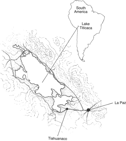
Lake Titicaca.
Rumours of a cataclysm
Around four o’clock the next afternoon we set off for Lake Titicaca in a rented jeep, fought our way through the capital’s incomprehensible permanent rush-hour traffic-jams, then drove up out of the skyscrapers and slums into the wide, clear horizons of the Altiplano.
At first, still close to the city, our route took us through a zone of bleak suburbs and sprawling shantytowns where the sidewalks were lined with auto-repair shops and scrap yards. The more distance we put between ourselves and La Paz, however, the more attenuated the settlements became, until almost all signs of human habitation ceased. The empty, treeless, undulating savannahs, distantly bordered by the snow-covered peaks of the Cordillera Real, created an unforgettable spectacle of natural beauty and power. But there was also a feeling of otherworldliness about this place, which seemed to float above the clouds like an enchanted kingdom.
Although our ultimate destination was Tiahuanaco, we were aiming that night for the town of Copacabana on a promontory near the southern end of Lake Titicaca. To reach it we had to cross a neck of water by improvised car ferry at the fishing town of Tiquine. Then, with dusk descending, we followed the main highway, now little more than a narrow and uneven track, up a series of steep hairpin bends and on to the shoulder of a mountain spur. From this point a contrasting panorama unfolded: the dark, dark waters of the lake below appeared to lie at the edge of a limitless ocean drowned in sombre shadows, and yet the jagged peaks of the snow-capped mountains in the distance were still drenched in dazzling sunlight.
From the very beginning Lake Titicaca seemed to me a special place. I knew that it lay some 12,500 feet above sea level, that the frontier between Peru and Bolivia passed through it, that it covered an area of 3200 square miles and was 138 miles long by about 70 miles wide. I also knew it was deep, reaching almost 1000 feet in places, and had a puzzling geological history.
Here are the mysteries, and some of the solutions that have been proposed:
1 Though now more than two miles above sea level, the area around Lake Titicaca is littered with millions upon millions of fossilized sea shells. This suggests that at some stage the whole of the Altiplano was forced upwards from the sea-bed, perhaps as part of the general terrestrial rising that formed South America as a whole. In the process great quantities of ocean water, together with countless myriads of living marine creatures, were scooped up and suspended among the Andean ranges.1 This is thought to have happened not more recently than about 100 million years ago.2
2 Paradoxically, despite the mighty antiquity of this event, Lake Titicaca has retained, until the present day, ‘a marine icthyofauna’3, in other words, though now located hundreds of miles from any ocean, its fish and crustacea feature many oceanic (rather than fresh-water) types. Surprising creatures brought to the surface in fiishermen’s nets have included examples of Hippocampus (the seahorse).4 In addition, as one authority has pointed out, ‘The various species of Allorquestes (hyalella inermis, etc.) and other examples of marine fauna leave no doubt that this lake in other periods was much saltier than today, or, more accurately, that the water which formed it was from the sea and that it was damned up and locked in the Andes when the continent rose.’5
3 So much, then, for the events which may have created Lake Titicaca in the first place. Since its formation this great ‘interior sea’, and the Altiplano itself, has undergone several other drastic and dramatic changes. Of these by far the most notable is that the lake’s extent appears to have fluctuated enormously, indicated by the existence of an ancient strandline visible on much of the surrounding terrain. Puzzlingly, this strandline is not level but slopes markedly from north to south over a considerable horizontal distance. At the northernmost point surveyed it is as much as 295 feet higher than Titicaca; some 400 miles farther south, it is 274 feet lower than the present level of the lake.6 From this, and much other evidence, geologists have deduced that the Altiplano is still gradually rising, but in an unbalanced manner with greater altitudes being attained in the northern part and lesser in the southern. The process involved here is thought to have less to do with changes in the level of Titicaca’s waters themselves (although such changes have certainly occurred) than with changes in the level of the whole terrain in which the lake is situated.7
4 Much harder to explain in such terms, however, given the very long time periods major geological transformations are supposed to require, is irrefutable evidence that the city of Tiahuanaco was once a port, complete with extensive docks, positioned right on the the shore of Lake Titicaca.8 The problem is that Tiahuanaco’s ruins are now marooned about twelve miles south of the lake and more than 100 feet higher than the present shoreline.9 In the period since the city was built, it therefore follows that one of two things must have happened: either the level of lake has fallen greatly or the land on which Tiahuanaco stands has risen comparably.
5 Either way it is obvious that there have been massive and traumatic physical changes. Some of these, such as the rise of the Altiplano from the floor of the ocean, certainly took place in remote geological ages, before the advent of human civilization. Others are not nearly so ancient and must have occurred after the construction of Tiahuanaco.10 The question, therefore, is this: when was Tiahuanaco built?
The orthodox historical view is that the ruins cannot possibly be dated much earlier than AD 500.11 An alternative chronology also exists, however, which, although not accepted by the majority of scholars, seems more in tune with the scale of the geological upheavals that have occurred in this region. Based on the mathematical/astronomical calculations of Professor Arthur Posnansky of the University of La Paz, and of Professor Rolf Muller (who also challenged the official dating of Machu Picchu), it pushes the main phase of construction at Tiahuanaco back to 15,000 BC. This chronology also indicates that the city later suffered immense destruction in a phenomenal natural catastrophe around the eleventh millennium BC, and thereafter rapidly became separated from the lakeshore.12
We shall be reviewing Posnansky’s and Muller’s findings in Chapter Eleven, findings which suggest that the great Andean city of Tiahuanaco flourished during the last Ice Age in the deep, dark, moonless midnight of prehistory.