
Chapter Four
INTRODUCTION
Freshwater is an essential element of life. Its obvious value is in the daily uses of drinking and bathing, but it is also harnessed to produce electricity, used in industrial processes, diverted to irrigate crops, and utilized by animals and plants some of which have considerable commercial value. Despite the commercial importance of freshwater ecosystems to humans throughout the tropics, their nutrient cycles, carrying capacities, and ecological limits are poorly understood.
Bodies of freshwater may be flowing (lotic) as in rivers, or more or less stationary (lentic), as in lakes and swamps. The scientists who study the living organisms of these habitats are called limnologists, and their domain actually extends beyond the lakes and rivers into the drainage basins above, features of which strongly influence the chemical composition of the drainage water. For the same reason, nutrients, dust and other particulate matter from the atmosphere which reach the earth in rain water are also considered.
The term 'limnology' was coined in 1892 by a French scientist, F.A. Forel (Cole 1983), and since that time theories and research have for the most part been conducted in temperate zones. Results from tropical limnological studies have revealed some similarities to results obtained in temperate areas, but inherent differences, particularly with respect to greater solar radiation and smaller seasonal variations, suggest that categories devised to define temperate lakes may not be applicable in the tropics (C. Fernando pers. comm.). Further, higher temperatures and a continuous growing season should theoretically support a higher rate of production, but it has not yet proved possible to devise principles that would apply to all tropical situations (Anon. 1982b).
It has been suggested that the sustainable management of freshwater ecosystems requires certain steps to be taken before and after the execution of any program that might affect them (Soerjani 1985). Those steps are:
• determine the aims and the needs of any management program (the aims are generally multi-purpose);
• make an inventory of basic information related, even loosely, to the aims and needs of the management program determined in the first step;
• gather technological knowledge related to the aims of management;
• analyse the available information in the framework of an environmental impact assessment;
• determine a plan of action, accepting the need to compensate for lost options;
• execute the plan;
• evaluate the execution and impacts within a system that is sensitive and flexible enough to allow for modifications in the management goals.
It is hoped that the information provided in this chapter will allow at least some of these steps to proceed in a sounder manner than has previously been possible.
LAKES AND RIVERS
All the major lakes on Sulawesi have been surveyed within the last 10 years to determine their physical and chemical characteristics, but long-term studies to determine seasonal variations have not yet been conducted. The lakes themselves are extremely diverse, ranging from the very shallow Lake Tempe (<1m in the dry season) to the beautiful Lake Matano, at 590 m the deepest lake in Southeast Asia.1
In contrast to the lakes, Sulawesi's rivers are virtually unknown, and the great range of possible conditions makes generalizations difficult. The climatic regime of the tropics, particularly the high rainfall, results in rivers which differ substantially from temperate rivers in terms of temperature, substrate, chemical composition and flow regimes. Lakes may be referred to as microcosms,2 but this term, and the principles derived from studying lakes, particularly large ones, definitely cannot be applied to rivers. Instead, rivers are systems that conduct all matter, solid and liquid, to standing water bodies. If the continuous inflow-outflow is stopped, they no longer exist. At one extreme, they may dry up; at the other, they may become swamps or lakes.
Sulawesi has 13 lakes over 5 km2 in surface area and these are of widely different depths located over a range of altitude (fig. 4.1; table 4.1). Sulawesi has the second and third largest lakes in Indonesia (Towuti and Poso); the largest is Lake Toba in North Sumatra (Fernando 1984). If Aopa Swamp (p. 447) is included, the area of standing freshwater on Sulawesi is 191,526 ha, or 1.01% of the total land area. This area fluctuates with the seasons: for example, flooded rice fields in the rainy season create an enormous increase in freshwater area, and during the dry season, Lake Tempe shrinks to become three separate but inter-connected lakes; Tempe, Sidenreng and Buaya (fig. 4.2). The volume of freshwater is likewise not constant: for example, annual variation in the water level at Lakes Towuti and Matano is 92 cm and 56 cm, respectively. This amounts to an annual volume difference of approximately 515 million m3 for Towuti and 92 million m3 at Matano. Maps showing contours of lake depth (fig. 4.3) are useful for calculating volumes of lakes as well as for determining potential fish production and aquatic habitats. To calculate the volume of a lake, the water is envisaged as a series of layers, each layer the thickness of the contour interval. The area of these layers decreases with depth and the sum of the volumes of each of the layers is approximately equal to the volume of the lake.

Figure 4.1. Major lakes and rivers of Sulawesi. Rivers: 1 - Tondano, 2 - Poigar, 3 - Dumoga, 4 - Paguyaman, 5 - Milango, 6 - Buol, 7 - Palu, 8 - Gumbasa, 9 - Lariang, 10 - Bangka, 11 - Lalindu, 12 - Lasolo, 13 - Konaweha, 14 - Kalaena, 15 - Kaladu, 16 - Karama, 17 - Mandar, 18 - Sa'adang, 19 - Walanae, 20 - Cenrana, 21 - Jeneponto.
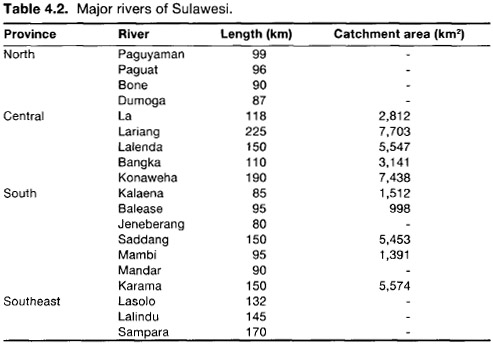
The size and shape of Sulawesi preclude the development of long rivers, such as those found on Sumatra or Kalimantan, and the longest is only just over 200 km in length (table 4.2). For comparison, the Kapuas River of West Kalimantan is over 500 km in length. The area of rivers on Sulawesi is estimated to be 299,520 ha or about 1.6% of the total land area (Sarnita 1973, 1974).

* Ranu is in fact two adjacent lakes of 480 ha and 270 ha.
** Maximum area and depth for Tempe during the dry season are 1,000 ha and 1.0 m respectively.
After Sarasin and Sarasin 1905; Fernando 1984; Anon. 1979a, b; L. Clayton pers. comm.

Figure 4.2. The lakes of the Tempe region with the areas under water during small and large floods.
After Anon. 1979a, 1982a

Figure 4.3. Depth contours of Lake Matano and Lake Moat of a type that can be used to calculate approximate lake volume.
After Fernando 1984; EoS team survey
PHYSICAL FEATURES
The formation of a lake is generally the result of geological processes. Once formed, the basin is doomed to die, following an assured sequence of stages from youth to senescence, at which time the lake has become full of sediment (Cole 1983). Examples of lakes in their final stages of 'life' are Lura (Enrekang), Mokobang (north of Mt. Ambang), Tempe and Limbo-to. The physical characteristics of a lake reflect the formation process as well as its stage; its chemistry is a reflection of the climate and physical condition of the surroundings. The ecology of Sulawesi's lakes are thus best understood through an initial description of the physical and chemical components.
The lakes can be divided into three major types; tectonic, volcanic and flood lakes. The majority are tectonic, that is, they were formed as a consequence of the movements of the earth's continental plates. Lakes Matano, Mahalona and Towuti are low sections of the Matano fault zone. Mahalona, Matano and Poso are flooded rift valleys (graben), while Towuti is a combination of a rift valley and more complex faulting. From deposits collected around Matano, its formation can be dated back to about 1.6 million years ago (B. Wahyu pers. comm.). Further, Miocene-age limestone on its southern boundary suggests that the area was under ocean water during the late Tertiary and early Quaternary.
From an analysis of the mollusc fauna on an island in Lake Lindu, it was concluded that the lake was formed during the Pliocene, between 5.0 and 1.6 million years ago, when part of the mountain range sank (Sarasin and Sarasin 1905; Bloembergen 1940). These dates do not seem to have had recent confirmation.
Lakes Tondano and Moat in North Sulawesi were formed as a result of volcanic activity. Moat is a high altitude depression surrounded by hills and mountains, and fumaroles near the northwest shore are evidence of continuing volcanic activity. Limboto and Tempe are flood lakes, or fairly flat depressions over which a river flowed in the past. Tempe appears to be a remnant of an ancient strait that formerly separated the southern arm of the Toraja highlands from southern Sulawesi (p. 20).
Scattered along the eastern part of the eastern peninsula of Central and Southeast Sulawesi are small lakes which can be seen clearly from the air. It is likely that these represent sinkholes, a characteristic of limestone topography (p. 470). One such lake has been described from the central peninsula in the south of Muna Island west of Lasongko Bay (Verstappen 1957) and the hills of Maros also reportedly contain such features (Baharuddin pers. comm.). Such lakes are usually shallow and circular, formed by slightly acidic rainwater dissolving the limestone, weakening and depressing the surface structure, such that the surface depression enlarges, or collapses entirely into the channel below. A lake is thus formed and may be fed by channel water or, alternatively, debris may choke off this underground supply and then surface water becomes the sole source of water.
Rivers usually arise in the headwater areas of mountains. They increase in volume and width as they flow downhill, joining other rivers to form a main river, that drains a watershed which may be thousands of hectares in area. Many temporary small rivers are created during rainstorms, particularly in headwater regions. Geology and topography determine drainage patterns and there are a number of types found on Sulawesi (fig. 4.4). Most are typical meandering channels, but the Palu River, several in Morowali National Park and the Jeneberang River, for example, are braided (Bloembergen 1940; Metzner 1981). This describes the small, shallow, interlaced rivers of lowland areas, formed after sediment is deposited during a major discharge. New channels form in the sediment when the water rises, joining, dividing, and joining again. Rivers may also originate at other water sources such as lakes (e.g., Tondano River at Lake Tondano, Guaan River at Lake Moat), limestone caves (e.g., Balangajir River, Maros) and swamps (e.g., Aopa River from Aopa Swamp).

Figure 4.4. Examples of three types of drainage patterns, (a) - dendritic radial, (b) - dendritic, (c) - trellis dendritic.
A catchment is drained by a hierarchical network of channels each of which can be assigned an order depending on its position and relationship to the other channels (fig. 4.5). Thus, the Jeneberang River (fig. 4.4c) is a sixth-order river at its estuary (Pudjiharta and Mile 1981). At the headwater region the stream bifurcation ratio is 3.55; that is, there are three-and-a-half times as many streams of one order as there are of the next higher order. It must be cautioned, however, that assigning orders to rivers depends very much on the map scale used; orders can increase by up to a factor of four on a larger scale map (Dunne and Leopold 1978). Nevertheless, there are evident biotic patterns in rivers correlated with stream orders, and the drainage pattern is a signature of the topography. The trellis pattern in the lower and middle reaches of the Jeneberang River, for example, indicates topographic control effected by parallel ridges and valleys.
Water Inputs and Outputs
The ultimate source of all freshwater is rain which is just one stage in the water cycle (fig. 4.6). Water flows along three pathways: overland, under the soil surface but above the water table, or via the groundwater. Whichever path is travelled, the water is subject to a variety of physical and chemical forces, including gravity, and eventually collects in a depression, river, lake or ocean.
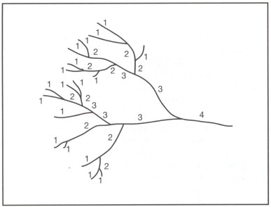
Figure 4.5. Hypothetical river basin showing the system of assigning river 'orders'. Thus: 1+1 = 2, 2+2 = 3, but 2+1 = 2, 3+2 = 3, etc.
After Strahler 1957

Figure 4.6. Water cycle.
After Townsend 1980
Most of Sulawesi's lakes are supplied by small inlet rivers: Towuti has 26, Tondano 25, Matano 10, Moat 7, and Limboto 6 (Achmad and Cholik 1977; Wardoyo 1978; Wardoyo and Thana 1978; Thana and Wardoyo 1980). The Lake Tempe region is fed by fairly large rivers from the south (Walanae), north (Bila) and west (Batu-Batu and others) (Anon. 1979a). At times of high river flows, water may back up in the Lawe Konaweha River which drains Aopa Swamp, causing the water level in the swamp to rise. Thus the swamp serves as a 'balancing' lake for the river system below it (Anon. 1981a).
The amount of rain reaching the ground below any vegetation cover depends on rainfall intensity and duration, and configuration and density of leaves. Some of the rain water that reaches the ground evaporates from the stomata or leaf openings of plants (transpiration), as well as from the soil, puddles, rivers and lakes (evaporation). Both transpiration and evaporation are difficult to measure but studies indicate that 21%-83% of the rainfall is lost through transpiration in a plantation forest, about 30% is lost through transpiration and evaporation in lower montane forest, and nearly 40% by both processes in the Ujung Pandang area (Wiersum 1979; Jager et al. 1984). Thus, over the period of a year only about 60%-80% of the rainfall actually enters rivers and lakes in the streamflow (Wiersum 1979; Whit-more 1984).
The response of a river to rain depends on the size, topography, geology and soil conditions of the catchment area above the river. Small rivers typically display a quick rise and fall of water levels after rain (e.g., fig. 4.35). Larger rivers are slower to respond to rainfall and the magnitude of the eventual response is less. After rain has fallen, groundwater may not appear as riverflow for hours, days, weeks or even longer. Delayed groundwater flow can therefore sustain low water flows in rivers or lakes through long, dry periods (p. 317).
Water Chemistry
The chemistry of a river or lake reflects the complex interactions of rainwater with soil, rock, plants and climate. Rain is not pure water—it contains low but measurable concentrations of dissolved gases particularly oxygen, nitrogen and carbon dioxide; positively-charged ions (cations) of hydrogen, sodium, potassium, calcium, magnesium and trace elements; and negatively-charged ions (anions), such as sulphates, nitrates, chlorides and phosphates. As the water percolates through or runs off a catchment area, it changes chemically due to the leaching of substances from soil and rocks. These nutrients infiltrate into the soil and are temporarily stored in soil water or are attached to the surface of soil colloids. This attachment or adsorption depends on the cation exchange capacity (CEC)3 of the soil, which in turn is dependent on pH and amount of clay, humus or organic matter. The CEC may be as low as 5 meq/100g for sandy soil and over 50 meq/100g for a clay.4 Water added to soil can cause some of the adsorbed cations to diffuse away from the exchange surface into solution. The ease of replacement from the complex is approximately H<ca<mg<k<="" span=""></ca<mg<k
Freshwater has remarkable buffering capacity, that is, it maintains its chemical characteristics within certain close limits despite the input of liquids with a different composition such as rain-water or factory effluent. The system can, of course be overloaded. However, a study of the effects of effluent from a coconut oil factory on the Tondano River found very little to be concerned about, since the majority of organic and inorganic pollutants were degraded through natural processes. The only aspect that did cause concern was the high concentration of suspended matter from soil erosion (Palenewan 1984).
During prolonged rainy periods, subsurface and overland flow are active in contributing rain and soil water nutrients to rivers. Water often turns a brown colour and suspended sediment concentrations are high, perhaps over 1,000 mg/1 (p. 320). At low flow periods, during the dry season, groundwater is the major contributor to river flow and the chemical composition of water better reflects the geology of the catchment area. Groundwater contains dissolved solids, or inorganic chemicals which eventually flow into receiving waters. These are measured by evaporating a known volume of water and weighing the dried solid residue. Freshwater has a total dissolved solid concentration of less than 1,000 mg/1,5 brackish water between 1,000 mg/1 and 10,000 mg/1, and salt water over 10,000 mg/1 (Freeze and Cherry 1979).
Temperature is important in determining water quality. As temperature rises, the rate of chemical reactions increases following the laws of chemical kinetics. Oxygen solubility decreases with increasing temperature and the rate at which oxygen is consumed through chemical and biological oxidation of organic compounds, the chemical and biological oxygen demand (or COD and BOD respectively) rises. Thus, a river suddenly exposed to greater sunlight, due to the felling of riverbank trees for example, will experience a dramatic change in water quality associated with the increased water temperature (p. 321). In addition to a lower dissolved oxygen concentration, the warmer water is conducive to the growth of aquatic bacteria that may be pathogenic to certain fish, and will probably alter the metabolic activity of most aquatic organisms. For a given quantity of organic matter, shallow, slow-moving rivers will have lower levels of dissolved oxygen and higher BOD levels than deeper, fast-moving rivers. Rivers at high altitudes generally have higher oxygen levels than those in the lowlands (Chye and Furtado 1982), because turbulent water facilitates the mixing of layers and keeps water temperature low and constant across and through a river; oxygen may also be replenished from bubbles formed in rapids, waterfalls or waves.
PLANTS
Macrophytes
The larger aquatic plants are called macrophytes. These produce complex micro-habitats which provide shelter for animals, act as a substrate for micro-organisms and serve as a homeostatic factor in the decomposition processes of organic matter by consuming carbon dioxide and producing oxygen. Fish use the aquatic plants for shelter and food, and also graze on the small plants and animals which reside on or near the plants. Birds take refuge in emergent plants during storms, make their nests there and eat small floating plants and seeds of these and other plants. Humans use macrophytes for feed (such as Ipomoea aquatica [Conv.] [fig. 4.7]), traditional ceremonies, green manure, paper, cattle feed, or simply for aesthetic purposes. Aquatic plants are divisible into five groups: those that grow on wet banks and are frequently flooded, those that are rooted beneath the water but project above the water surface (emergents), those that are rooted beneath the water but whose leaves float on the water surface, those that are rooted and grow wholly beneath the water, and those that float.
The submerged and floating macrophytes of Sulawesi6 (tables 4.3 and 4.4) include both very common species such as Ceratophyllum demersum (Cera.) (fig. 4.8), and very rare species such as Aponogeton lakhonensis (Apon.) (fig. 4.9) which is so far known from just two collections near Maros. The curly-leaved Ottelia mesenterium (Hydr.) (fig. 4.10) is endemic to Sulawesi and is known only from Lakes Matano and Towuti. A number of macrophytes are rare but are found over very wide areas which suggests narrow niche requirements rather than chance dispersal by aquatic birds. For example, the species of Najas in Sulawesi have ranges that include, North Africa, Kashmir and Australia, but in Indonesia, only one species is ever found in a single lake; they appear unable to live sympatrically. The one exception, however, is Lake Tondano which is reported to have three species (de Wilde 1962) but confirmation is needed. Freshwater at low altitudes generally has more species of macrophytes than freshwater at high altitudes (Bumby 1982) though this has yet to be studied in Sulawesi.

Figure 4.7. Ipomoea aquatica.
After van Oostroom 1953

Figure 4.8. Ceratophyllum demersum. Scale bar indicates 1 cm.
After van Steenis 1949

(a) - Not yet recorded from Sulawesi but likely to be found.
(i) - Introduced.
After van Steenis 1949a, b; Backer 1951; van Ooststroom 1953; den Hartog 1957a, b; de Wilde 1962; van Bruggen 1971; van der Plas 1971; and Taylor 1977

After Sarnita 1974; Anon. 1977a, 1979a, b, 1983a; Wardoyo and Thana 1978; Thana and Wardoyo 1980

Figure 4.9. Aponogeton lakhonensis. Scale bar indicates 1 cm.
After van Bruggen 1971

Figure 4.10. Macrophytes of the Hydrocharitaceae. a - Vallisneria gigantea, b -Blyxa auberti, c - Ottelia mesenterium, d - O. alismoides, e - Hydrocharis dubia. Scale bars indicate 1 cm.
After den Hartog 1957b

Figure 4.11. Floating ferns Azolla pinnata and Salvinia molesta. Scale bars indicate 1 mm.
The Isoetes (Isoe.) reported from Lake Matano or Mahalona is the only record of this aquatic fern from Sulawesi (Sarnita 1974). The species was probably I. philippinensis, which has numerous grass-like leaves up to 50 cm long, 7 mm broad at the base and about 3 mm across the middle (Alston 1959). Isoetes is of considerable interest in plant evolution because it has the most primitive indication of seed habit in any plant (Corner 1964). Two other aquatic ferns, Azolla pinnata (Azol.) and Salvinia molesta (Salv.) are common. Both species float and are particularly common in rice fields (fig. 4.11; p. 580).
A peculiar submerged macrophyte is the tiny Cladopus nymani (Pods.) (fig. 4.12) which is confined to swift but relatively unshaded rocky rivers with clear water. In Sulawesi it is known only from the southwest peninsula. During the rainy season it is sterile, but when the water level falls it flowers (van Steenis 1949b). The small Lemna and minute Wolffia (Lemn.) (fig. 4.13) are very common in still waters of the tropics but the latter has not yet been reported from Sulawesi.
One of the most interesting macrophytes is Utricularia which has no recognizable leaves or roots, but a mass of floating rhizoids that support erect flower stalks raised above the water (fig. 4.14). Absorption of water and nutrients is conducted through the finely divided leaves. The modified leaves bear numerous bladders, the function of which is to catch small animals and so supplement the conventional means of obtaining nutrients. Each bladder has a single opening in which sits a tightly-fitting hinged door. In their relaxed state the bladders are rounded but are usually seen with slightly concave sides because the cells of the bladder have actively passed water to the outside. If the door or the hairs around it are disturbed, it swings inwards because of the reduced pressure, sucking in with it whatever small animal caused the disturbance. The animal dies and decomposes within the now-rounded bladder and the process of passing water to the outside and setting the trap begins again.

Figure 4.12. Cladopus nymani; single plant and a group on a stone.
After van Steenis 1949b

Figure 4.13. Lemna and Wolffia globosa, common, small, floating macrophytes. Wolffia contains the world's smallest plants; W. globosa measures just 0.4 mm high and 0.5 x 0.2 mm in length and width.
After Holttum 1954; van der Plas 1971

Figure 4.14. Bladderwort Utricularia.
After Holttum 1954
The water hyacinth Eichhornia crassipes (Pont.) is a Brazilian plant that was brought to Indonesia at the end of the last century and is now considered a serious weed. It was introduced to Sulawesi relatively recently. In a review of its distribution published thirty-five years ago, Sulawesi was not mentioned (Backer 1951). Another floating, introduced macrophyte is the water cabbage Pistia stratiotes (Arac.) (fig. 4.15) which has caused serious problems in African lakes.
Observations of macrophyte distribution away from a shore will quickly show how different species grow in different zones. In lakes with steep sides, such as Lakes Matano (Anon. 1980), Teu and Poso (figs. 4.16 and 4.17), the zones are extremely narrow and the macrophyte community relatively small compared with the area of the lake, but in lakes with very gently sloping sides, such as Lake Tempe, the zones can be very broad and the macrophyte community can cover the entire lake bed.

Figure 4.15. Pistia stratiotes.
After Holttum 1954

Figure 4.16. Macrophyte zonation in Lake Ranu. A, B, C, E - sedges, D, - Polygonum, F, G - Chara mosses, H - Najas.
After L. Clayton pers. comm.

Figure 4.17. Zonation of macrophytes in Lake Poso. A - emergent dicots, B - emergent grasses, C - submerged plants, D - emergent sedges, E -mosses.
After L. Clayton pers. comm.
The shallow region close to shore, up to about 1 m in depth, forms the primary habitat of emergent macrophytes. These plants utilize the resources of both aquatic and terrestrial environments: there is a very rich nutrient supply in the sediments in which they are rooted, and they have an advantage over submerged plants in that they have direct access to light, oxygen and carbon dioxide. This productivity of emergent macrophytes in eutrophic lakes is consequently very high. Between 1 m and 3 m depth, plants whose rhizomes are rooted to the ground but have extended their leaves to the surface can be found: an example is the water lily Nymphaea (Nymp.). Deeper still, up to about 10 m depth in clear water, are found the submerged macrophytes. Floating plants can be found on water of all depths and their distribution is determined primarily by currents and wind.
At Lake Tempe, an EoS team collected and dried the above-ground parts of plants at intervals along a transect from land to about 6 m from the shore. Although the perimeter of the lake fluctuates and is disturbed by cattle and humans, it is evident that the highest biomass of plants occurs at the water's edge (table 4.5), where a mixture of terrestrial and aquatic plants grow together. Biomass decreases in both directions from the water's edge, but dense mats of the cultivated Ipomoea aquatica were found in other areas of the lake that had a biomass of up to 1,360 g/m2, in water 0.5 m deep.
The zonation is ultimately the result of the physiological problems faced by the aquatic plants caused by the limited diffusion of carbon dioxide and oxygen, relatively low light levels, and high water pressure. Oxygen tolerance is achieved by having up to 60% of the tissue volume occupied by air spaces (Moss 1980). For example, one-third of the tissue volume of Ceratophyllum demersum (Cera.) consists of air spaces. Anaerobic metabolism in sediments under water produces ethanol, of which rooted macrophytes are tolerant through a compensating biochemical mechanism. Photosynthesis is also limited by shortage of carbon dioxide, particularly at high pH, but some plants, such as C. demersum, are reportedly able to utilize bicarbonate directly, and others are adapted to low rates of free carbon dioxide (Moss 1980).

Data from an EoS team
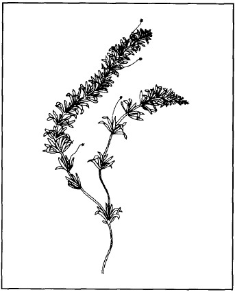
Figure 4.18. Hydrilla verticillata.
After den Hartog 1957b
Light is absorbed quickly by water, so submerged plants receive only a small proportion of the light reaching the water surface. Water lilies develop long petioles so that their leaves can float on the surface and therefore receive light directly. Submerged leaves assume a morphology similar to terrestrial shade plants; their leaves are thin and contain many chloroplasts thereby maximizing the use of available light energy. Hydrilla verticillata (Hydr.), a widespread submerged macrophyte (fig. 4.18), for example, is able to maintain a high photosynthetic rate at low light intensities (Finlayson et al. 1984), and can be found 6-7 m below the water surface (den Hartog 1957b).
Water pressure limits vascular plants to about 10m depth7 in lakes, but mosses and algae can live much deeper; Chara sp.,8 a green alga with a stout stem and whorls of slender branches which are themselves branched, has been found at 164 m in a lake in California (Moss 1980).
Aopa Swamp (p. 446) is one of the better-studied aquatic ecosystems on Sulawesi and the most recent investigation by a team from Bogor Agricultural University (IPB) divided it into four ecological zones (fig. 4.19):

Figure 4.19. Ecological zones of Aopa Swamp.
After Anon. 1983a
Zone I or Makaleleo is the whole of the western swamp and the western portion of the eastern swamp. The vegetation cover is more or less continuous. The water is coloured as black as strong coffee and has a pH of 6.5 (Anon. 1983a) to 5.5 (Thana et al. 1981).
Zone II or Aopa extends part-way into the eastern swamp from the dike. In the rainy season some of the water comes from the Konaweha River and has the colour of strong tea and a pH of 6.6. Water plants here and in the following zones are less abundant so that open water is common.
Zone III or Muara Aopa extends further east again up to the western bank of the Konaweha River. This zone receives water from the Konaweha at all seasons. The water colour is like weak tea and slightly alkaline (pH 7.1).
Zone IV or Tangenutu covers the rest of the swamp and is influenced by water from both the Konaweha and Lahumbuti Rivers. The water has no obvious brown colour and a pH of 6.7. The last two zones are mesotrophic tending to eutrophic (Anon. 1983a).
The dominant aquatic plants differ between zones (table 4.6), but grasses and sedges accounted for 90% of those found. Among the submerged plants Ceratophyllum and the small Utricularia are the most common (Vaas 1956).
A report from 30 years ago observed that lotus plants Nelumbium nelumbo (Nelu.) covered 60% of the water surface (Vaas 1956). These areas may not have been enumerated by the IPB team or may have since become dominated by other species. The lotus is often confused with water lilies Nymphaea but the two are quite distinct (Appendix E).
The productivity of most submerged plant communities is about five times lower than that of emergent, floating or terrestrial macrophyte communities (18 t/ha/yr against 75-100 t/ha/yr) (Sutton 1985) due to the reflection of light from the water surface and suspended particles in the water, lower rates of gas transmission, epiphytic algae and protozoans that shade the leaf surfaces, and the general absence of extensive root systems. As a result, emergent rooted plants will quickly overgrow submerged ones where conditions are suitable. Productivity varies considerably depending on environmental conditions: thus in sunny pools algae has been found growing six to seven times faster than in shaded pools and this influences the density of algae-feeding fish (Power 1983).

* This plant (shown in fig. 4.20) is sometimes referred to by its old name Jussiaea repens.
After Anon. 1983a

Figure 4.20. Ludwigia adscendens, a small emergent macrophyte found in damp locations throughout Sulawesi.
After Raven 1977
The quantity of dead aquatic plants may be so high that organic matter accumulates in the water, thus reducing water clarity and concentrations of dissolved oxygen, and increasing BOD. The decomposition half-life (the time taken for half of a leaf to disappear through decomposition) of three common Sulawesi macrophytes, Salvinia molesta, Hydrilla verticillata and Eichhornia crassipes at 26°-32°C is relatively rapid, 23.5, 20 and 11.5 days respectively, compared with leaves from terrestrial ecosystems (Sastrautomo 1985).
Aquatic macrophytes release oxygen into the water as a product of photosynthesis, and this is used for respiration by animals and decomposers on decaying or dead material. When organisms die, organic matter is released into the water, taken up by plants and animals, and thus increases the rate of nutrient cycling in the ecosystem (Sastrautomo 1985).
Phytoplankton
Green algae are the major primary producers in lakes and rivers and microscopic phytoplankton is the principal group of algae in lakes. These organisms float or drift near the water's surface, often together with microscopic animals (p. 286), and are the major photosynthetic producers. They have many unusual shapes, with spines, horns and hairs, which were originally thought to increase surface area and thus help in buoyancy, but are now believed to have evolved in response to absorption and defence against herbivory as well (Cole 1983). Apart from these different types of green algae, phytoplankton include flagellates, diatoms and blue-green algae (Cyanobacteria). Although some bacteria are photosynthetic, they are considered to be neither plant nor animal, since they combine characteristics of both.
The phytoplankton are conveniently divided into two groups on the basis of size: net plankton, which are retained by the silk of a net whose openings are normally 50 µm9 or larger; and the nanoplankton which pass through the net as it is lowered and raised through the lake (Cole 1983). The latter group may be more numerous, up to a million in one litre of lake water, while net plankton may number thousands per litre (Moss 1980).
The phytoplankton lead a precarious existence. They are readily preyed upon by fish and zooplankton, their habitats may be destroyed by desiccation or incoming floodwaters, or they may sink to the bottom of the lake where they perish due to lack of light. These conditions have favoured the selection of rapid reproduction by simple cell division which can occur every few hours or days (Moss 1980).
Forty-eight genera of phytoplankton, in six families, have been found in Lake Tondano where there is a linear relationship between numbers of individual phytoplankton and zooplankton (Ratag 1981). At Lake Moat there were 47 genera from seven families (Buchari 1984). Although the number of genera were almost equal for the two lakes, the actual number of individuals per litre of water differed considerably: 2,413 in Tondano and only 140 in Moat. The highest count was for Aopa Swamp at over 19,000 individuals per litre (Anon. 1983a) (table 4.7). From this count, evaluations of zooplankton, algae and fish abundance, and from the distribution of aquatic plants, Moat is considered to be oligotrophic, or nutrient-poor, and Tondano and Aopa Swamp to be eutrophic, or nutrient-rich (p. 340).
In addition to the lakes of above, partial lists of phytoplankton are available for the three lakes of the Malili system (Achmad 1974), and Limboto (Wardoyo and Thana 1978).
In rivers, algae attach themselves to large rocks or boulders, and only when river flow is slow can substantial phytoplankton development occur. Factors limiting their growth and productive potential are high sediment loads, insufficient rocks, and the absence of suitable microhabitats (Chye and Furtado 1982). A survey of phytoplankton at three points along the Jereberang River by an EoS team found 16 and 14 genera of phytoplankton in the relatively slow-flowing headwaters (1,440 m altitude) and in the lower reaches (about 5 m) respectively, but only 6 genera in a swift middle reach (850 m).
Fungi, Bacteria and Blue-green Algae
The major decomposers in freshwater are bacteria and aquatic fungi. The dominant group of fungi is the Hyphomycetes which colonizes corpses, faeces, and dead plant material. Fungal spores often have four projections (fig. 4.21), which favour their attachment to solid matter, even in fairly turbulent waters (Moss 1980). Knowledge of the biology and ecology of the decomposers is confounded, however, by their minute size and the difficulty of meaningful sampling.
Bacteria are generally dominant among macrophytes where, along with algae, they live epiphytically. It has been discovered that the leaves of macrophytes such as Najas flexilis actually secrete organic material, including glucose, sucrose, fructose, xylose and glycine, and these are readily taken up by bacteria (Moss 1980). The strategy, if any, of this relationship remains unclear.

After Sarnita 1973, 1974; Anon. 1977a, 1979b, 1980, 1983a; Pirzan and Wardoyo 1979; Ratag 1981; Umar 1984

Figure 4.21. Fungal spores.
The blue-green algae, or Cyanobacteria, are present in an enormous range of habitats including hot springs hotter than 55°C (Kullberg 1982). They have evolved the use of chlorophyll 'a', the most important photosynthetic pigment in higher plants, and are thus, along with green algae, primary producers of oxygen in freshwater habitats. They are also capable of fixing nitrogen (Cole 1983). Overgrowth or blooms of blue-green algae, however, produce toxins dangerous to fish and other animals.
FAUNA
The fauna of lakes and rivers can be roughly categorized by the micro-habitat they occupy. Thus:
• the neuston comprises those animals able to live on the surface of the water supported by surface tension, such as pond skaters or water striders (fig. 4.22);
• the nekton comprises swimming animals such as fish;10
• the zooplankton comprises animals that drift in the water or swim weakly, such as small crustaceans and protozoan rotifers;
• the benthos are those animals closely associated with the river or lake bed, such as many insect larvae, molluscs, prawns and crabs.

Figure 4.22. A water strider or pond skater (Gerridae) a common member of the neuston.
Zooplankton
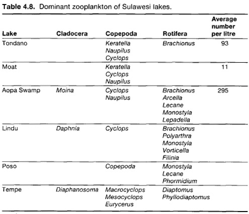
The zooplankton are the most numerous animals of lakes and some rivers and are also the smallest, with sizes ranging from 0.2-5.0 mm (Moss 1980). The zooplankton of Southeast Asia has relatively few species of the single-eyed Copepods, or of the Cladocera (waterfleas) (Fernando 1980), and Sulawesi is no exception (table 4.8). It is believed that at Lake Matano the high quantity of chromium (0.04 ppm) and the presence of the other heavy metals such as cobalt and manganese (Anon. 1980) may have produced an environment unsuitable for at least Cladocera (Fernando 1984). It is important to understand that in such conditions it may not be the high concentration of any one metal but rather the combined or synergistic effects of the different metals that influence the distribution of a particular species.
The zooplankton are primarily represented by four groups; the protozoa, rotifers, waterfleas and copepod crustaceans. These animals prey on phytoplankton or smaller zooplankton in a variety of ways. Plankton such as the waterfleas grasp their prey, while copepods waft the smaller organisms towards their mouths using their thoracic limbs, rotifers filter water through their mouth, and some protozoans spread around an item of food and engulf it (Moss 1980). Certain phytoplankton can travel unharmed through the digestive tracts of zooplankton and in fact absorb nutrients during their passage (Cole 1983).
Altitudinal variation in zooplankton abundance was examined by an EoS team along the Jeneberang River system. At 1,440 m only a planktonic larva of an arguloid fish louse was found, no zooplankton at all were found in the fast-flowing middle section at 825 m (where very few phytoplankton genera were found-p. 284), but a wide range of zooplankton were found in the waters at a slow lowland station where populations were able to develop and phytoplankton was relatively abundant.
Macro-invertebrates
Macro-invertebrates, invertebrates visible to the naked eye, can be categorized as:
• shredders: those feeding on large units of plant material;
• collectors: those feeding on loose organic particles either on the riverbed or free in the water;
• grazers: those feeding on attached algae, rotifers and bacteria; and
• carnivores: those that (usually) kill and eat other animals.
Most of the non-benthic macro-invertebrates are found associated with macrophytes. These plants act as refuges from predators, as substrates for algae, diatoms and rotifers, but are not themselves eaten by invertebrates. At first sight this is peculiar since the leaf cuticles are thin and few possess spines or hairs that might dissuade invertebrate herbivores from eating them. It has been suggested that the plants simply are not very nutritious but in fact they contain as much protein as high-quality forage crops. In fact, the most likely reason why macrophytes are not eaten is rather because many of them appear to have significant quantities of a wide range of defensive chemicals (alkaloids) in their leaves (p. 371) (Ostrofsky and Zettler 1986). The types and diversity of macrophytes in an area play a major role in determining the abundance and diversity of macro-invertebrates present (Scheffer et al. 1984).
After Sarnita 1973, 1974; Anon. 1977a,1979b, 1983a; Pirzan and Wardoyo 1979; Ratag 1981
Freshwater molluscs are among the better-known groups of macro-invertebrates. From the distribution of species, it appears that the species on Sulawesi may be divided into two categories: those that have a few, widely distributed species, and those that have many species, most of which are endemic to the island or a single lake. A total of 45 molluscs are known from Sulawesi's lakes and of these 17 are recorded from Lake Poso (fig. 4.23; table 4.9).11 Not all the lakes have received equal attention, however, and the total for Towuti, the largest lake, seems surprisingly small, but otherwise the ancient lakes of Poso, Matano and Towuti have the highest proportion of endemic species (67%, 76%, and 87% respectively). Lake Poso has the most distinctive mollusc fauna, including many species with primitive characters, and has two genera confined to its waters one of which, Tylomelania, comprises three species. As described elsewhere (pp. 52 and 297) some of these species may now be extinct.
The affinities of the different mollusc faunas are of interest. The greatest similarity (as measured by the percentage of species shared between two lakes) is, not surprisingly, between Tempe and neighbouring Sidenreng which share four (50%) of their eight species. Water from Lake Matano flows into Lake Towuti but only 10% of their total mollusc fauna appears to be shared between them. The mollusc species in these two lakes are not shared with any other lake. Conversely, Lake Poso with its distinctive fauna shares species with all the other lakes. Interestingly, the shallow and intensely-used Lake Limboto shares 10 (30%) of its mollusc species with the Tempe Lakes, although the lakes are separated by over 600 km. The similarity is probably due to the shallowness and surrounding land use common to both lakes and to the fact that many of the the snails are widespread and have probably been introduced along with fish.
Swampy lakes such as Lura, Bolano and to some extent Aopa Swamp have very simple mollusc faunas comprising relatively common species. For example, Aopa has Ampullaria, Planorbis and Vivipara, Lura has a single widespread snail of agricultural areas Lymnaea aurimlaria, and Bolano has two species of Pila, snails that have accessory breathing organs.
A bivalve mollusc of interest collected during Project Wallace in Bogani Nani Wartabone National Park was Anodonta woodiana found in the Toraut River. This species is a native of China and Taiwan, and was introduced to Java (Djajasasmita 1982) and has probably spread to Sulawesi along with the introduced fish tilapia Oreochromis on which it encysts during the glochidial larva stage (D. Dudgeon pers. comm.). A. woodiana is the largest freshwater mussel recorded from Indonesia: it can reach 27 cm long, 13 cm high and 61 cm wide and is of an olive to dark-green colour (Djajasasmita 1982).

Figure 4.23. Two of the endemic freshwater molluscs of Sulawesi. Miratesta is an endemic genus confined to Lake Poso.
Details of abundance and distribution of four snail species or species groups have been studied in Lake Tondano. Samples were taken once each month for three months and few clear patterns were found except that, in general, the snails were most common where macrophytes were most dense. In addition, some species were found more commonly over sand and others over mud (Buchari 1981). It is commonly stated that snails feed by grazing algae from stones and plants but this oversimplifies a situation in which different species prefer different foods and many ingest predominant inorganic material and detritus (Dudgeon and Yipp 1983b).
There is little information available concerning the ecology of tropical freshwater snails. The generally large, medically-important (p. 297), air-breathing pulmonate snails generally breed frequently and abundantly and this appears to lead to a reduced adult life span. These snails may be regarded as r-selected (p. 345) and this probably reflects the often temporary nature of their habitats (pools, rice fields, lake fringes). The more common prosobranch snails (with no lungs) on the other hand tend to have frequent broods of relatively few young (sometimes born alive rather than hatching from a egg laid in water), and have longer adult life spans. These snails seem to be K-selected. The bearing of live young (viviparity) is clearly advantageous for a river-dwelling snail since planktonic larvae would be carried downstream and out to sea. It is not surprising, then, that the viviparous snail family Thiaridae dominates the headwaters and middle reaches of rivers in the Old World tropics (Dudgeon 1982b).
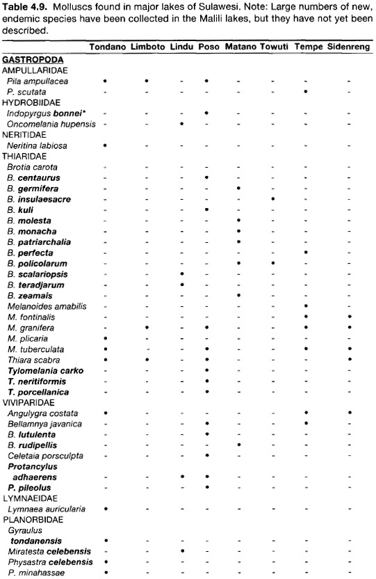
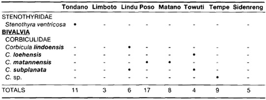
* Species and genera endemic to Sulawesi are shown in bold type.
After Djajasasmita 1972, 1975; Carney et al. 1980; Buchari 1981; and EoS teams
One of the most common and widespread thiarid snails is Melanoides tuberculata which is found in lakes, irrigation ditches and similar habitats from Africa to the Pacific Islands. Not only does this snail give birth to fully formed young, but it reproduces without the eggs being fertilized (parthenogenetically). Populations have 0%-3% males, but they do not appear to function sexually. All individuals are therefore genetically identical and this lack of evolutionary potential might be thought to doom the snail to extinction. It would seem, however, that M. tuberculata has all the adaptive potential required since it is an extremely effective colonizer. One particular adaptation favouring colonization is the presence in the snail's brood pouch of young of all ages: eggs, larvae and small snails, the last of which can be released throughout the year or when environmental conditions are favourable (Dudgeon 1986a).
Freshwater molluscs have been eaten by man since prehistoric times (p. 74) and are commonly eaten by villagers in certain areas even today. Only in Lake Tempe, however, does there seem to be a commercial mollusc fishery. In 1976 the lake produced 51 tons of mussels Corbicula and 34 tons of Pila scutata (Anon. 1979b).
Another group of macro-invertebrates used as food is the river prawns. The Sulawesi species are very poorly known but during Project Wallace four species of Macrobrachium (latimanus, lepidactyloides, australe and lar) and two of Atyopsis (spinipes and moluccensis) were found in the Toraut River (D. Dudgeon pers. comm.).
Among the aquatic insects the Hemiptera are represented by several families three of which are relatively often encountered: the giant water bugs (Belostomatidae) (fig. 4.24), the water boatmen or backswimmers (Notonectidae), and the pond skaters or water striders (Gerridae). The giant water bugs are attracted to lights at night and look superficially like large (about 8 cm) cockroaches. They can deliver a painful bite if handled carelessly. Their front legs are used for grabbing prey, while the middle and hind legs are used for swimming. The water boatmen swim upside down and have long hind legs which are used as oars. The bodies and legs of pond skaters are covered by a dense pile of water repellent hair and this helps them to be supported by the surface tension. They prey on other insects or catch dead ones using their front legs while the middle and hind pair of legs scull across the water. Small pools along the Tumpah River in Bogani Nani Wartabone National Park were found to have up to five genera of pond skaters, and this raises interesting questions concerning their respective feeding strategies and spacing which will hopefully be answered in due course (Calabrese 1986; D. Polhemus pers. comm.).
Ubiquitous and interesting members of the benthos in relatively undisturbed rivers are caddisfly larvae, the adults being moth-like insects, often dull-brown in colour.12 Some groups construct a silken tube adorned with grains of sand or other material which they carry around with them. These larvae feed on plants. Another group, the Hydropsychoidea, which dominated the caddisfly fauna in the Toraut and Tumpah Rivers in Bogani Nani Wartabone National Park (A. Wells pers. comm.) spin nets of different mesh sizes which trap detritus and drifting invertebrates on which they feed. Larger mesh sizes tend to be found in the headwaters and smaller sizes in downstream region, appropriate to the differences in the sizes of suspended matter (Townsend 1980). This was studied during Project Wallace but the detailed results are not yet available (Dudgeon 1985b). Species may also be distributed differentially across a stream: the rigid nets of certain species predominate in the fast-flowing riffles, and flimsy and weaker nets of other species are more often found in the slower-flowing water of pools.

Figure 4.24. Giant water bug Belostoma indica.
Schistosomiasis and Echinostomiasis of the Lindu Valley
During preliminary studies of the disease echinostomiasis in Indonesia during the 1930s and 40s, a focus was found in the Lindu valley 50 km southeast of Palu. Schistosomiasis, also called 'bilharzia', is caused by a blood-fluke, or trematode flatworm Schistosoma, which is about 1 cm long and lives in the main veins of the middle and lower abdomen in certain mammals including humans. Early symptoms of the disease are itching of the skin caused by the entry of the aquatic larva, and skin eruption around the entry point. Four to six weeks later a high fever starts accompanied by coughing, abdominal pain and rashes. There are attacks of diarrhoea, and blood and mucus appear in the stools. As the disease progresses, the liver, heart, brain, spinal cord and pancreas can be affected and ulcers form on the skin. Victims may live for many years after contracting the disease, but become gradually weaker, and many eventually die of exhaustion or succumb to other diseases because of their weakened condition. Treatment requires expert supervision (Hadidjaja 1982).
The major fluke found in Sulawesi, Schistosoma japonicum, is known from elsewhere in the Oriental region and the early studies found that not just humans but also dogs and wild deer were infected. Like all other parasitic worms, the life cycle involves at least two organisms. Some trematodes such as Alaria require four hosts: snails, frogs, rats, and then a mammalian carnivore such as dogs or cats, and then snails again.
In the adult S. japonicum, the sides of the male's body fold over to form a groove in which the longer and more slender female is held. They both cling to the walls of the intestine where they suck blood using two suckers near their heads. The female lays her eggs in small blood vessels in such numbers that the vessels become congested. As a result, the eggs, which are armed with a sharp spike, rupture the walls, are discharged into the intestine and are subsequently passed out with the faeces. If these are deposited in water the eggs hatch into a ciliated or hairy larva called the 'miracidium' which is capable of swimming weakly. It can survive only about 24 hours on its own but, if it encounters a snail, it burrows into the soft body and feeds on the snail's tissues. The hairs are lost and the miracidium produces asexual buds which develop into cercaria. These are similar to the adults except that they possess a tail. The cercaria burrow out of the snail and float to the surface of the water where, if they come into contact with skin, they attach themselves by means of glands the secretions of which are also used to digest their way into a blood vessel. The larvae are carried in the bloodstream to the intestinal vessels where they feed and develop into adults (fig. 4.25).
In the 1970s there was a renewal of interest in Indonesian schistosomiasis when the intermediate host, the snail Oncomelania hupensis (fig. 4.26) was found in Lake Lindu (Carney et al. 1973), confirming that the organisms involved were the same as in the Philippines, Japan and China where schistosomiasis is widespread. The list of animals known to be infected by the adult worms grew to include civet cats, rats, shrews, wild pigs, water buffalo, cattle and horses, although the domestic species had relatively low rates of infection (Carney et al. 1978). Infection occurs all around the swampy edge of the lake but the distribution of the snails is focused. Both snails and flukes have also been found in the Napu valley to the east but none, at least in Sulawesi, have been found in other water courses or at elevations lower than 1,000-1,200 m (Cross et al. 1975, 1977; Carney et al. 1977a, b; Putrali et al. 1977; Stafford et al. 1980). Therefore, no other major lakes in Sulawesi should be affected. This apparent inability to disperse is fortunate since water from the Lindu River eventually flows through Palu.
The only reason schistosomiasis is not more widespread is because of the restriction of the host snail to the above areas, but the cause of this isolation is by no means clear. In the Philippines the same species of snail is found near sea level and is known from 900 m above sea level in one province of Mindanao. Rice culture as practised in remote areas and growths of water hyacinth create habitats favourable to 0. hupensis, but wet-rice culture was unknown in the Lindu area until the start of this century and water hyacinth was introduced into Sulawesi after the disease was confirmed (p. 275). O. hupensis is also found in long grass adjacent to rice fields, abandoned rice fields in swampy areas with a relatively dense cover of vegetation, and in grassy irrigation ditches. Its presence in agricultural and disturbed areas is, however, a secondary adaptation since both the fluke and snail occur in primary forests (Carney and Sudomo 1980). The natural habitats of the snail are moist areas either in the zone between forested hills and marshy lowlands, or where forest vegetation borders the lake shore. In contrast to disturbed areas, these habitats have a relatively constant and cooler temperature. It is most unlikely that the disease was introduced by humans in historical times, but then its natural dispersion from the Philippines would seem plausible only if it were known from intervening high altitude lakes such as Lake Moat and Lake Tondano, which it is not.

Figure 4.25. The life cycle of Schistosoma japonicum.
After Barnes 1968

Figure 4.26. Oncomelania hupensis the intermediate host of the fluke Schistosoma japonicum. Scale bar indicates 1 mm.
Despite knowledge of the disease and its ecology a transmigration site was established near Lake Lindu in a major O. hupensis area during the 1970s. Not surprisingly, within six months 60% of the transmigrants, about 500 individuals, were infected with the fluke (Carney and Sudomo 1980). The scale of the control problem was illustrated by counts of the snail population which found over 1,339 snails/m2 at one abandoned rice field focus with an area of 750 m2, giving a population of 1 million snails there alone. The land area of the Lindu valley is about 50 km2, and if a conservative density of 500 snails/m2 over just 10% of the area is accepted, then the number of O. hupensis is 2.5 billion! Of course, not all snails are infected; an infection rate of just 2.4% has been found, but that still represents 600 million snails carrying developing larvae. About 7,000 people are continuously exposed to schistosomiasis and about 2,500 of these are actually afflicted with the disease (Carney and Sudomo 1980).
A successful pilot control project was undertaken using mass treatment of human sufferers, agro-engineering, molluscicides, improved sanitation and health education (Putrali et al. 1980), but this was not maintained, and the incidence may increase. Local resettlement programs relocated people from other areas of Sulawesi in confirmed schistosomiasis areas resulting in infection. This led in turn to the departure of the migrants and, in some cases, the move to slash-and-burn agriculture in previously forested areas. Much of the credit for the relatively low incidence of schistosomiasis found around Lake Lindu today must go to Daniel Samel who works extremely hard at informing local people of the means of avoiding the disease. Recognition of his service and dedication was given in 1986 when he received a Kalpataru Environment Award from President Soeharto.
Another species of fluke S. incognitum is found around Lake Lindu and also further south in other river systems (Carney et al. 1977b). This is not (yet) a parasite of humans but it is common in tissues of domestic animals and commensal rodents. Its snail host Radix auricularia occurs in the same habitats as O. hupensis, and humans are frequently exposed to it. Only a small change in its genetic make-up may be necessary to allow it to exploit humans, with a consequent vast niche expansion. The fact that the two fluke species are sympatric in part of their range could also lead to hybridization; mating of the two species has been observed in rodents but the viability of the eggs was not determined (Stafford et al. 1980). If a viable hybrid were to arise and if it used the common Radix as its intermediate host, schistosomiasis could become a very common and widespread disease in Southeast Asia (Carney and Sudomo 1980).
Another potential danger is the accidental introduction of another schistosome snail host Biomphalaria straminea. This has been found in aquarium fish farms in Hong Kong, the fish from which are exported all over the world (Dudgeon and Yipp 1983a). The chances of one of these snails being infected by a dangerous schistosome are slight, but it is nonetheless important to take great care in all fish introductions, even those destined for home aquaria.
During the early surveys of schistosomiasis a related disease, echinostomiasis caused by echinostome flukes, was also found. Echinostomiasis is generally rare and of little clinical importance, but the residents of villages around Lake Lindu were exceptional in having very high rates (up to 96%) of infection. Studies indicated that various molluscs were the intermediate host of the echinostome larvae and that the bivalve mussels Corbicula lindoensis and C. subplanata were the primary source of human infection.
In the 1940s, mussel beds were common along the shore of Lake Lindu and mussels, often raw or lightly boiled, were a substantial item in the human diet. The high incidence of infection continued through to at least 1956. In the 1970s, however, no echinostome eggs were found in faeces from people living around Lake Lindu. During the intervening 15-20 years most of the mussel beds had disappeared except in one virtually inaccessible spot near the outlet of the lake in the north.
The disappearance of the mussels (and other molluscs) is almost certainly due to the introduction of fish (p. 52). The predatory snakehead Channa striata was present in Lake Lindu during the 1940s, but the tilapia Oreochromis mossambicaus was not introduced until 1951. The most likely cause of the mussel demise was the predation of young tilapia on the planktonic mussel larvae (Carney et al. 1980).
The echinostome is not extinct, however, and has been found in rats, birds and shrews, but if no new channel of infection to humans is introduced then human echinostomiasis will remain a disease that disappeared (Carney et al. 1980).
Fish
All of the indigenous fish of Sulawesi are of marine origin but are now adapted to freshwater life (p. 52). In Lake Tempe, brackish water fish such as Mugil sp., Leiognathus sp., Terapon sp., Glossogobius sp., and Anguilla sp. are common, even though the lake water is fresh (salinity < 3 ppt), and the connection to the sea is 70 km to the east (Suwignyo 1978). Also, eels in Lakes Poso and Moat start life in the depths of the ocean 50 km and 15 km away, respectively. The young swim upriver as 'elvers' to grow into adults in the lakes before returning to the ocean again to breed.
Details of the fish in Sulawesi rivers are hard to find but the species in the Mamasa River, southwest of Rantepao, comprised largely introduced or widespread indigenous species (Anon. 1982a). Recent collections from the rivers meandering through the forested karst areas of Maros revealed two new species of halfbeaks Dermogenys (Brembach 1982).
In the early 1970s it was observed that Lakes Lindu, Poso, Towuti, Matano and Mahalona were inhabited by fish that did not fully exploit the natural food available. It was therefore recommended that barbs Puntius spp., Labiobarbus13 spp., Osteochilus spp., Thynnichthys spp., Mystacoleucus marginatus, Nile tilapia Oreochromis nilotica and Leptobarbus hoeveni could be introduced. At no point in the reports was thought given to possible effects on the indigenous fauna, although further studies were recommended to ensure rational fisheries management. Even today most regional fisheries staff are unaware of the existence of the indigenous fish species and no efforts are made to increase their production.
The endemic fish known from Sulawesi lakes are quite remarkable and the Malili lakes most significant 'hotspot' of freshwater biodiversity in Asia (table 4.10). Some of the endemics of Lakes Poso and Lindu may have become extinct as a result of competition and disease from introduced species (p. 52) (Whitten et al. 1987). The snakehead Channa striata14 and the climbing perch Anabas testudineus (fig. 4.27) are often listed as being indigenous to Sulawesi but it is much more likely that they were brought by humans before scientific attention was paid to the fish fauna. Both species are airbreathers and easily transported.
Knowledge of the ecology of indigenous Sulawesi fish has increased substantially as a result of the work of Kottelat (see Introduction), and relatively little is known even of the introduced species important to fisheries. Communities of fish have been the subject of study in rivers in Sri Lanka and Panama. In the latter study, seven groups of fish based on their feeding habits were identified (algivores, piscivores, aquatic insectivores, etc.) and some fish changed their group with age. All feeding guilds except aquatic insectivores were concentrated (in terms of biomass/unit area) in the deep pools even though this was not necessarily where food was most abundant. With increasing river width the number of species increased, as did the density of algivores and other herbivores, presumably because of the greater amounts of light striking larger rivers (Angermeier and Karr 1983).

* The known locality of this species is "the area of Makassar" Most of the hemirhamphids, phallostethids and teraponids are not known from lakes but from rivers.
After Boulenger 1897a; Popta 1905; Weber and de Beaufort 1922; Aurich 1935a, b, 1938; Ahl 1936, Koumans 1953, Ladiges 1972; Brembach 1982; M. Kottelat pers. comm.
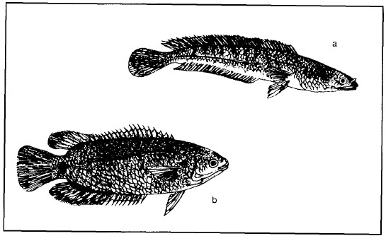
Figure 4.27. Snakehead Channa striata (a) and Anabas testudineus (b) are fish probably brought by humans to Sulawesi centuries ago.
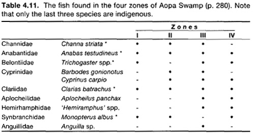
* Possess accessory respiratory organs: hind gut in Monopterus, near or around gills in the others. The ecological characteristics of most of these species are described in table 9.2.
After Anon. 1983a
The fish of Aopa Swamp are all widespread or introduced species (table 4.11). Those found in the blackwater swamp or Zone I have accessory breathing organs; this is not surprising considering the dissolved oxygen in its water is only 0.43 ppm compared with 2.41, 4.92 and 5.37 in Zones II, III and IV respectively. The readings were taken around midday when plants were actively photosynthesizing. Conditions at night would therefore be even less favourable. The mosquito fish Aplocheilus panchax15 exploits the high oxygen concentrations in the surface exchange layer.
Aquatic Reptiles
The sailfin lizard Hydrosaurus amboinensis (fig. 4.28) is, when seen at all, generally resting with its feet dangling on either side of a tree branch overhanging a river. It is an impressive creature, the world's largest agamid lizard, reaching over 1 m in length, two-thirds of which is tail. Its most distinctive feature is the 12 cm tall tail crest behind the hind legs which is supported by projections from the tail vertebrae. The function of the crest is not clear, but because it is best-developed in males, it is probably connected with sparring contests for females. Sailfin lizards are always found near water and the toes have enlarged flattened scales, most obvious in juveniles, which must act like paddles. They are very able swimmers but can apparently also run across the water surface. On land they have been observed walking upright on their hind legs. Adults have no natural enemies and are not particularly favoured as food by country people, but they are wary of humans and drop off their perch into the water and swim away when approached. A particular tree limb may become a regular place for a certain animal to perch during the morning and afternoon, but around noon they seek shade in the riverside vegetation. Juvenile sailfin lizards, which measure 15 cm on hatching, bask in the sun less frequently than adults, probably because they would be easy prey for herons, eagles and snakes (Visser 1984).
Sailfin lizards are mixed feeders taking primarily vegetable matter (leaves for adults, seeds for juveniles) and some insects, and as such they are the only primarily herbivorous lizards in Indonesia. In captivity they appear to favour eating brightly-coloured fruit (Visser 1984). Lizards do not have the teeth to chew leaves and they bite them from the plant by perforating them and tearing them off. Lizards do not have a gizzard for grinding plant material but they may occasionally swallow stones to help break down food in the stomach. The plant material is probably processed slower and rather less efficiently than animal food, and so one is led to wonder why these lizards should bother to eat leaves? The answer may be in their eating habits for they do not eat continuously as do many mammalian herbivores such as sheep. Instead, they rest motionless for long periods, basking in exposed, sunny places. Any prey they catch is the reward for waiting for suitable animals to come within reach. As a result of moving very little they have relatively small home-ranges, perhaps just a few hectares. Surprisingly, herbivorous lizards are most common where there are few leaves, such as in deserts and on mountains, and least common in tropical rain forests, but whether this is due to availability of basking sites, difficulties of resource partitioning, or some other factor, is not fully understood (Rand 1978).
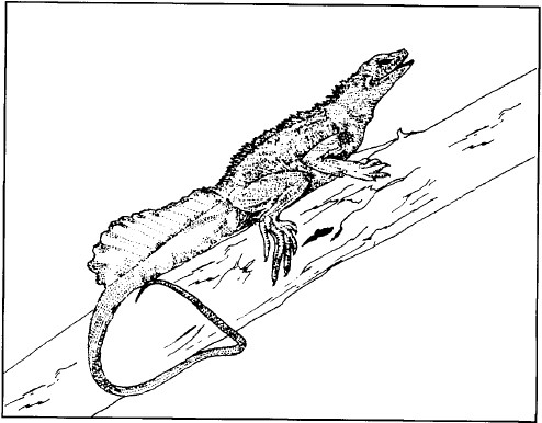
Figure 4.28. Sailfin lizard Hydrosaurus amboinensis.
After de Rooij 1915
Only one aquatic tortoise Cuora amboinensis is found on Sulawesi and nothing is known of its habits. It is likely, however, that only the young animals are wholly aquatic. It is generally brownish-black above and yellow with black spots below, although humic acids in the water can stain the yellow colour a reddish-chocolate.
Estuarine crocodiles Crocodylus porosus used to be very common in the lower parts of large rivers and early travellers reported seeing them in Lake Tempe (Mundy 1848), in the Maros River (Guillemard 1889), Lake Poso, Butaioda'a River (between Buol and Marisa) and the Dumoga River (Sarasin and Sarasin 1905). Their numbers were so high at the start of this century where the Onggak and Dumoga Rivers meet that it was impossible to cross from one bank to another, and nearby villages were surrounded by bamboo stake fences to protect the inhabitants at night (Sarasin and Sarasin 1905). Elsewhere, the abundance was not necessarily as high as imagined. Last century a bounty of $2 was offered for each crocodile killed and one resident of Maros was producing numerous animals and claiming his money. His technique was eventually investigated and it was found that he had fenced off a stretch of river within which crocodiles were living and breeding happily—and providing the gentleman with a significant income (Guillemard 1889).
Crocodiles are the largest animals found on Sulawesi. A skull found 90 years ago near Maros was 73 cm long indicating a likely total length of 5.5 m (Guillemard 1889). An EoS team was shown a crocodile skull 51 cm long (probable total length about 3.5 m) at the information centre of the western section of the Bogani Nani Wartabone National Park at Lombogo (fig. 4.29). The animal had been caught by villagers in 1985 in the middle reaches of the Bone River. More recently a 6.5 m long and 80 cm broad crocodile, which was said to have had human hair in its stomach, was captured near Malili. In some areas, crocodiles were traditionally not hunted because it was believed that the soul of dead humans went to live in them. An exception was made only when someone had been attacked and killed (Sarasin and Sarasin 1905).
The estuarine crocodile is capable of entering both saline and freshwater by virtue of physiological adaptations which allow it to control the osmotic pressure of its plasma. In an estuary or in the sea, crocodiles conserve water by reabsorption in their kidneys resulting in a very concentrated urine, and by reabsorbing water from their faeces before they are voided. Most salts are excreted in the urine (Grigg 1981) but sodium chloride is also excreted through their external nasal gland and glands in the corner of the eyes. When a female crocodile is ready to lay eggs, she seeks a shady location on land where she builds up a dome-shaped nest of leaves, tall grass or peat (Greer 1971). The eggs, up to 50 or more, are laid in the middle of this nest, where they remain damp and protected from direct sunlight. The heat generated by the decomposition of the vegetable matter probably helps the incubation, but if the mother senses the eggs are becoming too hot she will spray urine over the nest to cool it down. Just before the eggs hatch, the young crocodiles make high-pitched croaks which are audible outside the nest. The mother scratches away the now-hardened surface of nest material and as the young crocodiles wrestle their way out of their shells, she (and sometimes the father too) picks them up gently in her mouth and carries them away to a secluded 'nursery' area in a swampy bank. They stay there for a month or two, guarded by their parents, catching large insects and small vertebrates such as fish and frogs. As described for sea turtles (p. 155) the sex of hatching reptiles is determined by the temperature of incubation. Experiments on the Mississippi alligator, a reasonably close relative, have shown that alligator sex is fully determined and irreversible by the time of hatching. Incubation temperatures of up to and including 30°C produced all females, while 34°C and above produced all males. Temperatures in between produced clutches of mixed sexes. Since nests on exposed riverbanks or other dry areas receive more sunlight and are hotter than those nearer wet, shaded swamp, the sex ratios of hatchlings will be different between these habitats (Ferguson and Joanen 1982). It is likely that the sexes of estuarine crocodiles are also determined by incubation temperature, and this is important for management of the species. The clearing of riverine forest (p. 342) followed by regrowth of tall shrubs and grasses will reduce the amount of shading and may increase the average ambient temperature of an area. This in turn may increase the number of male crocodiles. However, the efficiency of nest temperature regulation by the female is unknown as are the social impacts of any alterations in sex-ratio.
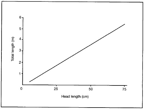
Figure 4.29. Relationship between skull and body length of estuarine crocodiles.
After Greer 1974
Nest sites are exposed to the warming rays of the sun for a major part of the day but because they are generally surrounded by relatively tall vegetation they are difficult (as well as dangerous) to find and count. For these reasons, surveys of nest mounds are best conducted from the air if light aircraft or helicopters are available. Nest sites have a number of common features: access to permanent fresh or only slightly saline water, seclusion, and proximity to the type of vegetation used in the construction of nest mounds. Where plant growth is abundant, nests are built in places where the plants can resist strong winds but can be flattened by a crocodile crawling over them. Such plants break easily or can be uprooted, and have foliage from the substrate level to the tip rather than a thin stem and foliage concentrated at the top (Webb et al. 1983).
Finally, Sulawesi has four species of brownish-grey freshwater snakes: Homalopsis buccata, Enhydris erthydris, E. plumbea, and E. matannensis. The last species, which grows to about 25 cm, is endemic to Sulawesi, has an olive-brown back and a yellow-white throat.16 It is known from only two specimens: one from Lake Matano and the other from a fish pond near Raha, Muna Island (Iskandar 1979), and its ecology is unknown. If it is similar in habits to its close relatives in the Malay Peninsula, however, it feeds on fish and frogs (Tweedie 1983). Other snakes are sometimes found in rice fields but these are terrestrial species with no particular adaptation for swimming.
Water Birds
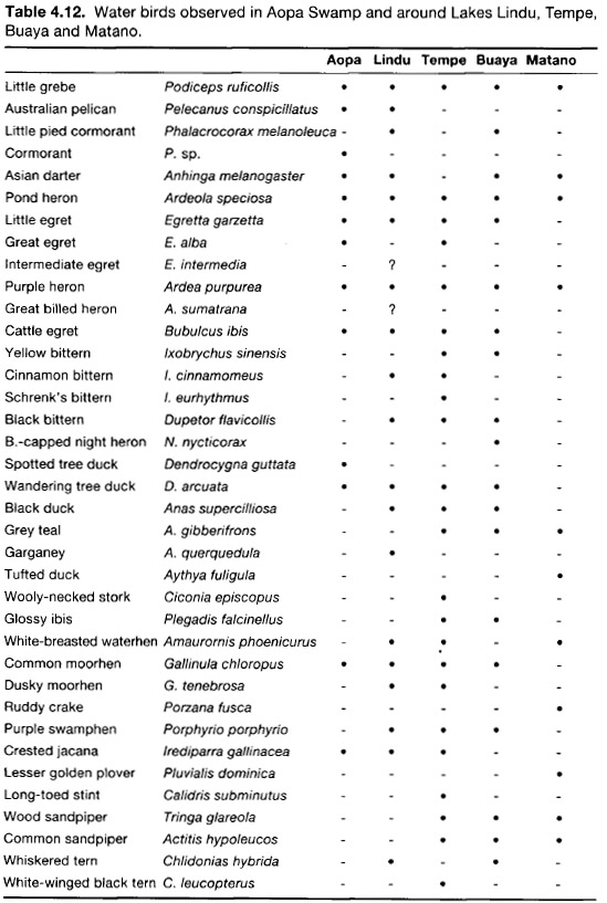
Water birds are far more common in Sulawesi than they are in western Indonesia probably because it is closer to the migration pathway of some of the species. Many of the larger birds such as the storks, egrets and herons are the same as can be seen at the coast (p. 149), but the Australian pelican Pelecanus conspicillatus (fig. 4.30) is found more usually near lakes. About 30 species of birds are associated with aquatic habitats and of these, most of the smaller ones are more or less confined to such areas (table 4.12).
In 1840 Lake Tempe was said to 'abound with aquatic birds' (Mundy 1848) and even now a large number of aquatic birds can be seen. An Interwader/EoS survey of lakes Tempe and Buaya in April 1986 found relatively few muddy habitats suitable for waders. A greater area becomes available in the dry season when local residents report an abundance of small waders. Even so, 29 species of water bird were found, the most for any area in Sulawesi so far (Uttley 1986).
The little grebe Podiceps ruficollis, a small, round, brown diving bird, is found both on large lakes and on smaller forest-fringed lakes such as those in Lore Lindu (even on Lake Tambing at 1,700 m a.s.l.) and Morowali National Parks (Anon. 1977b, 1981b; Watling 1983). Another diving bird is the Asian darter Anhinga melanogaster (fig. 4.31 on p. 306). It resembles a cormorant but has a longer, more slender neck and an unhooked bill.

Figure 4.30. Australian pelicans Pelecanus conspicillatus, one of the largest species of birds to be seen on Sulawesi lakes.

Figure 4.31. Asian darter Anhinga melanogaster, a diving bird found on lakes.
After King et al. 1975
Alter Escott and Holmes 1980; Holmes and Wood 1980; Watting 1983; Uttley 1986

Figure 4.32. Lakes of the Malili River system.
After Brooks 1950
Malili Lakes System
Endemism in the lakes of the Malili region (fig. 4.32) has been shown to be very unusual. The entire system is connected by rivers and contains three large lakes, Matano, Mahalona and Towuti, each downriver of the other, and two much smaller lakes, Masapi and Wawantoa.
Of the 100 or so species of copepods, prawns, molluscs, and fish endemic to Sulawesi found in the system, only two (a prawn and a goby) are shared by all five lakes (fig. 4.33). This has led to speculations of species arising within the lakes and rivers due to isolation resulting from waterfalls in connecting rivers or to physiographic obstacles not evident today. It is certain that further collecting would add to the species lists of the lakes and allow better hypotheses to be made concerning the origin of the fish, and would also better establish the status of the endemic species particularly in the light of the nickel mine and other human activities. It is very important that the remarkable biology of the lakes be better known and for the lakes to be given appropriate conservation which would prevent introduction of other fish.

Figure 4.33. Some endemic fish of the Malili lakes. Top row: Oryzias matanensis from Lake Matano; middle row: Dermogenys weberi from Lake Matano, Telmaterina bonti from Lakes Mahalona, Towuti and Matano; bottom row: Paratherina labiosa from Lake Wawontoa, Telmatherina celebensis from Lake Mahalona. The last species is also found in Lakes Wawontoa, Matano and Towuti but these differ somewhat in shape.
Alter Boulenger 1897a; Aurich 1935a, b, 1938
PHYSICAL PATTERSN IN LAKES
Most lakes can be viewed as slow-moving rivers in which the riverbed has become very wide and very deep. Many of the same species of animals and plants live in both lakes and rivers, and many of the adaptations they require are also the same. So different are the physical regimes of lakes and rivers, however, that their behaviour requires separate attention.
Temperature
The sun warms the surface of a lake and this can cause density differences within the water column to produce a layering effect (fig. 4.34). The warmest and highest layer, the epilimnion, experiences diurnal fluctuations: at Lake Moat the maximum daily range of water and air is temperatures is 21.5°-23.5°C, and 16°-23°C respectively (Buchari 1984). Temperatures for the surface water of other lakes are similar but decrease with increasing altitude (table 4.13). The narrower temperature range of water than air is due to water's superior capacity to retain heat. Maximum water temperature rarely exceeds that of the air except where hot springs are present, such as at the southwest of Lake Tondano, or where water is shallow such as at Aopa Swamp and Lake Limboto.
Temperature generally decreases with depth but there are exceptions such as Lakes Moat (EoS team), Towuti and Matano (Wardoyo 1978; Anon. 1980) where temperature appears to stay more or less constant throughout the depth of the lake. In one study at Lake Towuti the temperature at 135 m depth was even found to be 1°C warmer than at the surface (Wardoyo 1978). These three lakes are in areas that are tectonically relatively active and the temperature anomalies may be due to deep hot springs (Anon. 1980). These unusual temperature profiles may cause overturns of the water (p. 315), bringing deoxygenated water to the surface, but this has not been reported. The maximum temperature of surface water on Lake Tempe was 29°C, almost 5°C warmer than that recorded at Moat, because of the higher altitude and hence higher ambient temperatures at Lake Towuti.
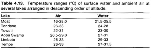
After Sarnita 1974; Achmad and Cholik 1977; Suwignyo 1978; Wardoyo and Thana 1978; Anon. 1979b; Thana and Wardoyo 1980; Thana et al. 1980; Buchari 1984

Figure 4.34. The three principal density layers of a hypothetical lake.
The metalimnion is an intermediate, relatively thin layer through which water temperature usually drops rapidly (as much as or greater than 1°C/m (Moss 1980), and this gradient is termed the thermocline.
The thermal characteristics of lakes should be examined over a longer period of time, perhaps 1-2 years, in order to assess any diurnal and seasonal variations. In deep, wind-swept lakes, a persistent stratification may never form (Moss 1980).
Oxygen
Dissolved oxygen concentrations are highest in the surface layers where photosynthetic activity of plants is greatest, and lowest at the lake bottom, where light is low and plants rare (table 4.14). An EoS team examined this in Lake Moat and found surface concentrations of about 7.9 ppm and bottom (9.6 m) concentrations of about 3.0 ppm.
Oxygen values varied with depth along all profiles, a phenomenon which could reflect micro-site variations caused by the mixing of water layers, or may possibly reflect populations of photosynthetic phytoplankton and bacteria. The deepest layer of a lake, the hypolimnion, is far removed from the two sources of oxygen—the atmosphere and green plants—and the organisms which decompose the faeces, corpses and other organic matter falling to the bottom, consume rather than produce oxygen. Oxygen concentrations in a deep lake may be reduced to zero. All lakes surveyed show concentrations of surface oxygen that were excellent for fish growth (table 4.16). The lowest concentration recorded was 1.5 ppm at the Aopa Swamp, which is too low for fish which rely solely on their gills for obtaining oxygen.
Nutrients and Conductivity
As has been described, the hypolimnion experiences a nutrient gain due to the rain of organic matter from above, while the epilimnion and metalimnion experience a nutrient loss. A profile of conductivity with depth can reveal approximately where nutrient gain, expressed as a higher concentration of dissolved materials, starts.
The oxygen consumption (rate of respiration) in lowland lakes in Sulawesi is about 4-9 times faster than it is in temperate lakes which are 15°-20°C cooler. Carbon dioxide and other solutes are released very quickly and in the deeper lakes much of the settling organic matter would probably be reduced to mineral matter before it reached the lake bed. The high concentrations of phosphate and ammonium in the hypolimnions of some lakes have led to the suggestion that it is these deep waters, rather than surface layers, that should be used for irrigation.
Figures for the chemical composition of Sulawesi lakes indicate a large degree of variation (table 4.15) but to what extent this represents genuine differences or simply reflects different methods of analysis is not known. Almost all measurements are from only the surface layers (probably 1 m or less) and results can also be compared with water quality criteria for fish (table 4.16).17 Lake Limboto has the lowest and highest values of carbon dioxide and pH respectively. Carbon dioxide concentrations were higher on the lake bed than in the surface layer, and in Aopa Swamp, water quality was poor, according to the criteria, as might be expected.

After Achmad and Cholik 1977; Wardoyo 1978; Wardoyo and Thana 1978; Pirzan and Wardoyo 1979; Thana and Wardoyo 1980; Thana et al. 1980; Anon. 1981a; and EoS surveys
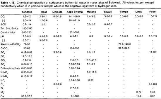
After Sarnita 1973; Anon. 1977a. 1978, 1979a, b, 1983a; Wardoyo 1978; Wardoyo and Thana 1978; Achmad and Cholik 1979; Pirzan and Wardoyo 1979; Thana and Wardoyo 1980; Thana et al. 1980; Buchari 1981
Lakes are frequently classified on the basis of nutrient loading, phytoplankton counts, and organic productivity. In general, the lakes of Sulawesi are oligotrophic, or nutrient poor, and their water is relatively clear, with plant growth restricted to a few meters from the shore. Lakes Moat, Poso, Matano, Towuti and Mahalona are in this category. Lake Lindu has an intermediate nutrient status (Sarnita 1973) termed mesotrophic, while Lakes Tempe, Tondano, Limboto and Aopa Swamp are eutrophic, rich in nutrients, supporting an abundant fauna and flora (p. 340).
Light Penetration
The depth to which light can penetrate is called the 'euphotic zone' and below this depth primary productivity is essentially zero (Cole 1983). The zone varies daily or seasonally. A standard, simple method of estimating light penetration is with the Secchi disk. This black-and-white plate about 20 cm in diameter is lowered into the water and the depth at which the plate disappears from the viewer's sight is recorded. The disk is lowered a bit further and the depth at which it reappears is also recorded. The average of these two readings is less than the actual depth of the euphotic zone, but represents approximately 30%-80% of it (table 4.17) (Cole 1983). As would be expected, oligotrophic lakes are much clearer than eutrophic lakes in which high concentrations of phytoplankton tend to absorb the light.
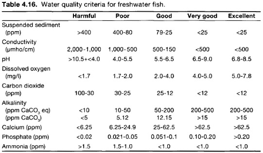
After Alabaster and Lloyd 1980; Anon. 1983a
Stability
Stability of tropical lakes is poorly understood, but may be very important. In general, warm waters have a greater resistance to mixing than cooler waters, and slow mixing may continue all the year round (Anon. 1982b). Overturns, in which the hypolimnion is brought to the surface, are not unknown however, and the low oxygen concentrations of water from the bottom of a lake can cause fish to perish if it comes to the surface (Green et al. 1976). Greatest stability is found in steeply walled, deep lakes with small surface areas (Anon. 1982b). Indeed, the relationship between surface area, thermocline and stability can be quantified roughly as follows (Ruttner 1931):
|
Area |
1: |
100: |
1,000 |
|
Depth of thermocline |
1: |
3: |
6 |
|
Stability (0- 20 m) |
50: |
10: |
1 |
Thus Lake Towuti, which has ten times the area of Lake Tondano, would have a thermocline twice as deep and require only one-tenth of the wind strength to mix the top 20 m. A strong wind-generated water current noted by an EoS team at Lake Moat could have caused sufficient mixing of layers to prevent layering. In the Philippine Lake Lanao, thermoclines shallower than 20 m depth are easily formed but equally easily disrupted by light winds, while at greater depths secondary thermoclines are more constant, requiring squalls or storms to dissipate them (Lewis 1973).
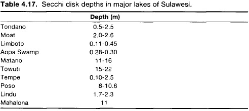
After Sarnita 1973, 1974; Wardoyo and Thana 1978; Anon. 1979a, b; Pirzan and Wardoyo 1979; Thana and Wardoyo 1980; Thana et al. 1980; Buchari 1984; and EoS surveys
Abiotic factors, particularly climate, are most influential in the process of change. Precipitation, for example, governs the volume and surface area of the lakes, temperature is the driving force behind chemical reactions and establishment of density layers, and wind induces layer mixing and increases surface concentrations of dissolved oxygen.
In lakes that do not mix completely, a type of chemical stratification may occur in which nutrients may be held in deep layers that resist mixing and are therefore unavailable for life in the upper lake layers. For example, in Lake Lanao, (Philippines), free nitrate levels were undetectable when the water column was stable, but seasonal circulation helped to distribute nitrate and other nutrients to the surface layers (Lewis 1973). It has been suggested that small year to year variations in the annual heat budget are the critical factors in the layer stability of lakes (Moss 1980).
BIOTIC PATTERNS IN LAKES
As would be expected, the distribution of biota in a lake is determined principally by the physical conditions, particularly the layers.
The distribution of plankton in lakes (and other bodies of water) is governed by a number of variables such as water density and viscosity, nighttime cooling, turbulence, temperature, light intensity and time of day. In addition, the form of feeding of zooplankton has an effect (Davis 1955). Differences in plankton abundance do not only occur between the epi-, meta-, and hypolimnion but considerable variation also exists within the epilimnion itself; these differences are not always easy to explain (Rut-tner 1931).
Many fish obviously depend on the plankton for food and would be unable to feed on them if they were in the hypolimnion because of the low levels of oxygen found there. Benthic animals either have to be able to cope with very little oxygen (such as the red, haemoglobin-filled chironomid fly larvae) or with no oxygen, and usually no light (such as anaerobic saprophytic18 fungi and bacteria). In the low-oxygen, dark environment these organisms have few predators.
PHYSICAL PATTERNS IN RIVERS
Variation exists across a river as well as down its length. Velocity and depth of water, and substrate composition all vary along and across a river and all influence the biota which may inhabit rivers.
Discharge
The volume of water flowing through a cross-section of river per unit of time is the discharge (Q), represented as the product of the mean velocity (V) and the cross-sectional area (A), or Q = VA. Thus, a wide, deep river with a cross-sectional area of 30 m2 flowing slowly at 0.5 m/s has the same discharge as a narrow (A=10 m2) river moving swiftly at 1.5 m/s (Q = 15.0 m3/s in both cases). It may seem strange, but the average velocity of a river is lower in the steep headwater regions than in the lowlands. This was demonstrated by an EoS team that measured velocity and discharge at stations at 1,440 m, 825 m and 0 m altitude in the Jeneberang River system. The velocities at those stations were <0.005, 0.12 and 2.99 m/s and the discharges were <0.1, 0.4 and 3.3 m3/s respectively. Discharge thus increases as the river flows downhill, though this is to be expected because of additions from tributaries and from water flowing into the river from runoff and interflow. An EoS team monitored rainfall and discharge at a small river in the headwaters of the Jeneberang River over a period of 18 consecutive days. Rain occurred in the first week only (fig. 4.35). Discharge is clearly not dependent solely on rainfall because of complicating factors such as previous rainfall, and intensity and duration of rainfall. Each watershed, and each area within a watershed, will respond differently to rainfall and so discharge is changing along the course of a river, and at any particular point (Achmad 1983).
Heavy rains can produce dramatic increases in water levels in rivers. At the Toraut River, near Dumoga, the high water mark is over 1 m higher than for low flow, representing a 300% increase in discharge. The concomitant increase in energy of the flow during a rainy season often places extra stress on benthic organisms and plants. Turbulent flow scours river-banks and carries soil, rocks, and even whole trees far downriver. Extremely large floods may even permanently alter the river course.
Headwater streams respond quickly to short, intense rainfall, whereas the response of wide, lowland rivers are much slower. For example, the time lag between rainfall and discharge peaks at 300 m altitude on the Jeneberang River is about seven hours (Anon. 1984).
The flash flood is a dangerous event characteristic of small rivers on steep slopes or other channels which are usually relatively dry. High intensity rainfall may cause a rapid rise in river levels, which can suddenly appear as a single flood-wave travelling swiftly downriver. This happens because waters from small feeder channels meet and concentrate in a larger channel simultaneously, or when water pooled behind an obstacle such as a dam or a fallen tree suddenly breaks free and gushes downriver. Flash floods occasionally occur in the normally dry riverbeds leading to Palu Bay after rare heavy storms have broken over the mountains. The water surges with great force carrying enormous quantities of suspended sediment. Surprisingly large boulders are also brought down to the lower reaches of the river. The comparative rarity of these events is shown by the herbs and shrubs growing on the dry riverbeds which would get swept away in a flood. The unsuspecting traveller crossing the river can easily be swept away or hit by transported debris.

Figure 4.35. Rainfall and average discharge of a river at 1,440 m over a period of 18 consecutive days.
Data from an EoS team
The 'lahar' is an Indonesian term that refers to mudflows due to volcanic activity. Lava, soil and water mix together to flow downslope in much the same process as the flash flood previously described. Sufficient water must be available to move the mass, either from rain, a lake or river. Lahar paths are evident on the flanks of Mt. Karangetang on Siau Island and Mt. Lokon, near Manado. On Mt. Karangetang, it appears that lahars join the main river which eventually discharges into the sea.
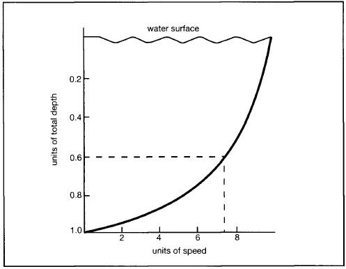
Figure 4.36. Relationship between current velocity and depth in an open channel. Average velocity is measured at 60% of the total depth.
After Townsend 1980
Shear Stress
Shear stress is the result of faster water flowing past slower water. This is described by the velocity gradient (fig. 4.36) which has a logarithmic distribution. Velocity is greater in the main body of flow just under the surface than at the riverbed or the shore boundaries. Turbulent flow near the water surface may create eddies the resultant energy of which moves particles on or near the riverbed. Pebbles or rocks are lifted up, pushed or bounced along, bounced into other rocks or thrown into faster water layers, only to settle down once again on the riverbed (fig. 4.37). The greater the shear stress on the riverbed the greater the chance that a benthic organism will be dislodged and washed downstream. Shear stress is proportional to water depth and to slope, and much greater shear stress will be experienced by benthic organisms in the headwaters, than by similar organisms in the lower reaches.

Figure 4.37. Particles on a riverbed can be pushed along, rolled, bounced or carried along.
Riverbed Particle Size
Rivers are capable of carrying sediment of all sizes ranging from the smallest clay fractions to large boulders. The particles that travel along the riverbed will be those that are larger than the flowing water is able to carry away. The smallest particles are the suspended load while the larger particles rolled along the riverbed are the bed load. As shear stress decreases downriver, so the average particle size of the suspended load decreases, larger particles having fallen to the riverbed. Thus the particle size on the riverbed also decreases downriver. Particle sizes of suspended load typically range from clay (<0.004 mm) to sand (<2 mm), although much larger rocks and pebbles may also be suspended for shorter periods of time. The diameter of a particle in suspension is, however, generally less than 0.5 mm (Dunne and Leopold 1983). The amount and type of sediment suspended in a river is related to the type and exposure of sediment sources, such as slopes, riverbanks and roads, as well as to discharge.
Discharge rates are often used to estimate suspended sediment concentrations, but caution must be exercised. This relationship is unique to each river under a certain set of conditions and cannot be transferred to other rivers or even used for the same river, if large areas in the catchment area are to be developed or disturbed. There are complications too, in that for a given discharge there may be more, or less, suspended sediment when the river level is rising than when the river level is falling. This will depend on erosion sources in the river basin and the predominant flow processes.
Bed load consists of larger particles that are rolled or pushed along the riverbed. These can become suspended briefly but the weight of the particle soon pulls it back down. Bed load is difficult to measure and no data are available for Sulawesi. Depending on rainfall patterns and watershed characteristics, bed load may account for as much as 50% of the total load (Dunne and Leopold 1983), although it is more typically suspected as being much lower. The bed load component is commonly omitted and this can result in a serious underestimation of the total sediment load.
Temperature
Altitude, rain, exposure, water source and velocity, and ambient temperatures are the major factors which influence river water temperatures. For example, the surface temperature in an exposed section of the Banti-murung River measured by an EoS team, was 27°C, whereas under shade just 5 m upriver, the surface temperature was 26°C, and in a nearby swiftly-moving tributary, water discharged from a cave was even cooler, at 25.5°C. The temperature of five different lowland rivers in the Southeast Sulawesi ranged from 26°-29°C. This is rather less than the temperature range of 25°-32°C found in Malaysian lowland rivers (Chye and Furtado 1982) but more samples would doubtless increase the range.
Temperature layering, such as found in lakes, does not occur to any extent in rivers because the water is in continuous motion and depths seldom exceed 2 m. Water temperatures can respond quickly to ambient air conditions however, particularly if the river is shallow and slow moving, a situation typical of lowland rivers. A river less than 2 m deep in Sri Lanka displayed a diurnal variation of 5°C, ranging between 25o-30°C (Benzie 1984). Night-time temperatures of water remain warmer than air temperatures due to the warming effects of surrounding earth and ground water seepage, and to the greater thermal capacity of water (fig. 4.38). Rivers at higher altitudes are cooler due to the lower mean daily air and soil temperatures (p. 489).
Dissolved Oxygen and Mineral Nutrients
Oxygen concentrations of lowland rivers are generally about 6.5 ppm to 7.5 ppm although sluggish rivers may have a concentration of only about 4 ppm. Concentrations in mountain headwaters tend to be greater because the water is more turbulent and because cooler water can hold more oxygen (Chye and Furtado 1982).
Solubility of gases, including oxygen, decreases with increasing temperature. At the same time, the rate at which oxygen is consumed through oxidation of organic compounds (BOD), rises. Thus, a river suddenly exposed to greater sunlight and hence higher temperatures due, for example, to riverbank clearing, will experience a dramatic chemical change, possibly even resulting in the death of fish (Johnson 1961; Anon. 1982a). In addition, reduced light penetration in rivers caused by high concentrations of suspended sediment levels would restrict photosynthesis of algae and other plants and would thus result in lower oxygen concentrations.

Figure 4.38. Changes in air and water temperatures in the headwaters of the Jeneberang River at 1,440 m altitude.
Data from an EoS team
In general, lowland rivers have low concentrations of chemical ions, weakly acid pH, low alkalinity (and therefore low buffering capacity), low BOD, and low mineral nutrients, especially phosphate and nitrate (Chye and Furtado 1982). Exceptions occur where human activities influence water quality (Palenewan 1984). Concentrations will vary with river volume and dilution is not always the major factor. An examination of water quality in the Jeneberang River revealed that concentrations of magnesium and potassium were much higher in the rainy period than the dry period, due to release of these cations from soil particles washed into suspension.
BIOTIC PATTERNS IN RIVERS
The abundance of many organisms changes along the length of a river, and some organisms are found only in mountain headwaters whereas others are found only in the estuary. These different distributions are largely determined by the physical factors described above. A study of fish diversity along a Malaysian river found an increase with river 'order' (Bishop 1973), but a similar study in the United States found that maximum richness was in the middle orders (Minshall et al. 1985).
Current
Shear stress is greatest in turbulent headwaters and organisms found in these waters have attachment adaptations to prevent them from being swept downriver. For example, plants of the headwaters tend to have low resistance to water flow, good anchoring ability, and high resistance to abrasion. They include encrusting algae, mosses and filamentous algae and occasionally a group of higher plants which are taxonomically diverse but show similar structural features. These plants are known as 'rheophytes' and are typically shrubs with narrow leaves and brightly-coloured fruit dispersed by water or fish (Whitmore 1984). They are not, however, particularly well represented on Sulawesi (van Steenis 1981).
As the discharge, and hence the water velocity and shear stress, varies with time and at any given point, plants are adapted for maximum flows (Townsend 1980). Plants growing near the edge of a river are subject to less shear stress and so the density of plants and composition of a plant community will vary across the river. Even so, floods also sweep away large amounts of algae attached to stones although they also bring down detritus from further upriver. It is therefore more advantageous for an animal to have a dependence on detritus than on algae growing on stones (Dudgeon 1982a). Bed load movements can drastically alter rock or riverbed environments of benthic dwellers, while suspended loads influence light penetration and photosynthetic opportunities of phytoplankton and bacteria.
Many invertebrates and fish of the headwaters have extremely flat bodies allowing them to move about easily in the almost motionless layer of water just above the riverbed, or to live under stones. Some have hooks, others suckers, and yet others have hydrodynamically streamlined shapes. Some of the fish living on the riverbed are able to maintain their position by having a smaller swim bladder (an air-filled sack in their bodies used to control buoyancy) than that found in fish that are adapted for swimming against the current.
The distribution and abundance of animals found on the riverbed across a meander, will reflect differences between the inner (slow-moving) and outer (fast-moving) bends. For example, species of net-spinning caddisflies (p. 292) that make strong coarse-mesh nets to catch passing food are found in the fast-flowing, shallow parts of a river, whereas the species with finer and more delicate nets are found in the slower, deeper water (Dudgeon 1986b).
Substratum
The trend of decreasing particle size on the riverbed with increasing distance from the headwaters obviously influences the distribution of animals. For example, those adapted to living under stones will rarely be found on a muddy substrate, and those which burrow into mud will not be found among stones. It is interesting, therefore, to consider the effects on animal distribution of the common practice of removing small boulders from riverbeds for use as hard core in making roads and other constructions.
Rooted macrophytes may be found in parts of a river where conditions are suitable (relatively slow-moving with sufficient silt and organic material), and these in turn influence the distribution of invertebrates. Most invertebrates found on macrophytes do not feed on the plants themselves but graze on epiphytic algae growing on the leaves (p. 288) a situation which has parallels with seagrass meadows (p. 208). Other invertebrates use the leaves as an anchorage point from which to filter water for particles of suspended organic matter, and yet others are predators.
TEMPERATURE AND DISSOLVED
Oxygen
It was shown above (p. 311) that temperature and concentration of dissolved oxygen are closely related. Temperature increases with distance from the headwaters, but it is somewhat difficult to distinguish any effect this may have from the linked effect of decreasing dissolved oxygen. The fall in dissolved oxygen concentrations downstream is exaggerated because the oxygen removed from the water by organisms living in the calmer, lower reaches is less easily replaced than in the turbulent headwaters.
Studies of environmental changes and their effects on aquatic organisms have tended to concentrate on pollutants and other chemicals, whilst the importance of temperature is often overlooked. The metabolic rate and hence demand for oxygen of most animals increases with temperature, but at higher temperatures haemoglobin has a lower affinity for oxygen, and dissolved oxygen concentrations decrease.
An increase in temperature from 25°-30°C resulting from the clearing of riverine forest, for example, would cause a 9.5% reduction in dissolved oxygen at saturation and the saturation percentage will probably also fall (Crowther 1982). This will have marked impacts, particularly on animal communities, although tolerance of oxygen depletion varies between species. In general, however, indigenous species are less able to cope with changes than introduced species.
Mineral Nutrients
Most aquatic molluscs are limited in the freshwaters they can inhabit because they need calcium concentrations in the water of at least 20 mg/l for the secretion of their shells. As a result, rivers running off relatively recent volcanic debris, for example, are likely to support few, if any, molluscs although this effect needs to be quantified. Some molluscs, however, appear to get all the calcium they need from their food and can therefore live in water with much lower calcium concentrations.
Pulmonate snails, those with accessory breathing organs, tend to have greater tolerance of turbidity, low dissolved oxygen, water hardness, pH, ammonia, nitrates and phosphates than many of the prosobranch snails which are more particular in their choice of habitat (Palmieri et al. 1980). Exceptions do exist and a good example is Melanoides tuberculata which is tolerant of a wide range in water quality (Dudgeon 1986a).
Biotic Factors
Competition between species and predation may be the main factors constraining a particular species to its realized niche rather than its preferred or fundamental niche. Where this shift is caused by direct aggression, interference competition is said to have occurred. A second form, exploitation competition, is less easy to identify but occurs where indirect competition occurs for the same resource. Consumption of that resource by one species will reduce the amount remaining to be consumed by the other species. The species less able to convert the resource into reproductive output will either perish, move elsewhere, or specialize in other resources. Thus the diet, habitat preference and habits of a community of 20 freshwater fish species in Sri Lankan forest rivers was examined and it was found that, with a few exceptions, the niches occupied overlapped little. Where species appeared to live in similar microhabitats, it was found that their diets differed (Moyle and Senanayake 1984).
Energy Flow
At the level of communities or whole ecosystems, the study of ecology can be broadened to include the flow of energy through the ecosystem, in which organisms are regarded as transformers of energy. The energy base in most ecosystems is provided by plants converting solar radiation through photosynthesis into high-energy organic molecules. Exceptions are caves (p. 535) where there is not enough light for green plants, and rivers in which a substantial proportion of the energy base is represented by decaying organic matter. This organic matter can be divided into two components: 'allochthonous' (originating outside the system) and 'autochthonous' (originating within the system). The latter is a relatively minor component. The available organic matter, living and dead, is processed by a wide range of organisms, which include bacteria, fungi, invertebrates and fish, all interacting in a highly complex manner (fig. 4.39) with different pathways depending on the size of the particles. The organic particles can be divided as follows:
• dissolved organic matter (DOM) arbitrarily defined as smaller than 0.00045 mm diameter,
• fine particulate organic matter (FPOM), less than 1 mm diameter, and
• coarse particulate organic matter (CPOM), more than 1 mm diameter and including whole leaves, twigs, etc. The FPOM and CPOM components also include the micro-organisms associated with them (Townsend 1980).

Figure 4.39. A simplified model of energy flow in a river ecosystem. To preserve clarity some arrows have been omitted. For example, all the animals contribute to FPOM in the form of faeces, dead bodies, etc.; some of the allochthonous input contributes directly to FPOM; the principal food of many fish in rivers consists of invertebrates so the 'predator' category includes fish. However, some fish feed on macrophytes and detritus.
After Townsend 1980
The path of the energy flow depends to a large extent on the nature of the energy base. The majority of river headwaters, particularly if undisturbed by people, flow through forested catchment areas and receive a substantial allochthonous input from material that simply falls into the water from the forest canopy (fig. 4.40). This decomposes extremely rapidly in tropical rivers, and a proportion of the nutrients released return to the terrestrial vegetation through the roots that trail in the water (Dudgeon 1982a, 1983c). Consistent with the knowledge that the fauna of shallow, stony and fast-flowing 'riffles' is different from that of deep and slow-flowing pools (p. 323), so rates of decomposition also appear to be higher in the riffles (Dudgeon 1986b). The shade provided by overhanging trees prevents, or at least hinders, the growth of both attached algae and macrophytes, but lower down the river only the riverbanks are shaded and the autotrophic component increases. The attached algae component, which is generally better adapted to extreme flows and less dependent on a substrate of sediment, would be expected to fill its maximum role nearer the headwaters than the macrophytes. Both macrophytes and attached algae should continue to make significant contributions to the river energy budget, until the depth and turbidity are such that light can no longer reach the riverbed, and then these plants will be restricted to the margins (Townsend 1980). Phytoplankton will usually make a significant contribution only where the river is long enough for this component to build up. The generation time for phytoplankton is one or two days (at least three or four days and frequently more for zooplankton), and since rivers generally flow between 20-60 km per day, it is clear that few rivers will have well-developed populations of phytoplankton (table 4.2).

Figure 4.40. Hypothetical representation of the relative contributions of potential energy inputs to a river.
Alter Townsend 1980
Such longitudinal patterns have not been studied in Southeast Asia. The scheme illustrated is hypothetical but it seems to fit the known facts from other regions. If it applies to Sulawesi it can be seen that forest clearance in headwater areas can seriously disturb a river's energy input and therefore the life that depends on it (p. 342).
Benthos Dynamics
When a heavy fall of rain causes increased flow, the shear stress exerted on a particular area of riverbed intensifies and the substrate is scoured, often with the loss of organisms associated with it. As the flow subsides, so organisms from upriver will be deposited in their place. Even when the river flow is normal, however, benthic organisms temporarily join the plankton and move downstream. This is easily demonstrated if a net is placed in a river and held above the riverbed for a period. This phenomenon is called 'invertebrate drift'.
In just 24 hours in a major headwater river in Peninsular Malaysia, an average of 222,800 individual invertebrates would drift past a transect (Bishop 1973; Townsend 1980). This is equivalent to about 160 individuals per 100 m3 of discharge. Drift varies not just with river flow but also through the day. Studies from various parts of the world have shown that drift is highest at night, particularly just after sunset (Bishop 1973). This appears to be related to light levels rather than to chemical changes. Many invertebrates spend much of the day hiding under stones and only forage when darkness falls. It is logical that when they start to move they are more susceptible to being swept away. It has been calculated that 2.6% of benthic invertebrates shifted their position each day by drifting (Townsend and Hildrew 1976) but another study showed that 60% of drifting invertebrates travel for less than 10 m before regaining a foothold (McLay 1970).19
Whether or not losing contact with the riverbed and drifting downriver is accidental, there may be adaptive significance in doing so. A riverbed, as with most habitats, is composed of 'patches', some favourable for a particular organism and some unfavourable. The patch may be a food resource, a form of favoured substrate, an area experiencing a certain set of biotic and/or abiotic conditions, etc. In some cases a patch may change its suitability, for example, when a food resource is depleted or when a flood occurs (Bishop 1973; Townsend 1980). Drifting, although it has certain risks, is an energy-efficient way of moving from an unfavourable to a possibly favourable patch, for a journey of 10 m along a riverbed is not inconsiderable for many river invertebrates. For an insect larva 1 cm long it would be equivalent to 1,000 body lengths which for a man would be equivalent to about 1.7 km. If the drifting invertebrate lands on an unsuitable substrate there is a high probability of the animal re-entering the drift within 5-30 minutes (Walton 1978), suggesting that invertebrate drift is not entirely passive.
If such large numbers of normally quite sedentary animals are moving downstream, it would be reasonable to ask how the upriver regions remain populated. Do upriver movements by some organisms compensate for the downriver losses?
The displacement of organisms downstream does not necessarily lead to the extinction of those species in upriver stretches. One way to view drift is as a dispersal mechanism for removing animals (possibly as eggs or as larvae) which, had they stayed in the headwaters, would have exceeded the habitat's carrying capacity. It is obvious that not all young invertebrates could remain in the area where their eggs were laid because they would soon exhaust the initial food resource (Peckarsky 1979).
This is not the whole story, however, because an organism drifting downriver is likely to leave its zone of most suitable environmental conditions. It would therefore be reasonable to suggest that adult invertebrates that managed somehow to reach regions upriver of their optimum habitat to breed, would have an evolutionary advantage because their young would have a greater chance of developing in that optimum habitat (Townsend 1980). A 'colonization cycle' is thus envisaged with eggs being laid in the headwaters, dispersal of larvae occurring downriver and an upriver flight or other movement of adults to the headwaters to complete the cycle. This is commonly known as 'Mueller's hypothesis'.
The first two stages of this hypothesis are irrefutable but evidence for the upriver movement of adults is less convincing. Twin traps set to catch insects flying upriver and those flying downriver along a headstream river in Peninsular Malaysia revealed that the predominant direction of flight was in fact doum river (Bishop 1973). As a rule, winged adults of invertebrate species with aquatic larvae are not strong fliers and their flight direction might simply reflect the prevailing wind direction. Strong winds occur most frequently in rainy seasons and these are the periods when insect dispersal is most common (Fernando 1963). Adults of invertebrate species which spend their entire life cycle in freshwater are not usually strong swimmers or walkers but they may travel near the river edge where shear stress is least, so that the upriver journey requires the least possible energy. Most studies have found that upriver movements represent only about 7%-10% of the individuals that move downriver (Moss 1980; Williams 1981). It must be remembered, however, that if only a single female reaches the upriver regions, she may lay hundreds or even thousands of eggs.
The study of invertebrate drift deserves more attention. If an industrial development is to be sited in the middle stretches of a river, and an environmental impact statement has been requested before it is built, one of the many problems that should be considered is the impact on the recol-onization of upper stretches of the river by invertebrates (or, for that matter, fish). Is the effluent going to be poisonous or debilitating to adults moving upriver? Which months are the most critical? Since invertebrates are common food for fish, and fish are common food for humans, the problem of the mechanism of invertebrate drift is wider than that of esoteric biology.
FISHERIES
As indicated earlier (p. 298) the fisheries of Sulawesi's lakes are based not on indigenous species but on those ten introduced species that were thought to be most likely to succeed in the prevailing conditions (table 4.18; fig. 4.41).
A reflection of the different properties the of lakes is shown in the relative success of different introduced fish species. Oreochromis mossambicus has been extremely successful in Lake Lindu and Poso but only in Lake Poso has carp, an extremely difficult fish to introduce successfully, become the major harvested fish (Simanjuntak 1981). In oligotrophic lakes such as Matano, the carp Cyprinus carpio has not thrived and so there are plans to introduce culture nets moored off-shore in which the fish will be fed by hand. This method has been used with success in the Jatiluhur reservoir in West Java (Anon. 1980) and a similar method is used on Lake Tempe with another species, but the fish are released at the start of the rainy season.
The catfish Clarias batrachus is often regarded as undesirable in some areas because it preys on small fishes and is not favoured as a food fish. There are areas of Indonesia, such as Central Java, however, where this fish is in high demand (A. Hardjamulia pers. comm.). Catfish studied in Lake Tondano were found to feed primarily on detritus with molluscs and insects eaten occasionally. Introduced possibly only ten years ago, it has reproduced prodigiously probably because of an open niche, a wide range of suitable foods, high reproductive potential and little desire on the part of the local people to eat the fish. It has been suggested that ways to put pressure of the catfish populations should be found (Lumingas 1983).
The air-breathing Helostoma temminckii was so successful in Lake Tempe that it was being exported just twelve years after its introduction. But even more dramatic was the replacement of H. temminckii by the barb Barbodes gonionotus20 and the small gurami Trichogaster pectoralis which, two years after their introduction in 1937 were accounting for 20% and 70% of the lake's harvest respectively (Hickling 1957). As is often the case with lakes into which exotic fish have been introduced, the production in the early years was enormous, up to 25,000 t/yr. It fell to about 5,000 t/yr but is now about 12,000 t/yr (equivalent to about 600 kg/ha/yr). This is still a large annual production; for comparison, the production of fish in Aopa Swamp is only about 3 kg/ha/yr which is very low for eutrophic/mesotrophic waters, because even the deep oligotrophic waters of Lakes Matano and Towuti have a fish production of 6.5 and 4.5kg/ha/yr respectively. The low productivity of Aopa Swamp is at least in part because the people around the Aopa Swamp do not eat the abundant eels Anguilla tricolor21 and Monopterus alba (fig. 4.42) or the very common large Vivipara snails, despite these being common foods elsewhere in Indonesia. The high productivity of Lake Tempe is primarily a result of the gently sloping banks and the shallowness of the lake, as well as the balance between herbivorous and carnivorous fishes (Anon. 1977a). Carnivorous animals are far more wasteful of primary production than herbivorous ones.
The fall in fish production of Lake Tempe stimulated considerable research into the fisheries and other aspects of this lake which has been called the 'Fishbowl of Indonesia' (Suwignyo 1979). The first study of the problem had concluded that the dramatic decrease was due to the gradual shallowing of the lake (p. 258), but teams from BIOTROP in Bogor concluded that overfishing, together with some effect from shallowing, was the major cause (Anon. 1978). The local government responded to the conclusion by instituting Friday as a closed fishing day, and by proclaiming 230 ha in the centre of the lake as a fish reserve. Lack of effective enforcement meant that both these rules were flouted. More effective than such regulations would probably be the land-based enforcement of outlawing small (< 2 cm) mesh nets. Reduction of soil erosion from the water catchment area would also be beneficial. A further component in fisheries management would be to place an obstacle between the lake and the sea preventing milkfish Chanos chanos and other brackish water species from entering the lake. All these species (except Mugil sp.) are at least partly carnivorous and have a low combined production (Anon. 1978). While this course of action certainly seems reasonable from the point of view of inland fisheries, it might, when considered with the loss of mangroves, have serious effects on inshore and tambak fisheries (p. 187).

|
* = accidental introduction |
+ = date of introduction unknown |
|
(+) = known to have been introduced but no longer present |
|
After Schuster 1950; Sarnita 1973, 1974; Suwignyo 1978; Carney et at. 1980; Hadiwijaya 1981; Manggabarani 1981; Simanjuntak 1981; Lumingas 1983; A. Hardjamulia pers. comm.

Figure 4.41. Major introduced commercial fish of Sulawesi, a - Java barb Barbodes gonionotus, b - common carp Cyprinus carpio, c - rice-field catfish Clarias batrachus, d - two-spot gourami Trichogaster tricopterus, e - no-spot gourami T. pectoralis, f - gourami Osphronemus goramy, g - common tilapia Oreochromis mossambicus, h - Nile tilapia Oreochromis nilotica.
After Mohsin and Ambak 1983
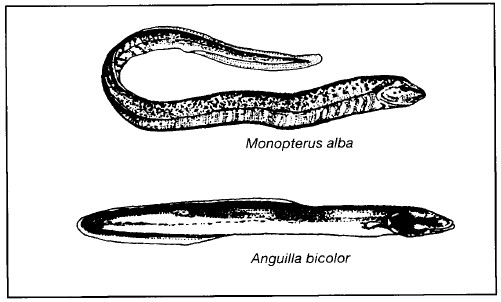
Figure 4.42. Common eels.
After Mohsin and Ambak 1983
Lake Limboto has also experienced a five-fold reduction in fish harvest, at the same time as the lake has become shallower (fig. 4.43), but not enough data are available to be able to state with any certainty whether this is due to the shallowing process or to overfishing.
Overfishing can be said to occur when the rate of harvesting exceeds the rate of recruitment or production. The recruitment rate varies with the size of a population, being low both when there are few individuals, and also when the population is crowded and competition between individuals is intense. When the carrying capacity of a habitat is reached, recruitment is zero (fig. 4.44).

Figure 4.43. Fish production, lake depth and area of Lake Limboto.
Data from U. Alitu pers. comm.; A.H.J. Purukan pers. comm.
Harvesting of a population can be conducted at three general rates which for the purposes of this discussion are assumed to be constant. When the harvesting rate is high and exceeds recruitment, then the population is driven to extinction. When the harvesting rate is low, then there are two points where the number of individuals lost to the population equals those recruited to the population. At this low rate, there is an equilibrium at a relatively high population density, and another at a relatively low population density. The latter is dangerous from a management perspective because if the population gets smaller due to some factor other than harvesting, yet the harvesting rate is maintained, then the population will be driven to extinction. The intermediate case is that where the harvesting rate exactly matches the maximum population recruitment. This is known as the 'maximum sustainable yield', which is balanced between the conditions of under- and overexploitation. As with the low harvesting rate, however, whereas higher populations are pulled back to the equilibrium point, lower populations are driven to extinction if the harvesting is not adjusted accordingly.

Figure 4.44. The effects of constant harvesting rates on the rate of recruitment to a population (curved line). There are three harvesting rates, high, medium and low. Arrows indicate the expected changes in population size under the respective harvesting rates. Dots indicate points of equilibria. The three rates have one, two and three points of equilibria respectively including the equilibrium of extinction. 'CC' indicates the maximum population allowed within the carrying capacity of the habitat. 'Nmsy' indicates the population size that can be harvested for a maximum yield on a sustainable basis.
The concept of maximum sustainable yield is central to the science of wildlife management, but it has many shortcomings. First, it does not take account of population structure such as the relative abundance of different age-classes; second, the environment varies and unpredictable events can cause reductions in populations unrelated to harvesting pressure; and third, the maximum sustainable yield is extremely hard to estimate since it requires detailed knowledge of population size and recruitment. Given these limitations it is usually necessary to make the best-possible judgement. This is true for fisheries management both in Lake Tempe and in some of the intensively-studied fisheries in North America. The usefulness of maximum sustainable yield is probably more important as a concept urging caution, and encouraging flexibility over harvesting rates that can be benign one year and catastrophic the next.
Even without the influence of people, however, fish populations do not necessarily remain static. For example, fish yields from Lake Moat increased between 1977 and 1981 (Buchari 1984), but reports given to an EoS team by local fishermen indicate that yields have since dropped, for example, eel catches have dropped from 50 per day to just 1 per month. The cause of this has not been investigated but local fishermen are of the opinion that there are simply too many fishermen. Also, yields from Lakes Lindu and Poso appear to be extremely unstable, but even in good years the yield is below that estimated as the potential yield. Migratory eels Anguilla spp. are indigenous to Lakes Lindu and Poso, but whereas eel fisheries are still active at Lake Poso (Taufik et al. 1980), they are now rarely found in Lake Lindu.
MANAGEMENT OF MACROPHYTES
Macrophytes can be extremely useful plants. They often provide important refuges for young fish, and they act as substrates for invertebrates and algae that are eaten by fish. Their presence in a body of freshwater is clearly important to a fishery. Some macrophytes, notably kangkung Ipomoea aquatica (Conv.), are eaten by people and fisherman around Lake Tempe deliberately plant this plant both for food and for the protection its hanging roots provide for young fish (Anon. 1977a). Some species, such as Hydrilla verticillata and water hyacinth Eichhornia crassipes are harvested for feeding to cattle, pigs, ducks and chickens (Swarbrick et al. 1982).
E. crassipes, Salvinia, Lemna and H. verticillata are also known to be efficient accumulators of nutrients and have been used in water treatment plants to lower nutrient concentrations in nutrient-rich water (Wolverton 1985). H. verticillata is useful as a 'sink' for nitrogen, phosphorus and zinc, whereas Salvinia molesta is particularly efficient at accumulating copper and lead (Finlayson et al. 1984).
Emergent and floating macrophytes can also be viewed as extremely disadvantageous. Water evaporating and transpiring from the leaves of emergent macrophytes (evapo-transpiration) may exceed the rate of evaporation from open water of the same area. This is an important consideration particularly in shallow lakes such as Tempe, Limboto and Tondano. This water loss may be expressed as evapotranspiration (Et)/evaporation (E). Et/E values for E. crassipes and S. molesta are 2.5-7.8 and 2.0, respectively (Sastroutomo 1985). That is, the active process of transpiration results in at least twice the water loss as evaporation alone.
From the viewpoint of fisheries, aquatic plants are disadvantageous in that they introduce considerable quantities of organic matter into the water which can lead to reduced oxygen concentrations. They speed the process of sedimentation by retarding water flow, thus enhancing deposition of suspended particles, and they interfere with fishing activities by snagging on fishing lines or getting caught in nets (Anon. 1983a). Since they reproduce vegetatively very quickly and are difficult to control, they are frequently referred to as 'weeds'. For example, the area covered by the floating Salvinia molesta can double in extent every 2.2 days under optimal growth conditions (Mitchell 1985).
The major Sulawesi lakes each have between one and four species from the list of the world's ten worst aquatic weeds (table 4.19). It must be remembered that 'weediness' is simply an attribute given to a plant by man; a weed is a plant growing where it is not wanted and the nomination of a plant as a weed is a consequence of man being thwarted in his ever-increasing attempts to manage his environment.
At Lake Tempe, Hydrilla verticillata, Ceratophyllum demersum, Najas indica and Potamogeton malaianus (Pota.), Polygonum spp. (Poly.) and Ipomoea aquatica (Conv.) are listed as potential sources of interference in the fishing industry there (Anon. 1978). Most of the above species, along with 26 emergents including Monochoria vaginalis (fig. 4.45) at the sides of Lake Tondano serve to slow the water current and increase sedimentation such that the lake is rapidly becoming shallower (Anon. 1979b).
In 1976 Eichhornia crassipes and Salvinia mokstawere not found on Lake Tempe although both are now present. Pistia stratiotes was present but was not regarded as a threat because it is not adapted to surviving periods of being washed up on the shore or stranded on the mud during the dry periods. Hydrilla verticillata is the major threat but even this appears to be restricted to the more sheltered parts of the lake, where the sediment is not so disturbed by water movement. This is probably also the reason why Najas indica and Ceratophyllum demersam are not more common. Changes proposed by water engineers to control the water entering and leaving the lake would diminish the sediment load and slow down the process of shallowing, but this would inevitably increase the abundance and distribution of most of the potential aquatic weeds since the water level fluctuations do serve to control these plants (Suwignyo 1978).

After Soerjani 1978, 1985

Figure 4.45. Monochoria vaginalis.
After Backer 1951
Macrophytes clearly have potential advantages and disadvantages with respect to human uses of freshwater and to balance these informed management is necessary.
This management can be divided into three components: preventative measures, control measures and utilization (Soerjani 1985). The first of these requires monitoring areas of freshwater for new, undesirable species of macrophytes as should have been done for Eichhornia crassipes and Salvinia molesta. Control measures designed to eradicate or partially reduce the population of a particular macrophyte species, can be subdivided into mechanical, biological and chemical methods. All these can have serious side-effects associated with them. For example, mechanical control can disperse small bits of stem that are swept away and then grow in new areas; the American weevil Neochetina eichhorniae can control water hyacinth (Napom-peth 1985) but it also feeds on arrow root Canna edulis22 (Cann.) and gingers Zingiber spp. (Soerjani 1985). Chemical methods, the use of herbicides, can have the advantage that the dead macrophytes enter the food web again as detritus. This presents problems, however, if not all the detritus can be utilized by the fish, snails or other detritivore fauna. There are also the well-known dangers such as unpredicted toxicological effects on non-target species (Soerjani 1985) and it must be remembered that behaviour of herbicides in water is quite unlike that of herbicides in the air and on land (Robson 1985).
Considerable work has been conducted in Indonesia on the utilization of macrophytes. Much of this has concentrated on E. crassipes but the results can be applied with caution to other species. Macrophytes can be used as the bedding material for mushroom culture and yield up to 250 g of mushrooms per kilogram of sterilized dried plant. Decomposition of the plants to make biogas was thought to have a bright future but it does not seem to be economically and technically-feasible at the village level. Water hyacinth has some potential as the raw material for paper pulp but, again, it would only be economically feasible if competition from other forms of paper were controlled in some way. Salvinia molesta and water hyacinth have uses as organic additives or as mulch. Various carp feed on a wide range of aquatic plants (Sutton 1985), and adequate control can apparently be achieved with grass carp Ctenopharyngodon idella using a stocking rate of 79 fish/ha. The plants will also be eaten by cattle, pigs, chickens, and ducks (Soerjani 1985).
The best control is integrated management. This is not necessarily the use of all three methods (Soerjani 1985), but rather the clear understanding of the perceived problems, a clear definition of the desired goals (not likely to be complete eradication), the study of the response of the key species to possible changes, consideration of the economic and ecological costs and benefits, and attention to local socio-economics, particularly potentials for locally-organized resource management.
IMPACTS OF DEVELOPMENT
Development can affect freshwater ecosystems in a variety of ways. Industrial and domestic pollution reduce the water quality with consequent effects on the whole biota; fish poisons and bombs cause indiscriminate fish death; over-exploitation of fish stocks to supply the aquarium trade can have devastating effects; introduced fish can cause the demise of indigenous species; and forest clearance causes changes in temperature, turbidity, stream flow, water input, etc., thereby altering the habitat of many species.
Industrial, Domestic and Agricultural Pollution
Pollutants of water have been divided into four categories: pathogens, toxins, deoxygenators and nutrient enrichers (Prowse 1968). Pathogens include a wide range of bacteria, protozoa and parasitic worms harmful to man and other organisms, and most of these pathogens are associated with untreated sewage. Toxins are derived from industrial waste and agricultural chemicals. Their effects can be both dramatic and cumulative not only in aquatic animals but also plants and, of course, man. Deoxyge-nation is caused by bacterial and fungal decay of organic matter and by animal and plant respiration, and can also be related to certain weather conditions (Johnson 1961). Where large quantities of organic wastes are disposed of, deoxygenation and the subsequent death of animals by suffocation can be expected.
Nutrient enrichment is known as eutrophication. Eutrophic habitats are excellent for fisheries because of their high productivity. Indeed, lakes and ponds are often artificially fertilized to increase fish production. In the Philippines, for example, yields of over 1,000 kg/ha/yr have been achieved from such habitats, whereas a normal, medium-sized oligotrophic lake might produce only one-hundredth of this yield. Primary production of the phytoplankton is similarly affected.
Eutrophication is not, of itself, a danger to freshwater ecosystems. Naturally eutrophic systems are usually well-balanced but the addition of artificial nutrients can upset this balance and cause devastating results. Algae 'blooms', the most spectacular of these effects, are a result of high nutrient levels, and favourable temperature and light conditions which stimulate rapid algal growth. As the water becomes enriched so the dominant species of algae change. The blooms are a natural response to environmental change, but when the water can no longer support high algae populations, the algae that accumulated during the bloom die and decay. The ensuing rapid decomposition of organic debris by bacteria robs the water of its oxygen, sometimes to the extent that fish and other aquatic organisms suffocate.
Various studies have shown that phosphorus, rather than nitrogen or potassium, is usually the limiting factor in eutrophication (rather than nitrogen or potassium which might have been suspected) and 0.08-0.10 mg/1 of phosphate has been suggested as the figure above which algal blooms are likely to occur (Dunne and Leopold 1983). Research is needed to determine the appropriate level for Sulawesi lakes, so that it can be used for the establishment of rational effluent control standards. Algal blooms may have already occurred on Sulawesi: it has been reported that Lake Limboto has appeared 'a peculiar pinkish colour' (Guillemard 1889), and from the air, parts of Lake Tempe sometimes appear brownish-red. Water samples were not taken during these events. The course of a serious algal bloom has been reported from a Malaysian reservoir (Arumugan and Furtado 1981). Reference to table 4.15 shows that Lake Matano has high phosphate levels and this is surprising considering its position and surrounding land use. Lakes Tempe and Limboto are perhaps the most likely places to experience serious eutrophication given their shallowness and the relatively dense human population in their catchment areas.
Multidisciplinary research on chemical, physical and microbiological parameters in rivers running through towns in Sulawesi have not been conducted, but one such study was made in Malaysia and its results should give stimulus and lead to future research in Sulawesi. In that study a wide range of parameters was measured at a number of sample points along the Kelang River (which passes through Kuala Lumpur) and the results were examined against fish catches at the same locations (Law and Mohsin 1980; Mohsin and Law 1980). The species diversity, richness and the number of fish per m2 were much higher in sample points above Kuala Lumpur than in sample plots within the city itself or downstream. In the worst-polluted places only the guppy Poecilia reticulata was found. Downstream of Kuala Lumpur the water was unsuitable for most freshwater fishes but a few airbreathing species were found. The primary causes of the change in fish abundance and diversity were heavy siltation, low pH, and high biological oxygen demand. Heavy silt load suffocates certain fish by clogging their gills.
Poisons, Bombs and Electric Shocks
The most common traditional fish poison is 'tuba', made from roots of various species of the climber Derris in which the active chemical is rotenone. Other poisons, typically commercial insecticides, are also commonly used. Poisons, bombs and electric shocks are very effective and kill or debilitate large numbers of fish without regard to size or species. As a result, many urban and rural rivers have virtually no fish left in them. The effects of explosives in rivers are similar to those described for coral reefs (p. 241). Apart from any other arguments, these forms of fishing are selfish, needlessly destructive and, in the case of poisonous insecticides, can cause sickness in humans.
Forest Clearance
Forest clearance is by far the most serious threat to natural river and lake ecosystems. Many aquatic animals depend on allochthonous material (material falling into the river-p. 325) for their existence, for they feed directly or indirectly on dead leaves and other vegetable matter. If forest around the river is cleared, plant matter fails to accumulate regularly in sufficient quantities and many organisms such as fish, prawns, crabs, dragonfly nymphs, pond skaters and snails will not survive even if other conditions are still suitable (Dudgeon 1983c; Calabrese 1986).
No systematic investigation of the effect of forest clearance on the aquatic ecosystems of Sulawesi appears to have been published but it is certain that the experience in Singapore (Alfred 1966) and Peninsular Malaysia (Johnson, Soong and Wee 1969; Johnson 1973) is extremely relevant. Rivers without a riparian fringe may indeed have considerable numbers of fish but few species are represented and those present tend to be introduced or widely-distributed species. Species indigenous to Sulawesi will generally be lost. For example, the introduced gourami Trichogaster trichopterus and tilapia Oreochromis sp. were the only fish caught in the Toraut River on the edge of Bogani Nani Wartabone National Park during Project Wallace, even though the riverbanks were opened only a few years ago (D. Dudgeon pers. comm.).