
TWO
If Washington had formed a metaphorical island chain spread across vast distances, it was becoming in some places a literal one too. The unexpected focus of downtown development on the Burnes tract meant that Washington City was rising on one of the marshiest and swampiest tracts in the region—and the lowest point of a huge drainage basin stretching miles north of the city1—with much of downtown having a high water table that made it damp and prone to flooding. Even the president’s house sat in an unhealthy location prone to pollution and disease. It comes as no surprise, then, that the lowest-lying tracts ultimately came to be occupied by the poor and transient while more well-to-do Washingtonians fled northward to drier land.2
Of course, one person’s failed city is another person’s arcadia. Thanks to city leaders’ maladroit attempts at development, much of this sodden land remained rustic and unexploited—or to some, sylvan and idyllic. Just after the Civil War, eighty-five-year-old Christian Hines wrote a series of reminiscences of his youth, published as the book Early Recollections of Washington City. In these evocative anecdotes from the early 1800s, in stories “we had treasured up in memory from our youthful days,” he describes a place barely cut from the wilderness, hardly a village let alone a city.
The City of Hines
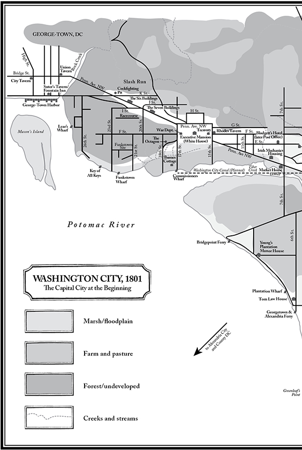
At the time, the western half of what we know today as the Mall didn’t yet exist. Instead, submerging the area was the sizable Tiber Creek, “a large sheet of water clear from Burnes’ old farm-house to the Seventh-street bridge above the market-house” where “a great many sycamore and other trees” grew and Hines often walked “in search of turtle nests.”3 Near the bridge “was a considerable swamp, overgrown with bushes, briars, thorns, &c. . . . At times, when the tides were high, the fish would come up the little stream as high as E street, especially the smaller kind, such as perch, smelts, eels &c.”4 The land was rich and verdant, thick with thorn bushes and grape vines, as well as hickory, oak and chestnut trees, making for “a complete little wilderness.”5
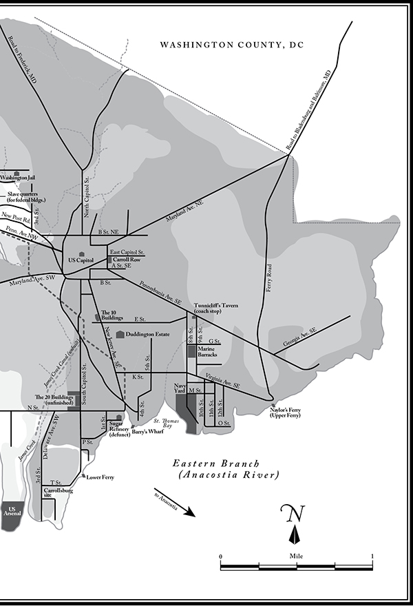
Not surprising for a place littered with swamps and marshes, the region was one of the most well-watered landscapes on the East Coast, featuring no fewer than thirty-eight individual springs,6 a convenient and accessible source of drinking water in the first half of the nineteenth century, much of it drawn by pumps and wells from the groundwater just below the surface. Some of the springs fed creeks of varying size. These included Rock Creek, cascading in from the north and forming the border between Georgetown and Washington City; its tributary, Slash Run, just east of it; and James Creek, leading from the Capitol south to the Eastern Branch near Greenleaf’s Point.7
The largest and most important creek, the Tiber, didn’t quite live up to the grandeur of its namesake, but at least it was a lot cleaner than its Roman counterpart. It began three and a half miles north of the Capitol, its main branch taking a westward turn near what became downtown—past the complete wilderness from Hines’s youth—then widening around 17th Street before dumping into the Potomac.8 Together, the Tiber and the tidal marshes near its mouth gave the appearance of a lake, stretching a thousand feet across, thronged with swans, ducks, and geese.9 (Tiber Creek was better and perhaps more accurately known as Goose Creek.) The creek and its marshlands formed the center of the city, which sat in a broad natural amphitheater surrounded by a series of river terraces with bluffs up to thirty feet high and peppered with countless bogs, ponds, and swamps.10Farther north lay an even steeper escarpment, where Boundary Avenue marked the curving northern edge of Washington City.11
Where the Tiber met the Potomac, along its northern bank, stood the so-called Key of All Keys, a huge rocky outcrop where British general Edward Braddock reputedly landed in 1755 during the French and Indian War, before enemy forces ambushed him at Fort Duquesne. A landmark of sorts, also known as Braddock’s Rock, it later became a quarry, and its stone helped form the foundations of the White House and Capitol until what remained of it was blasted away in the 1830s.12 (A fragment of it remains, hidden deep in a rocky shaft just off an approach ramp to Highway 50 and covered by several feet of groundwater.) Among General Braddock’s men was a lieutenant colonel named George Washington, whose subsequent acquaintance with this part of the Potomac in no small measure encouraged him to site the new American capital here thirty-five years later.
Washington’s Potomac Logic
Well before he became president, Washington had developed a theory on why the inland Potomac region would make an ideal spot for settlement. For one, the site lay at the nexus of future commerce, near the primary north-south coastal road along the eastern seaboard, yet it also could capture its share of maritime trade on Chesapeake Bay. It lay inland enough to have access to the American heartland, in the mountains and valleys of which lay deposits for mining, forests for lumber, and wheat and cattle for farming. The area had a great historical pedigree: Captain John Smith had explored this part of the bay in 1608, his party dining on venison and bear while trading with the Natives for beaver and otter skins. Smith remarked that the fish were “lying so thicke with their heads aboue the water, as for want of nets . . . we attempted to catch them with a frying pan.”13
Georgetown already had shown what opportunities the area offered, its deepwater port accommodating vessels for overseas trade, carrying a variety of goods from tobacco, leather, and candles to soap, flour, and beer, as well as river craft hauling shad and herring to neighboring colonies.14 Just down the river sat Alexandria, which dominated the Virginia trade in wheat, flour, and tobacco and boasted plantation manors owned by some of the biggest names in the Tidewater.15 However, above all this stood the most important geographic reason for the new capital to be sited here: the Fall Line.
At the Fall Line, the harder, erosion-resistant rocks of the Piedmont plateau meet the softer sediments of the Atlantic coastal plain. In the topography of the region, a series of waterfalls or rapids typically marks this boundary, of which Great Falls, with its “wild and romantic scenery,” is the most prominent near Washington.16 Most major East Coast cities sprang up along this line to give them access to the river-borne trade of the interior, as well as saltwater commerce overseas, and to use the water power to operate mills and other industrial enterprises.17 Washington City was no different. But navigating past the Fall Line presented challenges: Strong currents capsized boats and dumped commercial loads overboard, especially during floods, and in low water rocks and snags transformed rivers into obstacle courses.18 For practical purposes, the Fall Line marked the “head of navigation,” the farthest point upriver where boats could travel without locks or portage as well as the most inland reach of the tidewater. On the Potomac, the head of navigation lay at Little Falls, and the modest whitewater of these falls spilled out over the northwest border of the District.19For these reasons, Washington was sold on the river, thanking “the goodness of that Providence which has dealt its favors to us with so profuse a hand. Would to God we had the wisdom enough to improve them.”20
Improving on nature in this case meant building canals, which would breach the Fall Line and open the western interior as far as Cumberland, Maryland, and beyond—perhaps even to the Great Lakes. Washington saw it as a great opportunity for anyone “who wants land to cultivate [and] may repair thither and abound, as in the Land of Promise, with milk and honey: the ways are preparing, and the road will be made easy thro’ the channels of the Potomac.”21
To that end, in 1785 he became the first president of the Pawtomack Company, also known as the Potomack Canal Company, its stated goal to link the Tidewater region to the interior West. The plan first called for removing obstructions in the river and then constructing five canals to skirt the various falls that made upstream travel so difficult.22 With this auspicious beginning, the people of the nation would come together in common purpose as they developed the resources of the heartland, thereby building the country into a peerless commercial and industrial juggernaut.23
That was the theory, anyway.
The Trouble with Canals, Part One
George Washington was many things: skillful surveyor, stalwart general, supreme president. But a successful entrepreneur he wasn’t. His political skills and those of his fellow directors helped the company receive charters from the state legislatures of Maryland and Virginia in 1784 and 1785, respectively, and the initial capital seemed sufficient to start constructing the canals. But stockholders funded the Pawtomack Company on a pay-as-you-go basis, and this financing method proved disastrous when construction costs doubled and the original investors could pay no more. Faced with the prospect of their operation going under, the directors resorted to the desperate solution of lotteries to raise capital. When that didn’t raise enough money, the company went into debt to pay its bills and kept borrowing.24 In the end, the Pawtomack Company devolved into a financial disaster. By the time the tidewater states finally revoked its charter, it had lost half a million dollars.25
From an engineering standpoint, however, the company’s bypass canals were an amazing feat. Untrained builders with almost no formal technical knowledge constructed them, and they succeeded in allowing passage for rafts and keelboats through 218 upstream miles of the Potomac. Unfortunately, the canals took a long time to build—the last one, at Great Falls, was completed in 1802 after Washington’s death—and low water levels meant that they operated only for about six weeks of the year.26 Instead of shaping the Potomac into an essential commercial artery through the heart of America, the canals offered little more than a scenic curiosity. Their failure hardly dampened the desire of Washingtonians to develop the region’s resources, however, and that desire would only increase in coming decades.
Diamond on the Potomac
Washington’s insistence on squeezing Alexandria, Georgetown, and sites like Little Falls into the diamond-shaped boundary of the new federal district ensured that the enclave would be huge: one hundred square miles that needed roads, buildings, canals, wharves, and all manner of improvements. Encouraging citizens to relocate to the capital and building adequate housing and infrastructure for them posed an obvious challenge. But an even bigger question was the water—and what to do with all of it.
As with all of its early problems, the District had to look to its own sopping backyard for a solution. As historian Frederick Gutheim says, “the city was literally built out of the natural resources” of the region, from the timber and stone for its buildings and streets, to the marble for its monuments, to the canals cut from its creek beds.27 Those who worked the rivers had a head start on exploiting their potential. Shippers in Georgetown and Alexandria offered prices comparable to or even lower than the costs for transporting goods overland; the Navy Yard manufactured vessels and ordnance to defend the nation (albeit increasingly underfunded by the Jeffersonians); and an array of maritime facilities lined the Eastern Branch.28 The region’s fishermen made a good catch in shad, gar, eels, pike, sturgeon, perch, and smelt, with herring being especially abundant in the waters of the mid-Atlantic.29
Elsewhere, shipping facilities operated at Lear’s Wharf, Barry’s Wharf, and Commissioners Wharf, and riverside links connected Virginia to the Georgetown and Alexandria and Bridgepoint ferry landings (soon the site of the Long Bridge) and to the small settlements in Anacostia at the Upper and Lower Ferry sites.30 All that needed to happen was for the leaders of Washington, like those of Baltimore and other ports, to develop their city’s docks, yards, and other maritime infrastructure, thus giving the District a real commercial vigor and making it a valid threat to its Atlantic competitors.
But the city’s planners didn’t just envision an economically viable city. They wanted a place with grand aesthetic appeal and visual harmony, a majestic landscape to serve as a testament to republican strength and virtue and to rival any of the creaky old cities of Europe. So why not start the District’s rise to greatness with a bold stroke by channeling its waterways into beautiful fountains and canals, both functional and attractive?
Artful Designs
Pierre L’Enfant envisioned a magnificent canal in the French style flowing through the center of the capital. At Versailles, the Grand Canal and copious fountains not only offered visual delight but also drained the area’s lowlands. So too would those of the federal city, according to his plan. Tiber Creek would become a grand canal in the American style, and fountains would cascade forth from Jenkins Hill below the Capitol, in a colossal show of engineering skill and invention.31 The new canal would link the Potomac near old Funkstown (now Foggy Bottom), run between downtown and the Mall, take a great turn southward at the Capitol, and finally split into two branches terminating respectively near the mouth of James Creek and New Jersey Avenue SE.‡32
‡ Many early maps of the District depict both canal branches. However, the James Creek canal never existed at the same time as the New Jersey Avenue canal. It took seventy-five years for the former to be built, and then only after the latter had been converted into a sewer, making maps from the era more aspirational than factual.
The canal also would open nautical traffic, and thus trade and industry, between the Potomac and the Eastern Branch, conveniently passing the capital’s major civil and commercial centers along the way.33 George Washington quickly saw the benefits of L’Enfant’s vision, endorsing it in a letter to Jefferson in August 1791 as essential to the prosperity of the city.34 But the following February, Washington fired the prickly city surveyor, and in a huff L’Enfant took his capital plans with him.
The setback was serious but not insurmountable. Into L’Enfant’s place stepped Andrew Ellicott, and the map he created bore many of the hallmarks of L’Enfant’s baroque design, including the much-vaunted canal. A few twists and turns had changed, but in many respects it was the same waterway that the peevish Frenchman had designed.35 All the capital’s canal needed was capital.
At the time, private companies funded most urban improvement ventures, whether through pay-as-you-go investments or devices like lotteries. Usually with the blessing of a municipal or federal charter, such companies constructed bridges, turnpikes, and canals, their work overseen by a board of directors that included a host of prominent citizens. In the case of the Washington City Canal, one of them was a certain Mr. Law.
Tom Law, Canal Builder
When we last encountered him, Tom Law was wading neck deep into property speculation, letting James Greenleaf take him for a ride through the turbulent waters of Washington real estate. But along with property development, Tom Law had another great interest: public works projects. In 1796 the Maryland legislature authorized Law and Daniel Carroll to raise $52,000 for the creation of the Washington City Canal.36 In the District’s logrolling environment, it made sense: The two men obviously wanted to enhance the value of their property, and a lovely watercourse nearby wouldn’t hurt. They were banking on it, literally and figuratively, to provide a profitable link between their waterside lots in Southeast Washington and the riches of the Georgetown market.
Progress on raising capital for the canal had come slowly ever since it had appeared so tantalizingly on the maps of L’Enfant and Ellicott half a decade earlier. So Law and Carroll, along with a few other directors of the enterprise, opted for lotteries to provide investment capital. But they soon found it rough going, as the lotteries failed to provide significant funds.37 So they shelved the idea for several more years.
But Law didn’t give up. His speculative energies may have fizzled and his fortune may have vanished into the black hole of the Greenleaf syndicate, but he entered the nineteenth century more committed than ever to see his projects through. In 1802 Congress granted him and his partners—including two different Daniel Carrolls—a charter to dig the Washington City Canal as long as they could raise the money.38 Ever industrious, Law already had a plan to run packet boats between Tiber Creek and the Navy Yard as a means of transport to compete with hackney cabs.39 Two years later, he anonymously wrote a pamphlet claiming “the salubrity of the city will be benefited by the canal,” while adding the caveat that “few will be induced to become subscribers, unless it can be demonstrated by calculation, that it will yield an immediate and constantly increasing profit.”40 He should have listened to his own advice.
The Washington Canal Company failed to raise the funds by 1809, when the company’s charter ran out. Congress reauthorized the company the same year to seek out $100,000 for construction, and it held a groundbreaking ceremony the following year, digging a few trenches before running out of money again in 1812.41 Congress once more came to the company’s aid and declared that the old Maryland lotteries remained intact to raise capital, but these too failed. Two years later, during the War of 1812, the British invaded and burned down the capital.
By this point it should have become clear that it wasn’t easy or simple to fund a canal by private means in the early nineteenth century. The construction required too much labor and capital for the tastes of fickle pay-as-you-go investors or lottery-ticket buyers, and not enough well-heeled investors wanted to risk their fortunes on speculative building schemes—enough of those already existed on dry land. Civic leaders didn’t help matters either since they took more interest in envisioning grand plans than finding the practical means of executing them. But in the end it didn’t matter—the canal got built anyway.
With its reauthorization from Congress, the canal company was supposed to raise $100,000 in capital stock. However, according to Frederick May, the president of the company, it actually began “with permission to go into operation when 40,000 Dollars should be subscribed. Stock in the amount of 47,000 Dollars was taken and the work commenced.”42 It was a clever tactic, and it got work on the canal started. (It’s worth noting, however, that, in the letter from May to the secretary of the treasury, the original script says “without permission.” Someone later went back and struck through “out,” raising the question of whether initial work had ever actually—and legally—been authorized.)
The Trouble with Canals, Part Two
Thanks largely to the labor of Irish immigrants (about which more in chapter three) the canal had opened for business by the end of 1815.43 The November celebration commenced with proud Tom Law and the other company directors, along with prominent citizens and city council members, floating through it on a barge followed by the Marine Band in another boat.44 It was all very lively and inspiring, just as it had been five years earlier when work had begun, but the company’s financial state didn’t stand in much better shape than it had then, and the canal itself left much to be desired.
With a few wharves and bridges already in place, the canal accommodated some barges and rafts carrying firewood, food, stone, and, of course, whiskey.45 But most larger boats couldn’t travel on it because of a lack of drawbridges at critical downtown crossings at 12th and 14th Streets. Any boat that drew more than a foot or two of water wouldn’t make it either because the canal had been cut to a depth of just three feet. In a slightly ridiculous touch, builders even lined the canal with stone to accommodate the wash of steamboats somehow expected to crowd the waterway. It all added up to a sorry sight: “Business was lacking, but even if that had come, the canal was useless.”46
What made the canal worse than useless, though, were the tides. At high tide, water rushed in and inundated the canal, sending some boats out of control and grounding others along its banks. At low tide, hardly any water filled the middle section of the canal, which resembled little more than a muddy trench. No one had accounted for these fluctuations, and the situation worsened. By 1818 the channel was usable only at high tide because of the buildup of silt deposited by the river, and cargo had to be scowed in to the wharves downtown.47 (The silt resulted from the felling of area trees, which promoted erosion as the Potomac and Eastern Branch sent unrooted earth downriver, plugging up river channels as well as the outlets of the city canal.48) The canal’s center section soon turned stagnant, and garbage began to collect there.
Nevertheless, canal promoters, Tom Law among them, refused to consider their project a failure.49 If the canal could be deepened and improved, they argued, the District would have its economic lifeline in working order. That may have been true, but there wasn’t enough money in the canal company’s coffers to do anything about it. Maintenance and repair work were lacking, and the company had barely enough money to exist: as little as $5,402 in 1822 to cover its annual costs.50 Even though the federal government stood to gain from the success of the canal, it refused to help until the company effectively foundered and the canal had become a financial disaster.
That didn’t happen until 1831, but in the meantime came another, much more serious bout of canal fever.
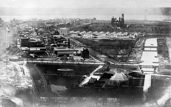
The stagnant city canal created a moat around Southwest Washington City, which became known as The Island.
Canal Fever
To most in the country, public works glory reached its pinnacle with the Erie Canal, “the greatest water resource project of the nineteenth century.”51 That legendary concourse of commerce connected New York City with the Great Lakes and gave it access to all the riches of America’s heartland and the Midwest. Completed in 1825, the Erie Canal helped New York usurp what should have been the glory of New Orleans and secure its place as the country’s greatest port, commercial entrepôt, financial capital, and population nexus. With good reason historians use the phrase “canal fever” to refer to the heady promise of the Erie Canal for many American cities, which then built other channels in its wake, a phenomenon that “almost reached the proportions of a mania.”52 Washington’s leaders gave into the fever as well—even as their earlier attempt at creating a municipal canal sat pungent and moldering under ever-deeper layers of mud and silt, a dirty open scar of civic failure that couldn’t be wished or washed away.
Perhaps not surprisingly, one of the promoters of the brand-new canal was Tom Law. While still a director of the failed city canal, Law put his remaining energy, at seventy years old, into the freshly devised Chesapeake and Ohio Canal. A member of the promotions committee for the canal, he had been working since 1823 to help create a new watercourse to unite the mid-Atlantic with the Midwest politically and commercially. Four years later, Law testified before Congress about the glories of the proposed channel, and a year after that, on the Fourth of July, toasted the alliance of “the River of Swans with la belle Riviere”—a fancy French way of saying that the Potomac would link up to the Ohio Valley and the growing city of Pittsburgh.53 It was the District’s last, best chance to develop a canal that worked.
The Next Wonder of the World
The Chesapeake and Ohio Canal still exists. You can visit this national historical park on a tour of Georgetown, enjoy a boat ride through some of its locks, hike along its banks, take pictures of its industrial technology, and try to imagine the picaresque days of canal men piloting their barges in view of the Potomac while mules did most of the work on the towpath. In fact, if you didn’t know better, you might never suspect that this 184.5-mile watercourse nearly ruined the city of Washington, plunged the region into a fiscal crisis, and caused the nineteenth-century federal government to take that rarest of actions—bailing out a failed corporation—all to prevent foreign creditors from calling in their debts and forcing the nation’s capital into bankruptcy and liquidation. Such are the ironies of the C&O Canal.
But at least the C&O wasn’t as ill-considered as its Washington City counterpart. The C&O did have a useful aim in paralleling the Potomac and getting around its obstructions, and the old Pawtomack Company’s assets and infrastructure transferred into the new enterprise too. Reaching the Monongahela River would give the region a lifeline into the agricultural and industrial riches of the Ohio Valley, and Washington City surely would make a reasonable outlet for that commerce (which, after all, couldn’t all go to New York City). Even better, the brilliant Benjamin Wright would serve as head engineer for the new canal, as he had for the Erie Canal. With business and public enthusiasm to spare and countless newspaper editorials hailing the inevitable greatness of the canal, the groundbreaking ceremony took place on Independence Day in 1828, with President John Quincy Adams himself holding the shovel. He proclaimed the C&O would be a “conquest over physical nature such as never yet been achieved by man. . . . The wonders of the ancient world, the Pyramids of Egypt, the Colossus of Rhodes, the Temple of Ephesus, the Mausoleum of Artemisia, the Wall of China, sink into significance before it.”54
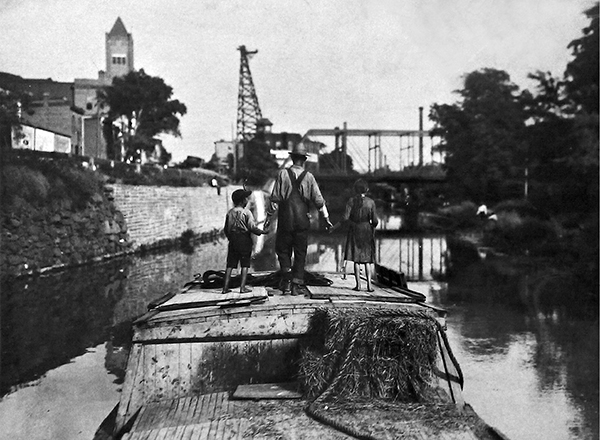
A leisurely boat ride along the Chesapeake and Ohio Canal in later years.
Inspired by his own hyperbole at the groundbreaking, President Adams plunged in his shovel—and immediately hit the root of a hickory tree (an ominous portent, since Old Hickory himself, Andrew Jackson, beat him in the November election). Taking off his jacket, President Adams hacked at it for a while until it gave way and the first chunk of soil could be cut from the earth.55 It was an obvious warning sign, but the problems had begun well before the president struck that pesky root.
The earliest red flag had been an 1826 report by the Army Board of Engineers that estimated the project to cost more than twenty-two million dollars, four times its original budget. After an outcry, another report deftly reduced the required sum to four million dollars, with the capital to be raised from corporate subscription. Lower Potomac cities would borrow money and raise taxes to pay the interest on their new public debt, which of course would be retired when the canal began paying dividends.56 The new report made another change: It halved the canal’s path, which now would run only to Cumberland, Maryland, stopping well short of the Monongahela River and making its name a misnomer. The C&O Canal had lost its “O” and arguably its reason for being. As you might expect, however, this twist didn’t halt work on the canal. Instead, canal fever raged.
In 1828 Congress passed a bill allowing municipalities in the District to triple their public debt to help fund the canal. Instead of public alarm or even debate ensuing, Washington’s mayor hoisted the flag, and a cannon sounded a peal of fiery joy.57 Business owners in Georgetown took note of the frenzy and dramatically raised the sale prices of their land and easements to allow the canal to pass through. Among them, Charles Carroll, like his relative Daniel, couldn’t resist a bit of speculation when he had the chance.58Everyone wanted to cash in.
Potomac Valley Blues
The area’s desperation for a link to the C&O stemmed from more than just canal fever, though. The District’s commercial and industrial development was languishing, banks were closing, and the mood was growing dire. Washington City’s mayor rued his town’s “almost total absence” of commerce, and even those in Georgetown took a bleak outlook: “Our town, notwithstanding its local and natural advantages for trade, has been gradually declining, our population is deminished; our houses untenanted; and the people earnestly pleading that the avenues of commerce may be opened.”59
Residents and leaders of the cities saw the waterway almost as a magical talisman, hoping and expecting it to bring them relief from their doldrums. Alexandria created an aqueduct that carried C&O barges across the Potomac from Georgetown and fed into a branch of the canal that traveled seven miles south before reaching the city. The cost ran to $1.25 million, an amount difficult to raise by private subscription, which meant that the Virginia channel took until 1843 to complete.60 Washington City, however, as the seat of federal power, had more clout than Alexandria. It just blackmailed Georgetown to get what it wanted.
Georgetown had the gall to propose terminating the C&O at Little Falls, well north of the capital city’s border. But Washington City’s trump card was simple: It too was an investor in the C&O, but it hadn’t yet paid its million-dollar subscription. Nor would it unless the canal’s directors approved a linkage to the Washington City Canal. Already short of funds, the C&O directors had no choice but to pay for an extension and locks to connect it to the city canal.61 But by then, in 1833, the bill for canal fever was coming due.
The Trouble with Canals, Part Three
The problems this time had started in 1831 when Washington City bought out the Washington City Canal Company for fifty thousand dollars and then contributed more money to widening the dysfunctional waterway, with the notion that such improvements would be needed for the linkup to the C&O.62 In reality, the buyout did little to stimulate commerce and only pulled the city further into debt, made worse by its capital contributions to getting the C&O finished and losses from lotteries to pay for the city canal. The debt level reached $1.7 million, which Washington City tried to offset by raising its municipal tax rate to the highest in the nation.63
It’s worth remembering that at this time most of Washington’s roads were unlit, unpaved, rutted, and dangerous. Garbage lined the streets, and feral hogs scavenged the filth.64 Pockets of unfinished, derelict houses gave the place the look of a village instead of a city. In short, the place was commercially and industrially stunted. Yet despite such a clear need for major civic improvements, the city’s leaders funneled money foolishly and profligately into the canal business and made the town suffer for it. As Senator Samuel Southard, chairman of a committee overseeing the District, put it: The city had such colossal debt that “it is utterly impossible that it can be relieved by any means within its own control” and “it will very probably in a short time be driven to the surrender of its charter”65—meaning an abrupt end to Washington City itself.
In their zeal to find funding, the District’s cities had borrowed lustily from bankers overseas, in this case from Holland, long a favored source of foreign investment. Now that the debt was maturing and the cities scarcely could pay the interest, let alone the principal, panic bloomed. Southard saw, at a minimum, that bankers would “become the owners of a great proportion of the property within the capital of the Union” and other politicians worried that “the agents of the foreign creditors are here ready to purchase the property of these citizens of Washington [the canal shareholders] under the hammer, so that there is danger emphatically that this city may be sold to the Dutch.”66 It wasn’t an empty threat, either. As one observer wrote, “it may be safely affirmed, that unless Congress pays the debt . . . the whole city of Washington must soon be for sale, and be the property of the Dutch bankers.”67 Indeed, the foreign investors had already arrived in the District and stood at the ready to get their money back by laying claim to the collateral.68
Facing the absurd possibility of the capital of American democracy legally falling into the hands of Europeans, Congress finally stepped in and paid $1.5 million to settle the cities’ debts in exchange for control of their canal stock.69 In 1836 the nation thereby took ownership of the watery white elephants created by the cities of the District of Columbia. It wasn’t much of a bargain for the federal government.
The Alexandria and Washington City Canals never lived up to their promise, and the C&O Canal took another fourteen years to complete. While that canal did prove useful during the Civil War for ferrying troops into Maryland and for hauling great loads of coal downstream from Cumberland, this $11 million watercourse for the most part failed to deliver on its promise and became increasingly antiquated as the years passed.70
As a telling coincidence, ground broke on the C&O Canal and the Baltimore and Ohio (B&O) Railroad on the same day, July 4, 1828.71 But the rail line struck much more successfully into the heart of the Midwest, often paralleling the canal itself and reaching Cumberland in 1842, eight full years before the canal did. The railroad even extended a branch to Washington City in 1835 (though Congress perversely forbade steam engines from entering the capital itself for another seventeen years), ending the stagecoach monopoly over land transit and halving the travel time between Baltimore and Washington City.72 Even more than the railroad, the Panic of 1837 delivered the ultimate cure for canal fever, thrusting America into a six-year economic tailspin and scuttling most of the major waterway projects not already under way.
The battle for American transportation supremacy had ended, and canals had lost.
The Pride of Waters
Natural waterways continued to fare better than their man-made counterparts. Lined with facilities for making or storing beer, guns, rope, sugar, and tobacco, the Eastern Branch hummed with activity.73 On that river, the Navy Yard wasn’t just the local military powerhouse, it also offered one of the few bright spots in the District for manufacturing, its forges and furnaces churning out everything from anchors and anvils to copper nails and lead pumps.74 Around the Navy Yard, a thriving working-class neighborhood developed. To the west, the Potomac River continued its profitable commerce in bar iron, flour, grain, sugar, timber, and whiskey,75 providing an economic pulse to the struggling cities of the District and showing how much more valuable the workaday river trade was to the capital than the chimera of canal trade. Area rivers boasted some 150 fisheries that hauled in so much fish—including 400,000 barrels of herring, according to one report—that the surplus catch was used for fertilizer.76
In the end, the rivers greatly advantaged the District, and the tidewater served as an essential economic outlet. But civic planners continued to look the wrong way with their ill-fated schemes to reach the interior of the country by channeling upriver and forcibly imposing an urban waterscape on a region that naturally resisted it.
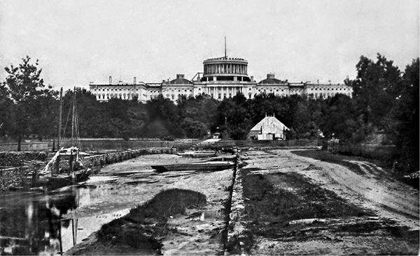
In the shadow of a domeless Capitol, the dismal Washington City Canal flows through the Mall in 1860.
Arcadia Lost
In his reminiscences, Christian Hines focused on the years of his youth, around 1800, with good reason. Shortly after that, the city slowly emerged, and his little wilderness began to disappear. The old streams that once funneled freshwater through the terraces vanished first, replaced by drains and culverts starting in 1810. Some thirty years later, spring and well water began to flow into private residences, and sewage was pumped out and into those same drains and culverts. By the eve of the Civil War, most waterborne waste poured directly into the rivers.77 Washington City accordingly became as dirty as any other city, its freshwater springs and wells increasingly polluted or drying up.78 Even the grounds south of the White House transformed into a filthy marsh choked with sewage and wastewater from urban runoff.79
But worst of all, the “Great Tiber Freshet” became the Washington City Canal. While its northern reach fed into a system of drains and culverts, the part running along downtown was channeled, graded, walled, and streamlined to become the city’s most notorious public works disaster. Unlike the C&O Canal—which functioned to some extent—the city canal posed an active and worsening public health threat. Even in the mid-nineteenth century, it served as an ongoing and unavoidable reminder of the poor decisions and political ineptitude that had marked the District from the moment it became the capital.