
· · · OHIO, INDIANA, ILLINOIS, MICHIGAN, WISCONSIN · · ·
With respect to the new States, were the question to stand simply in this form: How may the ultramontane territory [the land west of the Appalachians] be disposed of so as to produce the greatest and most immediate benefit to the inhabitants of the maritime States of the Union?—the plan would be … laying it off into two or more states only.… Good faith … requires us to state the question in its just form: How may the territories of the Union be disposed of so as to produce the greatest degree of happiness to their inhabitants?
—THOMAS JEFFERSON1
Whether or not the Founding Fathers truly shared a common vision, there is no question that Thomas Jefferson possessed and expressed a vision that gazed far into the nation’s future. And while many of his views are difficult to pin down, his views regarding the American map were crystal clear.2 Yet, looking at what that map has become, the United States appears to have closed its eyes to his vision. Or is it that his influence can be difficult to detect?
One example of Jefferson’s mercurial legacy is the eastern border of Iowa. He was responsible for establishing what is today the eastern border of Iowa, yet not responsible for the same border of its neighboring state, Illinois. The border separating Iowa and Illinois is the Mississippi River. It was the eastern boundary of the Louisiana Purchase, which was completed by Jefferson as president in 1803. Subsequently the river became the eastern border of present-day Iowa, Missouri, Arkansas, and segments of Minnesota and Louisiana. Since the Mississippi had been the western boundary of the United States prior to the Louisiana Purchase, it was already in place as the western border of present-day Illinois, Kentucky, Tennessee, and segments of Wisconsin and Mississippi.
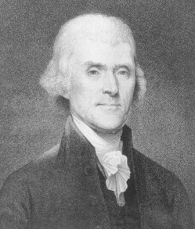
Thomas Jefferson (1743-1826) (photo credit 9.1)

Louisiana Purchase: boundary uncertainties
Other than those states with eastern borders on the Mississippi River, no other state has a boundary reflecting Jefferson’s historic purchase. The Louisiana Purchase is now all but invisible on the map because of the language in Jefferson’s treaty with France conveying the land to the United States. It declared that, after Spain officially ceded the land back to France, France would sell to the United States “the Colony or Province of Louisiana with the same extent that it now has in the hand of Spain, and that it had when France possessed it.” Compared to today’s government documents, the treaty, running less than 1,500 words, was extraordinarily brief and clear. On the other hand, it lacked certain details—such as the precise boundaries of the land it conveyed. This was because Jefferson knew that Spain (and England) disagreed with France as to the extent of the province of Louisiana. But Jefferson also knew that Napoleon’s offer wouldn’t last long, so he accepted it without quibbling over that detail.
Though the Louisiana Purchase is Jefferson’s most famous geographic contribution to the United States, back in his days as Virginia’s representative to the Continental Congress, he made other important contributions that, by contrast, provided highly specific details of his vision for the future of the United States. Today, however, only the ghosts of that vision inhabit the lines on the American map. Their geodetic life ended when Congress began tinkering with Jefferson’s vision.
While in the Continental Congress, Jefferson chaired a committee that had been created to prepare a plan for the temporary government of the western territory of the United States. At the time, the nation’s western territory consisted of the land acquired in 1763 by England and the American colonists in the French and Indian War (the Northwest Territory) and all the other land west of the Appalachian Mountains. Prior to the Revolution, this second area of land had belonged to a number of the colonies. After the onset of the Revolution, these colonies—now states—eventually, if not happily, ceded their western regions to the federal government to create additional, more equally sized states.
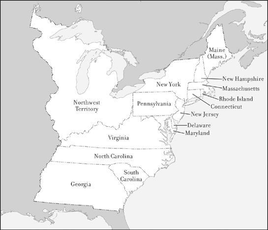
United States, 1784
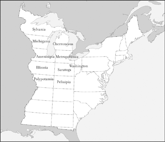
Jefferson’s 1784 proposal for new states
Jefferson’s committee reported back to Congress in March 1784. It proposed boundaries for the future states to be created in the western lands, the process by which they would become states, how these areas would be governed prior to becoming states, and even names for most of the proposed states. While the report was issued by a committee, considerable evidence suggests that the states it proposed reflected the vision of Jefferson.3
The boundaries of these states and even their names tell us a good deal about this particular Founding Father. The names he assigned included Sylvania, Michigania, Cherronesus, Assenisipia, Metropotamia, Illinoia, Polypotamia, and Pelisipia—all neoclassical constructions hearkening back to the ancient democracies of Greece and Rome. The two remaining names, Saratoga and Washington, memorialized the American Revolution. In addition, while the monarchs of England often named American colonies after individuals, Jefferson named only one of his proposed states after an individual—an ethos that continued long after Jefferson. In the years ahead, Congress would reject Tennessee’s originally proposed name (Franklin) and Colorado’s first proposed name (Jefferson). Most senators and representatives viewed only one American as worthy of having a state named after him, that person being George Washington. Other than Washington, however, none of Jefferson’s proposed names was ever used, although Illinoia and Michigania, once declassicized, did become state names.
Similarly, Jefferson’s proposed boundaries were also scrapped between then and now. But the principle underlying his boundaries is all over the map. Jefferson’s underlying tenet was that all states should be created equal, or—characteristically applying pragmatism to his ideals—as equal as possible. Jefferson’s report stated:
The territory ceded or to be ceded by individual states to the United States … shall be formed into distinct states bounded in the following manner, as nearly as such cessions will admit, that is to say: northwardly & southwardly by parallels of latitude so that each state shall comprehend from south to north two degrees of latitude.
Still, as can be seen from the map of his proposed states, Jefferson did not consider size to be the sole factor in determining equality; he also considered geographic and agricultural factors. Consequently, the widths he proposed varied slightly:
Eastwardly and westwardly they shall be bounded, those on the Mississippi by that river on one side and the meridian of the lowest point of the rapids of Ohio on the other; and those adjoining on the east by the same meridian on their western side and on their eastern by the meridian of the western cape of the mouth of the Great Kanhaway [the present-day Kanawha River].
In effect, Jefferson proposed two tiers of states with slightly different dimensions to mitigate differences in resources. While his lines do not appear on the American map, their prototypical dimensions do. Indeed, two tiers of states ultimately did emerge, side by side, further west: Kansas, Nebraska, South Dakota, and North Dakota all have three degrees of height. Neighboring them, the mountainous states of Colorado, Wyoming, and Montana all have four degrees of height. Wyoming, Colorado, North Dakota, and South Dakota all have seven degrees of width, as do (allowing for coastal wiggles) Oregon and Washington.
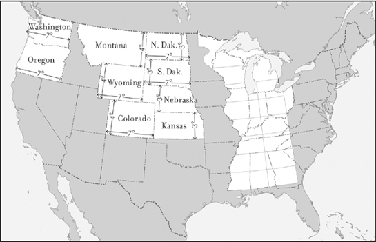
Ghosts of Jefferson: prototype shapes
When did Congress begin fiddling with this Founding Father’s vision? Answer: eighteen days after his report. The report was delivered to Congress on March 1, 1784, and on March 19 Congress began altering it. Three days later, Jefferson presented additional revisions, to which additional amendments were made the following month. But the largest change came in 1787, when Congress enacted the Northwest Ordinance. Jefferson’s proposed state names were now gone and, with the Northwest Ordinance, his proposed boundaries were also swept under the carpet. Moreover, the new proposed state borders were now confined solely to the Northwest Territory.
By then Jefferson himself was no longer in Congress; in fact, he was no longer in the country. He was in Paris, serving as the American ambassador to France. But he was not happy with what Congress was doing to his plan. The Northwest Ordinance stipulated that the region would be divided into “not less than three nor more than five States.” It then described where those divisions were located. These new boundaries were largely the work of Jefferson’s fellow Virginian (and fellow future president) James Monroe. Jefferson wrote to Monroe, his friend and protégé:
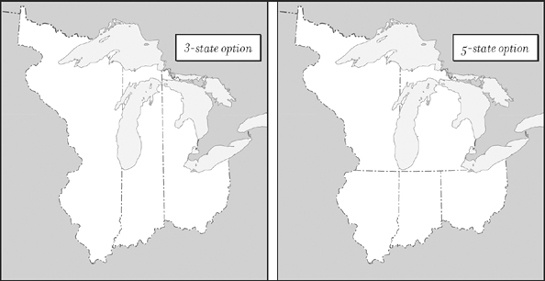
Borders stipulated in Northwest Ordinance of 1787
Will their inhabitants be happiest divided into states of 30,000 square miles, not quite as large as Pennsylvania, or into states of 160,000 square miles?… They will not only be happier in states of a moderate size, but it is the only way in which they can exist as a regular society. Considering the American character in general … a state of such extent as 160,000 square miles would soon crumble into little ones … and if they decide to divide themselves, we are not able to restrain them. They will end up by separating from our confederacy and becoming its enemies.4
Indeed, 160,000 square miles is the approximate size of the westernmost state proposed in the Northwest Ordinance, composed of present-day Illinois, Wisconsin, and regions of Minnesota and Michigan. Had such a state ultimately been created, it would be roughly the size of California.
As can be seen on today’s map, Congress eventually divided the Northwest Territory into five states. It also relocated numerous borders stipulated in the Northwest Ordinance. Nevertheless, each of the states that finally emerged exceeds 30,000 square miles.
Knowing when Congress tinkered with Jefferson’s vision begs the more important question: why? The congressional resolution that ultimately altered Jefferson’s boundaries stated that increased knowledge of the regions involved revealed that some of the proposed states would be deprived of navigation and others would consist almost entirely of barren mountain land. Indeed, this was true, but it wasn’t the whole truth. The rest of the story wasn’t openly revealed in Congress until 1845, during the debate over Iowa’s statehood. Arguing for a return to more Jeffersonian boundaries, Ohio Congressman Samuel F. Vinton explained how the result of Jefferson’s proposed borders
would have been ultimately to give the country beyond the mountains a majority of the States.… Shortly after the conclusion of the war with England [the Revolution], very serious difficulties arose between Spain and the United States respecting navigation of the Mississippi. Our settlers in Kentucky and Tennessee … looked to the Mississippi and its outlet through the Gulf of Mexico as their early road to market.… An opinion seems to have sprung up in the Atlantic States that the interests of the transmontane country would always be adverse to theirs.
That earlier Congress did indeed have cause for concern. The residents of North Carolina’s land west of the Appalachians (present-day Tennessee) had grown impatient at the delays preventing it from becoming a separate state, and in 1784 they declared themselves the state of Franklin. Many of its residents further agitated for the state of Franklin to declare itself an independent republic and commence negotiations with Spain.5 This risk not only spurred Congress to begin at once creating states in the land west of the Appalachians, but also to create larger and therefore fewer states than Jefferson had recommended. Fewer states in the region, Vinton went on to point out, would translate into fewer votes in the Senate. And treaties could be ratified only by the Senate.
One other of Jefferson’s proposals, however, did survive the crucible of democracy. At the same time that he was proposing the division of the nation’s western lands into future states, Jefferson offered a separate proposal stipulating the method by which the boundaries of and within these western lands would be located. “It shall be divided into Hundreds of ten geographical miles square … by lines to be run and marked due North and South, and others crossing these at right angles,” he urged. “These Hundreds shall be subdivided into lots of one mile square each … marked by lines running in like manner due North and South, and other crossing these at right angles.”6 Jefferson, whose many accomplishments including surveying, did not invent this approach. It was already known as the rectangular survey system, one of several methods used by surveyors at that time.
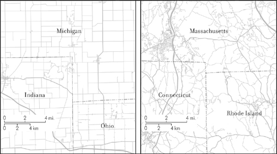
East Coast roads and Midwest roads
Today airline passengers flying over the eastern states and the Midwest can look down and see a clear change in the pattern of the roads. East of the Appalachians, the roads generally conform to geographic features. In the Midwest, where the Northwest Ordinance was implemented using the method proposed by Jefferson, they conform primarily to a right-angled grid, positioned north–south by east–west. While Jefferson’s influence on the American map can be difficult to detect, in that grid of roadways we can see his literal imprint on the United States.