
· · · CALIFORNIA, OREGON, NEVADA, IDAHO, UTAH · · ·
The Spaniards have seized three British vessels in the fur trade at … Nootka Sound, on the western coast of North America.… Their crews are sent to Mexico in irons.… [The incident] has been transmitted and presented to the government by a Mr. Meares, who came home a passenger.
—LONDON CHRONICLE, MAY 1, 1790
Amultistate boundary line separating the southern ends of Oregon and Idaho from the northern ends of California, Nevada, and much of Utah owes its existence to both Spanish Canada and China. Canada is not typically thought of as Spanish, nor are American state lines usually connected to Chinese influence. But a glance at a map of Canada’s Vancouver Island reveals remnants of Spanish Canada in names such as the Juan de Fuca Strait, Flores Island, Cortes Island, and Estevan Point.
Spain, as the first European nation to plant its flag in the New World, proclaimed that it owned it all. And from 1492 into the early 1600s, it did. But then other nations began infiltrating uninhabited coves and bays along the New World’s Atlantic coast and Caribbean islands. By the late 1700s, foreign infiltration also began on the western coast, as China became more open to European trade. One of the most valuable exports to China was the lustrous fur of the sea otter. Enter the adventurous English sea merchant, John Meares.
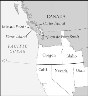
Line and remnants of Spanish Canada

John Meares (ca. 1756-1809) (photo credit 10.1)
From obscure origins, Meares struggled his way up the ropes of British seafaring to its top knots. Born in the mid-1750s in or near the town of Bath, he joined the Royal Navy at fifteen as a cabin boy. By the end of the American Revolution, he had shown enough intelligence and skill to rise to the rank of lieutenant. With the war’s end, however, his service was no longer needed. Meares needed to find a new avenue to wealth and fame. Quite possibly he found it by reading the newspapers. “The importance of Botany Bay will appear by all who examine Capt. Cook’s chart of his discoveries,” London’s Evening Post wrote in 1786. “Its situation is well adapted for carrying on a trade between Nootka Sound and Cook’s River on the American coast, and the islands of Japan and the Chinese Empire, in sea otter skins.” Botany Bay (present-day Sydney, Australia) was but one of British naval captain James Cook’s discoveries in the Pacific Ocean. In 1778 he discovered a way station for ships crossing that vast ocean en route to North America. The way station was a chain of tiny islands now known as Hawaii. It too would figure into Meares’s plans.
England was not the only nation reaping the riches of lands newly discovered by Europeans. All of Europe, joined now by the fledgling United States, elbowed for opportunities. But Spain remained the best positioned, having been the first to establish settlements and naval forces in these regions. Evidence of Spain’s power even permeated the previously cited news item, when it referred to the importance of Cook’s River and Nootka Sound on the American West Coast but made no mention of San Francisco, Los Angeles, or San Diego. Those better-known locations were controlled by Spain. (Seattle was yet to be discovered by Europeans.)
Though Spain had lain claim to all the Americas, and its explorers had ventured throughout the Pacific Northwest, identifying their claims by the Spanish names they gave them, it had not sought to settle the northernmost regions. History might have been different indeed had Spain learned there was gold in the Yukon and Alaska. As it was, Spain saw little profit to be reaped from the region and great expense in protecting it, since it was some 600 miles from its nearest available naval harbor at San Francisco.
On the other hand, Spain was well aware of profits to be had from trade with China. Early on it had established a Pacific base for such commerce by colonizing the Philippines. Spain was also well aware when China became an open market for sea otter furs, and it acted immediately to stop other nations from establishing trading posts along the coast of the sea otter’s habitat in the Pacific Northwest.
Into these waters John Meares set sail from Calcutta in 1786 on the first of his two voyages to the Northwest. His plan was to establish a permanent trading post for sea otter furs, which he would trade in China for goods to be sold in England. Meares was a raw newcomer, never having headed a commercial enterprise, nor commanded a ship. His apparent self-confidence, coupled with an independent streak, is revealed by the fact that neither of his two voyages was licensed by the East India Company—a risky move on his part. Just as Spain had sought to monopolize its discovery of the New World, so too did the British East India Company seek to monopolize its markets by prohibiting other Englishmen from engaging in trade with its markets.
For his first voyage, Meares arranged financial backing to secure two ships, which he named the Nootka and the Sea Otter. With himself in command of the Nootka, and a fellow navy lieutenant, William Tipping, commanding the Sea Otter, the two ships left India in March, 1786. Tipping’s Sea Otter, carrying opium, sold its cargo in Southeast Asia before setting a course for the Northwest. There the two ships were to rendezvous, if they had not met up already.1
Meares arrived at Cook’s River, in present-day Alaska, in August. He began trading with the natives for furs and learned that Tipping’s Sea Otter was just ahead of him. Meares followed in its direction, continuing to trade along the way. As winter weather approached, Meares had yet to acquire a full cargo. He had three choices. He could depart for China (as the Sea Otter apparently had done) but with fewer furs than he wanted. He could harbor for the winter in Alaska and resume trading when warmer weather returned. Or he could winter at the way station discovered and described by Captain Cook: Hawaii.
Meares feared that his crew would never leave the tropical paradise described by Cook, and he also feared the financial consequences of returning with inadequate cargo. What he didn’t fear was the Alaskan winter … because he had no clue of what it was. Few if any Europeans did. Just how bad did an Alaskan winter turn out to be? Newsworthy bad. “The Nootka … arrived at Oonalaska the beginning of August and arrived in Prince William’s Sound the end of September,” the London World reported in October 1787. “By the severity of the winter they lost their 3rd and 4th Mates, Surgeon, Boatswain, Carpenter, and Cooper and twelve of the foremast men; and the remainder were so enfeebled as to be under the necessity of applying to the Commanders of the King George and Queen Charlotte, who just at this time arrived.”
The rescue of Meares and his crew by the King George and Queen Charlotte was not particularly cordial. Both ships were licensed by the East India Company. From their point of view, Meares and his men were poaching. Their captains demanded that Meares pledge a £1,000 bond against his promise not to engage in any trade en route back to India, and that he turn over the metal and beads he was using to trade with the natives. In return, they provided Meares and his men with the bare necessities.
The news of Meares’s rescue was followed a week later by news of his venture’s sister ship. A brief item in the London World reported, “The Sea Otter, Capt. Tipping, sailed from Calcutta a few days after the Nootka … and arrived in Prince William’s Sound in September.… She left the Sound the day after, supposed for Cook’s River … but having never since been seen or heard of, there can be little doubt of her being lost.”
Once rescued, Meares and his crew set sail for Hawaii, where they replenished themselves and then went on to Macau, a Portuguese colony on the coast of China. Meares sold what cargo he had and his badly damaged ship, then immediately started in again. In less than two months, he had arranged financing for two other ships. To protect himself from the East India Company, he contracted to sail from Guangzhou (Canton), China, for a Portuguese merchant, enabling his ships to fly Portugal’s flag. Meares also protected his men against winter on this second voyage—and commenced his larger plan—by having his crew construct a permanent trading post in Nootka Sound. The one thing Meares was not protected against was Spain, whose ships soon entered Nootka Sound, where they too were arriving to establish a fur trade with China.
Meares himself had already departed with his newly acquired cargo, leaving behind a staff of Chinese craftsmen and seamen who, in addition to having constructed the trading post, had also constructed a ship, the North West America, as the next step in the expansion of Meares’s enterprise. It was to sail under the command of one of the few Englishmen left to oversee operations at Nootka. Because of the presence of these Englishmen, the arriving Spaniards needed neither hounds nor accountants to sniff out British control of these Chinese settlers working for a Portuguese merchant. What happened next, Meares later reported to Parliament, was that “on the 9th of June, [the North West America] was boarded and seized by boats manned and equipped for war, commanded by Don [Esteban José] Martinez, that he did … take possession of her in the name of his Catholic Majesty.… that the commander of the N. W. America, his officers and men, were accordingly made prisoners … and some of her men were … afterwards put in irons.”2
Public response in England to Meares’s carefully worded report was one of outrage. “The Court of Spain cannot be so devoid of understanding as to make a serious quarrel with this country upon so idle and ill-founded a pretence as her hitherto unheard of claim to the sovereignty of the seas to the northwestward of America,” London’s Woodfall’s Register exclaimed in 1790. “The Court of Madrid might, with as much reason, lay claim to the clouds, the stars, and the hemisphere.”
Not unlike today, the clamor was quickly exploited. Within a month, London’s Covent Garden Theatre had presented a topical play entitled Nootka Sound, or England Prepared. British militants accused Spain of creating a crisis to divert its people’s attention from democratic movements in other nations. In response, British peace advocates reminded their fellow citizens about the profitless war with Spain that had resulted from Robert Jenkins’s dubious account of a Spaniard lopping off his ear.3 (See “Robert Jenkins’s Ear” earlier in this book.)
Ultimately, England and Spain did not go to war. Instead, they signed an accord known as the Nootka Convention, which would later affect the locations of California, Nevada, and Utah’s borders with Oregon and Idaho. Under the Nootka Convention, Spain accepted the principle that a nation could not claim possession of land simply by having discovered it; rather, a nation must have established a permanent settlement on the land.
Nearly thirty years later, Secretary of State John Quincy Adams invoked the Nootka Convention in negotiations with Spain regarding the western boundaries of the Louisiana Purchase. By that time, an American settlement had been established at the mouth of the Columbia River in present-day Oregon. Adams cited that settlement as the basis for a border with Spain’s California settlements.4 Spain did not challenge Adams’s logic, though its representative quibbled with the boundary he proposed. Adams noted in his diary, “I showed him … the line offered in my note, upon which he only remarked that we might have taken the Columbia River from its source to its mouth, instead of the forty-first parallel of latitude.” In the 1819 Adams-Onis treaty that resulted, the boundary was fixed at the 42nd parallel. North of this parallel, virtually all the waterways flow to the Columbia River; south of it, virtually all flow to what was then Spain’s settlement at San Francisco.
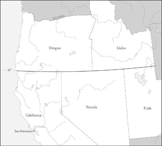
42°: the watershed line
But England also invoked the Nootka Convention, claiming its right to possess Oregon, based on British settlements along the Columbia River and the waterways leading to it. Having just concluded the War of 1812, neither the United States nor England wanted to renew hostilities, so the two nations agreed jointly to hold Oregon, which at the time extended to Alaska. This joint occupancy lasted some twenty-five years, at which point an American rallying cry for the region—“Fifty-Four Forty or Fight!”—once again brought the United States and England to the brink of war during the presidency of James Polk.
As for John Meares, he went on to undertake what many in his situation would do today: he wrote a book.5 His adventures on the frozen seas with enemies from Spain and bullies from the British East India Company, combined with the tropical splendors of natives in Hawaii and the mysteries of Canton, made the book a longtime favorite of many readers. One dissatisfied reader, however, was George Dixon, who had captained one of the East India Company ships that had rescued Meares. Dixon took offense at being depicted as an extortionist. So he wrote a book, too:
This Day is published, price 3s.6d
Further Remarks on the Voyages of John Meares, Esq.
in which several important facts, misrepresented in the voyages, relative to geography and commerce, are fully substantiated. Likewise is inserted a letter from Captain DUNCAN containing a decisive refutation of several unfounded assertions of Mr. MEARES, and finally a reply to his answer.
By Captain GEORGE DIXON6
Meares, meanwhile, returned to active duty in the navy, where he was promoted to commander and with it received a substantial salary. George III proclaimed him a baronet, enabling him to be Sir John Meares. With his military rank, a hereditary title, and his book still being issued and advertised, Meares returned to his hometown of Bath in 1796 and got married. He had achieved all he sought.
With his success, Meares disappeared from the public stage. His death in 1809 went unremarked by any known obituary. Still, his name remains engraved on the map in Meares Island, British Columbia, and Cape Meares, Oregon.