
· · · NORTH CAROLINA, GEORGIA · · ·
Raise as many Militia of your Battalion as you shall think necessary and pursue [the Georgians] from place to place … until you have taken their Leaders, if possible, and show them that we have law sufficient to suppress unruly Citizens.
—LT. COL. WILLIAM WHITSON, NORTH CAROLINA STATE MILITIA,
TO MAJ. JAMES BRITTAIN, DECEMBER 17, 18101
Had it not been for the actions of James Brittain, the boundary between North Carolina and Georgia might well be twelve miles north of where it is today. Until recently, however, one would be hard-pressed to find any history book that mentioned Brittain. The reason his name has now resurfaced is the flip side of the reason it was suppressed: convenience/inconvenience.2 Brittain’s story is an important part of North Carolina and Georgia history, but it has become more important for what it reveals about history itself.
James Brittain was born in the mid-1700s, served in the American Revolution, and afterward settled in Mills River, North Carolina, with his wife and children. The various surviving documents in which his name appears suggest he was a leading citizen in the region, though never its preeminent leader. He represented Buncombe County in the North Carolina Senate for six (nonconsecutive) terms.
He was not always an illustrious leader, as a 1792 resolution suggests:
The commissioners appointed to fix the center and agree where the public buildings in the County of Buncombe should be erected have failed to comply with the above recited Act, and the inhabitants of said county much injured thereby.… For remedy … Joshua Inglish, Archibald Neill, James Wilson, Augustin Shotes, George Baker and John Dillard … [shall] be appointed commissioners in the room and stead of Philip Hoodenpile, William Britain, William Whitson, James Brittain and Lemuel Clayton.3
Ten years later, Brittain’s name crops up in another snafu over public buildings, as revealed in an 1802 directive issued by the Buncombe County Grand Jury:
The Court house and Jail, the former of which being 35 feet long, stands partly on the Town street, and partly on the lot of Samuel Chunn and Zebulon Baird, and the latter on the lots of James Brittain and Andrew Erwin, so that the County, after expending a very considerable sum of money in executing said Buildings, have not the slightest title to the ground on which they stand …
(Signed) William Whitson, Foreman4
Brittain subsequently appears to have opted to donate the land inadvertently used to build the county jail, unlike others on the list.
Brittain’s personal finances were considerably more involved in his state’s boundary dispute with Georgia. In 1802 he purchased 100 acres of land, and in 1806 an additional 200 acres, elsewhere in Buncombe County, North Carolina—or, from Georgia’s point of view, in Walton County, Georgia.
Technically, this land had originally belonged to South Carolina. But South Carolina had ceded the region to the United States in 1787. At the time, it was within the domain of the Cherokee nation. In 1798 the government “negotiated” a treaty with the Cherokees that required them to relocate to a reservation west of the Mississippi River—a forced migration now known as the Trail of Tears. In the absence of the Cherokees, the land South Carolina had ceded to the United States remained outside any state’s jurisdiction. It came to be called the Orphan Strip.
The difficult access in the mountainous Orphan Strip provided ideal terrain for people who didn’t want to be found. So many such people repaired to the region that, in 1800, a congressional committee proposed that it be given to South Carolina.
South Carolina, however, passed on the offer. It had no interest in extending its jurisdiction into this labyrinth of mountains, where many residents had repaired to escape jurisdiction.5 North Carolina and Georgia weren’t interested either. But in 1802 the federal government found a new solution. Georgia (which then still included present-day Alabama and Mississippi) had gotten in hot water regarding land fraud in its western region. The federal government offered Georgia a deal. In return for relinquishing the land that would become Alabama and Mississippi, the United States would let Georgia off the hook for land fraud if it also agreed to accept jurisdiction over the Orphan Strip.
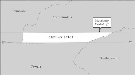
The Orphan Strip
North Carolina did not protest this offer, though some North Carolinians suspected that the state’s border with Georgia had been inaccurately surveyed. The border was stipulated as being a line along the 35th parallel. As it turned out, the 35th parallel is twelve miles south of where the border had been located.
Still, the United States had rid itself of a pesky problem, and Georgia dutifully organized the land as Walton County (not to be confused with present-day Walton County, Georgia). Georgia went on to appoint officials to govern its new county. What had been a notorious no-man’s-land was looking better and better … to North Carolina. That state now declared that the land was part of its Buncombe County. North Carolina likewise appointed officials to enforce state laws and register land titles.
Among those buying land and having the title recorded in North Carolina was James Brittain. Such purchases by absentee investors were precisely what most fueled Georgia’s ire. Often the investors sought to charge rent to those living on their land titled in Buncombe County, North Carolina. This did not sit well with those living on the land who held title to it in Walton County, Georgia. In some instances the North Carolina owners turned to the region’s North Carolina authorities to evict those who refused to pay their rent. Those Georgians living on such land who held title to it in Georgia turned to the region’s Georgia authorities for protection. Confrontations, often violent, ensued.
In December 1804 one such confrontation involved Buncombe County constable John Havner and several Walton County residents. It ended when Havner was struck in the face with the butt of a rifle, an injury that proved fatal.6 In response, North Carolina sent a unit from its state militia, under the command of Brittain. Walton County residents quickly massed to defend themselves. In Georgia the Augusta Chronicle reported the following in February 1805:
On the 19th of December, a party of horsemen consisting of 70 or 80 men, and headed by a Major James Brittain, marched into [Walton] County from Buncombe, North Carolina.… They took and made prisoners of Richard Williamson, James Lafoy, J. Cloud, G. Williamson, esquires, and several others.… Five they discharged and ten were kept and marched off like prisoners of war to Morganton, North Carolina.
Brittain’s foray resulted in the battle of McGaha Branch, where his forces quickly overtook the Georgians. Those who escaped regrouped atop Selica Hill. But once again Brittain’s men prevailed. Both “battles” might be more accurately described as skirmishes. The number of casualties is uncertain but known to have been low. Some accounts say one to fourteen people died, others say no deaths resulted.7 What is certain today is that, unbeknownst to those involved, both clashes took place north of the Ophan Strip. Neither side knew, at the time, just where the boundaries were.
Those arrested and taken to the Morganton jail included the leading officials of Walton County. All escaped. How they managed to do so was not recorded. Notably, however, they did not continue to attempt to enforce Georgia’s jurisdictional claims in the region. Though Georgia and North Carolina continued to dispute the region—periodically agreeing to surveys, then disagreeing on the results—only North Carolina’s officials exerted jurisdiction. The people in the region also continued to conflict, often resulting in assaults and vandalism. These acts, along with Brittain’s foray, constitute what has come to be called the Walton War.
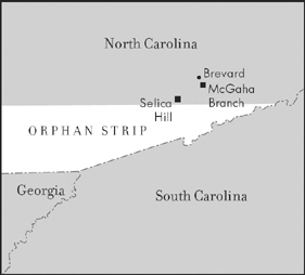
North Carolina-Georgia engagements
In 1810, with North Carolina solidifying its control, Georgia hired Andrew Ellicott, one of the nation’s foremost surveyors, to locate the 35th parallel. Milledgeville’s Georgia Journal reported in 1812 what his findings were rumored to be (and, in fact, were): “No official communication has yet been made by Mr. Ellicott to our Executive; but we learn that no part of Walton County belongs to this state.” Georgia took no official action in response to Ellicott’s survey. In fact, it came to act in ways that sought to render the dispute invisible.
During that time, James Brittain too began to disappear from the public mind. When he died (likely in the years near Ellicott’s survey), he was buried in what would become the family gravesite in Mills River, North Carolina. Today his grave is invisible, covered by tract homes.8
More pressing needs also erased his memory. In 1860 Georgia scrapped the constitution it had been using, which included a description of its boundaries, and replaced it with the constitution of the Confederate State of Georgia. It contained no boundary descriptions, since the last thing the Confederate states needed was conflict among themselves. Georgia’s Confederate constitution was replaced during Reconstruction with a constitution that also included no assertion of boundaries. In this instance, those writing this constitution were imposing an end to a national conflict; they too had no wish to stir up local trouble.
For the same reasons, regional historians minimized or totally avoided any reference to the Walton War, seeking to suppress the fact that the North Carolina militia was once led into battle against fellow countrymen from Georgia. One multivolume history of Georgia informed its readers, “For several years a bone of contention between Georgia and North Carolina was the matter of locating the 35th parallel of north latitude, recognized as the boundary line between the two states. In 1806, surveyors representing both states …” Even though 1806 was only two years after Brittain’s foray, this highly detailed history of the state simply skipped it.9 On the North Carolina side, even historians focused solely on the state’s western end ignored the event. One such historian acknowledged the Walton War but wrote of it:
Georgia, about December, 1803, created a county within this territory and called it Walton County. Georgia naturally attempted to exercise jurisdiction over what it really believed was its own territory, and North Carolina as naturally resisted such attempts. Consequently, there were great dissentions, the said dissentions having produced many riots, affrays, assaults, batteries, woundings and imprisonments. On January 13, 1806 …10
In both instances, the transition to 1806 leaves Brittain’s 1804 foray in the narrative’s dust.
In 1971 Georgia suddenly renewed its boundary dispute with North Carolina, though modifying its claim. It also took up a similar dispute with Tennessee. The North Carolina dispute was triggered to maintain consistency in Georgia’s boundary claim with Tennessee. That dispute had been triggered by Georgia’s need for access to the Tennessee River to help supply water to rapidly growing Atlanta, rising in the wake of the civil rights movement as the preeminent city of the New South. Reflecting that change, Atlanta’s leading African American newspaper followed the boundary challenge with equal concern. “Georgia Rep. Larry Thomason … chairman of the Georgia Boundary Commission, contends the state’s present northern boundary is about a mile south of where it should be,” Atlanta’s Daily World reported in September. Noting that the U.S. Geodetic Survey had announced a meeting to be held with representatives of the three states, the article continued, “Georgia has accepted the invitation and is waiting for responses from North Carolina and Tennessee.”
Apparently, Georgia is still waiting. No boundary adjustments have ensued. What has ensued, however, is an awakened awareness of the basis for the conflict, and with it the name of James Brittain has begun to reappear in historical accounts.