THERE WERE MANY REASONS to build railroads: to carry passengers and freight; to unite towns, villages, and nations; to make money; or simply to stop other companies from building them. The famous Indian hill railroads, however, owe their existence to a very particular phenomenon—the British colonists’ dislike of the hot Indian summer.
Since their inception in 1853, the railroads in India had quickly become a vital part of the way of life in the subcontinent, used by both the Indians and the British, though mostly in separate cars or trains. As the railroad network grew, the British realized that it could also be the answer to the nagging question of how to avoid the oppressive heat during the summer months. Leaving the towns in the summer for cooler areas in the hills had long been a habit of the colonists, but it was a long and arduous journey. Building the Indian hill railroads, which would climb perilously steep inclines to link the hill towns with the plains below, seemed the obvious, if ambitious, solution. Such a venture seemed impossible at first, however, as the hills in question—which included the foothills of the mighty Himalayas—had grades that appeared too steep to tackle. Yet as the 19th century wore on and railroad engineering became more and more sophisticated, it was soon felt that no mountain, ravine, or river could present any serious obstacle to the iron road’s inexorable progress.
The first, and still the most famous, hill railroad to be built in India was the Darjeeling Himalayan Railway (DHR). It linked Siliguri in the plains of the Himalayas (400ft/122m above sea level) with Darjeeling in the Lesser Himalaya mountain range (6710ft/2,045m above sea level), climbing nearly 1¼ miles (2km) in its 55-mile (88-km) journey. Construction began in May 1879, just months after the mainline railroad had reached Siliguri, and it aroused great interest in India. In March 1880, Lord Lytton, the British Viceroy of India, traveled on the first completed stretch of track, cheered on by huge crowds. The line was completed in two years, which is truly remarkable considering the challenges the engineers faced. For most of its length, the DHR ran alongside a newly built path, but while the first 7 miles (11km) was a gentle incline, after that the grade became much steeper, up to 1 in 23 (or 4 percent). This level of incline can be problematic for a railroad without extra support, such as a rack or a cable, but the DHR engineers avoided this by building a lighter, narrow-gauge railroad. Later they also added loops, in which the track passed over itself, and switchbacks, in which it reversed back on itself, to reduce the sharpness of the grade further. One of the four loops on the DHR was named Agony Point because of the perilous tightness of the bend and its proximity to the precipice of the hill.

Perhaps surprisingly, the DHR was extremely profitable right from the start. Not only did it carry British residents eager to escape the summer heat and tourists who immediately flocked to see the wonderful scenery, it also carried vast amounts of tea. In fact, the arrival of the railroads helped the local tea industry to thrive. Although the railroad was very slow, rarely reaching speeds of more than 15mph (24kph), it was still much faster than the bullock carts that used the road. As with the mainline Indian railroads, the hill railroads also had a military function: building railroads deep into the Himalayas enabled the British to establish control and create garrison towns that would protect the most remote parts of the subcontinent.
In the early days, the mail train left Siliguri at 8:25am and passengers were treated to an unparalleled experience as the train climbed up through the cloud and early morning mist, steadily navigating the steep grade to find the warmth and blue skies of Darjeeling. An early description in Railway Magazine in 1897 recounts an amazing climb up the Himalayan foothills:
And now we approach the culminating wonder of the line. At one place, we have been able to count three lines of rail below us which we have just traversed, and to see three more above us, up which we are going to climb, making in all seven lines of track (counting the one we are on) visible at one time, nearly parallel with each other at gradually rising heights on the mountain side. But now the wheels groan with the lateral pressure caused by a tremendous series of curves, and for a few breathless seconds, the train seems transformed into a veritable snake, as we pass ‘Agony Point’ and in so doing traverse two complete circles of such incredibly small diameter that the train, if at rest, would stretch round more than half of the circumference of one of them.

Today, the DHR is a designated UNESCO World Heritage Site, honored for its innovation and socioeconomic impact. It is also still a functioning railroad, carrying both local passengers—there is even a special school train, which transports children to schools in local towns—and countless tourists. The trains can be heard anywhere on the mountain up to Darjeeling, thanks to the loud horns that sound constantly, even managing to drown out the trucks and buses. If they are lucky, passengers can see Mount Everest in the distance, although the frequent mists and clouds make this relatively rare (this author spent a week there without so much as a glimpse of Everest). Incredibly, some of the original steam locomotives supplied by the British company Sharp, Stewart & Co. are still running, although they spend much of their time in the workshop at Tindharia, a third of the way up the line. The line has suffered from subsidence and landslides over the years and the lower section was closed in 2010 following a major landslide, which also washed away the adjoining road. Today, only the upper section from Kurseong to Darjeeling remains in operation.

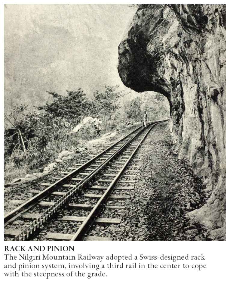
The next hill railroad project in India was the 3ft-3⅜-in (1-m) gauge Nilgiri Mountain Railway (NMR) from Mettupalayam to Udhagamandalam (more commonly known as Ooty) in Tamil Nadu, South India. It had initially been proposed as a garrison line way back in 1854 at the start of the Indian railroad age, but construction did not begin until 1894. The NMR was even steeper than the DHR, as the railroad had to climb more than 1 mile (1.6km) from the plain to the summit, over a distance of 26 miles (42km). Consequently, it took much longer to build than the Darjeeling line and entailed far more major structures, including 108 curves, 16 tunnels, and a staggering 250 bridges. It did not open fully until 1908. The steepness, which at some points reached 1 in 12 (or 8 percent), was too great for a locomotive to manage on its own and consequently for the first 17 miles (27km), between the towns of Mettupalayam and Coonoor, the line used a rack and pinion system to navigate the steep grade. This involved installing a third rail in the middle of the track, with teeth similar to those on a gear mechanism. A special toothed wheel on the locomotive then locked in to the rail, enabling it to grip and help to pull the train up the hill (see Climbing Mountains). Given the steepness of the line and its sharp curves, it was a very slow journey, taking five hours to reach Ooty at the top. As with the DHR, some very old steam locomotives still travel on the line today. In honor of that fact, the NMR joined the DHR as a UNESCO World Heritage Site in 2005, and they became known collectively as the Mountain Railways of India.
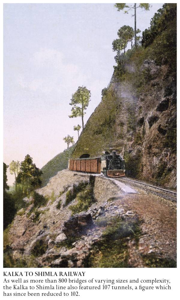
The third famous Indian hill railroad to be completed was the Kalka to Shimla line, opened in 1906. Shimla (or Simla as it was then known) was a much more important center for the British than Darjeeling or Ooty. By the 1830s, it had become a well-established summer residence for the British and was noted for its balls and other social highlights, attended by colonial officers and senior administrators. Although the roads up to the station were widened and improved with the construction of the Hindustan–Tibet highway in 1850, it was still a four-day journey from the plains up to Shimla. When, in 1863, Shimla became the official summer capital of India it meant that the whole paraphernalia of government, even the military, was moved between Calcutta and Shimla twice a year.
Due to Shimla’s importance to the colonists, it was vital that a railroad should be built up to the town, but it was a far more complicated proposition than the other two hill railroads. As with the DHR and the NMR, the Kalka to Shimla Railway was built to a very narrow gauge (in this case 2ft 6in/762mm) to make it lighter and to save construction time. Nevertheless, the railroad route from Kalka to Shimla involved the construction of more than 806 bridges and, although many were little more than culverts over streams, several were arched, multitiered structures rising from the bottom of deep valleys.
In fact, there is a sad legend about the longest tunnel on the line (number 33), which is nearly ¾ mile (1.2km) long. Colonel Barog, the engineer of this tunnel, ordered digging to begin at both ends, but the two sections were not properly aligned so they didn’t join up. Barog was fined a nominal amount (1 rupee) by his employers, but he could not cope with the stigma of his failure and committed suicide. Another engineer completed the tunnel, but it was named the Barog Tunnel in memory of the original engineer. Despite this minor mishap, the 60-mile (97-km) line was a feat of engineering and came to be known as the “British Jewel of the Orient.” The prolific railroad writer O.S. Nock traveled on the line in the 1970s and was amazed at the difficult terrain that the line traversed. He wrote:
The geology of the area is highly erratic. The formation consists of a heterogeneous mass of boulders, clay containing small quantities of sand and other debris, while in other locations it is a solid rocky mass. There is frequent trouble during the monsoon season from slips and subsidence, and these sometimes occur without any preliminary warning because of the peculiar geology and the unpredictable hydrology of the area.
He goes on to explain that he found the use of the word “erratic” by local geologists rather strange until he traveled up the line and saw for himself that the area posed particularly unique difficulties for the construction of a railroad. It was worth it though. The line is one of the most impressive in the world with spectacular views of the Himalayan foothills and in 2008 the line was added to the UNESCO World Heritage Site, the Mountain Railways of India.
Several other hill railroads were built during this era and are still thriving today. These include the Kangra Valley Railway (opened to passengers in 1929) in the sub-Himalayan region; the Matheran Hill Railway (built in 1907), which ascends the western Ghats mountain range in south; and the Lumding to Silchar line, built at the turn of the 20th century, lying deep inside the state of Assam, in the Barak river valley of the Cachar Hills. All of them are spectacular railroads, providing a vital connection between remote hill towns and the lowlands. However, Indian hill railroad-building is not just a thing of the past: the Kashmir Railway, which aims to connect the region in the outer Himalayas with the rest of the country, is an ongoing challenge. First suggested in 1898, the proposed route includes major earthquake zones, extreme climates, inhospitable terrain, and is subject to continued conflict between India and Pakistan over territorial rights to Kashmir. These geographical and political difficulties combined to delay the start of building work until the late 20th century and completion is not estimated to happen until 2017, well over a century after the line was first proposed.
