Chapter Twenty-Three
INTRODUCTION
Anthropogenic threats to shallow-water coastal ecosystems such as coral reefs, sea-grass beds, mangroves, intertidal mud flats, rocky shores, and beaches (among others) are numerous. Addressing the serious issue of marine and coastal degradation in Indonesia will require development and implementation of new management plans for the coastal and marine sector, and integrated marine and coastal zone management is the key process. What is evident from a number of case studies, such as Kepulauan Seribu (Brown 1986), Jakarta Bay (Tomascik et al. 1994; Suharsono and Tuti 1994) and the inner Ambon Bay, is that side-stepping current environmental issues and spending limited resources to speculate about issues such as the upcoming climate change is questionable, since many shallow-water ecosystems will be lost even before any significant changes in sea level rise are manifested. The following is a list of key environmental concerns in Indonesia which require immediate attention. Note that the issues are not arranged in any order of priority, since different areas in different parts of the archipelago will be affected by different sets of conditions. However, these issues (in whatever order they may be) are relevant to all of Indonesia.
1. Increased water turbidity and sedimentation in shallow-water marine and coastal environments due to inappropriate agricultural practices, deforestation, industrialization and urbanization.
2. Overexploitation of renewable marine and coastal resources (e.g., coral reef fisheries, coral extraction).
3. Destructive (legal and illegal) fishing practices.
4. Eutrophication and other chemical stresses from rapid coastal development (agriculture, industrialization, urbanization).
5. Removal of keystone species.
6. Alteration of circulation patterns (i.e., coastal engineering works, etc.).
7. Inappropriate land-use patterns in upper watersheds and the coastal zone (agriculture, forestry, industrialization, urbanization).
8. Waste disposal (point source pollution).
There is no question that shallow-water coastal ecosystems, such as coral reefs, have adapted through their long evolutionary history to a wide spectrum of environmental disturbances. These include cyclical fluctuations in sea levels and temperatures associated with climatic changes and tectonism. What is, however, far from certain, is whether many anthropogenically stressed coral reefs (and other marine and coastal ecosystems) will be able to adjust to the new environmental conditions, which are expected with the predicted global climate change.
Wilkinson (1993) has been forcefully advocating that coral reefs the world over are rapidly declining, and that within the next 20 years local extinctions are probable, unless immediate action is taken. This gloomy outlook is supported by numerous examples from Indonesia, where rapid population expansion has led to coastal degradation (e.g., Jakarta Bay). However, there is also hope for the future, since in many parts of the archipelago, where people have lived for centuries (e.g., Banda Islands, Banggai Islands, Berau Islands, etc.), coastal ecosystems still flourish, suggesting that people and coral reefs can coexist, provided human populations do not strain the carrying capacity of these ecosystems. According to Wilkinson (1993), the greatest population and extermination threats coincide with the centres of coral reef biodiversity, such as Indonesia and the Philippines. During the 7th International Coral Reef Symposium in Guam (1992), Wilkinson (1993) estimated that about 10% of the world's reefs are already degraded, and went on to classify the world's coral reefs into three categories:
Critical. About 30% of coral reefs are at a critical stage and will be lost in the next 1020 years, unless the current levels of anthropogenic stresses are removed or diverted.
Threatened. About 30% of coral reefs are in the 'threatened' category and will disappear in 20-40 years, if populations and associated stresses continue to increase at current rates.
Stable. Only about 30% of the world's coral reefs are considered as 'stable', and it is expected that they will remain so for a long time. Reefs in stable areas may act as reservoirs of coral reef larvae.
Wilkinson et al. (1994) placed all Indonesian reefs into the 'critical' and 'threatened' categories. The relatively dark picture painted for the future of Indonesian coral reefs needs to be interpreted with caution, but this does not detract from the serious problems facing Indonesian reefs. Wilkinson et al. (1994) provide a large-scale hypothetical scenario which should be taken seriously, even though their classification is greatly oversimplified. Most areas in the eastern regions of Indonesia have not been surveyed in detail, and the majority of survey sites used to arrive at their predictions were located in close proximity to human population centres. It should also be kept in mind that the actual areal dimensions of Indonesian coral reefs are still highly speculative.
INDONESIAN CORAL REEF BASE
The Indonesian coral reef database consists of biological data recorded at 324 locations spread throughout the archipelago (fig. 23.1; table 23.1). The survey was initiated in 1987, and employs the use of the Benthic Lifeforms Line Intercept Transect(LIT) technique. The procedure, as employed originally in Indonesia by Devantier (1986), uses a classification system based on structural attributes of benthic life-forms (e.g., corals, sponges, etc.), rather than species-level (i.e., taxonomic) data. Thus, the data provide a morphological description of the benthic community (table 23.2). The main advantage of benthic lifeforms LIT technique is that the life-form classification system used does not require a specialist to collect useful information. In addition, the technique requires little equipment, thus it is economically attractive, and more importantly, the technique can provide a reliable estimate of percent cover data.
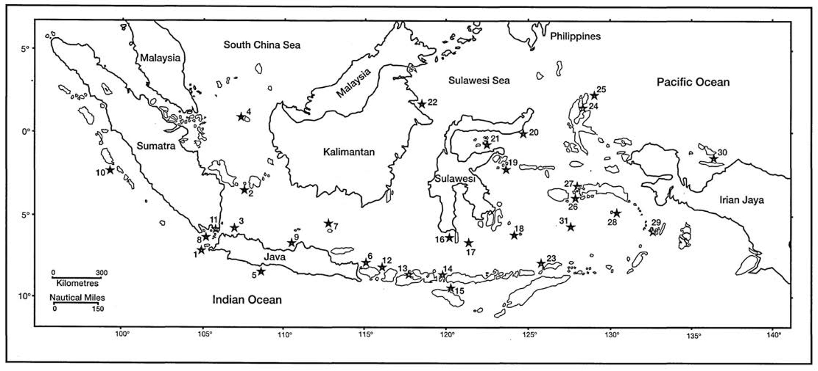
Figure 23.1. Location map of Indonesian coral reef survey sites for table 23.1.
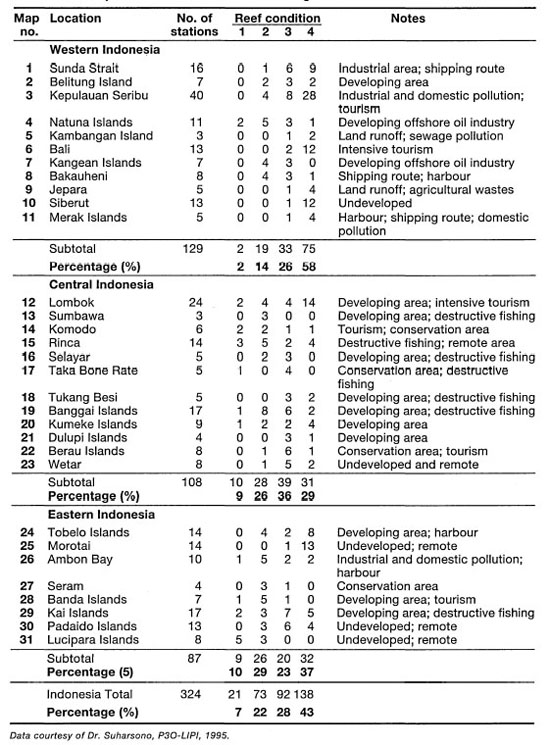
Table 23.1. The status of coral reef ecosystems In Indonesia. Reef condition: (1) Excellent: living coral cover 75%-100%; (2) Good: living coral cover 50%-57%; (3) Fair: living coral cover 25%-50%; (4) Poor: living coral cover 0%-25%. Numbers represent the number of coral reef survey sites. For site location refer to figure 23.1.
The benthic lifeforms LIT technique was designed to be used primarily to obtain an estimate of cover of a specific sessile benthic lifeform and/or an object (e.g., coral, sponge, algae, substrate type, etc.), or a group of lifeforms and/or objects within a specified area (English et al. 1994). More important, however, is that the method was designed for monitoring purposes, meaning that a particular site or a location chosen for the study will be resurveyed every year, or at least every two years (English et al. 1994). Used as a monitoring tool, the benthic lifeforms LIT is a very inexpensive and powerful tool that is able to detect changes in percent cover of the various biotic and abiotic components of the benthic coral reef community.
One of the major disadvantages of the benthic lifeforms LIT technique is in the standardization of some lifeform categories (English et al. 1994). This is especially true in high-diversity regions, such as Indonesia, since morphological attributes of many sessile coral reef organisms, especially the reef-building corals, often change in direct response to prevailing environmental conditions (i.e., habitat type). The two main disadvantages of the benthic lifeforms LIT technique are:
1) The method is useful only to answer questions concerning percent cover or relative abundance; and
2) The method is not appropriate for collection of demographic attributes of benthic communities (i.e., reproduction, recruitment or growth) (English et al. 1994).
Table 23.2 illustrates, however, that the database does contain valuable ecological information. To date, the analysis of the national coral reef database has focused primarily on the percent coral cover component. Thus far, none of the ecological attributes that may be extracted from the data set have been analyzed to introduce an ecological component into the analysis and interpretation of the existing data. Perhaps the most serious deficiency with the existing available data set is the lack of corresponding environmental and socioeconomic data. It should be made clear, however, that while the methodology used thus far to collect the coral reef ecological data is sound, the information that has been extracted and presented is not sufficient to answer many key management questions.
The results that have been presented thus far must be interpreted with a great deal of caution, and as a result have a questionable management value. Specifically, the percentage coral cover alone is clearly not sufficient to classify a particular coral reef community as either 'poor' or 'excellent' without a statistical comparison to earlier conditions. The present classification system (i.e., poor, fair, good and excellent) has implicitly linked human values (i.e., it is heavily anthropocentric) to the percent coral cover. Thus, all coral reefs with low coral cover are automatically assumed to be degraded, irrespective of the existing environmental and ecological condition of the reef system, which in fact remains unknown.
The main shortcoming of the present classification system is the lack of ecological and environmental information on the systems being described. Careful examination of the sampling areas reveals that a comparison is being made between very different reef systems, which developed under very different environmental conditions. To put it simply, low percent coral cover does not necessarily imply that the system is "damaged or degraded", and conversely, a high coral cover does not necessarily imply that the reef system is not overexploited. Whether coral reefs are physically damaged, overexploited (ecological damage), or both, are key questions that a manager needs to know. The current use of the classification system cannot provide this type of management information.
Perhaps more serious is the danger of using the existing "coral reef health" classification system in identifying and selecting suitable high biodiversity coral reef sites for inclusion in the national 'Marine Protected Areas' system program (e.g., coral refuge areas or seed areas). Based on past research in Indonesia, it is possible that coral reefs with the highest percent coral cover (i.e., Category 1: Excellent) may not be the most optimal biodiversity sites and/or seed-source sites, since in regions where there are few natural disturbances, coral reefs tend to be dominated by monospecific coral communities (i.e., low diversity) with exceptionally high coral cover (fig. 23.2; fig. 23.3). Thus, while scoring high in terms of percent live coral coverage, they are of limited conservation value from a biodiversity perspective. Conversely, coral reefs with relatively low percent coral cover may in fact have higher biodiversity and conservation value than coral reefs with 100% coral cover (fig. 23.4). Due to the severe shortage of scleractinian (coral) taxonomists in Indonesia, ecological relationships on Indonesian reefs are poorly understood. However, species/cover relationships in many sheltered environments throughout the archipelago (i.e., biologically controlled communities; Sanders 1968) fit well with the predictions of the intermediate-disturbance hypothesis (fig. 23.5) (Connell 1978, 1979). According to the latest information from ICLARM (International Center for Living Aquatic Resources Management), the average percent cover (based on a global database) by scleractinian corals on an coral reef is between 35% to 50% (J. McManus, pers. comm.). Based on our surveys, it appears that while many of the coral reefs in the eastern regions of Indonesia have maintained their structural integrity (i.e., high coral cover and diversity of reef-builders), the reef-associated communities such as fish and invertebrates (especially sea cucumbers) are heavily overexploited (fig. 23.6).
Table 23.2. Benthic lifeform categories and codes used by the ASEAN-Australian Marine Science Project: Living Coastal Resources.
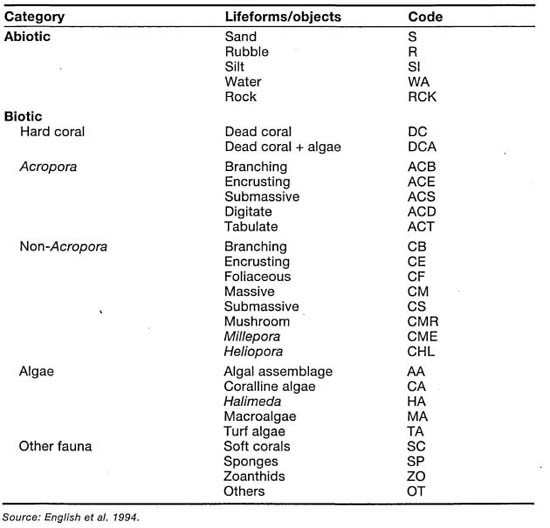
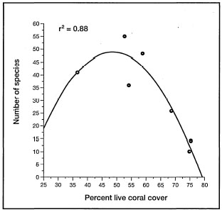
Figure 23.2. Relationship between percentage coral cover and coral diversity in an undisturbed region of the east Banda Sea, Banda Islands.
Source Sutarna 1990.
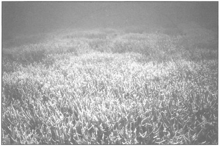
Figure 23.3. Many sheltered reefs in the archipelago are dominated by extensive monospecific stands of Acropora with high coral coverage but very low diversity. Gunung Manuk, east Banda Sea.
Photo by Tomas and Anmarie Tomascik.
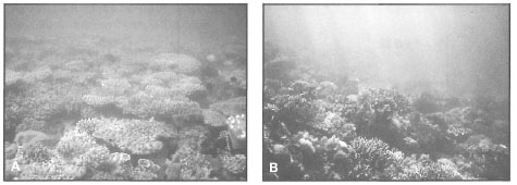
Figure 23.4. Coral reefs with low scleractinian coral coverage are not necessarily damaged or degraded. A) This highly productive shallow patch reef in the Berau Islands is dominated by a soft coral community at the outer reef flat and reef crest. B) On the deeper fore-reef slope scleractinian corals increase in abundance and cover.
Photo by Tomas and Anmarie Tomascik.
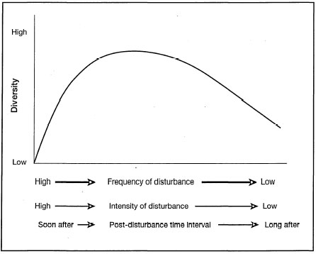
Figure 23.5. The intermediate-disturbance hypothesis.
Connell 1978, 1979.
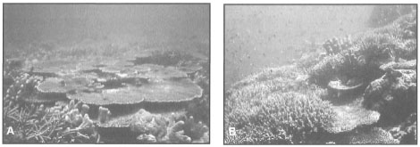
Figure 23.6. Many reefs throughout the archipelago are overexploited. A) Coral reef in Salabangka, Central Sulawesi. Note the high live coral cover (70%-85%). Using current percent-cover criteria, this coral reef would be classified as being in good condition. In fact, this reef has been overexploited to the extent that most reef fish have been removed. B) While habitat plays a key role in determining fish abundance and diversity on coral reefs, reef fish are a key component of coral reef ecosystems. Under normal conditions Indonesian coral reefs support high diversity and biomass of reef fish.
Photos by Tomas and Anmarie Tomascik.
CORAL REEFS: ROBUST OR FRAGILE?
The nature of coral reef communities, in terms of their fragility or robustness (i.e., their sensitivity to natural or anthropogenic perturbations and the rate of their subsequent recovery from these perturbations), has generated a number of debates in the past. From a purely geological perspective, coral reefs must be considered as relatively robust systems to have survived millions of years of continuous environmental change (e.g., global temperature and sea level fluctuations), especially during the early Tertiary and the Plio-Pleistocene ice ages. However, when viewed in terms of years or decades, coral reef communities seem to be relatively fragile systems, since major community changes are frequent over relatively short time intervals.
Composition and zonation of coral reef communities are unstable on the scale of human lifetimes, but stable on average over thousands to hundreds of thousands of years.—JACKSON 1992
At this point, it may be pertinent to point out that in terms of coral reef resources management and ecosystem conservation, it is more than sound to view coral reefs as fragile systems irrespective of the current scientific debate. Considering the ecological, social and economic value of Indonesian coral reef ecosystems to the society as a whole, and our still-limited knowledge of their ecology, it is essential to apply the most appropriate management options available (a conservative approach) to guarantee their future structural and functional integrity. It would be tragic, and a great disservice to future generations if, because of some "academic" scientific debate, many Indonesian coral reef communities become "doomed" through anthropogenic impacts over the life span of this and the next generation. Whether Indonesian coral reef ecosystems will survive the next one million years is really not the main issue facing us; looking at their successful history, we may conclude that they most likely will, in one form or another. However, the current onslaught of anthropogenic impacts (e.g., pollution and direct physical damage) and the continually rising human population (e.g., overexploitation) are having a significant impact on reefs worldwide. The question that we should be asking ourselves is how long, under these conditions, will coral reef communities be able to support the traditional resources and amenities upon which millions of coastal people depend for their livelihood. This type of reasoning apparently escapes some contemporary coral reef ecologists who are forcefully advocating robustness of coral reef communities, and suggesting that anthropogenic impacts are not as serious or pervasive as natural perturbations. Richmond (1993) has stressed that major differences do exist between the effects of natural and anthropogenic disturbances, a fact usually ignored or downplayed by the proponents of 'robustness'. Furthermore, synergistic effects between natural disturbances, to which corals are well-adapted through their long evolutionary history, and various anthropogenic impacts, which are novel stresses from a coral's point of view, significantly alter the conditions required for normal recovery.
The long, successful history of coral reef communities in regions subjected to frequent cyclones (e.g., the Great Barrier Reef), tells us that they possess efficient recovery capabilities. This inherent healing capacity of coral reef communities has, however, evolved within a certain range of environmental conditions spanning millions of years. Many anthropogenic impacts are additive and are outside the range of conditions in which coral reefs evolved, thus they are a more insidious threat to the survival of coral reefs than all the disturbances that Mother Nature can independently unleash at them.
Under natural conditions, coral reefs are exceptionally robust and self-repairing biogenic structures, that dissipate enormous amounts of kinetic energy by breaking waves and deflecting currents. The structural and functional characteristics of coral reef communities are affected by a number of physical and chemical factors that can be greatly modified by various coastal development activities. As long as the anthropogenic disturbances mimic and emulate natural disturbances in terms of intensities and frequencies, they are, at most, of local significance. However, most anthropogenic disturbances (e.g., physical, chemical or biotic) are more insidious because they do not mimic natural disturbances, but rather produce secondary effects which are difficult to predict.
Contrary to some views, coral reef communities, while being resilient to a wide spectrum (in intensity and frequency) of natural abiotic and biotic environmental disturbances (e.g., tropical storms, earthquakes, freshwater runoff events, outbreaks of Acanthaster, etc.), are very sensitive to environmental impacts associated with anthropogenic (human) activities, especially under chronic stress situations (i.e., persistent stress) (Brown and Howard 1985; Gortes and Risk 1985; Tomascik and Sander 1985, 1987a,b; Hallock and Schlager 1986; Tomascik 1990, 1991; Bell 1992; Lapointe et al. 1993; Richmond 1993; Tomascik et al. 1993; van Woesik 1994). It is essential to recognize that because many, but not all, coral reef communities, dominated by animal-plant symbionts (e.g., hermatypic corals; giant clams -Tridacna spp.; colonial tunicates; sponges; and foraminiferans), have evolved in clear and "relatively" oligotrophic tropical waters, they are highly sensitive to excess nutrient inputs and other pollutants associated with anthropogenic activities. Furthermore, recruits of many coral reef organisms (e.g., fish and corals) frequently originate from adjacent coral reef areas located up-current. This phenomenon has significant conservation and management implications, since it cannot be assumed that protecting only one area of an ecosystem from anthropogenic impacts will ensure its long-term viability.
THE HUMAN - CORAL REEF ASSOCIATION: THE BAJAU
The early indigenous people inhabiting the Indonesian Archipelago, as well as other tropical island chains, were quite familiar with coral reefs through their daily lives. Remains of marine shells and other organisms have been found in prehistoric caves in the Philippines (White 1987), and they most likely occur throughout the tropical regions. Perhaps no other people have had a closer link with coral reefs than the nomadic boat people, or the 'Sea Nomads' (sometimes generically referred to as orang laut or "the sea folk"), of the Indonesian Archipelago (fig. 23.7). The largest group of 'Sea Nomads' in the Indonesian Archipelago are the nomadic 'Bajau', distributed widely from East Kalimantan to the Moluccas. The Bajau rely almost 100% on the sea, mainly on the shallow-water coastal environments, for their basic daily sustenance, yet they employ only a few very primitive fishing techniques (figs. 23.8 and fig. 23.9) (Sopher 1977), a fact that attests to their intimate knowledge of the sea. A detailed account of the history of the Bajau people and their unique way of life in Southeast Asia is given by Sopher (1977), who points out that "...for the Bajaus the collecting of sea products is a continuous operation, and they work hard at it."
Because of their nomadic way of life (i.e., small family groups moving about from one island chain to the next, catching fish and building boats), it is unlikely that, in the past, these people had a measurable impact on the shallow-water marine and coastal communities on which they depended for survival. However, the shift from the nomadic way of life to sedentary (fig. 23.10), and from the use of simple fishing techniques to more economically profitable, but destructive alternatives (fig. 23.11), has resulted in ever-increasing pressure on the once abundant marine resources, such as sea turtles, dugongs, sea cucumbers (tripang), giant clams (Tridacna), top shell (Trochus niloticus), etc., which were the backbone of the Bajaus' trade with other coastal communities. New economic pressures, associated with a sedentary way of life and new development, as well as rapid population increase of coastal communities during the past few decades, created a need for more economically profitable, thus more 'catch-efficient' fishing techniques. As a result of the changing lifestyles and new development that slowly trickled into these once remote areas, many of the shallow-water marine and coastal habitats, like the coral reefs, are at present overexploited by the same people that once lived in relative harmony with the sea (fig. 23.12).
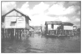
Figure 23.7. The Bajau people have a long history of association with Indonesian coral reefs and other coastal ecosystems. In the past the Bajau way of life was relatively harmonious with nature, however, with changing lifestyles and a growing population, the relationship is becoming unbalanced to the detriment of coral reefs and associated shallow-water habitats. Traditional Bajau sea village in Central Sulawesi.
Photo courtesy of Pak Simon, LITBANG.
Figure 23.8. Collecting sea cucumbers for the lucrative export bechede- mer market. Due to market forces, many holothurian species throughout the archipelago are now heavily overexploited.
Photo by Tomas and Anmarie Tomascik.
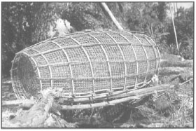
Figure 23.9. The use of fish traps is one of the most common fishing techniques. Large bamboo fish trap on the north coast of Ambon, Moluccas.
Photo by Tomas and Anmarie Tomascik.
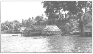
Figure 23.10. While many Bajau families spent most of their time on their boats, rarely venturing onto land, many Bajaus have settled in small coastal villages. Salabangka Islands, Central Sulawesi.
Photo by Tomas and Anmarie Tomascik.
The fascinating history of the Bajaus of the Indonesian Archipelago illustrates that coral reefs played an important role, as they continue to do so today, not only in providing basic sustenance to coastal communities, but also in protecting the various coastal communities from the wrath of the seas (Sopher 1977; Maragos et al. 1983). Even though the close reliance of many coastal peoples on the coral reef systems goes well back into early history, it is only relatively recently that we are beginning to understand and comprehend what a coral reef is.
Coral reef ecosystems have become very valuable tourist attractions, generating significant foreign exchange earnings and local income quite apart from fishing activities (White 1987). In addition, coral reefs are a significant source of sand for many beach ecosystems, especially on low islands, and protect valuable beachfront properties and industrial sites from natural elements of the sea (Goreau et al. 1979; Maragos et al. 1983; Carpenter and Maragos 1989). The role of coral reefs as natural self-repairing breakwaters may become more significant with the expected sea level rise that is anticipated to occur along with the predicted anthropogenically-induced global climate change (IOC 1991). Therefore, as suggested by Clark (1983), the fundamental goal of coastal conservation and management must be to maintain coastal ecosystems (i.e., coral reefs, seagrass beds, beaches, sand dunes and mangroves) in their best condition, or at a level of best achievable ecosystem function, which means as near to the natural condition as possible.
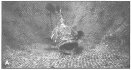
Figure 23.11. High profits associated with the live grouper trade have resulted in widespread damage to coral reefs and grouper populations. The use of cyanide in the live grouper fishery is a serious environmental concern. A) Holding cages for grouper in the Salabangka Islands, where the reefs are heavily overexploited. B) Groupers are held in floating cages for weeks until they are picked up by specially designed boats from Taiwan and Hong Kong.
Photo by Tomas and Anmarie Tomascik.
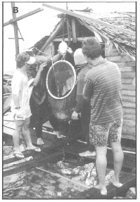
Figure 23.12. Many Bajaus have settled on offshore islands in large communities. The 1.3-km-long wooden bridge connects two Bajau villages, alabangka village on Pulau Kaleorang (at front) and Bunginkela village on Pulau Bunginkela (in the distance). Salabangka Islands, Central Sulawesi.
Photo by Tomas and Anmarie Tomascik.
Carbonate platforms, the geologic manifestations of reef-building organisms, have existed on Earth for eons, and they will continue to exist despite the detriment by Homo sapiens. Whether the architects and master builders of these magnificent biogenic structures, currently the scleractinian corals and calcareous algae, will continue to do their grand work seems to have been placed in the hands of a creature that is rapidly altering the ecological and chemical balance of this planet. Homo sapiens has become an 'epidemic' of global proportions, if viewed from the Gaia perspective (Lovelock 1979).
Traditional Knowledge
There is an idealistic myth floating in conservation circles which supposes that early people, who by necessity lived close to nature (e.g., Bajaus), developed harvesting techniques (i.e., management) that were not overexploitative. To a limited extent this may be true, if viewed in historical terms and for certain regions only. However, the often-invoked corollary that the early people understood the 'system' and therefore developed the techniques to manage it, is largely a myth. There is no evidence that traditional coastal people understand what a reef is, in an ecological sense, and how it directly relates to the fish and other animal productions, except in the most general terms.
The indigenous people, especially traditional fishermen, are very knowledge able about areas where there are usually good concentrations offish, and they have learned to find these spots. Coastal fishermen are generally attuned to the yearly cycles in the abundance of many commercial reef and reef-associated fish species. Temporal and spatial fluctuations in the abundance of coral reef and reef-associated fish are frequently related to biological cycles, such as seasonal or lunar spawning cycles (Johannes 1989). It is important to realize that this accumulated knowledge is not very useful in present-day conservation efforts, if these same people who understand the life cycles of their biological resources do not under stand that the continued viability of these resources is totally dependent on the health of the reef system as a whole. The fisher folks know a great deal about where and when to go to get fish, but not necessarily why reef fish need a healthy coral community. This general lack of understanding of the holistic concept of coral reef systems, the great interdependence of reef communities, is one of the many reasons why we see rapid degradation of coral reef communities worldwide.
Overexploitation of Resources
In the past when fishing was evenly spread through the small coastal communities, the knowledge of the fish cycles was key for the survival of many coastal people. However, with the rapid rise in coastal populations, thus intensification of fishing pressures, this knowledge has also added to the problem of overexploitation. While the coastal fishermen do understand the life cycles of fish, and other resources, their understanding of the carrying capacity is in question. In any case, the over riding need to put food on the daily plate in an ever-expanding population transcends any notion that traditional fishing techniques are the answer. Management techniques of marine and coastal resources cannot be regressive or static, but they must change along with the increasing population and changing use patterns. The traditional (adat) resource management systems (sasi) that have been in use throughout the Moluccas for centuries are collapsing island by island due to increasing human populations and strong influence of external market forces.
An example of overexploitation of coral reef resources can be found along the east coast of Central Sulawesi, where the once nomadic Bajaus settled in the Salabangka Islands. In terms of environmental integrity the shallow-water marine and coastal habitats, such as the coral reefs, seagrass beds and mangroves that fringe long stretches of the coastline, are in prime condition (i.e., applying the percent-cover concept), and are among the most productive (i.e., primary production) shallow-water systems in the area. However, when we consider the low abundance of economically valuable families of coral reef fish and invertebrates on the reefs, it is apparent that these, and many other coral reefs throughout the archipelago, are being heavily overexploited. Many reef fish (e.g., Caesionidae [fig. 23.13A], Siganidae, Lutjanidae [fig. 23.13B], Serranidae, Lethrinidae, Scaridae, Haemulidae) and invertebrates (e.g., Tridacnidae [fig. 23.14A], Trochidae [fig. 23.14B], Holothuridae, and Cephalopoda [fig. 23.15]), that were once common are now becoming rare on many reefs, and more destructive fishing methods are now being used, since the traditional techniques are no longer economically viable. Another danger of overfishing is ecological damage which may become irreversible. For example, on many reefs and seagrass beds from which sea cucumbers (e.g., Bohadschia argus, B. marmorata, Stychopus variegatus [fig. 23.16A], Thelenota ananas, Holothuria [Microthele] nobilis, H. [Metriatyla] scabra, Actinopyga miliaris, A. echinites) were removed by local fishermen, major shifts in the structure of benthic commu nities occurred. In many seagrass beds, the once-abundant sea cucumbers were replaced by economically unimportant starfish Protoreaster nodosus (fig. 23.16B).
Box 23.1. The Bajau people.
R.H. Djohani, The Nature Conservancy, Indonesia Program, Jakarta.
The Bajau are among the last of the once widespread, boat-dwelling people of Southeast Asia. Historically, their lives have been intricately linked to the sea. Living on boats and fishing using traditional methods for many centuries, the Bajau remained in equilibrium with the surrounding marine environment. Their traditional subsistence technology was basically an adaptation of hunting and gathering techniques to a marine environment. Accounts of early Chinese and European travelers reveal that boat-dwellers once inhabited the waters of the Mergui Islands, Singapore, Johore, Bangka, Sulawesi, and the Sulu Islands (Sopher 1977).
However, the situation has changed. The Bajau are now exposed to new markets, products and technology which are altering their existence. Today, most of these people have abandoned their boat-dwelling way of life and have settled on the land. Boat-dwellers still remain in the Mergui Islands, Sulawesi, and Sulu, but these people, too, are rapidly abandoning their lifestyle and, if present trends continue, the sea nomad culture will eventually disappear from Southeast Asia. There are only a few enclaves of boat-dwellers, scattered throughout insular Southeast Asia, who spend their entire life on small boats (perahu), totally dependent on what the sea has to offer. The name Bajau is applied to both those people who now have a permanent dwelling on land and to those who still live on boats. More and more Bajau people have settled along the coastlines of the Indonesian Archipelago. Their villages on stilts have become familiar features along the coasts of Sulawesi, Kalimantan Barat, Nusa Tenggara Timur, and Halmahera. Fishing is the basis of the Bajau subsistence economy. The fishing techniques of the boat-dwellers living in Southeast Sulawesi are still very traditional. They include line-fishing (pancing), spears (panah, sero) and traps (bubu), which are common methods for fishing in shallow waters. Reef fish, crabs, lobsters and sea cucumbers are caught in this way. Bajau villagers have three types of fishing grounds which are distinguished according to distance from the village:
· Palilibu: fishing close to the village so the fishermen return home after a few hours.
· Pongka: fishing takes place at a greater distance from the village and the fishermen only return home after several days.
· Sakai: fishing takes place at a very remote distance from the village, therefore the fishermen are absent for several months and occasionally away for up to a year.
Bajau fishermen may take their families along during sakai. The Bajau families live on boats and in temporary stilt constructions on the reef during such long journeys. Sakai can take Bajau fishermen into Australian waters. Such fishing patterns may have developed from restraints on exploitation imposed by the community as a means of conserving limited resources, although this is disputable. Under ideal circumstances, over-exploitation of fishing grounds by Bajau villages using traditional techniques is avoided due to the dispersed pattern of fishing.
The sea has various levels of significance for the Bajau people. The sea is their home. The Bajau boat-dwellers are born at sea and spend their entire life in the vicinity of vast oceans, but the dead are buried on land. The sea is a source of food for the Bajau. Fish, molluscs, and sea cucumbers form their main diet. The sea is also their friend, who helps them navigate unknown waters. Over time, the Bajau have acquired the maritime wisdom necessary to forge their way through the Indonesian Archipelago. Yet the Bajau fear the sea because of its waves and storms. Their overall respect for the sea has also given rise to several taboos.
Sacred places at sea where people seem to disappear into the depths of the oceans are still respected. Consequently, the Bajau do not fish in these areas. Circumstances have led to the emergence of other values and taboos in Bajau villages, often resulting in a locally protected area or animal. The growing extent of permanent Bajau settlements along the coast requires clear demarcation of fishing grounds among neighbouring families and villages to avoid conflicts about the fish catch. A boundary system for fishing grounds among the Bajau communities in the Togians has been identified. Fishing grounds have been allocated to each village and the boundaries are respected by other villages. Should outside fishermen want to fish in these fishing waters, permission is asked from the village leaders. Community control over the fishing areas seems to be very efficient.
In other areas, new taboos with a protective influence have arisen. For example, the Bajau on the island of Sumbawa no longer collect the black coral which is found in deeper waters (50 m) because they now associate collection of the coral with the onset of sudden and permanent pains in their knees and arms. The misuse of scuba-gear has led to such decompression sickness symptoms among the Bajau. Often, they dive too long and too frequently, using ill-maintained compressors. In several cases, Bajau fishermen have been permanently paralyzed and some did not survive. In the minds of the Bajau, the black coral seems to be cursed and a taboo on the collection of this coral was placed by the community.
The Bajau have survived for many centuries on the open seas. Every aspect of their life was based upon their relationship with the sea. The sea nomads relied on their maritime knowledge, values and ideas, as did their ancestors. This marine cosmology guided the lifestyle of these seafaring people who lived in harmony with their environment. The development of global trade and new technologies has altered many societies. The sea nomads are no exception. Settlement ashore has led to new issues, ideas, and also to the transformation of taboos and activities among the Bajau.
It is important to recognize that the local people can play an integral role in reef conservation, since it is they who are dealing with the day-to-day management of the marine environment and have a deep knowledge of the sea. An inventory of fishing grounds made with the help of the Bajau people would be an effective participatory planning process for the design and enforcement of fishing grounds and coral sanctuaries in many areas in Indonesia. Although their traditional lifestyle, faced with outside pressures, may not guarantee a continuation of sustainable exploitation, the Bajau are a part of the national history and development of Indonesia. Their intimate knowledge and affinity with the sea is unique and important in Indonesia. The Bajau are one with the Archipelago because the sea is their home.
Whether the traditional tenure laws (adat) that govern the harvesting of some natural resources, in some parts of Indonesia, came about as a result of cognised need for conservation (i.e., knowledge of carrying capacity implied), or as a result of purely cultural considerations, as a means to reduce potential conflict among various groups that otherwise would indiscriminately harvest all economically valuable resources, is not clear. When applied as intended, the sasi system does work, at least for the Trochus niloticus fishery. The three-year sasi system, which is a three-year-long close season between harvests (size limit is imposed during open season), as practiced in the Banda Islands is in fact attuned to the life cycle of the gastropod. T. niloticus attains sexual maturity in three years, and thus the sasi system allows reproduction of mature animals before they are collected. Unfortunately, increase in human population, the collapse of the nutmeg industry (the backbone of Banda's economy) and severe pressure from external market forces (i.e., high market value of Trochus shell) have contributed to the collapse of the sasi system. While re-implementation of the sasi would be a step in the right direction, it would not address the root of the problem. Small-scale interventions are needed (e.g., culture of Trochus) to provide alternative means of livelihood and more efficient use of existing resources.
Tridacna Exploitation in East Kalimantan
The inhabitants of Darawan Island, East Kalimantan, with the support of the local government and at the suggestion of a PHPA representative from Jakarta, have been, for the past few years, collecting Tridacna shells, on a massive scale. The large patch reef complex that forms a barrier reef along the coastline of East Kalimantan is a highly productive system. Clear and nutrient-rich waters support diverse reef communities, and the intertidal reef flats are a prime habitat for a number of tridacnids such as Tridacna squamosa, T. gigas, T. maxima, Hippopus hippopus and the very rare and the most valuable of all giant clams, H. porcelanus. The tridacnids, although protected species in Indonesia, are now used to feed juvenile green turtles (Chelonia mydas) in a head-starting program of highly questionable conservation value. This is an example where a local extinction of a group of reef organisms (i.e., Tridacna) is imminent, unless the practice is stopped. Note that local extinctions of tridacnids are widespread throughout the archipelago.
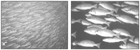
Figure 23.13. A) Fusiliers (Caesio teres) are one of the most economically important coral reef fish, which are frequently found in huge zooplankton-feeding schools in mid-water just off the reef slope. These large schools are the main target of illegal and highly destructive reef-bombing. B) Snappers (Lutjanus kasmira) are commercially important reef fish often seen in large schools on the reef. They are found in a variety of reef habitats, from the shallow reef crests to the deep outer reef slopes. L kasmira feeds at night, and is one of the most common fish taken by night fishermen.
A) Photo by Anmarie and Tomas Tomascik. B) Photo courtesy of Ron and Valerie Taylor.
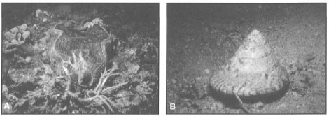
Figure 23.14. A) The giant tridacnid bivalves are becoming rare in many parts of the archipelago where they were once plentiful. A rare sighting of Hippopus porcelanus, known as the China clam in East Kalimantan. This is the most prized of all giant clams due to its highly valued porcelain-like shell. B) Populations of the economically valuable top shell or Lola (Trochus niloticus)have been declining due to overexploitation caused primarily by market forces and the collapse of traditional management practices (i.e., sasi). The trochus shell is used for a variety of products, ranging from buttons to car-paint additives.
Photos by Tomas and Anmarie Tomascik.
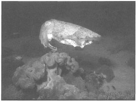
Figure 23.15. Coral reef cuttlefish (Sepia sp.) are overexploited in many parts of the Indonesian Archipeago. These species have high ecotourisem potential, since they are highly curious of divers.
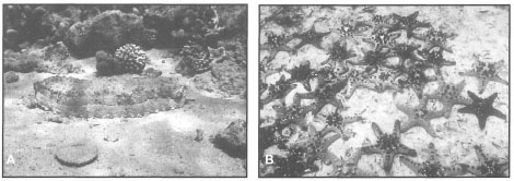
Figure 23.16. A) Sea cucumbers such as Stichopus variegatus constitute an economically important coral reef fishery. Sea cucumber stocks throughout the archipelago are steadily declining as a result of heavy demand. B) In many areas where sea cucumber populations were fished out, populations of the starfish Protoreaster nodosus expanded rapidly.
A) Photo by Tomas and Anmarie Tomascik. B) Photo courtesy of A. Ibrahim, P30-LIPI, Ancol, Jakarta.
GLOBAL CLIMATE CHANGE AND CORAL REEFS
Coastal ecosystems (e.g., coral reefs, mangroves, seagrass beds) have evolved in an ever-changing environment. Coral reefs survived major global climate changes that raised the average global temperatures by a few degrees Celsius, and sea level stands that were either 350 m above or 200 m below present-day sea level. These natural fluctuations, however, occurred relatively gradually and in an environment where human activity was not a factor. The expected sea level rise and global warming will most likely not have a direct impact on Indonesian coral reefs as such, but will have indirect effects through changing weather patterns and oceanic circulation. Rapidly developing new technologies, especially satellite-based remote sensors, will become increasingly important tools in future coral reef assessments and monitoring programs. However, with a few exceptions (e.g., Wilkinson et al. 1993), most model predictions on the effects of global climate change (e.g., temperature or sea level increase) on coral reefs leave out one important environmental factor from the analysis, the human factor.
Sea Level Rise. According to the report of the Intergovernmental Panel on Climate Change (IPCC), it is probable that the global atmospheric levels of CO2 will double by the middle of the next century (Houghton et al. 1990). The general consensus is that the doubling of CO2 levels will result in an increase of global average temperatures by about 0.3°C per decade, with higher latitudes experiencing greater warming when compared to low latitudes of the subtropics and tropics. By the year 2100, it is predicted that the net increase may be as much as 3°C (Houghton et al. 1990). The increase in the average global atmospheric temperature will have a direct impact on sea levels, mainly through thermal expansion of the sea water, as a result of heating (i.e., steric effect). Other factors that will influence the relative sea level rise are related to atmospheric changes in wind patterns, which are closely linked to oceanic circulation. For example, one of the main direct effects of atmospheric-oceanic interactions is related to the piling-up of waters against coastlines under the influence of unidirectional wind fields (Stewart et al. 1990). Changes in local or regional wind and atmospheric pressure fields may have a pronounced effect on sea level fluctuations, especially in enclosed or semi-enclosed seas such as the Java or Arafura Seas that are under strong monsoonal influence.
The rapid meltdown of polar ice caps and the corresponding rise in global "eustatic" sea level has received a lot of media and scientific attention in recent years, mainly as a result of a number of catastrophic predictions (Mercer 1978; Hoffmann et al. 1983; Houghton and Woodell 1989). However, new evidence indicates that rapid meltdown of the Antarctic and Greenland ice sheets is unlikely to be a major factor, since the glaciers will remain too cold to melt (Frolich 1989; Stewart et al. 1990). According to the IPCC report, the expected global "eustatic" sea level rise will be about 6 cm per decade.
Coral Reefs and Rising Sea Level. Of main concern in this discussion is the question of how Indonesian coral reefs will respond to the predicted sea level rise. It should be kept in mind, that since the archipelago is located in a tectonically active region, relative sea level changes are a common occurrence. When we consider the rapid rates of tectonic uplift, evident on many islands in eastern parts of the archipelago (e.g., Timor, Sumba or Alor) (Pirazzoli et al. 1991, 1993; Hantoro et al. 1994; Hantoro 1995; Hantoro and Handayani 1955), it seems unlikely than the predicted sea level rise will have much of an impact on the coral reef in this region.
To answer, at least partially, the above question, we have to determine whether the changes that will accompany the predicted sea level rise will either exceed existing tolerance levels and evolutionary experience of the coral communities, or create a new combination of environmental factors that may be either lethal or sublethal (Buddemeier 1993). As was clearly pointed out by Buddemeier (1993), and in the section on Tertiary history of coral reef development, coral reef communities have survived eons of fluctuating sea levels and global climatic changes. Most extant coral genera date to the Cretaceous and early Tertiary and came through the ice ages (Plio-Pleistocene) with low extinction rates (Buddemeier 1993). It seems logical to presume that coral reef communities reestablish themselves after natural perturbations, otherwise they would not exist. Buddemeier (1993) points out that "…reef corals and reef communities are not merely adapted to the environments in which they occur today; they are also adapted to extensive and repeated climate change, and there is what I will loosely describe as a deterministic element to the robustness and resilience of both taxa and communities with respect to climate change". However, the major uncertainty with regards to the expected global warming is whether this anthropogenically-induced climate change will be different from past natural events. On its own, perhaps not, even considering the rate of temperature increase and sea level rise, since most Indonesian reefs are now limited by sea level, so higher sea level may in fact allow new reef growth. However, this climate change (when it occurs) will be fundamentally different, because the human factor has been added to the function. The synergistic effect of all anthropogenic influences will fundamentally change the impact of the anticipated disturbance. It is probable that the main effect of anthropogenic impacts will be the retardation of recovery (Buddemeier 1993).
Sea level rise by itself may not be a serious problem to coral reefs and other shallow-water marine ecosystems, since the rate of rise is predicted to be within tolerable limits. During the early Holocene transgression sea level rise exceeded predicted future rates by a factor of three for periods in excess of 1000 years (Fairbanks 1989). However, Kayanne (1993) suggested that if present sea level rise exceeds a rate of about 4 m.ka-1 (40 cm per century), then many coral reefs will drown. Calcium carbonate deposition rates of Holocene reefs attained maximum rates 5-6 ka B.P. with-a rate of about 0.45 atmospheric carbon mass units per 1 ka. During the Holocene transgression, Indonesian coral reefs thrived, since it was during this period that the extensive oceanic platforms, that are now sea-level limited in growth, caught up and are now "stuck" in terms of vertical growth even though lateral growth is continuing. Absolute sea levels were significantly higher 125,000 years ago during the Eemian interglacial. Many Pacific reef flats are sea-level limited and/or relics of past Holocene high-stands (Buddemeier et al. 1975). According to Kayanne (1993), many early Holocene reef flats never actually caught up with sea level. As the sea level rise slowed from 4 m.ka-1 to 2 m.ka-1, reef crest facies and algal ridges formed to sea level.
It seems likely that most oceanic reefs in the Indonesian Archipelago may actually benefit from sea level rise. Optimal levels for coral growth span ranges of about 10 m or more, and are subsurface, thus, even with centuries of sea level rise, corals could keep up in many places. The question is whether corals that have been influenced by anthropogenic impacts have maintained the ability to keep up; in other words, are they still growing? Higher sea level will expose huge reef flat areas to new coral (seagrass, mangrove) colonization, however, if these systems have been degraded by human impacts, it is unlikely that significant recolonization will occur. A good example where this may occur is on the numerous heavily developed patch reefs in the Kepulauan Seribu Complex. Extraction of coral colonies from reef flats has degraded numerous patch reefs. The unstable rubble that is now covering many reef flats will inhibit recolonization, and thus it is expected that the island will be exposed to progressively higher levels of wave energies as sea levels continue to rise. Many of the coral cays will disappear, as has occurred in the past (Stoddart 1986).
JAKARTA BAY: THE WAY OF THE FUTURE
Environmental degradation is discussed in general terms with a focus on Jakarta Bay, which contains a chain of coral cays only a few kilometres from Jakarta, a metropolis of about nine million inhabitants. The review of existing literature demonstrates that a strong inverse relationship exists between water transparency, a measure of water quality, and a number of coral community characteristics as well as coral growth rates. Recent studies suggest that natural disturbances (e.g., El Nino) are greatly exacerbated by anthropogenic impacts, which may be the main cause of slow coral community recovery from natural disturbances. The review supports the hypothesis that anthropogenic impacts are the major factor responsible for the demise of scleractinian coral communities in Jakarta Bay.
Among the earliest coral reefs to be studied in Indonesia are those of Jakarta Bay (fig. 23.17). The synthesis of available data suggests that coral reef communities which have evolved in sedimentary depositional environments (e.g., in close proximity to major rivers), while being relatively resilient with respect to natural environmental impacts, are highly sensitive to environmental impacts associated with a wide spectrum of anthropogenic activities.
The strong modifying influence of mainland Java on the 'water quality' of Jakarta Bay and Kepulauan Seribu is reflected in a strong (r2=0.76) inverse relationship between water transparency, as measured by an extinction coefficient k (k = 1.7/D; where 'D' is the Secchi disk depth), and the distance from mainland Java (fig. 23.18). Verwey (1931a) provided some of the earliest information on water transparency in Jakarta Bay through Secchi disk measurements. Figure 23.19 provides a temporal and spatial comparison of Secchi disk depths (m) in Jakarta Bay. The results demonstrate that coral reefs found closer to Java (i.e., Onrus and Kelor) show no difference among the 1929, 1985 and 1993 values, whereas reefs further away from the. mainland show a dramatic reduction in water transparency from 1928 to 1993. The historical data suggest that annual land-runoff events during the West Monsoon (November-March) are the main environmental factor in the development and survival of coral reefs in Jakarta Bay and Kepulauan Seribu.
Review of historical data indicates that Jakarta Bay has become progressively more eutrophic. Table 23.3 presents a comparison of nutrient concentrations in Jakarta Bay and Kepulauan Seribu since 1969. Compared to other parts of the world where eutrophication is a major concern, these nutrient concentrations may be considered as extreme.
High nutrient concentrations in Jakarta Bay and Kepulauan Seribu have been identified as the main cause of increased primary productivity of the surface waters. Chlorophyll-a concentrations measured in Jakarta Bay in 1977 (Setiapermana et al. 1980) ranged from 1.02 to 3.39 mg.m-3, while Nontji (1978) recorded chlorophyll-a concentrations between 5.41 to 12.3 mg.m-3, and suspended particulate matter concentrations in the range of 10 to 79.6 mg.l-1, between 1975 and 1976. Praseno and Andan (1978) documented massive diatom blooms (e.g., mean of 102.24 x 10³ cells.l-1 in January 1977). R. Harger (pers. comm.) has pointed out that phytoplankton blooms are now spreading further offshore. In 1986 massive algal blooms were limited to within 2 km from Tanjuk Priok (Jakarta's port). However, in 1988 the blooms spread out to 5 km offshore, and in 1990 massive algal concentrations were measured 12 km from the port.
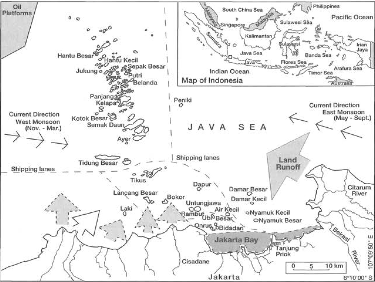
Figure 23.17. Generalized map of Jakarta Bay. Shaded area in Jakarta Bay indicates highly polluted zone. Shaded arrows indicate river runoff.
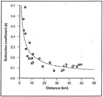
Figure 23.18. The relation ship between extinction coefficient k (k = 1.7/D, where 'D' is the Secchi disk depth in m) and the distance from Java (y = 0.86x-0.58; r2 = 0.76; P<0.0001).
Data from Brown 1986.
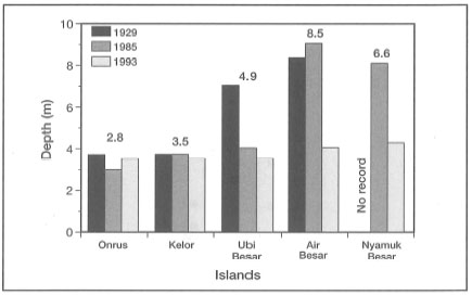
Figure 23.19. Temporal and spatial comparison of Secchi disk depths between five patch reefs in Jakarta Bay. The numbers above the columns indicate distance (km) from Java.
Data from Verwey 1931a and Brown 1986.
Since k is a function of suspended particulate matter concentrations (SPM) in the water column, it is expected that there should be a strong relationship between k and a number of coral community characteristics. Indeed, figure 23.20 and figure 23.21 demonstrate a strong inverse relationship between k and two coral community characteristics, namely the percent coral cover (r2 = 0.58) and the Shannon-Wiener's index of diversity H' (r2 = 0.48).
The re-analysis of historical data also revealed a strong negative relationship between k and coral growth rates in Kepulauan Seribu and Jakarta Bay. Figure 23.22 demonstrates a significant (r2 = 0.27; P<0.02) inverse relationship between water transparency (k) and the growth rates of Poriteslutea. To demonstrate that water transparency is a key environmental factor affecting the vertical distribution of corals as well as the maximum depth of a "functional" coral community, a regression analysis (power function) was performed on the measured maximum depth of functional reef and k The results demonstrate (fig. 23.23) that the maximum depth of a functional coral reef is a strong function (r2= 0.49) of water transparency, and therefore, water quality. The significant reduction in water transparency (fig. 23.19) is paralleled by a dramatic reduction of the maximum depth of a coral community from 1929 to 1993 (fig. 23.24).
Table 23.3. Temporal comparison of average nutrient concentrations (±SD) in the general area of Jakarta Bay from 1964 to 1992. The data are for trend illustration only.
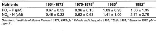

Figure 23.20. Relationship between percent live coral cover and water transparency (k =1.7/D; 'D' is the Secchi disk depth) in Kepulauan Seribu (y = 0.55x-1.62, r2 = 0.58, P<0.0001).
Data from Brown 1986.

Figure 23.21. Relationship between the Shannon-Wiener's index of diversity H\ based on coral abundance, and water transparency (k = 1.7/D; (D' is Secchi disk depth) in Kepulauan Seribu (y = 0.48x-0.43, r2 = 0.48, P<0.0001).
Data from Brown 1986.
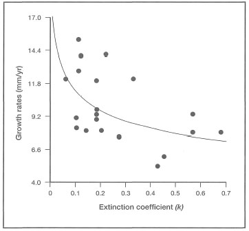
Figure 23.22. Porites lutea. Average yearly skeletal extension rates of P. lutea against water transparency (k= 1.7/D; 'D' is Secchi disk depth) in Kepulauan Seribu (y = 6.64X-0.23, r2= 0.27, P < 0.02).
Data from Scoff in 1986.
The coral reef communities in Jakarta Bay are examples "par excellence" of the terminal stage of anthropogenic impacts. The coral reefs of Jakarta Bay and Kepulauan Seribu evolved and developed in marine depositional environments, and, as such, one would expect them to be well adapted to the seasonal fluxes of land-derived sediments and the associated influx of nutrients. Verwey (1931a) was the first to provide concrete data to demonstrate that there was a strong negative relationship between water transparency and the maximum depth of the living reef. Verwey (1932b) suggested that the reef development in Jakarta Bay is made possible by the combination of sedimentation and hydrologic conditions of the area. The high seasonal variability in water transparency was also reported by Verstappen (1953), who showed that water transparency near Nyamuk Besar ranged from 6 to 12 m during the east monsoon (May-September), and between 4 to 6 m during the west monsoon (November-March). These earlier studies suggest that land-runoff has played a significant, not necessarily detrimental, role in structuring of coral communities in Jakarta Bay.
In 1929 the reefs in the western part of Jakarta Bay were live, "thriving reefs". Umbgrove (1939a) recorded 96 coral species from Nyamuk Besar. Today, only two reefs have 'some' coral colonies. Out of the 96 coral species described, only about 16 species remain and these have very low abundance. Umbgrove (1939a) made a qualitative description of Nyamuk Besar, and at the time, the reef was characterized by a prominent Montipom digitata ("ramosa") and M. foliosa facies. Today, none of these remain! The large moat of Acropora aspera present in 1928 has disappeared as well. Based on historical and current evidence, it is clear that the once "thriving reefs" of Batavia (Jakarta) Bay are functionally dead at the present. Clearly, something other than, or in addition to, the natural turbidity must have played a significant role in their demise. Land runoff has increased to such an extent that the river runoff, with its assortment of industrial, agricultural and urban wastes, now reaches further out to sea.
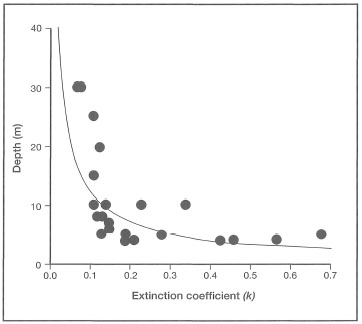
Figure 23.23. The relationship between the maximum depth of a functional coral reef and water transparency as measured by a Secchi disk depth in Kepulauan Seribu (y = 2.08X-0.78, r2=0.49, P< 0.00004).
Data from Brown 1986.
However, pollution and increased land runoff are not the only anthropogenic stresses affecting the reefs in Kepulauan Seribu. Verwey (1931b) observed that rapid abrasion of coral cays in Jakarta Bay was a result of coral extraction for road works and construction in Jakarta. It was estimated that approximately 8500 m of coral was being extracted from the reefs. It should be pointed out that the coral mining, then and now, occurs on the shallow reef flats. Ongkosongo and Sukarno (1986) reported that in 1982 approximately 120 m3 of coral was extracted from the reefs per inhabitant (current population of Kepulauan Seribu is about 7000). Verwey (1931b) estimated that approximately 20,000 m3 was being removed annually from the reefs of Kepulauan Seribu. Recent removal of large quantities of sand and coral rock for the construction of Jakarta's international airport resulted in the demise of two coral cays (i.e., Air Kecil and Ubi Kecil), while Ubi Besar is slowly disappearing (Ongkosongo 1986).
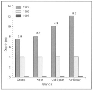
Figure 23.24. Temporal and spatial comparison of maximum depth of living coral reef among four patch reefs in Jakarta Bay. Numbers above columns are distances (km) from Java.
Data from Verwey 1931a and Brown 1986.
This massive assault on the reef infrastructure is reflected in reduced abundance and diversity of corals and coral reef fishes throughout the island chain (see Sukarno 1989). Coral reef fish in Jakarta Bay are in very low abundance, and seem to be almost totally absent from Bidadari, Onrus and Kelor. However, these reefs have an unusual abundance of benthic crabs (e.g., Eriphia smithi, Ategratis integerrimus, Carpilius maculatus and Lophozozymus pictor), indicating a major ecosystem-wide shift. Whether the low abundance of coral reef fish is a direct result of overfishing or the demise of coral communities, or a combination of the two, is an important management question in need of an urgent answer.
The demise of the coral reef communities in Jakarta Bay, and the continuous degradation of reefs in the Kepulauan Seribu, are having a dramatic impact on reef fisheries in Kepulauan Seribu. Figure 23.25 illustrates the dramatic reduction in fisheries landings since 1969. In 1990, the total value of the muro-ami reef fishery in Kepulauan Seribu was estimated at US$90,000 (Dinas Perikanan 1992). This translates to approximately US$450 per fisherman per year. Approximately 80% of the catch consists of Caesio cuning and C. lunaris, both reef-associated fish species. It should also be pointed out that muro-ami, imported from Japan, is one of the most destructive fishing techniques available. The fishermen (usually 20 in a group) swim over the reef and herd reef fish into wide nets by pounding the reef bottom with heavy rocks attached to a line. In the process they basically pulverize the reef bottom and destroy a significant part of the coral community.
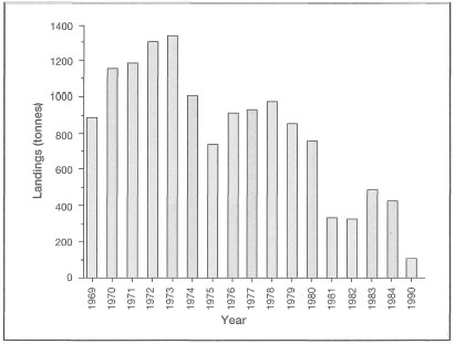
Figure 23.25. The recent history of declining coral reef fish landings from the destructive muro-ami reef fishery in Kepulauan Seribu (total catch per year in tonnes).
Data from: Subani and Wahyono 1987; Dinas Perikanan 1990.
Considering the multimillion-dollar tourism industry in Kepulauan Seribu, which depends heavily on the continued existence of live coral reefs, the destructive muro-ami fishery clearly needs to be reevaluated by the managing agencies of the Kepulauan Seribu Marine National Park. To what degree destructive fishing techniques, such as muro-ami and reef-blasting, have contributed to the demise of coral reefs in Kepulauan Seribu is speculative, but it is clear that these practices cannot continue for much longer.
This review documents a major ecosystem-wide change that has taken place in Jakarta Bay since 1929. In 1929 the living reefs extended down to a depth of 15 m, today none of the coral reefs in Jakarta Bay can be considered as functional coral reef communities, they certainly are no longer able to supply the various resources and amenities they provided 65 years ago. The coral reefs of Jakarta Bay are now functionally dead systems. The animal-algal symbiont associations, characteristic of coral reef ecosystems, have been replaced by a benthic heterotrophic community dominated by filter-feeding and deposit-feeding benthos, characteristic of muddy environments. The reef matrix is now perforated by a great profusion of boring organisms dominated by the bivalve Lithophaga spp. However, boring sponges seem to be rare. Bioerosion, on a massive scale, is currently the main bio-physical process that is contributing to a rapid destruction of the reef matrix. In addition to the boring organisms there is an abundance of benthic molluscs (e.g., Cypraea tigris and Chicoreus ramosus) and stingrays (Taeniura lymma) characteristic of the deeper, muddier parts of the reef slope.
THREATS TO CORAL REEFS AND ASSOCIATED HABITATS
A selected number of development activities which impact directly on the coastal zone are discussed, and specific environmental management guidelines for each development activity are suggested. A brief description of each development activity is provided, followed by a list of potential hazards, impacting activities and, finally, recommended guidelines.
The following is a summary of environmental conditions that are essential for growth, maintenance and repair of coral reef communities as well as for the maintenance of other shallow-water coastal habitats:
· High concentrations of dissolved oxygen in the overlying water column;
· Natural temperature regime - usually warm seawater temperatures not exceeding upper thermal limits of reef-building corals. As a result, coral reefs may be among the most sensitive marine ecosystems to global warming;
· Natural salinity regime - with salinity between 32 psu (i.e., equivalent to parts per thousand) and 36 psu; however, in some areas (e.g., close to large deltas, or in shallow embayments with limited exchange with the sea) corals may be adapted to lower (e.g., 28 psu) or higher (e.g., 42 psu) salinity regimes;
· Natural pH regime - with pH values usually between 8.2 and 8.5;
· High water clarity - wide range of values, but vertical light penetration is usually not less than 10 m as measured by Secchi disk. Optimal conditions (i.e., maximal reef growth) occur at light intensities (i.e., photosynthetically active range), between 30% to 40% of subsurface irradiance (i.e., the irradiance immediately below the water surface);
· Low concentration of inorganic nutrients is an essential requirement for vigorous coral growth;
· Low phytoplankton biomass (i.e., low chlorophyll-a concentrations) with high diversity is characteristic of healthy coral reef ecosystems;
· Low concentration of suspended sediments of terrigenous (originating from land) origin or resuspended marine sediments;
· Low frequency of fresh water land runoff; and
· Water free of pollutants (e.g., agricultural biocides, heavy metals, PCBs, oil and grease, etc.).
Coral Reef Functions
Coral reef ecosystems are critical marine habitats that provide a significant contribution to the functioning of the earth's ecosphere (i.e., the layers of soil, air and water with their organisms). Coral reef ecosystems are significant repositories of marine biodiversity, harbouring a wealth of genetic material, and are considered by many to be the marine analogues of tropical rain forests. Unfortunately, coral reef ecosystems in Indonesia, while very important for food and foreign revenue from tourism and offshore reef-associated fisheries, are not managed and as a result are being rapidly degraded.
Coral reefs in Indonesia will have a critical function in the protection of thousands of coral islands from the effects of the expected sea level rise, which is currently projected at about 6 mm.yr-1. It is essential to emphasize that coral reefs can readily achieve such vertical growth rates under natural conditions. Coral growth rates vary between 2 cm.yr-1, or less, for the boulder-like massive corals, and 20 cm.yr-1 or more for branching corals. However, it is important to note that individual coral colony growth is not the same as coral reef growth, which is a function of both the accretionary (i.e., calcium carbonate production) and destructive (i.e., mechanical erosion, dissolution and bioerosion) forces on the reef. It is projected that if the sea level rise reaches or exceeds 8 mm.yr-1, there may be large-scale and prolific recolonization of present-day reef flats (i.e., area of coral reef that consists mainly of a pavement cemented by calcareous algae) that will increase the current global reef production of- 900 million tonnes of CaCO3 a year to 1800 million tonnes. However, recolonization will ultimately depend on the existence of healthy coral reefs.
The following summary of coral reef functions highlights the necessity to protect coral reef ecosystems from negative anthropogenic impacts:
· Coral reefs are among the most complex and productive shallow-water tropical marine ecosystems.
· Coral reef ecosystems have an important functional role in global biogeochemical cycles.
· Coral reefs serve as breeding, spawning, nursery, feeding and foraging habitats for a great variety of marine organisms, many of which are of economic importance.
· Coral reefs are a storehouse of marine biodiversity and home to a great variety of marine life in the seas.
· Coral reefs protect coastlines and other coastal ecosystems from severe wave action and the full impact of storms, monsoons and tidal waves by acting as self-repairing breakwaters.
· Coral reefs surrounding many tropical islands (especially coral reef islands and atolls) are the main source of sand for beaches and dunes that support complex ecosystems.
· Coral reefs are a source of many varieties of subsistence foods and raw materials.
· In many parts of Indonesia coral reefs serve as the fall-back life support systems in times of agricultural crisis.
· Coral reefs are an important source of bioactive substances used for medical and pharmaceutical purposes.
· Coral reefs are natural recorders of past climate and environmental variation.
· Coral reefs provide recreational opportunities.
· Coral reefs provide educational and research opportunities.
· Coral Reef Users
· Traditional fishermen;
· Subsistence gatherers: reef molluscs, octopuses, sea urchins, shrimps, sea weeds, etc.;
· Fishermen/mariculture: seaweeds, fish; molluscs, sea cucumbers, etc.;
· Commercial fishermen: domestic and foreign; Lime producers;
· Tile makers;
· Sand mining: cement mixes and fill materials;
· Construction companies: housing, roads, harbours, airports;
· Jewelry and decoration makers;
· Coral/shell wholesale dealers;
· Curio traders;
· Coral/shell souvenir shops;
· Coral/shell collectors; Restaurants;
· Fish/coral collectors: marine aquarium trade;
· Tourism trade: airlines, tour operators, hotel/resort operators, gourmet food, dive club operators, boat operators, tour guides, small home-stays.
CORAL REEF USES
In terms of economic development, coral reefs provide for a number of sustainable and non-sustainable development activities.
Sustainable
Offshore Fisheries. Many offshore fisheries (e.g., Scombridae - tunas and mackerels; Exocoetidae - flyingfish; Carangidae - travallies, jacks, scads, runners and pilot fishes; Carcharinidae - requiem sharks, etc.) are dependent on a functional coral reef system for support, either as breeding, nursery or feeding grounds.
Reef Fisheries. Coral reefs support important local reef fisheries based directly on the reef. The four dominant fisheries are:
i) Finfish fisheries: e.g., Muraenidae - moray eels; Holocentridae - squirrelfishes, soldierfishes; Serranidae - groupers, sea basses, rock cods; Lutjanidae - snappers, sea perches, etc.;
ii) Invertebrate fisheries: e.g., Gastropods -Trochus; Bivalves -Tridacna, oysters, mussels; Crustaceans - shrimps, lobsters, crabs; Cephalopods - octopuses, squids, cuttlefish; Echinoderms - sea cucumbers, sea urchins; Coelenterates -jellyfish and anemones;
iii) Marine reptile fisheries such as sea snakes and sea turtles; and
iv) Marine algae (i.e., seaweeds) and seagrasses.
It has been reported that a healthy coral reef may produce anywhere between 25 to 45 metric tonnes of fish per square kilometre each year. In contrast, a degraded coral reef may produce between two and five metric tonnes, and a functionally dead coral reef will not sustain any reef fishery.
There are no data available to estimate the economic contribution or value of coral reefs to offshore fisheries. However, foreign currency earned by tuna fisheries (which may have a strong dependence on coral reefs) in east Indonesia contribute significantly to the national economy. In west Lombok, which has a coral reef area of about 10,000 ha, realized coral reef fish landings were approximately 0.298 tonnes per ha (Riopelle 1995). Thus the value of 1 m2 of coral reef in west Lombok is US$0.58 to 1.00, depending on the discount rate (Riopelle 1995). It is expected that as tourism continues to grow in Indonesia so will the value of coral reefs, especially in popular diving destinations such as Bunaken and Banda.
Coastal Protection. Coral reefs are self-maintaining and -repairing breakwaters, protecting beaches and beach properties from wave erosion and storm surges.
· Fringing reefs and atolls provide calm waterways and lagoons in which a number of human activities (e.g., collection of invertebrates and seaweeds, fishing, transportation between islands) takes place, protected from the surf or storm waves.
· Coral reefs are important sources of coral sand that maintain beaches and islands.
Marine Tourism. Tourism - sun-, sea- and sand-oriented. Snorkeling and scuba diving are primary attractions in many tropical islands.
Mariculture. Coral reefs, reef flats and associated lagoons provide a great potential for aquaculture (e.g., giant clams, pearl oysters, trochus shell, seaweed, etc.).
Biotechnology. Coral reefs provide a wide range of products for pharmaceutical and medical purposes.
Aquarium Trade. Coral reefs may support valuable aquarium trade industries with appropriate management techniques.
Refuge Areas. Coral reefs provide habitats for rare and endangered species.
Coral Sand Mining. Coral reefs are depositories of sand that can be used sustainably on a limited basis with appropriate technology and management. Coral sand is a valuable pH buffer and a filtration material in the marine aquarium trade.
Souvenir Manufacture. Small-scale collection of corals and other reef invertebrates may be a sustainable industry, provided that appropriate management and conservation techniques are applied.
Research and Education. Coral reefs are open laboratories for research and education.
Non-Sustainable Uses
Extractive Activities. Large-scale coral and sand extraction for: 1) lime production; 2) building blocks; 3) other construction materials; and 4) hard armour stone for shoreline protective structures.
Destructive Fisheries. Fisheries using inappropriate fishing techniques such as dynamiting.
Collection of Reef Organisms. Large-scale collection of corals and shells for jewelry and other uses with inappropriate collecting techniques.
Aquarium Trade. Large-scale collection of reef fish and reef invertebrates for the aquarium trade with inappropriate collecting techniques such as the use of cyanide.
Development. Opportunities for landfill expansion and construction activities on reefs.
ENVIRONMENTAL IMPACTS
1) Oil pollution from offshore oil platforms and oil tankers.
· Oil pollution causes general biological degradation in corals and other reef organisms;
· Petroleum hydrocarbons (PHC) are detrimental to coral growth, reproduction, colonizing capacities, feeding and behavioural responses.
2) Sedimentation from dredging, filling, and coastal construction activities.
· Excessive sedimentation may adversely affect the structure and function of coral reef communities through alteration of physical, chemical and biological processes;
· Sedimentation increases turbidity of the water column, which reduces light penetration and zooxanthellae photosynthesis, thus directly affecting net productivity of corals;
· Sedimentation causes direct physical smothering of corals and other benthic reef organisms;
· High sedimentation is associated with low live coral cover, reduced coral recruitment and lower reef growth;
· Sedimentation reduces coral growth and reproduction.
3) Sedimentation from the discharge of mine tailings from coastal mining operations.
· Produces direct toxic effects;
· Causes increased turbidity, which reduces zooxanthellae photosynthesis;
· Causes direct smothering of benthic organisms.
4) Upland soil erosion from agriculture, deforestation, roads, and urban and industrial construction.
· Results in increased turbidity and sedimentation;
· Introduction of pesticides and other biocides;
· Introduction of nutrients.
5) Discharge of industrial wastes, including effluents from desalination plants.
· Causes general biological degradation through introduction of biocides and other toxins;
· Alteration of natural environmental conditions.
6) Sewage discharge.
· Causes eutrophication through excessive nutrient loading;
· Interferes and alters natural ecological processes on coral reefs;
· Chlorinated sewage effluents may subject marine biota to either single-event acute exposures or to chronic (i.e., continuous) exposures;
· Chlorine in sewage may either produce acute toxicity or chronic toxicity.
7) Discharge from fish and agricultural processing.
· Promotes eutrophication;
· Introduction of sediments and biocides;
· Introduction of pests and disease organisms.
8) Thermal effluents from electrical generating stations and other industries.
· Causes general biological degradation;
· Alters and interferes with basic physiological processes.
9) Destructive fishery practices such as dynamiting, trawling over reefs, muro-ami, use of chemicals/poisons and over-fishing.
· General habitat destruction;
· Species and stock depletion.
10) Collection of corals and shells for the tourism industry at rates beyond sustainable levels.
· General habitat destruction and change in ecosystem balance.
11) Collection of aquarium reef fishes using poisons and other inappropriate collecting techniques.
· General habitat destruction and changes in ecosystem balance.
12) The use of explosives for activities other than fishing.
· General habitat destruction;
· Stock and species depletion.
13) Recreational impacts from anchor damage, scuba diving, snorkelling, boating.
· General habitat destruction.
14) Construction activities on reefs (e.g., jetty construction).
· Habitat destruction.
15) Release of toxic chemicals from land and ships.
· Habitat destruction and changes in the ecosystem balance.
16) Marine sediment mobilization (resuspension) by deep-draft ocean-going vessels.
· Habitat destruction;
· Change in ecological balance.
17) Release of radioactive waste.
· Contamination of various trophic levels;
· Direct physiological and genetic damage to coral reef organisms.
18) Dumping of solid wastes (e.g., becaks, plastic bags, etc.).
· Habitat destruction and changes in ecological balance.
19) Coral mining and sand collecting.
· Habitat destruction;
· Change in ecological balance;
· Stock and species depletion.
20) Shading by marine structures (e.g., pontoons, multistorey structures, rafts, etc.).
· Reduces photosynthesis of zooxanthellae and other primary producers;
· Change in ecological balance.
21) Discharge of fresh water.
· Causes habitat destruction and death of reef organisms or severe physiological stress.
22) Discharge of ballast water.
· Direct toxic effects and introduction of pest organisms.
MARINE TOURISM
This section provides an example of a specific development activity that has a potential to significantly alter the characteristics of coastal areas, and therefore, to have a direct and indirect impact upon coral reef ecosystems. It needs to be stressed that treatment of all development activities that may have an impact on the coastal zone is beyond the scope of this book.
Considering the fact that land-based pollution is the primary cause of coral reef decline worldwide, it is important to stress that under no circumstances should a coral reef area be considered as a zone of mixing for industrial or other effluents. A zone of mixing can be defined as an area where allowance is made for the mixing of wastes with the receiving body of water, and where water quality criteria (or standards) do not apply, provided no recognized beneficial use is significantly threatened.
Marine tourism in Indonesia is growing rapidly, even though the capacity to control its impacts has not yet been addressed. The attractions of clear tropical waters, white coral beaches, and the popularity of scuba diving is attracting increasing numbers of foreign and local tourists to coral reef ecosystems. The hazards to coral reefs from marine tourism are not only associated with direct human interference with sensitive biota, but include those activities associated with construction and land development. Tourism has been implicated in the degradation of many reef areas, particularly in Southeast Asia.
Tourism development on coral cays and its impact on the surrounding coral reefs is becoming a serious problem. It is essential to recognize that coral cays, which are made of reef-derived material, are very dynamic morphological features, changing with every tide. The morphology of the island can change rapidly and unpredictably. Unfortunately, in all instances this natural change in coastline morphology is perceived by all developers and management officials as coastal erosion. To prevent this natural process, the developers have destroyed large parts of the reef surrounding the islands by removing coral from the reef flats for shoreline protection. This activity not only destroys the reef itself, which is what initially attracts the tourists, but also accelerates the beach erosion processes. As a result, more money is needed to build ever larger and costlier beach protection structures. Eventually, the man-made modifications to the coastal morphology become so great that the coastal current patterns are changed to such a degree that major shifts in the benthic communities occur.
Hazards
· Direct physical damage to the coral reef and adjacent coastline through construction activities and coral collections for construction.
· Increased influx of sediments from land-based operations.
· Increased influx of sediments from marine operations.
· Increased influx of fresh water runoff, nutrients and other pollutants from cleared land, parking lots, golf courses, roads, airports, etc.
· Introduction of toxic chemicals.
· Increased nutrient loading from sewage waste.
· Introduction of pollutants such as gas, oil, boat exhausts, antifouling compounds, pesticides, etc.
· Introduction of oils and grease from bathing activities (i.e., suntan and moisturizing lotions) in areas with restricted circulation patterns.
· Alteration of circulation patterns as a result of coastal engineering works (i.e., reef-blasting, dredging, marinas, breakwaters, etc.).
· Collection of corals and shells as souvenirs.
· Direct physical destruction through recreational activities such as reef-walking and boat anchoring.
Impacting Activities
Construction.
· Immediate physical impacts through extraction and trampling;
· Increased sedimentation associated with land clearing, road construction, parking lots, airport construction, etc.;
· Alteration of coastal current patterns as a result of jetty, breakwater and marina construction.
Resort-Hotel-Marina Operations.
· Introduction of TBTO (tri-butyl tin oxide) antifouling agents;
· Sewage discharge near or up-current of coral reef areas;
· Increased load of solid waste and problems with disposal;
· Nutrient runoff from golf courses that use excessive amounts of fertilizers;
· Building encroachment on beaches may cause severe beach erosion;
· Increase in solid wastes;
· Increased freshwater runoff created by the buildings, recreational facilities and infrastructure facilities (i.e., increase in surface area due to roofs, parking lots, new roads, tennis courts, etc., and removal of vegetation);
· Release of pollutants such as gas and oil from marine supply sources and from operating boats;
· Resuspension of sediments by boat traffic;
· Disruption of longshore sand movement and beach replenishment;
· Increase in copper concentrations from boat antifouling paints;
· Increased turbidity and release of nutrients and toxic compounds during dredging and subsequent maintenance.
Toxic Waste Discharges.
· Discharge of chlorinated swimming pool water (i.e., fresh water) from beach hotels, resorts and/or private housing units into the coastal waters;
· Chlorinated swimming pool water contains toxic compounds that are formed through exposure to sunlight.
Anchor Damage.
· Physical destruction of corals and other marine organisms (fig. 23.26);
· Increased production of rubble and fine sediments that become available for resuspension, thus affecting water clarity, coral recolonization, and coral health in general.
Figure 23.26. Anchor damage to reefs is a serious problem on many reefs.
Photo courtesy of A. Ibrahim, P30-LIPI, Jakarta.
Diver Damage.
· Direct physical damage through breakage and indirect damage through sediment resuspension.
Small Boat Damage.
· Boat groundings at low tide cause direct physical damage to the reef substrate as well as direct kills of corals.
Reef Walking.
· Direct physical damage to corals and other benthic organisms.
Boulder Moving.
· Overturning boulders by reef-walkers and fishermen results in direct physical damage to the reef;
· Overturning of boulders and other substrates exposes many "shade-loving" benthic organisms to direct sunlight and may cause tissue damage and/or death;
· Changes in substrate morphology, as a result of physical damage, will cause changes in community structure.
Collections.
· Continuous collection of shells and coral colonies from the reef is not a sustainable activity;
· Continuous collections of reef organisms from specific areas of the reef will alter the community structure.
Guidelines
· Proceed with marine and coastal tourism development within the framework of national, regional, and local socioeconomic development plans.
· Implement specific zoning plans which take into account the natural geographic and socioeconomic conditions of the area.
· Control site clearing, during construction, to minimize impacts on coastal ecosystems.
· Build all structures a good distance from the beach to ensure minimal impact on the beach and adjacent reefs; all land-based structures should be at least 25 m from the shore.
· Install a sewage disposal system that will meet the needs of the operation without endangering the coastal ecosystems.
· Do not discharge liquid and/or solid wastes onto coral reefs and associated coastal communities.
· Discharge of chlorinated swimming pool water (i.e., fresh water) from beach hotels, resorts and/or private housing units into the coastal waters should be directed down-current and away from coral reef areas, or preferably discharged on land.
· Promote other activities in the area other than tourism to avoid mono-economy.
· Install a permanent mooring buoy at all mooring and dive sites.
· Provide educational materials to staff and visitors concerning conservation of coral reefs and other natural ecosystems that are used as tourist attractions.
· Plan all resort, hotel, and marina developments to minimize the risk of water pollution.
· All development activities should be in coastal areas with good flushing rates.
· Access channels to resorts, hotels and marinas should be designed to maximize circulation and avoid stagnation.
· Efforts must be made to use phosphate-free detergents.
· All hotel, resort and marina facilities must have appropriate handling of sewage, refuse and wastes.
· All boats with TBTO (tri-butyl tin oxide) antifouling compounds should be banned.
· Minimize as much as possible the alteration of existing shoreline characteristics, and avoid degradation and/or destruction of critical coastal habitats.
· Tourism development projects should be sited to minimize the need for excavation, shoreline alteration, and disturbance of critical coastal habitats.
· Prohibit the use of TBTO (tri-butyl tin oxide) antifouling compounds in all marinas in close vicinity to coral reefs.
· Use sediment curtains in all earthworks.
· Restrict earthworks to slack water conditions.
Box 23.2. The coral reefs of West Sumatra.
Andreas Kunzmann, Coral Reef Assessment and Monitoring Project (CRAMP), Bung Hatta University, Jl. Sumatera Ulak Karang, Padang 25114, Indonesia.
Introduction
Padang, the capital of West Sumatra Province, is located at 01° S and 100° E. The coastline of West Sumatra extends from Air Bangis (north) to Mukomuko (south) for a length of about 450 km (fig. 23.27). The provincial waters include the Mentawai Islands (Pulau Siberut, Sipura and Pagai), located about 167 km to the west. The surface area of the sea comprises about 20,000 km2, or about 50% of the total provincial area. The Exclusive Economic Zone (EEC) amounts to more than 140,000 km2 (data from Dirjen 1993; BAPPEDA 1993; and Kunzmann and Efendi 1994). Altogether about 297 islands and reefs (shallower than 20 m depth) are mentioned on the hydrographic charts of West Sumatra. However, West Sumatra only represents about 0.6% of Indonesian territorial waters. With less than 100 islands, West Sumatra also represents only about 0.6% of the 17,508 islands in Indonesia. Only seven islands in the province are larger than 343 km2. From north to south these islands are Pini, Tanahmasa, Tanahbala, Siberut, Sipura, Pagai Utara and Pagai Selatan.
Fish Landings and Economy
The total fish landings of West Sumatra in 1993 amounted to 66,000 tonnes with a value of about Rp 8.8 x 10¹⁰. The fishing industry supports about 6000 fishermen. In the vicinity of the provincial capital, Padang, catches and fishermen total 50,000 tonnes and 2500 people, respectively (Dinas Perikanan 1994). The share of catch from coral reefs is underrepresented and amounts to only 5000 tonnes. The fishes and fishing methods, which are by far dominant in terms of volume, value and labour involved, are anchovies (ten), which are caught in liftnets with lights (bagans), and small tuna (tongkof), which are caught by gillnets and hook and line. Subsistence fishing, which could increase total landings by at least 50%, is not included in official figures. It is estimated that the number of people relying directly on marine fisheries is 30,000 to 36,000.
Meteorological and Oceanographical Data
West Sumatra, due to its position on the equator, is free from hurricanes and cyclones. Also, the monsoon influence is less dramatic as compared to Java or Kalimantan. Wind and waves from the northwest and west prevail from November through May, and from July through October winds are mainly from the southeast. On the Beaufort wind scale, winds are usually 4-5 Bft, occasionally 6-7 Bft, and even more rarely may reach 8 or 9 Bft (DHI 1990). In the last 20 years there is no record of storms exceeding 9 Bft and only one record, from April 1985, reports two days wind with 9 Bft (BMG 1994). The average surface water temperatures range from 28°C in December to 30°C in May. The salinity and density values are very stable throughout the year, with 33-34 psu and 1020-1021 kg.m-3 (DHI 1990) for most of the area. According to umbgrove (1931), the sea level around Padang has sunk, or the land has risen, 3 to 5 metres, judging from sea level marks in the rocks. It appears that the entire Sunda volcanic arc, including Padang, has been subsiding since the last interglacial high sea level period. This subsiding is masked by a slight mid-Holocene emergence (Hantoro and Naryanto 1992), which is in line with umbrove's findings.
Islands and Reefs of Padang
There are about 86 islands and reefs within 56 km of Padang (fig. 23.28). In general, we find very few fringing reefs along the main shoreline. Most reefs, 1 to 26 km offshore, are breaking or submerged patch reefs, or fringing reefs surrounding high islands.
To the north of the Arau River, we find a flat coast with sandy beaches and alluvial soil, mostly flanked by wetlands/swamps. In this area the distance between the shore and the trans-Sumatra mountain chain, Bukit Barisan, is one or more kilometres. Consequently, all reefs and islands along the north coast are coral cays. There is no documentation whether cores of the islands are volcanic or entirely made by corals. Umbgrove (1931) mentions cores from two coral islands close to Padang, where one is definitely built on a foundation of volcanic rock, whereas the second rests entirely on the muddy bottom of the bay, as is the case with the Kepulauan Seribu in Jakarta Bay and the Spermonde Archipelago.
To the south of the Arau River, the mountains line the coast and volcanic rock prevails both on the coastal shore as well as on many island shores. Frequently the volcanic rock on these islands protrudes through the thin soil cover. Only a few corals grow on this volcanic rock, but we do find barnacles, snails and soft corals.
Apart from this separation into a northern and southern island/reef community, we find two chains of islands/reefs paralleling the coast of West Sumatra at distances of about 13 km and 22 km, respectively. The inshore chain is situated on the continental shelf with depths of no more than 50-70 m around the reefs. The outer chain is west of the 200 m isobath, right on the continental slope, where the islandsreefs are surrounded by deep water with a maximum depth of 2000 m (e.g., Mentawai Basin). Therefore, depths on western and southern reef slopes can easily reach 50 m and more.
The outer chain of islands and reefs parallels the coast from roughly west of Air Haji (2° S) up to Tiku (0°20' S; fig. 23.27), where the shelf broadens and extends out west towards the Batu Islands. Here the chain follows the 200 m isobath, heading away from the coast with a submerged patch reef located every 6-9 km. The entire length of the 'barrier reef system' is close to 278 km.
Most of the islands have a kidney shape or are slightly elongated (i.e., north to south) in response to the prevailing west and northwest wind and wave action. The average island size is about 20 ha, with a circumference of 1500-2000 m. Most islands are encircled by rather steep, coral-covered slopes, thus at a distance of 50 m from the shoreline, we find depths of 30 m and more. The majority of islands are vegetated, mainly by coconuts and alang grass, with some hosting trees and bushes. The northern islands are flat and sandy, while the southern islands are frequently high, with more vegetation and some lined by a few mangrove bushes (Parsumpahan, Cubadak). There are no atolls or lagoons.
The reefs on the west (i.e., weather) side of these islands, and partly along the north and south sides, are roughly 50 m wide. The reefs extend from the lower tide level to depths of 6-9 m. At a few islands the reef flat is up to 100 m wide. Spurs-and-grooves are well developed, and although waves enter with full force, rather fragile branching corals such as Acropora formosa and A. nobilis, or foliose species of Montipora, are present (fig. 23.29). From a depth of 6-10 m, a steep reef slope descends down to depths of 30-40 m. Octocorals and gorgonians are fairly common, with some as large as 3 m. From a depth of about 40 m, a more gentle slope, usually covered with rubble, sand, larger fragments and the occasional coral colony, continues down to 60-80 m.
The southern reefs can be exposed to strong winds for three months or more, each year. No generalization on the reef type is possible, but here are found the only real dropoffs from about 10 m depth down to 40 m with giant gorgonians (4 m and more in diameter; Pieh, G. Pieh - East, G. Air [G. = Gosong, submerged reef; islands are named here without the preceeding P. = Pulau]). Especially in the south of the outer islands can be found a second steep slope starting at about 45-50 m, leading down to several hundred metres (e.g., Pieh, Pandan).
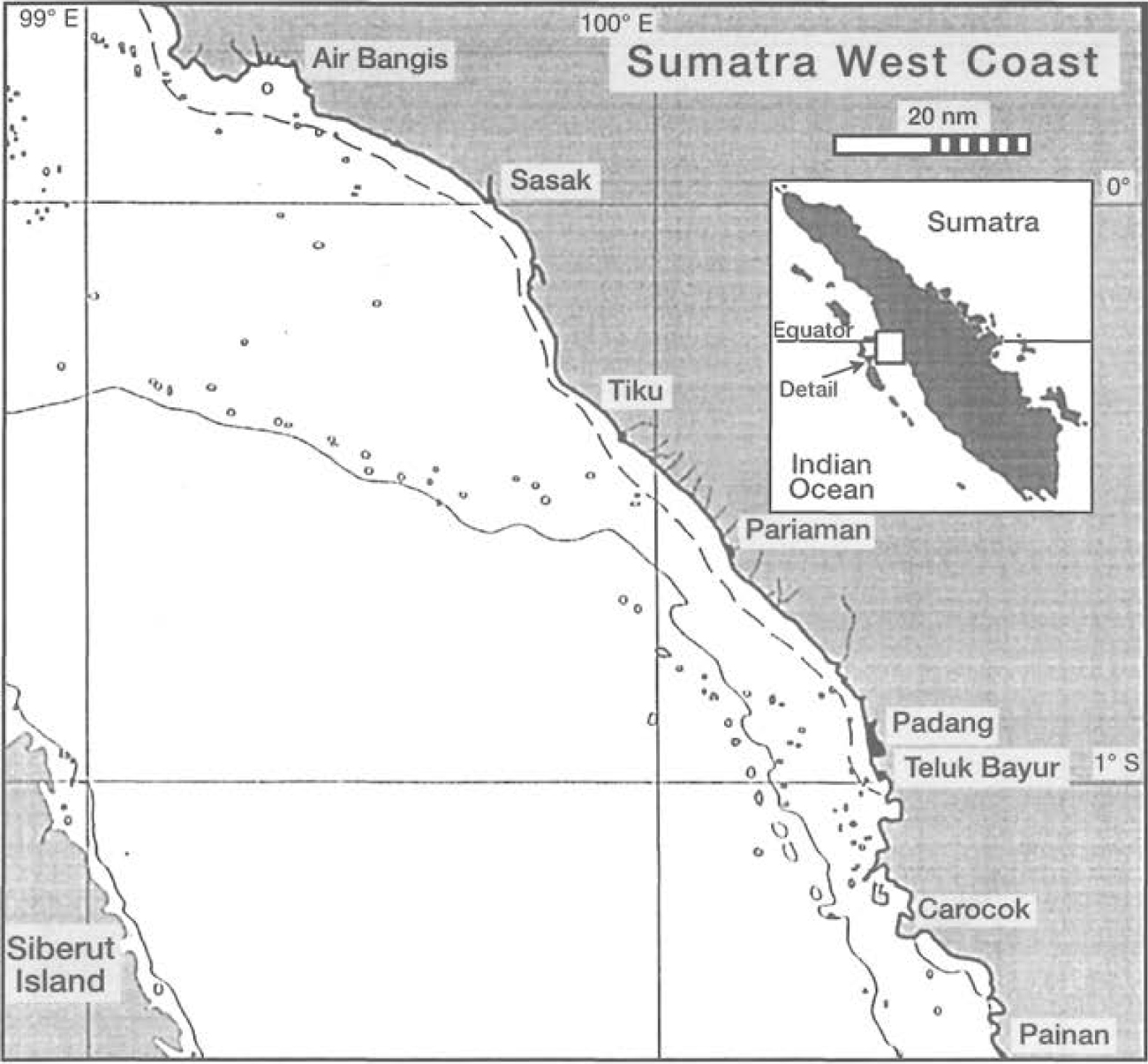
Figure 23.27. Map of the northern coastal area of West Sumatra with depth contours for 20 m and 200 m, respectively (grey = islands and land; white circles = reefs).
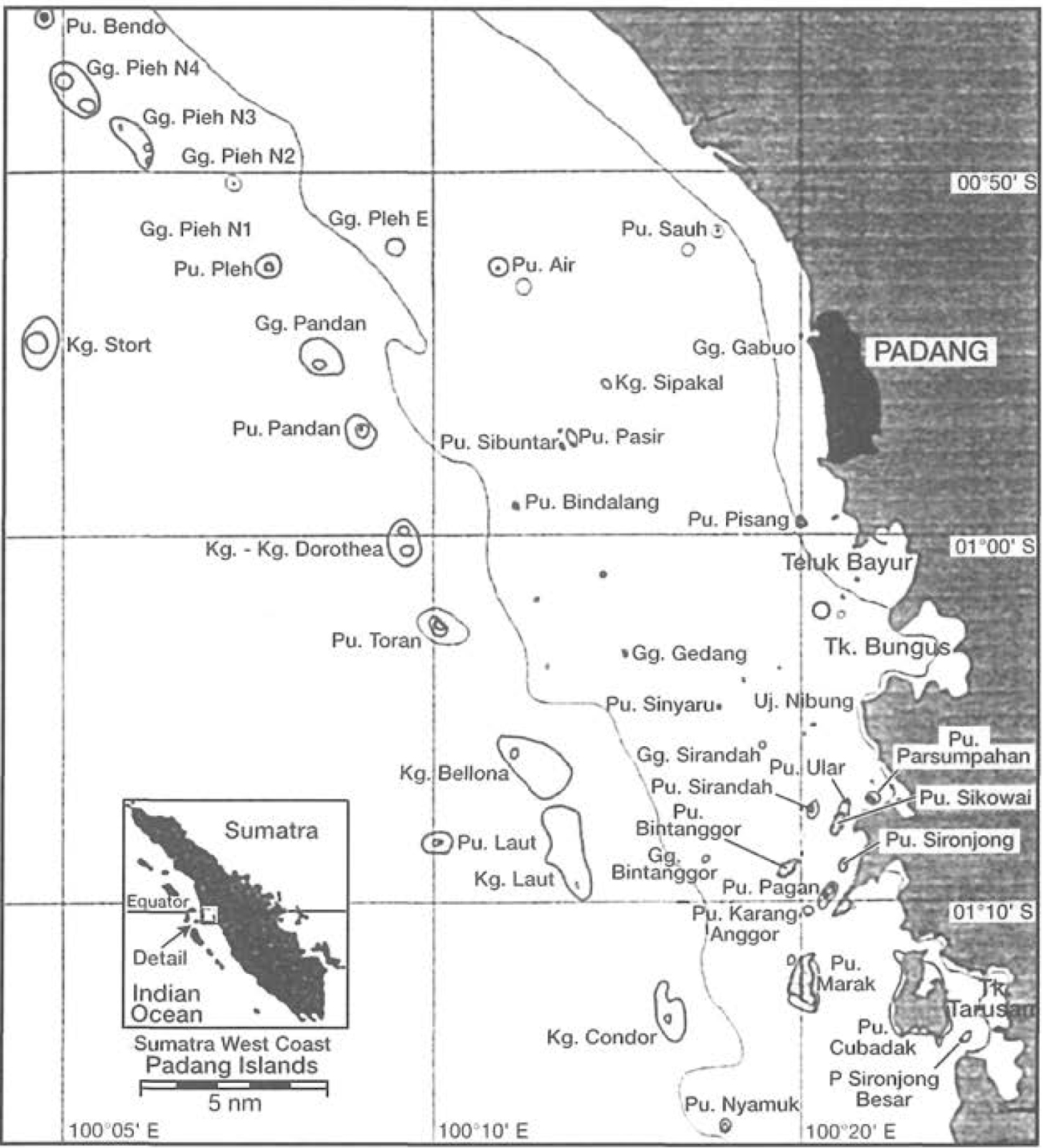
Figure 23.28. Islands and reefs in the vicinity of Padang (Pu. = Pulau = island; Gg. = Gosong = reef). Named reefs indicate research locations up to September 1995.
Figure 23.29. Reef section of Pieh Island, western reef crest, 8 m depth.
Photo by A. Kunzmann.
The eastern sides of the islands are the leeward sides. In these relatively protected environments, reefs are dominated by single big colonies of Poritesand/or Diploastrea,down to 10 m or more (e.g., Pieh, Saoh, Karsik-Pariaman and Ujung-Tiku). More diverse communities are found at depths of 10 m or more. These reefs are subjected to heavy sedimentation, originating from erosion of the island itself as well as from the rivers. On the east side we sometimes find small natural harbours, or channel-like entrances, for safe anchorage.
The inner islands have similar coral communities, but, apart from a few exceptions (e.g., Ular), gorgonians are absent. These reefs are heavily influenced by river sediments. After heavy rainfalls, sediment plumes also reach the outer islands. The brownish sediment plume can be seen as far as 5.5 km off the coast.
Human Pressure on the Reefs
Pollution and Sedimentation
Padang has a population of about 700,000. All households and settlements discharge their waste into the sea, either directly or via three main rivers. There is no waste treatment plant for household or industrial wastes. The rivers and the sea are still used for the disposal of domestic and industrial wastes. Hundreds of neatly packed plastic bags, full of waste, can be seen floating down the river into the sea, eventually littering the beaches. Recently we discovered a fully packed waste bag in the middle of a reef, 15 km from the beach!
Commercial ports and fishing harbours are additional sources of pollution (e.g., Teluk Bayur and Bungus Bay, respectively). Located in Bungus Bay are a plywood factory and an oil pier whose negative impact on corals was demonstrated by Nusyirwan (1994).
Logging and mining activities in the mountains, and intensive agriculture, fill the rivers with eroded soil, fertilizer and heavy metals. The sediment and pollution loads of most West Sumatra rivers are discharged into the Indian Ocean. Depending on the prevailing wind and wave directions, the brownish river runoff concentrates in a 6-km-wide stretch along the coast, usually in a southerly direction, but in rare cases, in a northerly direction as well. The islands/reefs most influenced by river sediments are from north to south: Air Bangis, Tiku and Pariaman Islands, Saoh, G. Saoh, G. Gabuo, Pisang, G. Marlbro, Ular, Sikowai, Sironjong, Pagang, Painan Islands, Batang Kapas Islands and the Kambang reefs. At G. Gabuo, Pisang and Ular, the sediment layer can reach more than one metre. At these reefs, corals with long polyps, like Euphyllia spp. and Goniopora spp., can be seen trying to reach the surface of the mud by sticking the polyps through, whereas other species have died off and are completely covered by mud.
Coral and Shell Mining
Due to the highly productive cement factory of Padang and the availability of boulders and gravel from several rivers, there is no large-scale coral mining for construction purposes. However, over time, coral- and shell-collecting, even though on a relatively small scale, have accumulated impressive figures. According to Syarif (1994), residents of five islands are involved in shell-collecting activities. These islands, within 6 km of the coast, are Pisang, Parsumpahan, Sirandah, Sinyaru and Sikowai. Shells and corals are sold to tourists and locals for ornamental purposes in house walls and aquaria or simply as souvenirs. Branching or brain-shaped corals sold most frequently are Acropora spp., Pocillopora spp. and small Porites and Fungiidae. This activity extracts roughly 10-24 tonnes of shells and coral from the reefs per year, and involves about 10 people collecting once or twice a week (Syarif 1994). Apart from corals, fishermen also collect sea cucumbers and giant clams.
The erosion of heavily mined coral reefs can be witnessed at Pulau Laut, which has been locally renamed 'Gosong (submerged reef) Laut', because it only surfaces during low tide. In sea charts based on Dutch nautical measurements, it is clearly marked as an island. Large-scale movement of sand along the coastline can be seen every rainy season from the campus of Bung Hatta University.
Destructive Fishing
Around 6000 fishermen, with about 2500 fishermen from Padang alone, are operating in the coastal waters with mainly small-scale and medium-scale gear (Dinas Perikanan 1994). Moreover, foreign fishing fleets and countless fishermen from North Sumatra, some still illegally using trawls, poison and explosives, place a heavy pressure on marine life.
West Sumatra fishermen also use explosives and poison (Kunzmann et al. 1993), and when local and national newspapers published several articles, based on research and observations by our research team, the provincial government was moved to reissue a decree, which states that fishing with explosives and poison is illegal (Governor Decree 1993), citing the relevant presidential decrees from 1980, 1982 and 1985.
However, there still are illegal fishing activities on three levels:
i) Small-scale fishermen operate with outrigger canoes and use self-constructed bombs made from old batteries and fertilizer in order to catch fish by blowing up small reef areas. Also, outriggers use small compressors to supply air to divers who catch groupers, snappers and rock-lobsters by use of poisons, which also kill corals.
ii) Medium-scale illegal blasting with big bombs, destroying vast areas of reefs. Two large, two-storey ships, equipped with radio, rubber dinghies, and sizable crews, have been spotted several times.
iii) Large-scale operators with official licenses.
Large ASEAN and Southeast Asian fishing vessels have licenses to catch tuna and sharks offshore in the EEC - however, they also come to the Mentawai Islands, enter territorial waters and each year systematically bomb large areas during the 'ekor kuning' season (Caesionidae).
On Siberut in Teluk Sarabua, live groupers and wrasses are sold to foreign vessels, arriving once a month. Many of these groupers are caught with potassium-cyanide, killing corals in the process.
In Bungus Bay aquarium, fishes were exported on a large scale. These fish were gathered by using large amounts of potassium cyanide. Fortunately, this business was stopped in early 1995 and about 75 kg of potassium cyanide were seized.
All three examples are operators with valid licenses issued by the government. However, monitoring of fishing practices, and enforcement of existing regulations, is hampered by the large areas involved, the lack of personnel, budgetary constraints and the difficulties in coordinating all the departments, police and military units which share the responsibilities.
Current Condition of the Coral Reefs
As a result of the above-mentioned natural and human activities, the coral reefs of Padang are in poor condition. The Research Center for Fisheries Development at Bung Hatta University has been carrying out research on coral reefs and mangroves since early 1993 (Zimmermann and Kunzmann 1994), and in early 1995 the Coral Reef Assessment and Monitoring Project (CRAMP) was launched.
The results indicate that about 74% of all investigated locations are seriously damaged (percentage cover with live coral; PC = 0% - 24%), about 22% of the locations are moderately damaged (PC = 25% - 49%) and only 3.7% of the locations are in good or very good condition (classification according to Sukarno 1993). Only very few islands or reefs have larger reef areas with a PC of more than 70% (Kunzmann and Efendie 1994; table 23.4).
Some locations, although close to a river mouth or a harbour, show a comparatively high percentage cover. Also, the coral species diversity is high and the individual colony size is above average, the investigated locations can be grouped into three categories, such as:
i) islands/reefs with less than 13 km distance to the coast, where visibility is low, the percentage cover, coral species diversity and individual colony size are comparatively high.
ii) islands/reefs at a distance of 13 to 27 km from the coast, where visibility is already good, the percentage cover, however, is low, the species diversity low to moderate and the individual colonies have moderate sizes.
iii) islands/reefs at more than 27 km distance to the coast, where visibility is excellent, but most locations have only very few hard corals with some places being totally destroyed (with very few exceptions).
These transect data are all biased in a way, that only the 'best spots' identified by manta-tows were chosen for transects. Therefore, indicated percentage covers are an overestimation of the general situation - and very difficult to reproduce due to a) the patchiness of 'best spots' in a bad environment, and b) the low number of transects performed on such a large area. Especially in the case of a heavily disturbed reef, no transects were performed at all, and PC's of around 10% can be anything between 0% and 25% PC. However, in the case of a good reef, the indicated percentage covers are quite close to reality. The percentage cover of live coral also depends strongly on the angle of the substrate and the exposure to wind. This is why percentage values cannot always be directly compared.
The dead cover consists in most cases of coral rubble, dead corals overgrown with algae, and reef substrate overgrown with algae. On eastern reefs we also find sandy areas, on reefs south of Padang, also volcanic rock.
In May 1995 we discovered a recently blasted area at Pandan, an area where data had been collected prior to the blasting. Here, a reef flat at about 1 m to 6 m depth, roughly 50 m wide and 400 m long, was totally destroyed. Individual craters were about 1 m, inner diameter, 10 -15 cm deep. The outer diameter of the crater is about 10 m with lots of rubble, especially fragments of Acropora spp., covering the area. Cut-off pieces
of foliose corals like Montipora spp. and Echinopora spp. were spread over the area, some still alive, and nothing overgrown yet. At the outer margins of such craters we found heavily damaged colonies, with sharp borders, as if they had been cut with a knife. Six weeks later, most of the area, especially where live coral rubble had accumulated, was covered by green and brown algae. We also found that the potential for fast growth of turf algae is very high, as a tape measure, running from 8 m depth down to 32 m depth, left underwater for only one week, was completely covered with brownish algae between 8 m and 15 m and started to be overgrown down to 22 m. This area is now regularly visited, in order to document the growth of fragments and the resettlement of new corals.
Table 23.4. Percent coral cover of coral reef communities along the coast of West Sumatra. Pulau = island. Gosong = submerged reef. X = not investigated. N = north, E = east, S = south and W = west.

Up to now 101 species of hard corals from 59 genera and 19 families were positively identified (Wallace et al. in prep; Hoeksema this volume) and are available in a collection in Padang, with more species awaiting identification. For a rough overall generalization, the reefs or certain reef areas (e.g., one side or reef-crest, etc.) can be classified into:
· Acropora-dominated reefs, where about 24 species of Acropora have been identified so far (G. Gedang SE, G. Air, Parsumpahan E, G. Sipakal E).
· Foliose coral (Montipora, Echinopora) dominated reefs (Pandan W, Pieh W).
· Reefs with high sediment load or low light conditions, where Goniopora, Euphyllia, Galaxea are frequent (G. Gabuo, Pisang SE).
· Reefs with low light conditions, where, in about 15 m depth, a 'second' reef community starts down to 30 m and deeper, where Lobophyllia and Symphyllia are frequent (Sinyaru NE, Sirandah NE).
· Reefs where Porites or other brain-shaped corals (several members of the Family Faviidae) are frequent (Saoh E, Karsik, Ujung).
· Reefs where Heliopora is dominating (Saoh, Laut) or where soft corals are dominating or frequent (Marak E, Bintanggor E).
· Reefs where resettlement communities dominated by macroalgae occur (Sinyaru N, Marak E).
· Islands surrounded by dead reefs (i.e., predominantly coral rubble) (Nyamuk, Bando).
Furthermore, the following generalizations and observations have been made:
· There is a heavy pressure on the reefs, all reefs are disturbed more or less and some are very seriously disturbed, mainly mechanically. Many reef areas in fact only consist of loose fragments, or fragments which have been 'glued-together' by fast-growing calcareous algae. Fortunately, the number of recruits is impressive, especially in shallow waters (mainly Acropora, Pocillopora and encrusting species).
· Reef fishes are still present in almost all locations which were investigated. However, the fish diversity is clearly higher at reefs which are still in good or excellent condition. Particularly, the high number of butterflyfishes and angelfishes indicates almost intact reef systems.
· Reefs close to the shore show high sedimentation loads. At some locations corals are buried at depths of 6 m. In general, the southern side is the best (lee to prevailing currents) (G. Gabuo, G. Saoh, Pisang).
· Offshore reefs can be the best and the worst, due to bombing and fishing with poison or other mechanical destruction (anchoring, dredging, harvesting giant clams). One of the reefs with high coral diversity and high percentage cover of live coral is about 27 km away (Pieh), but also the worst spots, where virtually the entire island consists of rubble only (Nyamuk, Bando), can be found at this distance to the coast. At intermediate distances to the coast, we find heavily disturbed and hardly disturbed reefs. Therefore, conclusions such as: 'close to human populations the reef conditions are declining most', are not necessarily true.
The Mentawai and Batu Islands Area
The islands north and south of Padang (more than 55 km away) and the Mentawai and Batu Complex account for about 210 of the total of 297 islands/reefs in West Sumatra. The coastline of the Mentawai Islands alone is some 600 km, more than the coastline of the mainland.
The 200 m isobath marks the northern end of the Mentawai Basin, and here the continental shelf includes the big Batu Islands Complex, consisting of three main islands (Tanahbala, Tanahmasa and Pini) and numerous smaller islands and large submerged reefs. In this northernmost area of West Sumatra, we actually find the largest reef complexes of the entire west coast of Sumatra. South and southwest of Pini, for example, a complex system of submerged patch reefs covers an area of about 51.4 km2. Because sea charts of this area are not updated regularly, navigation is very dangerous here, especially at night or during bad weather. Unfortunately, this area is so remote that access (and escape) can almost always be done without being seen. Thus, it is not surprising that most reefs are heavily exploited, mainly by teams who harvest giant clams by hammering the shells out of the reef with long and sharp iron bars. It is also this area, especially more to the south, where most illegally operating trawlers have been observed.
Between Tanahmasa and Tanahbala Island is a 27-km-long channel, only 1 km wide and with an average depth of 10 to 20 m. The coral species in this channel are, apart from sandy and muddy areas, a lagoonal type of community. Another lagoonal type of reef community, flanked by mangrove trees and bushes, is found in Teluk Sarabua, north of Muara Siberut at 01°30' S and 99°10' E. With a length of almost 13 km and several islands and submerged reefs, the bay is a huge aquarium, which was earmarked in 1980 to become a marine park (McNeely 1980). A diver can virtually dive down into the reef by jumping from mangrove roots, which stand on top of huge massive Pontescorals.
Unfortunately, due to a severe lack of control, about half of the area of the anticipated marine park (which also includes the Muara Saibi area in the north and the northernmost part of Teluk Siberut in the south, fig. 23.30) has been totally destroyed, with only endless areas of coral rubble remaining. It is also this bay where one of the largest live reef fish trades of West Sumatra is based, as mentioned earlier. Several net cages in Teluk Sarabua host live groupers and wrasses waiting to be exported. Fishermen use cyanide in order to deliver enough fish to the middleman, who pays good prices to local fishermen.
As a matter of fact, the above-described rubble areas seem to be characteristic of most reefs of the Mentawai and Batu Island area. What we are witnessing here is an ongoing ecological disaster. Hundreds of km2 of reef are destroyed in an apparently systematic way. The fact that virtually no reef is spared, suggests that modern navigation equipment and echosounders are skillfully employed by the operators. The seasonally occurring large-scale bombing, which targets mainly the 'ekor kuning' fish (yellowtail fusiliers, Caesionidae), is common knowledge and continues each year.
Based on earlier investigations in 1986, reports from student excursions, from fishermen and an extensive survey in July 1995, this situation can be generalized for the entire Mentawai Islands (Tanahmasa/Tanahbala, Siberut, Sipura, Pagai), including the distant reefs at the northern edge of the Mentawai Basin (0°30' S/ 99°20' E; fig. 23.27) and the area at East Siberut, which is still under consideration for a marine park (McNeely 1980; Salm 1984; Mastaller 1991; Mitchell, pers. comm.).
Concluding Remarks
The islands close to the coast are under pressure by pollution and sediment loads from rivers and harbours. This does not, however, necessarily seriously affect hard corals. In contrast, some of the biggest specimens of Poritesspecies were found here. Also, the highest number of coral genera was found here (with the exception of Pieh Island). The islands further offshore are obviously less influenced by river discharge, as is also indicated by the data on visibility and physical water parameters. However, most of the heavily damaged reefs are located here. This is clearly a result of the fishing activities with explosives and poison.
Figure 23.30. Map of the planned marine park area at Siberut Island; Muara Saibi, Teluk Sarabua and the northern part of Teluk Siberut.
Due to the extent of the destruction and disturbance of some reefs, people are easily tempted to hold catastrophic events like storms, typhoons or tidal waves responsible for the damage. However, the fact that we also can find reef areas with live coral cover of 100% and even large areas with an average cover of more than 70%, which are exposed to the wind- and wave-prevailing side, demonstrates that, due to similar environmental conditions (26° - 29°C temperature, 32 psu salinity, moderate currents and waves), more reefs should have a healthy coral reef system. As mentioned in the introduction, in the last 20 years there was no record of storms exceeding 9 Bft, which also rules out the idea that natural events have destroyed large areas.
Apart from destructive fishing by humans, an Acanthaster outbreak could explain some of the 'dead' reefs, especially where dead corals are still in growth position. Research in this direction is presently being carried out.
Public awareness in West Sumatra is still very low and marine tourism does not exist. However, the provincial government, in cooperation with CRAMP, has started to take action. A cartoon-style manual, using easy language, informing about the importance of reefs and marine life in general, has been translated into Indonesian and is being distributed (Soule 1994). In order to increase the efficiency of the Navy outposts and in order to ease the tracking down of blasting fishing crews, proposals for the installation of radio communication have been accepted by the provincial government (Kusuma et al. 1995). Also, the deployment of permanent moorings, in order to avoid coral damage caused by anchors, has been planned by CRAMP and the provincial government (Kusuma et al. 1995).
Three islands have been proposed for protection and as the nucleus for a marine park (Kunzmann and Farouk 1994). In early 1994, Bung Hatta University was prepared to buy one or more islands to speed up the long administrative process, however, today the problem of ownership is still not resolved. This is mainly due to the fact that, although clear regulations do exist, no ownership certificates of the National Land Department were ever issued. Instead, the Minangkabau society of West Sumatra accepts and respects a traditional (adat) system of land ownership.
Projects in implementation, like DIKLAT (Education and Training in Diving and Reef Assessment) and upcoming large projects like MREP (Marine Resources Evaluation Project) and COREMAP (Coral Reef Rehabilitation and Monitoring Project), where West Sumatra will be included from 1997, give reason to hope that it may not be too late for West Sumatra's reefs.
References
Arsonetri (1995). Kecepatan bergerak dan kecenderungan makan karang bulu seribu (Acanthaster planci) padaterumbu karang di Gosong Gabuo perairan pantai Padang. Universitas Bung Hatta, Padang, Skripsi-S1: 36 pp.
BAPPEDA (1993). Sumatera Barat dalam Angka 1992, BAPPEDA Kantor Statistik Prop. SumBar, Padang, 543 pp.
BMG (1994). Badan Meteorologi dan Geofisika, Dep. Perhubungan, Jakarta, 480 pp. Dinas Perikanan (1994). Buku Tahunan Statistik Perikanan Tingkat Propinisi 1993, Padang, 95 pp.
Dirjen Perikanan (1993). Statistik Ekspor dan Impor Hasil Perikanan 1991, Direktorat Jenderal Perikanan, Dep. Pertanian, Jakarta, 516 pp.
DHI (1990). Handbuch der Suedkueste Asiens No. 2036, Deutsches Hydrographisches Institut, Hamburg, 396 pp.
English, S., Wilkinson, C, Baker, V. (eds.) (1994) Survey manual for tropical marine resources. AIMS, Townsville, 368 pp.
Governor Decree 1993 No. 04/ISNT/GSB/1993, Padang, 2 pp.
Hantoro, W. S. and Naryanto, H. S. (1992). Late Quarterny vertical deformations along portions of the Central Sunda Volcanic Arc Southwest Coast (from Padang to Pacitan), as inferred from sea level indicators. Baruna Jaya Research Vessel management project, BPPT Jakarta, 39 pp.
Indrawadi (1995). Kondisi terumbu karang di perairan Kodya Padang menggunakan genus Acropora sebagai indikator utama kerusakan. Universitas Bung Hatta, Padang, Skripsi-S1: 44 pp.
Kunzmann, A. and Efendi, Y. (1994). Apakah terumbuh karang di perairan sepanjang pantai barat Sumatera Barat sudah rusak? Jurnal Penelitian Perikanan Laut 91:48-56.
Kunzmann, A. and Efendi, Y. (in press). Are the coral reefs of West Sumatra seriously damaged? IOC-WESTPAC, III Int. Sci. Symp., Bali, November 22-26, 1994, 12 pp.
Kunzmann, A. and Farouk (1994). Konservasi Alam dan Taman Laut Pulau Pieh, PSPP Univ. Bung Hatta, Padang, 6 pp.
Kunzmann, A., Zimmermann, C. and Efendi, Y. (1993). Are the coral reefs of West Sumatra endangered by pollution and fishing with explosives? Pre Indo-Pacific Fish Conference Workshop, Maumere, November 20-25, 1993.
Kusuma, H., Farouk, and Kunzmann, A. (1995) Pemasangan tempat lego jankar permanen (mooring) sebagai salah satu alternatif usaha pencegahan kerusakan terumbu karang. PSPP Univ. Bung Hatta, Padang, 3 pp.
Kusuma, H., Kunzmann, A., and Indrawadi (1995). Pencegahan peledakan ekosistem terumbu karang dengan menggunakan saluran komunikasi yang cepat dan tepat. PSPP Univ. Bung Hatta, Padang, 3 pp.
Mastaller, M. (1991). Management and conservation of tropical forest ecosystems and biodiversity, ADB/GOPA, Jakarta 66 pp.
McNeely, J. A. (1980). Saving Siberut, a conservation master plan. WWF/PHPA, Bogor, 134 pp.
Nusyirwan (1994). Pengaruh pembuangan limbah pabrik kayu Bungus terhadap kehidupan terumbu karang di perairan Bungus Teluk Kabung Padang, Propinsi Sumatera Barat. Universitas Bung Hatta, Padang, Skripsi-S1: 58 pp.
Salm R. V. (1984). A protected areas system plan for the conservation of Indonesia's marine environment. IUCN/WWF, Jakarta, seven volumes, 22 pp. summary.
Soule, S. M. (1994). Our coral reefs. ICLARM Educ. Ser. 15, 27 p. translated into Bahasa Indonesia by Kunzmann, A. 1995, Terumbu Karang Kita. PSPP, Bung Hatta University, Padang, 27 pp.
Sukarno (1993). Mengenal ekosistem terumbu karang. Materi pelatihan metodologi penelitian penentuan kondisi terumbu karang. Puslitbang Oceanologi LIPI, Jakarta, 96 pp.
Syarif, S. M. (1994). Komponen utama yang mempengaruhi kerusakan terumbu karang di perairan barat Kodya Padang. Universitas Bung Hatta, Padang, Skripsi-S1: 61 pp.
Umbgrove, J. H. F. (1931). De Koraalriffen van Emmahaven (W. Sumatra). Leidsche Geologische Mededeelingen IV(1):9-24.
UNEP (1993). Monitoring coral reefs for global change. Reference Methods For Marine Pollution Studies No. 61.
UNEP/IUCN (1988). Coral Reefs of the World. Vol. 2: Indian Ocean, Red Sea and Gulf. UNEP Regional Seas Directories and Bibliographies, IUCN, Gland, Switzerland and Cambridge, U.K., 389 pp.
Yennafri (1995). Keanekaragaman dan persentase tutupan terumbu karang di Gosong Gabuo Kodya Padang. Universitas Bung Hatta, Padang, Skripsi-S1: 40 pp.
Yusapri, A. (1995). Kepadatan dan sifat koloni bulu seribu (Acanthaster planci) di terumbu karang Gosong Gabuo Kodya Padang. Universitas Bung Hatta, Padang, Skripsi-S1: 39 PP.
Zimmermann, C. and Kunzmann, A. (1994). Zum Zustand der Korallenriffe der Padang Inseln (West Sumatra, Indonesien). 7. Jahrestagung der Deutschen Gesellschaft fur Tropenokologie in Bremen, 17.-20.2.1994.