Chapter Twenty-Two
INTRODUCTION
Indonesia, with a population of over 182 million people, is the world's largest archipelagic state (KLH 1992). With over 17,500 islands (only 6000 inhabited) and one of the longest coastlines in the world, Indonesia has jurisdiction over 5.8 million km2 of tropical seas within its Exclusive Economic Zone (Polunin 1983; KLH 1992; Sloan and Sugandhy 1993). The marine environment that forms almost 80% of the archipelago exhibits high physical, chemical and biological diversity. Salm (1984) identified 48 different types of marine and coastal habitats using a simple generic classification system. Marine and coastal resources and activities account for about 25% of Indonesia's Gross Domestic Product (GDP) and employ over 14 million people, about 7.5% of the total population (Riopelle 1995). Even though there is a serious lack of marine and coastal resource inventories, it is nevertheless clear that Indonesia's marine and coastal assets are outstanding (Polunin 1983; Bailey et al. 1987; Patmosukismo et al. 1989). In contrast to the extensive knowledge of Indonesian tropical rain forests, and its mega-biodiversity (Whitten et al. 1987, 1988; KLH 1992; MacKinnon et al. 1996; Monk et al. 1996), the biodiversity of Indonesian marine and coastal ecosystems remains relatively unknown and undocumented. However, information from similar ecosystems (e.g., coral reefs) in other Indo-Pacific regions clearly suggests that marine biodiversity potential in Indonesia is among the highest in the world.
To conserve and manage the Indonesian marine "treasure of biodiversity" wisely for the benefit of future generations, it is evident (based on past experience) that a new approach to marine and coastal resources management is urgently needed. One of the many challenges facing Indonesia today is the reconciliation of development objectives and conservation aims in the marine and coastal sector. It is becoming obvious that conservation and economic development are inseparable in Indonesia's drive towards a prosperous future. Rational utilization of natural resources on a sustainable basis and the protection of the environment are central to the concept of sustainable development vigorously promoted by the government.
Clearly, sustainable development of aquatic resources is needed. What is required now is the development of sustainable technology, comprehensive management systems, and manpower capabilities which will allow us to exploit aquatic resources on a sustainable basis... Sustainable development of these aquatic resources must lead towards the elimination of poverty among those people most dependent upon them. This is necessary for the prosperity of our present generation and future generations as well.—SALIM 1988
To implement sustainable utilization of natural resources, and therefore sustainable development, the planners and managers of development projects must maintain the functional integrity of the various coastal ecosystems which support a number of key fisheries. The marine and coastal sector in Indonesia brings together a wide spectrum of benefits and amenities, which are dependent on the well-being of sensitive, yet highly productive and complex, ecosystems such as the mangrove forests, coral reefs and seagrass beds. While the marine and coastal sector in Indonesia provides an important economic base, the coastal zone itself provides a strategic physical location for industry, commerce, agriculture, urban development and tourism. Since the Indonesian coastline supports several critical shallow-water ecosystems that are essential for the maintenance of the coastal resource base, as well as approximately 60% of Indonesia's more than 180 million people and 75% of cities with populations in excess of 100,000 (Burbridge et al. 1988), it is not difficult to envisage the critical role that integrated coastal zone management will play in the future development of the Indonesian society and economy. The importance of the coastal zone, and associated marine coastal ecosystems, is further highlighted by the fact that all provinces in Indonesia have a coastal zone as one of their borders, thus Integrated Coastal Zone Management (ICZM) is indeed a national issue of great importance.
One of the main issues facing Indonesia today is the rapidly expanding population in the coastal zone. As a result of population pressures, water quality along long stretches of Indonesian coastline is being rapidly degraded mainly through inappropriate land-use development practices and pollution associated with rapid economic development. It has been reported that all major cities in the ASEAN region now lay adjacent to essentially dead marine ecosystems and highly polluted waters (Yong 1989), and Indonesia (e.g., Jakarta and Surabaya) is no exception.
Past experience in other Southeast Asian nations suggests that ICZM in Indonesia can be achieved only through close cooperation and consultations between national, provincial and local jurisdictions (Burbridge and Maragos 1983; Burbridge et al. 1988). The sectoral and centralized decision-making process over marine and coastal resources currently in use is a severe impediment towards sustainable development. The decision-making over specific resource uses continues to be held at the central national level, but is dispersed over a wide range of national ministries, so there is no focal institution for marine and coastal resources management (Burbridge and Maragos 1983; Burbridge et al. 1988; Sloan and Sugandhy 1994). The need is to move away from the traditional unisectoral approach to coastal resources management and towards an integrated multisectoral approach, especially at the provincial and local levels of government.
WHAT IS A COASTAL ZONE?
Sorensen et al. (1984) referred to a coastal zone as the interface or transition space between two environmental domains, the land and the sea. Therefore, the coastal zone can be viewed as a broad geographic area in which terrestrial, marine and atmospheric factors are mixed to produce unique landforms and ecological systems (Baker and Kaeoniam 1986). However, strict coastal zone boundaries are very difficult to delineate in practice, and therefore, there are many practical interpretations of what a coastal zone is in real terms (box 22.1). The main difficulty lies with delineating the inland extent of the coastal zone, since seaward boundaries are defined as a matter of national policy, usually to the edge of the continental shelf (200 m depth) (Burbridge et al. 1988; Lowry 1989). The inland boundaries of coastal zones vary greatly among different jurisdictions. In their definition of a coastal zone in east Sumatra, Burbridge et al. (1988) included die eastern lowlands and islands in delineating coastal zone boundaries. Thus, from purely management or conservation considerations, the coastal zone of Sumatra's Strait of Malacca coastline extends for tens of kilometres inland. From management's perspective, then, all land area of small- to medium-size islands (i.e., 20-40 km wide) falls within a definition of a coastal zone.
The Need for ICZM
Coastal zones are of great economic, social and environmental significance due to the numerous natural resources and amenities which are generated and attract human settlement. In most coastal areas of Indonesia there has been a lack of integration and regulation of the diverse activities which take place in the coastal zone. This has resulted in resource-use conflicts, severe resource overexploitation, widespread environmental degradation, and social hardships (Burbridge et al. 1988). In this respect Indonesia is not alone, since it is well-known that in rapidly developing nations, pollution and the destruction of shallow-water marine and coastal ecosystems are the two most prominent problems (Yap 1992).
Sustainable development can only be achieved by the coordination of multiple-use strategies which allow a complementary balance between the various, and often conflicting, demands that are placed on the coastal environment. Nonetheless, management for sustainable use, while being an appealing concept, is very difficult to implement (Yong 1989). Main constraints in developing and implementing sustainable-use strategies are related to conflicting perceptions on what and who is to be managed. It is clear that there is a need to develop and implement programs that focus on organizing coastal people so that they can manage their resources on a sustainable basis; in simple terms, this is people management. This should be one of the primary aims of an Integrated Coastal Zone Management (ICZM) program.
Sound planning for the sustainable use of coastal resources depends on adequate and reliable data, specifically, their distribution, quantity and quality, and an understanding of the complex ecological linkages between them. Thus, accurate information with sound ecological and socioeconomic studies is an essential ingredient for successful ICZM planning and implementation. The need for accurate environmental and resource inventories is crucial in ICZM, for, as succinctly put by Yong (1989): "Otherwise, we remain in a cycle of quick research, myopic decisions and not really addressing the problems and their root causes". For example, rapid coral reef assessments have led to greatly exaggerated statements concerning the "health" status of Indonesian reefs, especially in the western regions of the archipelago.
ICZM Issues in Indonesia
Problems, constraints and challenges that face the development and implementation of a sound, integrated coastal zone management program in Indonesia are related mainly to the lack of financial capital, technology, and human resources. If marine coastal resources management is to significantly contribute to the sustainable development of Indonesian marine and coastal sectors, a number of constraints, related directly to the current emphasis on unisectoral development, need to be addressed and recognized. These can be summarized as follows:
· There is a lack of coordinated development planning between national and provincial government agencies and departments;
· There are intra-sectoral (i.e., within agencies among various departments) and inter-sectoral (i.e., among various agencies) conflicts at national and provincial levels of government;
· There are conflicting land and resource use demands reflecting the unisectoral approach to resource management;
· There is poor enforcement of existing regulations pertaining to coastal and marine resource uses and marine conservation;
· Most coastal communities live in poverty, and in many cases absorb the brunt of the pollution-related health hazards associated with rapid economic development in the coastal zone.
Coastal zone management issues in Indonesia are very similar to those of other ASEAN (Association of Southeast Asian Nations) countries (Yassin 1989; Yong 1989). Some of the major management issues in need of urgent attention, pertinent to Indonesia, are:
· Marine and coastal ecosystem degradation (e.g., destruction of mangroves, coral reefs, seagrass beds and coastal mud flats through unwise and unsustainable exploitative management practices);
· Pollution of marine and coastal environments associated with rapid industrial, urban and agricultural development that proceeds without sufficient consideration to the maintenance of ecosystem integrity of marine and coastal environments;
· Conversion of economically and ecologically valuable coastal ecosystems into monospecific uses (e.g., conversion of mangrove forests to tambaks);
· Overexploitation of marine and coastal resources;
· Widespread illegal extraction of marine and coastal resources (e.g., blast fishing and coral rock extraction);
· Degradation of coral reefs through rapid tourism development without sufficient consideration to the maintenance of these sensitive systems, especially in highly populated regions (e.g., Pulau Seribu);
· Slow progress towards diversification of existing unisectoral marine and coastal resource uses as a result of intrasectoral and intersectoral conflicts; and
· Slow progress towards the development of a national strategy for marine coastal zone management and the maintenance of marine biodiversity.
Spatial resource allocation, in connection with sustainable utilization, should play a central role in determining development activities that are environmentally most appropriate, especially from an ecological perspective. The choice of any developmental activity must take into consideration community values, and this is best accomplished through the AMDAL (Analisis Mengenai Dampak Lingkungan)Environmental Impact Assessment - Government Regulation No. 51 (1993) process. Currently, many marine and coastal resources in Indonesia are still relatively underutilized on a national level, even though there are already areas where overexploitation threatens new development (e.g., western parts of Indonesia) (Pauly 1989). Certain fisheries, such as the penaeid prawns, coral reef fisheries, small pelagic and demersal fisheries, are currently either fully exploited or overexploited (Chong et al. 1994; MNLH 1995). It is, therefore, essential that all economic development programs in the marine and coastal sector take sustainable productive capacity (i.e., carrying capacity) of specific resources into consideration when preparing and implementing new development plans (Clark 1983).
Legislative Firepower for ICZM
To guarantee that the marine and coastal resources are wisely used, managed and protected for present and future generations, and because all islands and seas within the Indonesian Archipelago are a single indivisible entity, Wawasan Nusantara (the archipelagic concept) was declared through the Djuanda Declaration of December 13, 1957, and later strengthened through Undang-undang Nomor 4/Prp Tahun 1960 (Government Law No. 4-1960) (Askin 1987).
In 1973, Indonesia signed the Law of the Sea Convention (Undang-undang Nomor 1 Tahun 1973 [Government Law No. 1-1973]) and took control of all sea areas to a depth of 200 m. Since Indonesia is an archipelagic state, the Convention stipulates that the seas among the islands are considered Indonesian territorial waters so that the state has the responsibility for an extensive inter-island sea area. This is a formidable task, considering the fact that Indonesia lies in the most diverse part of the Indo-Pacific. In 1983 Indonesia signed the Indonesian Exclusive Economic Zone Law No. 5, thus accepting responsibility for the exploration, utilization, management and conservation of approximately 5,966,013 km2 of marine surface area within the 200-mile Exclusive Economic Zone (EEZ) (Agoes 1991).
Prior to 1982, all laws and decrees concerning the marine and coastal environment dealt mainly with species quotas, exporting controls and jurisdictional matters. A number of decrees were passed to protect the fisheries resources of specific regions (e.g., the 1975 Decree for the Conservation of Fishes in the Marine Waters of Irian Java), however, environmental issues related to development activities in the marine and coastal sector were not fully addressed. To ensure that environmental considerations were given to all development activities, the Government of Indonesia (GOI) enacted Law No. 4 of 1982 on "Basic Provisions for the Management of the Living Environment", which effectively linked the welfare of the Indonesian people to pollution control, sustainable resource use, and ecosystem maintenance. In 1986, the Department of Forestry passed the Marine Nature Preserves decree (KEPMEN 123), which initiated the production of a growing body of legal instruments necessary for the sustainable management of the marine and coastal resources. The key role of the marine and coastal sector in national development has been recognized in the 1988 GBHN (Broad Guidelines for State Policy), where, in section 13(g), it is stated that: "The effective utilization of coastal areas, sea areas, inland waters and air should be continued and improved without destroying the quality and sustainability of the environment and its natural resources. Particularly, it is necessary to improve the management of marine areas so as to increase the utilization and maintain sustainability."
The impressive battery of legislative instruments dealing with environmental integrity and sustainable resource management was further strengthened by the enactment of Law No. 5 of 1990 on "Conservation of Living Natural Resources and their Ecosystems", which links sustainable resource utilization with ecosystem integrity. This law was based on the recognition by the GOI that the conservation of critical coastal and marine ecosystems is an integral component of sustainable development. In 1992, the GOI enacted Law No. 24 on "Spatial Use Management" that effectively integrated all previous legislation concerning environmental management (land, sea and air). To date, Law No. 24 has not been implemented, and associated regulations are still in draft form. According to Law No. 24 (1992), the management of natural resources, on a regional level, is the responsibility of provincial government agencies that operate within a national environmental legislative framework (Sloan and Sugandhy 1994). The law has enough flexibility to allow provincial governments to modify specific regulations to fit regional needs (Sloan and Sugandhy 1994). The allocation of responsibility for managing coastal and marine ecosystems to provincial and regency jurisdictions (PEMDA TINGKAT I and TINGKAT II, respectively) was an important step towards an effective coastal zone management framework. In summary, five laws and associated regulations now form the basis (with considerable existing gaps) for the development and implementation of sound marine and coastal resources management plans in Indonesia. The creation of the Environmental Impact Management Agency (BAPEDAL) set in place a regulator for environmental assessment and marine pollution.
The second set of legislative building blocks are related to environmental impact assessment, and are a result of the landmark 1982 Law No. 4. Reg. 29 (the AMDAL regulations) requiring the application of specific environmental assessment procedures to development projects. The AMDAL process is now required of all marine and coastal development projects that may produce negative environmental effects when in operation. Water quality standards based on the Minister's Decree KEP-02/MENKLH/1988 provide some standards for marine water quality, but primarily in relation to human health, and not the well-being of the natural resources supported by critical marine and coastal ecosystems, such as coral reefs, seagrass beds and mangroves.
Overall, the future for Indonesian ICZM is promising, since, unlike many countries, industrial and non-industrial alike, Indonesia has in place one of the most formidable legislative frameworks in the world. The urgent need is to begin the implementation of the existing policies and regulations, and the most appropriate way to do this is through implementation of regional Integrated Marine and Coastal Zone Management pilot projects. The highest priority in Indonesia should be to transfer the responsibility of integrated marine and coastal resources management planning and implementation to the regional levels of government.
MARINE CONSERVATION INITIATIVES
The Indo-Pacific and the Caribbean biogeographic provinces are the world's two main centres of marine and coastal biodiversity (Rosen 1981). However, in terms of species diversity, the Indo-Pacific is the richer (e.g., three times as many coral genera as the Caribbean) (Wood 1983; Veron 1986). The Indonesian Archipelago is situated in the centre of the Indo-west Pacific marine biodiversity triangle (including the Philippines, Indonesia, Papua New Guinea and the Great Barrier Reef) (Briggs 1974,1987), and eastern Indonesia, in particular, is recognized as the world centre for coral reef biodiversity (Sukarno 1986; Veron 1986; Best et al. 1989).
In 1984, the Directorate General of Forest Protection and Nature Conservation (Directoratjenderal Perlindungan Hutan dan Pelestarian Alam, PHPA) prepared "The National Marine Protected Areas System" plan, which provides the framework for marine conservation activities, and forms the basis for the selection and establishment of priority marine protected areas (MPAs) in Indonesia (fig. 22.1; table 22.1). However, the first proposal for a marine park in Indonesia (i.e., Kepulauan Seribu) was introduced in 1975.
The immediate target of the Indonesian government is to establish 10,000,000 ha of marine conservation areas, distributed over 85 reserves throughout the country, and to increase this to over 30,000,000 ha by the year 2000. Table 22.2 provides the classification of protected areas in Indonesia. At present there are 24 MPAs which cover a marine area of 2,600,000 ha, including six areas with the status of a national park, namely: 1) Pulau Seribu (Jakarta); 2) Karimunjawa (Central Java); 3) Ujung Kulon (West Java); 4) Teluk Cenderawasih (Irian Jaya); 5) Bunaken (Sulawesi); and 6) Taka Bone Rate (South Sulawesi) (Alder et al. 1994a,b; Sloan and Sugandhy 1994). However, while management plans were developed for three MPAs, none have been implemented. Thus, the conservation value of the existing MPAs is in question due to lack of appropriate management plans.
The report from the 'National Seminar Strategy on Coral Reef Ecosystem Conservation and Management' (August 1992), led by the Ministry of Environment, lists the following key impediments to marine conservation in Indonesia:
· Lack of management plans for designated areas including lack of trained field staff;
· Lack of facilities and equipment for the management of designated conservation areas;
· Lack of community awareness and participation in conservation;
· Lack of data on the extent of marine natural resources, particularly that of coral reefs, especially in designated marine conservation areas; and
· Lack of monitoring and evaluation of designated marine conservation areas.
The above constraints are not new to policy makers and planners, since they have been identified previously in numerous government- and NGO-sponsored workshops and seminars (Burbridge et al. 1988). Yet, in 1995 little visible progress has been made in addressing any of these issues in a rational and practical manner. Thus, while there is a frantic search for new MPAs (by both GOI and international NGOs) to reach the 10 million ha quota by the year 2000, the majority of existing MPAs are left without management, and as a result their conservation value is rapidly deteriorating (e.g., Kepulauan Seribu).
While Kepulauan Seribu obtained MPA status in 1982, the management plan has yet to be implemented, even though it was revised in 1992. In the meantime, the environmental conditions in Kepulauan Seribu have' reached critical levels. Damage to coral reefs (physical and ecological) is widespread, and pollution (e.g., eutrophication, siltation, floating garbage) is a pressing concern (Ongkosongo 1995; Sisco and Pramesjwari 1995; Yusephine and Suharsono 1995). It is evident that without the immediate implementation of an appropriate management plan, and strict enforcement of environmental laws and regulations in all present and future development activities (e.g., fisheries and tourism), the once flourishing coral reefs of Kepulauan Seribu will suffer the same fate as the coral reefs of Jakarta Bay (Tomascik et al. 1994; Suharsono and Tuti 1994).
Table 22.1. Marine and wetland protected areas (MPAs) in Indonesia.
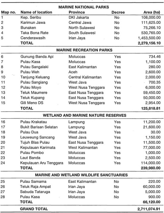
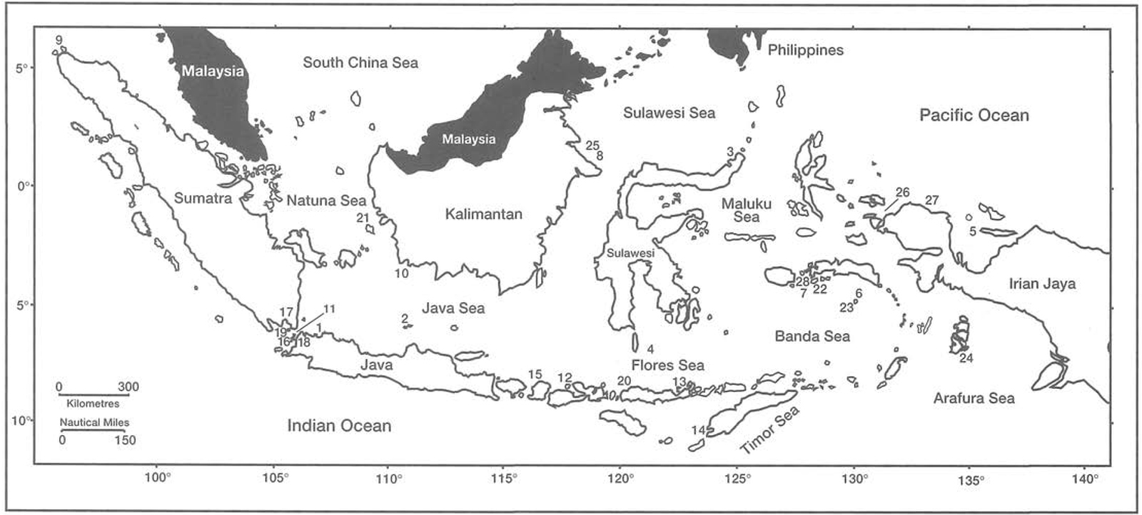
Figure 22.1. Location of marine protected areas (MPAs) in Indonesia. Numbers correspond to 'Map numbers' in table 22.1.
There is an urgent need to review existing, mainly unisectoral, policies that resulted in the establishment of numerous MPAs. Many are of questionable conservation value, and all are without appropriate management plans. There is a clear danger that the designation of marine protected areas without sufficient data and management plans will lead to future conflicts and impasses that will constrain the objectives of this key marine conservation initiative.
Table 22.2. Type of conservation areas in Indonesia according to Act No. 5 of 1990, 'Concerning Conservation of Living Resources and their Ecosystems'.
Box 22.1. Management of Indonesia's coastal and marine resources.
J. R. Clark, Rosenstiel School of Marine and Atmospheric Sciences, University of Miami, Florida.
Prospects for Management
The shoreline is a frontier that stands between two different worlds: the solid world and the liquid world. Both worlds — earth and water — hold resources of immense value to Indonesia. But these resources are limited and must be conserved on both sides of the frontier. Indonesia has conservation programs that treat both land and water resources, but no program that treats them together in a unified manner.
It is important, but difficult, to conserve such valuable littoral resources as beaches, coral reefs, seagrass beds, mangrove forests, and coastal lagoons and also to protect fisheries, wildlife, and water quality. To conserve and protect any one of these components, both land and water must be managed and to do it effectively they must be managed together. This requires a program especially framed for joint management of land and water. Many other countries have worked out the special strategies needed for conservation of coastal resources. These strategies rely on innovative forms of planning and resource management known as Integrated Coastal Zone Management (ICZM). Experience in these countries shows that such programs add to the economic and social prosperity of coastal communities (see the Coastal Zone Management Handbook by John R. Clark, 1996, Wiley/CRC Publishers, Boca Raton, Florida, U.S.A.).
Sustained fisheries productivity, increased tourism revenues, sustained mangrove forestry, and protection of lives and property from sea storms are among the practical benefits of coastal zone planning and management. An effective ICZM program can also be a major force for maintaining coastal biodiversity, for resolving conflicting demands over the use of coastal resources, and for guaranteeing the long-term economic sustainability of the coastal resource base.
Dimensions of the Coastal Zone
Coastal zones are unique because they form the transition from sea to land. Such things as daily tides, mangrove forests, coral reefs, tidal flats, sea beaches, storm waves, estuaries and barrier islands are found only at the coast.
The coast is a place where a great abundance of life is nurtured and must be conserved in the face of great development pressures. It is a place of high priority interest to citizens, to commerce, to tourism, to the military, and to a variety of industries. It attracts dense populations and undergoes great environmental modification and deterioration through land conversion, sea dredging, and air and water pollution caused by urban, industrial, and agricultural development.
All ICZM programs are expected to include both land and water within their zone boundaries. But the coastal zone may be drawn wide or narrow to meet program goals. There is no universal set of boundaries for the zone — they derive from the purposes of the particular program. It is desirable to include in the Coastal Zone all land areas affected by the sea (the "dryside") and all coastal water areas influenced by the land (the "wetside").
At the minimum, an administrative Coastal Zone must include the intertidal and supratidal zones of the water's edge that include coastal flood plains, mangroves, marshes and tideflats as well as beaches and dunes and fringing coral reefs. This is the transition place where agency authority changes abruptly, where storms hit, where waterfront development locates, where boats make their landfalls, and where some of the richest aquatic habitat is found. It is also the place where terrestrial-type planning and resource management programs are at their weakest. It is the core of the coastal zone.
Conservation of the publicly owned common property resources of the "wetside" is usually the focus of ICZM. But to do this it is often necessary to control use of public and private property of the "dryside". Coastal waters are considered "commons"; that is, they are not owned by any person or agency but are common property available equally to all citizens, with the government as "trustee". This is a public right deriving from the ages-old concepts of "…naturali jure …"
Problems Solved by ICZM
Integrated management is uniquely effective at solving environmental problems and resolving a wide variety of resource use conflicts. Examples are given below:
Land use: Land can strongly affect the sea. Impacts on coastal ecosystems include: industrial and agricultural pollution; siltation from eroded uplands; filling to provide sites for industry, housing, recreation, airports, and farmland; dredging to create, deepen, and improve harbours; quarrying; and the excessive cutting of mangroves for fuel. The impacts reduce biological diversity, natural resource abundance (food and fiber), quality of life, community security (from sea storms), and tourism revenues. ICZM anticipates such effects and offers solutions, particularly to the unnecessary sources of damage.
Resource depletion: Renewable coastal resource uses are economically limited. Over time, the economic demand for a given resource will commonly exceed the supply, be it arable land, forests or fisheries. Sustainable use management, achieved by conservation practices, ensures that renewable resources are not jeopardized but remain available to us and future generations. ICZM provides a format for sustainability.
Pollution: Aside from outright fish kills and other dramatic effects — such as human disease — pollution causes pervasive and continuous degradation that is evidenced by the depletion of fish and shellfish, decline in carrying capacity, and uglification of tourist areas. Coastal seas are susceptible to pollution carried to the coast by streams and rivers.
Biodiversity: Biodiversity conservation — protection of species and their habitats — is a necessary part of ICZM. Species protection is needed for reasons of both ethics and economic self-interest. One of the unfortunate consequences of uncontrolled growth and development has been the reduction, and even extermination, of species that have medical, educational, historical, recreational, and scientific value.
Threats to the unique biological systems of the coastal zone — species and their habitats — arise from development activities and their side-effects, including reef and beach mining, shoreline filling, and marine construction, lagoon pollution, sedimentation, and construction activities. Because much of species loss is due to habitat loss, it is important to conserve habitats which support endangered and threatened species. Effective programs will include both regulatory and custodial, or "protected areas", components.
Landscape: The coastal landscape is special and needs special attention to protect its scenic quality and to guarantee community access to waters, beaches, hillsides, and forest resources. Preservation of landscape values can be addressed efficiently by an ICZM program through land-use management of the "dryside" of the coast. ICZM addresses preservation of especially productive or scenic natural resources through special zoning or as national parks or scenic areas.
Eroding shorelines: Eroding shorelines are a problem to those who build or live too close to the shoreline. But erosion is predictable and can be countered by moving structures back a certain distance from the shoreline. Thus erosion management is a land-use matter. Corrective measures must consider the present rising level of the sea which makes erosion events more serious. ICZM advocates non-structural land-use type approaches to the erosion problem such as setback lines (for structures).
Sea level rise: Along much of the world's shoreline, sea level is rising at a significant rate — e.g., more than one foot (30 centimetres) in the past 100 years in some places — under the influence of global warming, caused by release of carbon dioxide (and other gases) into the atmosphere and then melting of glaciers, heating (and expansion) of the ocean water mass, and meltdown and disintegration of the Antarctic ice cap.
Low-lying communities have to choose whether to retreat or entrench (e.g., to move back or build dikes). Retreat — the most practicable approach — can be accomplished with setback standards for threatened areas which may preclude rebuilding if a structure is damaged.
The ICZM Management System
ICZM is a system for resource management in the critical zone where land and sea interact. It is a comprehensive program which both manages development and conserves natural resources, and while so doing, integrates the concerns of relevant economic sectors and societal interests.
The key is unitary zone management — treating the shorelands and coastal waters as a single interacting unit. Because it operates at the water/land interface, every aspect of ICZM relates to water in one way or another, whether making provisions for marine commerce or the ravages of sea storms, or resource conservation, or pollution abatement. The water influence not only establishes special conditions, it also dictates unusual and complex institutional arrangements.
The special role of ICZM-type programs is that they are centrally supported and apply integrated, area-wide, resources planning and management to the distinct landforms and waters of the coast. The coast is a place where special knowledge, techniques, and governance methods are essential.
ICZM focuses on sustaining coastal resources, conserving the littoral environment, and countering natural hazards. It does so by influencing the form of shoreline development, by encouraging broad civic participation, by coordinating actions of the government and the private sector, and by spreading knowledge.
In its planning mode, ICZM examines the consequences of various development actions and proposes necessary safeguards, constraints, and development alternatives that will guarantee sustainable development and the sustainable use of coastal natural resources, at the most productive levels possible.
In its management (or "implementation") mode, ICZM assesses the environmental and socioeconomic impacts of specific development projects and recommends changes necessary to conserve resources and protect biodiversity. ICZM coordinates actions of various economic sectors to ensure that advances in one sector do not bring reverses in another; for example, that port development does not unnecessarily diminish local fisheries or tourism.
Because the water's edge is a place where competition and conflict among resources users is great, governments are slow to develop special policies and programs. One advantage of the ICZM (multiple use) approach over the traditional sectoral (single use) approach is that it provides a framework for resolution of arguments over who gets to use which resources when and how. ICZM also addresses conflicts between economic development and resource conservation needs.
Premises and Methods
The concepts and methodologies of ICZM are taken from standard governmental planning and management approaches. So while ICZM-type programs are distinctive in purpose, they are rooted in such well-known and standard approaches as regional development planning and watershed management.
Sustainability: Sustainable use is the alternative to resource depletion from exploitation for short-term profit. Coastal ecosystems and key coastal habitats — such as coral reefs and mangrove forests — are not only distinctive, but extremely productive of renewable resources such as protein food, tourist income, mangrove forest products, and other economic goods and services. These resource systems must be conserved to continue.
Multiple use: In marine areas, fishermen, dive boats, ports, marinas, yacht anchorings, water sports, factories, oil terminals, waste outfalls and transportation systems often combine to create examples of multiple use. Tourism can intensify competition and conflict with these uses. Certain uses can coexist in an ICZM program that encourages multiple use while others might have to be severely restricted. ICZM's role is to sort out the uses and recommend the optimal mix.
Strategy planning: This is the initial program stage and is where the potential impacts of the ICZM policy action are explored (on resources and resource users, on income and jobs, on social and cultural well-being), where benefits are evaluated, where a wide array of data is accumulated, and where a general strategy is created and recommendations are made for organization and administration of an ICZM program.
The Strategy Plan recognizes that the habitats of coastal zones are so different from their terrestrial counterparts as to require different and special forms of conservation — e.g., coral reefs, beaches, coastal lagoons, submerged seagrass meadows, and intertidal mangrove forests. Also, the species involved are quite different (e.g., oysters, octopuses, porpoises, whales, sea fishes, sea turtles, dugongs).
Integrated management: It is an axiom of ICZM that only a truly integrated program (i.e., one that includes all the major sectors affected) can succeed. If important stakeholders are left out — e.g., tribal chiefs, port authorities, housing departments, tourist industries, fishermen, economic development planners — ICZM can fail. Therefore, a major function of ICZM is to provide a framework for coordination of a wide array of interests.
Community-based management: To be effective, coastal resource management needs much more than regulation. Resource management should be rooted in local communities and thus should be designed to empower local communities to conserve their own resources. This can be done by forging linkages to community leaders, town mayor and council, local law enforcement officers, private businesses, and national government organizations like tourist authorities, environmental or fishery agencies. Combining community, scientific and legal approaches tailored to particular sites can succeed. In short, empowering communities is better than commanding them.
Adaptive management: A key to successful environmental management is to keep the process flexible — the idea being that as circumstances change and more knowledge and experience are added to the process, the management program itself should adapt. Adaptive management is more a style than a form of management and usually suggests a data-rich process.
Land-use planning: The coastal zone faces intense conflict between private property-based operations in shorelands and public property-based activities in the tidelands and coastal waters. The ICZM process may have an important mediating role between conflicting wetside and dryside land-use interests to find compatible solutions. Therefore, land use is incorporated in the ICZM Master Plan.
Because of the high value of shorefront land in both centrally planned and free market countries, it is often necessary to allocate coastal land uses according to a broader social perspective than ordinary land. A longer-term, more comprehensive and integrated approach is appropriate, one that includes conservation and social equity as well as economic growth.
Land-use planning identifies parcels of land for particular classes of use — e.g., port warehouses, condominiums, houses, shops, open space, and other zones. This zoning can set aside key areas for conservation as well as developments such as tourist facilities, port expansions, or aquaculture ponds.
Zoning of resource areas: Zoning has come into common use for publicly owned resources (e.g., "the commons"). Zoning serves two main purposes in coastal conservation: 1) regulatory — for regulatory programs to designate certain areas for particular uses, and 2) custodial — for nature reserves, to subdivide them into particular use allocation zones (e.g., diving, nature study, fishing, protection of breeding areas, water sports).
Watershed management: ICZM should, to the extent possible, try to influence upland development activities although it has been uncommon for those who plan dams or land-clearing enterprises to consult with coastal interests. But coastal resources are jeopardized when the terrain of the coastal watershed is cleared of vegetation for agriculture; when it is altered to accelerate drainage, when surface water bodies and watercourses are filled, detoured, or channelized; and when fresh water flow to the coast is laden with sediment.
Nature reserves: The ICZM Strategy Plan addresses natural area protection — e.g., coastal nature reserves, marine national parks — which is the custodial facet of the program. Custodial protection is integrated into ICZM programs so that managing a nature reserve or marine park is not done in isolation from surrounding land uses and peoples, nor without interagency cooperation.
Buffer zones: In an ICZM regulatory program, a restricted buffer zone, or strip, can be set aside to preserve key habitats that lie along the shoreline, such as mangrove wetlands. A buffer strip of unaltered land is often recommended between the water's edge and any structures or land alteration (see "Setbacks" below). Vegetated buffer strips provide water quality protection by detaining runoff, trapping sediment, and preventing increased turbidities of adjacent coastal waters. In some cases the coastal setback constitutes a "green belt" — a band of storm-protecting trees extending along the shoreline (as for Java).
In custodial programs — resource reserves, etc. — the "buffer zone" is often one of several classes of zonation, being a border zone meant to separate the reserve from the surrounding, usually private, area.
Zone of Influence: ICZM can be organized to address uses in the important Zone of Influence (ZOI) that lies just outside the protected area boundaries in order to discourage encroachment into these areas. Other purposes are to reduce pollution from external sources, limit destruction of special "nurturing" habitats, and minimize other types of external impact that could be damaging to the protected area.
Setbacks: A key component of an ICZM program is a "setback" provision whereby coastal development is kept back from the shoreline. Setback lines provide buffer strips between the ocean and upland property. Setbacks have many uses in an ICZM program, including designation of a "line of retreat" to keep structures away from the active part of an eroding beach.
Note that the same setback requirement that protects beachfront structures from erosion and storm waves can also preserve turtle nesting sites, mangrove forests, sand dunes, etc.
Monitoring: When approving a coastal development project with potential environmental impacts, the ICZM approach requires baseline data and monitoring to evaluate actual impacts. ICZM programs use two major types of monitoring — strategic and tactical. The strategic level is the "retrospective", or "hindsight" monitoring which is done to determine a permitted project's effects. This of course requires that "benchmark" information be collected before the project starts. The tactical level is the "oversight", or "real time", monitoring which is done in conjunction with construction operations on a "day-by-day" basis to detect negative impacts.
Legal, Institutional, and Administrative Approaches
ICZM uses standard legal and administrative approaches but the institutional framework differs from the usual government "line agency" structure. The ICZM institution is most often an "overlay" agency, a coordinating unit. Traditional land-based or marine-based forms of management and planning can be effective if suitably modified for the coast.
Involvement: The ICZM program is supported by a specific planning process that involves all levels of government. The local governments are involved because they govern where development takes place, where resources are found, and where the benefits or costs are mainly to be felt. The central government has to be involved because responsibility and authority for marine affairs inevitably rests there (navigation, national security, migratory fish, international relations, etc.). Intermediate levels of government — e.g., state (provincial) or regional — are involved because all entities which have responsibility in the coastal area have a role in the ICZM process.
Legal foundation: The initial legislation or executive order needed to authorize the ICZM program should specifically: pronounce the goals and purposes of the ICZM program; authorize funding; pass enabling legislation; assign responsibility for strategy plan preparation to a particular agency; prescribe a method for collaboration among the various stakeholders (sectoral agencies, private sector, and the affected public); and specify a step-by-step organizing and implementing process.
ICZM programs involve a strong central government role for many reasons, not the least of which is that central government typically retains most jurisdiction over coastal and ocean waters. Nevertheless, ICZM programs can operate at a subnational level.
Administration: ICZM establishes a system for joint management of land and water. The Master Plan becomes the framework of the program. It identifies options for economic progress in the coastal area and recommends governmental and private actions to accomplish beneficial and sustainable change (i.e., change that is economically sound and socially just and that sustains the natural resource base).
Institutional arrangements: Institutionally, it is appropriate to fit an ICZM program into the current governmental structure in a manner that causes the least disruption of present institutional alignments. Political priorities are such that a new ICZM agency that would preempt the authority of existing agencies would be difficult to initiate.
If the ICZM office is located within an existing agency that already has appropriate regulatory powers, such as a natural resources, fishery, or environmental ministry, such agency must be motivated to carry out conservation management. Also, it must have objectives consistent with the ICZM legislation, and must be awarded enough responsibility, power, and administrative and technical resources to do the job. Without primacy of authority — i.e., above the level of the individual ministries or departments of government — ICZM success may be minimal.
However, for a full-scale, comprehensive program, it would be desirable to create a new agency, such as a multiple-use oriented "Coastal Authority", provided it will have the governmental support, power, and resources necessary to perform its function.
Regulation: A major purpose of the ICZM-type program is to examine proposed major development projects to determine the impacts they have on coastal resource systems and to recommend design or location changes which can eliminate or reduce any negative impacts. The system is simple: if one wishes to build a structure, reclaim tidelands, clear land, or otherwise engage in economic development activity, a permit must first be issued by government. Many countries have established coastal permit procedures designed to safeguard environmental resources.
At the centre of permit review is the formal prediction of impacts for proposed development projects, termed "environmental assessment" (EA), which is linked to the permit. The information and analysis generated in the EA provide the basis for the decision on whether a coastal project is disapproved, approved as is, or approved with conditions attached. In addition to environmental review, the natural hazard risk of the project and social and environmental impacts are often reviewed.
Planning
The role of planning: The planner's role is to deal with great complexity and reduce it to simple concepts and program means that are politically and administratively viable. Typical managers, engineers, politicians, and most planners have not usually been well-informed about the sea and the sea coast. They have much to learn at the beginning of their ICZM experience.
In narrow sectoral planning it is easy to irreversibly destroy a resource and foreclose future options for use of that resource. ICZM attempts to avoid this for coastal area resources by broad multiple-sector planning and project development, by future-oriented resource analysis, and by applying the test of sustainability to each development initiative. There are two important stages of ICZM planning — "strategy planning" and "master planning."
Strategy plan: Strategy planning is the process that explores options and develops an optimum strategy for a management program. It examines the facts, considers the issues, suggests possible solutions, and proposes specific legal and institutional arrangements. Strategy planning is the key step in the process of organizing an Integrated Coastal Zone Management (ICZM) program because the whole strategy of the process is being worked out. In this step the hows, whys, wheres, whens and whos are pretty much decided. Policies and objectives are chosen and methods determined.
The linkages between the "dryside" and "wetside" of the coast — that is, between the terrestrial and the marine realms — preclude the effective management of a marine or estuarine resource system without concurrent management of adjacent land habitats. Therefore, the planning boundaries for coastal zone planning and management are set to encompass dryside problem areas as well as wetside ones.
The Strategy Plan anticipates the Master Plan, and specifies a certain type of program to support it, requiring at the minimum the following procedures: a project-by-project review, an Environmental Assessment (EA) requirement, a permit-letting process, and a coordination function, all leading to permission for coastal development proposals.
Master plan: The strength of an ICZM program comes from its Master Plan, which is the operative basis for the program. Its components reflect the goals of the program, the method and legislative basis, rule-making, implementation strategy, staffing and financing, public participation, coastal zone boundaries, permits and environmental assessment, and other relevant aspects.
Technologies
ICZM programs use modern technologies of data acquisition, analysis, and dissemination to promote efficiency and timeliness.
Remote sensing: Remote sensing — by satellites such as LANDSAT (USA), SPOT (France) and RADARSAT (Canada) — can be helpful. The high spatial resolution of multiband radiometers on LANDSAT and SPOT, well proven for dry-side survey, also works for shallow-water surveys. Coupled with digital mapping and GIS technology, remote data have considerable potential for coastal zone planning and management (see box 22.2).
Computerized databases: With the advent of reliable, low-cost computer automation, computer storage of geographically oriented databases is now practicable. These computerized databases are often called "Geographic Information Systems" (GIS). Previously requiring large computers, GIS are now available on microcomputers and work stations, putting them within the budget of most ICZM institutions. GIS, computer-assisted mapping tools, are used in collecting, storing, retrieving, processing and displaying spatial data. The computers can be programmed for direct production of resource maps.
Cybernetics: Electronic communication via the World-Wide Web, e-mail via Internet, special forums, bulletin boards, on-line databases, and so forth, are available to professionals involved with ICZM. Cybernetic techniques have moved from the academic sphere to broad general use in ICZM information transfer.
Rapid assessment: New methods for rapid survey of communities are now available to ICZM. For example, Rapid Rural Appraisal (RRA) is a process for gathering and analyzing information from and about rural communities in a brief time period (weeks). RRA sets out to create a dialogue with project beneficiaries which can reveal information on values, opinions, objectives and local knowledge as well as "hard" data on social, economic, agricultural and ecological parameters.
Rapid information dissemination: Public information about ICZM programs can be disseminated via television and radio programming and special video series, along with print media, printed clothing (tee shirts), and other modern rapid methods.
Getting Started
The ICZM program is based on strategies deriving from clear needs, policies, goals, and objectives. In its most rudimentary form, the program can be initiated with not more than three components:
1) A central government ICZM coordination office with good communication capability;
2) A project review/permit system for major coastal developments (including EA and socioeconomic assessment);
3) Enforcement powers sufficient to ensure compliance with the program.
In this minimal mode, it is anticipated that the program would mainly review economic development proposals and issue permits for acceptable projects. The system should be kept simple initially with the creation of a small office to maintain the coordination mechanism and communication network.
VOLUME VIII PART II
COLOUR PLATES
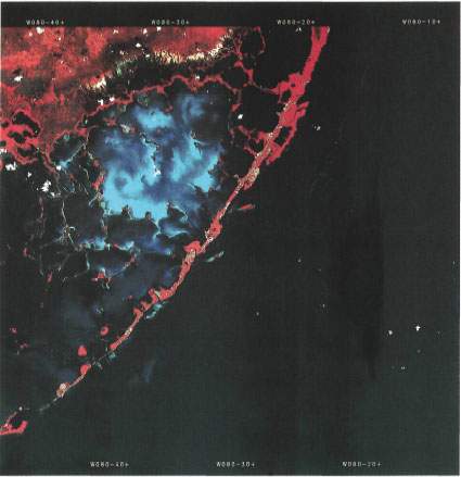
The deep channel that separates the Kepulauan Seribu high from the Java mainland, may also serve to divert and funnel highly turbid water masses originating from Borneo away from the reefs. LANDSAT false-colour image showing the movement of turbid water (reddish colour) through the deep channel. (Photo courtesy of R.K. Park, Maxus Southeast Sumatra, Jakarta)
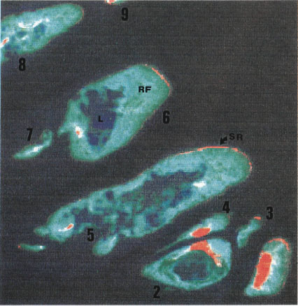
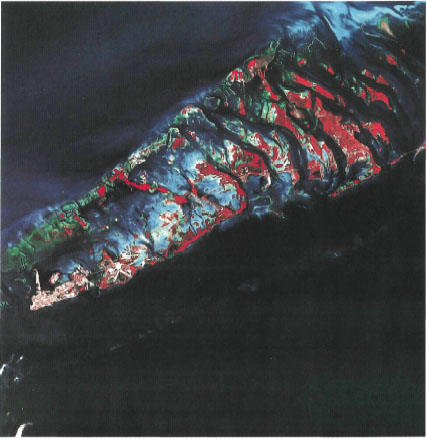
The southern patch reefs of Kepulauan Seribu. False-colour LANDSAT TM image illustrating the various reef zones. Red colour depicts supratidal vegetation (chlorophyll), and clearly distinguishes vegetated coral cays from other reef zones. Note the narrow red zones along the northeast margins of most patch reefs (e.g., 1, 3, 5, 6) representing well-developed shingle ramparts (SR) on the weather side of the reefs. Patch reef 3 has a well-developed shingle rampart cay. The narrow red bands just visible along the southeast margins of most reefs represent subaerially exposed reef crest with high coral cover which is reflected in the chlorophyll signal. Relatively deep lagoons (8-10 m) are present on reefs 2, 5 and 6. The light blue-green regions are interpreted as reef flats. White areas are unvegetated supratidal sand cays. Symbols: SR - shingle rampart; L - lagoon, RF - reef flat. Numbers:
1) Pulau Pramuka
2) Pulau Panggang
3) Gosong Pramuka
4) Pulau Karaya
5) Pulau Sempit, with P. Layar just to the southeast
6) Pulau Congkak
7) Pulau Pandan
8) Pulau Karang Bongkok
9) Pulau Opak Kecil.
(Photo courtesy of Siswandono, P30-LIPI, Ancol, Jakarta)
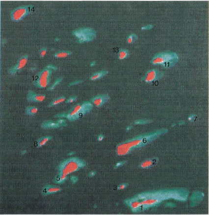
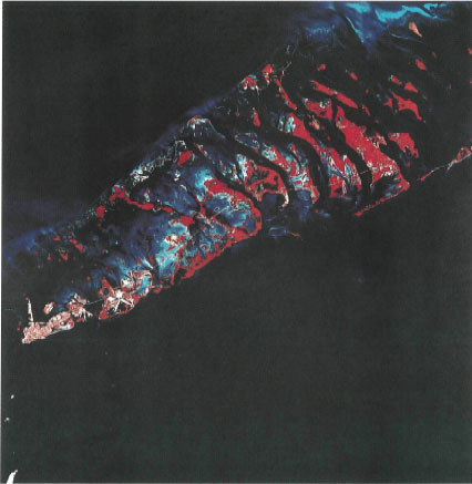
The northern patch reefs of Kepulauan Seribu. False-colour LANDSAT TM image. Red areas represent vegetated coral cays. Note the absence of lagoons. Light blue-green colour represents shallow moats and intertidal habitats. Reefs show east to west elongation reflecting the dominant current direction. Note the large size of coral cays compared to the reef size of most northern patch reefs (upper left). Numbers:
1) Pulau Pamagaran
2) Pulau Biru Kecil
3) Pulau Bulat
4) Pulau Genteng Kecil
5) Pulau Genteng Besar
6) Pulau Bira Besar
7) Pulau Belanda
8) Pulau Matahari
9) Pulau Putri Barat
10) Pulau Pelangi
11) Pulau Papetheo
12) Pulau Melintang Besar
14) Pulau Jukung.
(Photo courtesy of Siswandonol, P30-LIPI, Ancol, Jakarta)
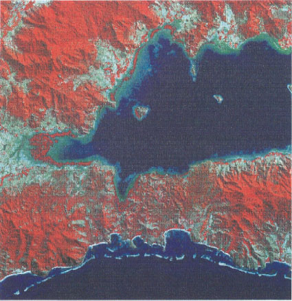
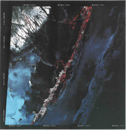
Landsat TM false-colour image of the south coast of Sumbawa, West Nusa Tenggara. The small barrier reef running along the south coast of the island is clearly distinguishable from a fringing reef due to its deep lagoon. This feature is not shown on hydrographic charts, which depict the reef as a fringing reef (Photo courtesy of Siswandono, P30-LIPI, Ancol, Jakarta)
Among the new discoveries in Kakaban Lagoon is a most unusual tunicate (Chordata; Ascidiacea). The new ascidian is Styela complexa (Kott 1995), which is an abundant member of the Rhizophora stilt root epiphytic community. (Photo by Tomas and Anmarie Tomascik)
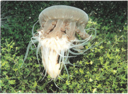
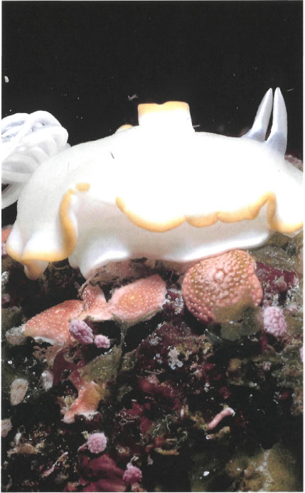
One of the most interesting findings in Kakaban Lagoon was a white (i.e., azooxanthellate) sea anemone (Actiniidae). The sea anemone is a voracious jellyfish eater, capable of devouring an entire jellyfish (i.e., Cassiopeia ornata). It is able to stretch its oral disc and body column to engulf jellyfish three times its size. The sea anemone attacks all jellyfish. (Photo courtesy of R. Steene, Cairns)
False-colour SPOT image of Sungai Sembilang proposed Wildlife Reserve in South Sumatra. (Image courtesy of Siswandono, P30-LIPI, Ancol, Jakarta)
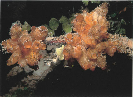
Didemnum molle is a conspicuous ascidian (sea squirt) on Indonesian reefs.
A large colony of D. molle on an exposed ledge. Note that the fully inflated test which contains calcareous spicules is perforated by numerous branchial (incurrent) apertures. The large aperture on top of the colony is the common cloacal aperture. The green colour on the surface of the test is due to the presence of Prochloron endosymbionts. (Photo by Tomas and Anmarie Tomascik)
Larva of D. molle packed with green endophotosymbiotic Prochloron. (Photo courtesy of R. Steene, Cairns)
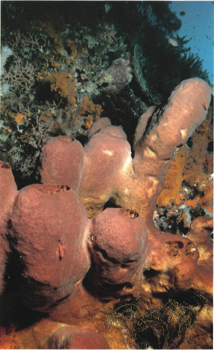
Theonella swinhoei. Sponges are second to corals in terms of their contribution to benthic faunal biomass on coral reefs. (Photo courtesy of R. Van Soest)
Sponges are a dominant and colourful group in many sheltered shallow-water habitats (depth 1 m). Kakaban Lagoon, East Kalimantan. (Photo courtesy of R. Steene, Cairns)
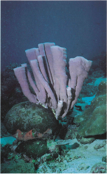
Sponges are equally colourful in deep-water environments. Pink Axinella sponge in a field of leaf-like Sinularia dura (depth 45 m). Banda Besar, Banda Islands. (Photo courtesy of C. Birkeland, University of Guam, Guam)
Many organisms are very tolerant towards settlements of sponges. Haliclona sp. growing over a massive coral. (Photo by Tomas and Anmarie Tomascik)
Chromodorid nudibranch (Chromodoris egretta) feeding on an unidentified sponge. (Photo courtesy of Ron and Valerie Taylor)
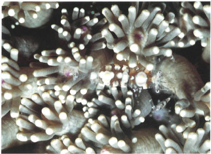
Pontoniid association with Scleractinia. Hamopontonia corallicola on Goniopora coral. Note that the colour markings on the shrimp mimic coral tentacles and the purplish spot on the tail mimics the mouth of the polyp. Ambon, 1990. (Photo by C.H. J.M. Fransen, National Museum of Natural History, Leiden)
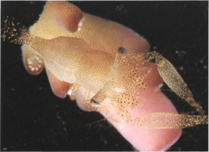
Coralliocaris superba on Acropora coral. The shrimp is at the tip of an axial corallite. SW Sulawesi, 1994. (Photo by C.H. J.M. Fransen, National Museum of Natural History, Leiden)

Colour variations of the Spiny Chromis (Acanthochromis polyacanthus) from the Coral Sea. (Photo by G.R. Allen)

Spiny Chromis from Lizard Island, Great Barrier Spiny Chromis from Madang, Papua New Reef. (Photo by G.R. Allen)
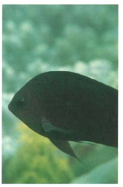
Spiny Chromis from Madang, Papua New Guinea. (Photo by G.R. Allen)
Key Largo, northern sector of the Florida Keys coral reef ecosystem, United States of America (see colour plates 22.2, 22.3, and 22.4). Note the southern tip of the state of Florida (Everglades National Park) in the upper left corner (to the northwest), the shallow (<5m) Florida Bay between Florida and Key Largo, and the deep waters of the Straits of Florida (route of the northward-flowing Gulf Stream) to the right (east). Note that the Overseas Highway that connects mainland Florida to Key West in the south is clearly visible. This is a 20-m resolution multispectral image enhanced with 10-m resolution panchromatic data from the SPOT 2 spacecraft on 9 February 1991. (Photo courtesy of SPOT Image Corporation)
An earlier image of Key Largo, northern sector of the Florida Keys coral reef ecosystem, United States of America. Note the southern tip of the state of Florida (Everglades National Park) in the upper left corner (to the northwest), the shallow (<5m) Florida Bay between Florida and Key Largo, and the deep waters of the Straits of Florida (route of the northward-flowing Gulf Stream) to the right (east). Note that the Overseas Highway that connects mainland Florida to Key West in the south is clearly visible. This is a 20-m resolution multispectral image enhanced with 10-m resolution panchromatic data from the SPOT 1 spacecraft on 7 April 1988. Time sequences of images like these have been used to detect and quantify environmental change. (Photo courtesy of SPOT Image Corporation)
An earlier image of Key Largo, northern sector of the Florida Keys coral reef ecosystem, United States of America. Note the southern tip of the state of Florida (Everglades National Park) in the upper left corner (to the northwest), the shallow (<5m) Florida Bay between Florida and Key Largo, and the deep waters of the Straits of Florida (route of the northward-flowing Gulf Stream) to the right (east). Note that the Overseas Highway that connects mainland Florida to Key West in the south is clearly visible. This is a 20-m resolution multispectral image enhanced with 10-m resolution panchromatic data from the SPOT 1 spacecraft on 7 April 1988. Time sequences of images like these have been used to detect and quantify environmental change. (Photo courtesy of SPOT Image Corporation)
Key Largo, southern sector of the Florida Keys coral reef ecosystem, United States of America. Farthest west (far left) is Key West, the shallower waters of Florida Bay and the Gulf or Mexico to the north (top), and the deep waters of the Straits of Florida (route of the northward-flowing Gulf Stream) at the bottom (south). Note that the Overseas Highway that connects mainland Florida to Key West in the south is clearly visible. The various Keys (islands), coral formations, sand banks, and channels are clearly seen. This is a 20-m resolution multispectral image enhanced with 10-m resolution panchromatic data from the SPOT 1 spacecraft on 31 January 1987. (Photo courtesy of SPOT Image Corporation)
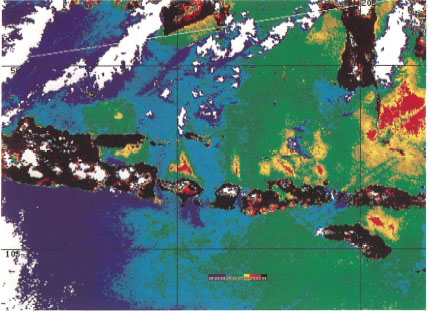
This NOAA-11 spacecraft image shows sea surface temperature data (SST) from the Advance Very High Resolution Radiometer (AVHRR) for 25 October 1991.
Note upwelling and mixing in the channels between the islands.
Note hot spots to the north of several islands can be seen to coincide with calm waters (sunglint in the visible channel image - not shown).

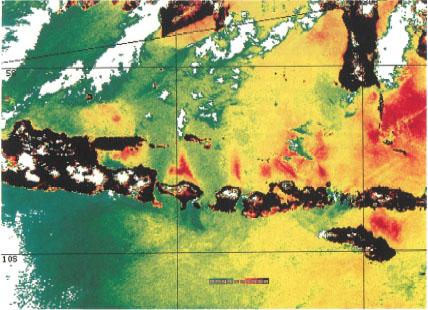
This AVHRR SST split image shows average April 1991 SST.
This AVHRR SST split image shows a new high-resolution satellite-only SST climatology for April based on nighttime-AVHRR data from 1984 to 1993 (Courtesy of Winter and Strong 1995).
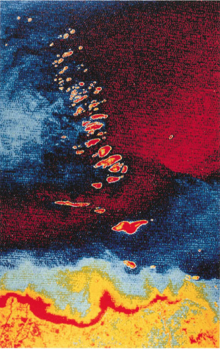
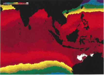
Nimbus 7 Coastal Zone Colour Scanner [CZCS] image on 20 May 1981 of the Lesser Sunda Islands, Indonesia (Java, left [west]; Bali, centre; Sumbawa, right [east]) portraying near-surface pigment concentrations [viz., chlorophyll-a]. Higher pigment levels are coloured with warmer tones of yellows and reds.
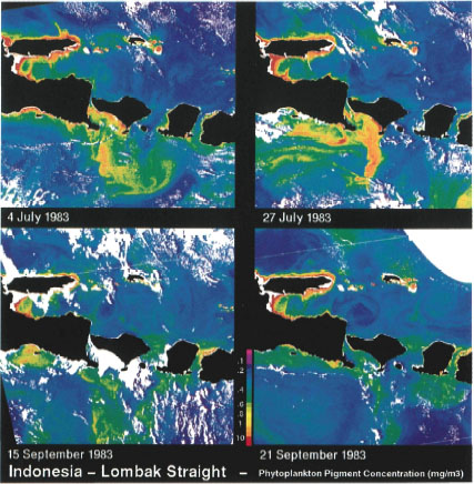
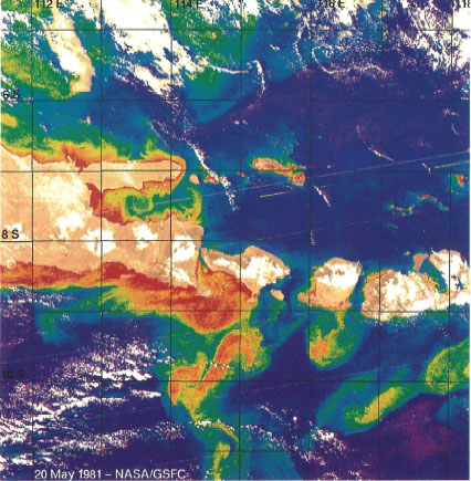
Four Nimbus 7 Coastal Zone Colour Scanner [CZCS] images from July and September 1983 of the Lesser Sunda Islands, Indonesia (Java, left [west]; Bali, centre; Sumbawa, right [east]) portraying near-surface pigment concentrations [viz., chlorophyll-a]. Higher pigment levels are coloured with warmer tones of yellows, greens, and reds.
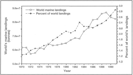
Figure 22.2. World fisheries landings in tonnes and Indonesian total fisheries landings as percentage of world's total from 1970 to 1990.
FAO 1993.
CRITICAL ECOSYSTEMS AND FISHERIES
Much of Indonesian coastline is fringed by coral reefs, mangrove forests, seagrass beds and intertidal mud flats (Salm 1984; Nontji 1993). However, the extent of these systems is still unknown, and their interactions remain generally unquantified. The highest diversity of coral reef types is in the eastern part of the archipelago, particularly around islands in the deep clear seas of central Indonesia. Coral reefs and their associated shallow-water habitats such as reef flats, seagrass beds and lagoons, support possibly the richest marine fauna in Indonesia. Seagrasses are found throughout the archipelago, but our knowledge on their distribution is extremely limited. More is, however, known about mangrove forests, primarily because of their greater visibility and economic importance to the national economy.
It has been estimated that well over 30% of coral reef resources, as well as 26% of the world's mangrove forests, are found in Southeast Asia, with Indonesia having the largest share of these riches (Yong 1989). Indonesia's contribution to the world's total fisheries landings (i.e., marine, brackish and fresh water) has been steadily increasing during the past two decades (fig. 22.2). In 1994, Indonesian marine landings reached 2.83 x 10⁶ tonnes, which is roughly 28% of ASEAN and just under 3% of the world's total landings (fig. 22.3). In Indonesia, about 60% of protein consumed by the population is derived from fisheries. About 90% of Indonesian marine landings are attributed to artisanal fisheries for direct consumption or local markets (Riopelle 1995). Recent economic valuation of coral reefs along the coast of west Lombok has demonstrated that 7100 fishermen depend on the these coastal ecosystems for their existence (Riopelle 1995). In the past, over 6% of the total catch of ASEAN marine landings was attributed to artisanal coral reef fisheries (Yong 1989). Groupers (Serranidae; kerapu), snappers (Lutjanidae; kakap), and fusiliers (Caesionidae; ekor kuning) are the three main Indonesian coral reef-associated fisheries (fig. 22.4). Riopelle (1995) demonstrated that in west Lombok, with about 10,000 ha of fringing reefs, coral reef fisheries in 1992 contributed some 2988 tonnes to total marine landings of 8316 tonnes. Furthermore, the study is the first to place a real monetary value on an Indonesian coral reef, taking into consideration such uses and functions as coral fisheries, marine tourism, mariculture, aquarium fish trade, curio trade, coral sand mining, coastal protection and biodiversity value. According to Riopelle (1995) the coral reefs along the coast of west Lombok are valued at US$5800.ha-1 (c. Rp 1300.m-2). In many parts of Indonesia, however, coral reef fisheries are heavily overexploited (fig. 22.5).
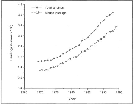
Figure 22.3. Indonesian total and marine fisheries landings (tonnes) from 1967 to 1992.
FAO 1993.
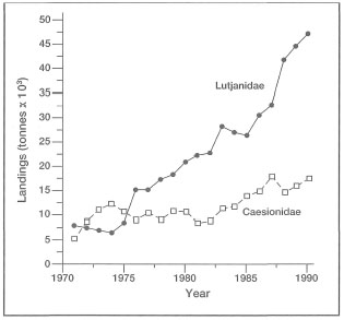
Figure 22.4. Indonesian coral reef fisheries. Landings (in tonnes) for two main reef fisheries, Lutjanidae (snappers) and Caesionidae (fusiliers) from 1970 to 1990.
FAO 1993.

Figure 22.5. Indonesian coral reef fisheries. Data represent landings as percentage (%) of maximum sustainable yield estimates for each area. Areas codes: 1 - western Sumatra; 2 - eastern Sumatra; 3 - Malacca Strait; 4 - northern Java; 5 - southern Java; 6 - eastern Kalimantan; 7 - southern/western Kalimantan; 8 - southern Sulawesi; 9 northern Sulawesi; 10 - Bali/NusaTenggara/T. Timor; 11 - Moluccas and Irian Jaya; 12 EEZ Indonesia; 13 - Indian Ocean (western Sumatra, Nusa Tenggara); 14 - EEZ northern Sulawesi; 15 - EEZ northern Irian Jaya; 16 - northern/western Sulawesi.
Source: MNLH 1995.
Global Perspective
Up to 1970 the world catch of marine fish was steadily rising at a rate of some 6% per year. With the collapse of the Peruvian anchoveta fishery in the early 1970s, the rate slowed dramatically and in 1980-1989 the catch declined to an annual increase of about 2.3%. In 1990 came the first global decline since 1976, with landings of 83 million tonnes, a drop of some 3% (table 22.3) (FAO 1993).
Considering Indonesian coastal and offshore fisheries, it appears that with the steadily rising human population (i.e., 1.9% in mid-1990s; KLH 1992), which is expected to reach 250 million by the year 2000 (MNLH 1995), a change from focus on short-term development of fishing fleets, to proper management is a necessary, but not sufficient, condition for sustainable development. The question that concerns most fisheries biologists and managers is whether Indonesian fisheries are reaching the limits of production from 'wild' marine resources. For a number of fisheries (e.g., reef fish, penaeid shrimps, sea cucumbers, small pelagics, sharks), this limit has already been reached, especially in the western parts of the archipelago. Chong et al. (1994) concluded that mangrove prawn stocks across the ASEAN countries are generally overfished, even though the prawn fishery in the region is largely artisanal. An additional problem with prawn stock depletion is rapid destruction of nursery habitats (e.g., seagrass beds and mangroves) through conversion and pollution (Chong et al. 1994).
There has been a continual replacement of declining stocks of traditional resources by new resources of generally lower economic value. Globally, there was an expansion of exploitation of new fisheries to replace those species that have been heavily depleted. Many replacement groups are short-lived species, and many, but not all (i.e., squids), are of lower economic value, and lower in the food chain. For example, a large squid fishery in Taka Bone Rate does little to improve the welfare of the local inhabitants. However, many species lower in the food chain have a higher potential to support heavy fishing. A significant proportion of the depleted target species are predators on coral reefs, high in the food chain. In some parts of Indonesia, landings of high value (i.e., 'top predators' such as snappers and groupers) have been declining due to overfishing. This decline has been accompanied by increased landings of small, short-lived "trash" fish, penaeid shrimps and cephalopods. Shrimp production has been rising rapidly as a result of aquaculture production (fig. 22.6), and has been accompanied by the increased use of "trash" (by-catch) fish as aquaculture food stock, to the detriment offish supplies for food (FAO 1993). Continued high fishing intensity in many parts of the Indonesian Archipelago will contribute to a loss of biological diversity, and there are fears that this may lead to more unstable, and possibly lower, catches in the future.
Table 22.3. Annual world landings of aquatic resources, excluding mammals and seaweed. Values are in millions of tonnes.
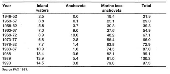
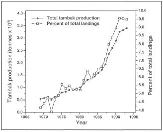
Figure 22.6. Total tambak production in tonnes and as percentage of total marine landings in Indonesia from 1969 to 1993.
Source: FAO 1993.
The development of fisheries in the western central Pacific has intensified since the 1960s, particularly in Southeast Asia. Small-scale fisheries contribute the most to the total catch. Landings reached 7.3 million tonnes in 1990, with more than 85% of the catch taken by Indonesia, Malaysia, the Philippines, Thailand and Vietnam. Demersal and small pelagic fish comprise the bulk of the total catch. However, tuna and penaeid prawns are the major Indonesian export fisheries.
Total catch has continuously increased during the past 20 years, but the rate of increase has slowed. Some demersal species such as ponyfishes (Leiognathidae), fork-tailed catfishes (Ariidae) and croakers (Sciaenidae) show signs of overexploitation, particularly in the Strait of Malacca (fig. 22.7) (FAO 1993). Large pelagic stock, notably mackerels and round scads, are heavily exploited in the Strait of Malacca and the Java Sea, while small pelagic stocks such as sardines are heavily exploited in the Bali Strait, where high productivity is maintained by strong seasonal upwelling (fig. 22.8) (SCORRAD 1990). Indonesia increased its catch in the mid-1980s mainly through expansion into the eastern parts of the archipelago. Most stock of coastal shrimp in Indonesian waters are fully exploited or overexploited (fig. 22.9). Trawl fishery has been banned since 1980 in the western part of Indonesia, but the trammel net fishery has continued pressure on the coastal shrimp stocks. Total catches have leveled off during the past decade at 100,000 to 200,000 tonnes.
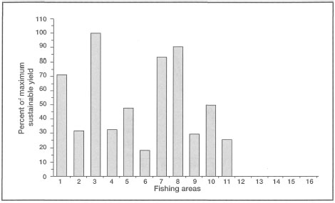
Figure 22.7. Indonesian demersal fisheries. Data represent landings as percentage (%) of maximum sustainable yield estimates for each area. Area codes: 1 - western Sumatra; 2 - eastern Sumatra; 3 - Malacca Strait; 4 - northern Java; 5 - southern Java; 6 - eastern Kalimantan; 7 southern/western Kalimantan; 8 - southern Sulawesi; 9 - northern Sulawesi; 10 - Bali/Nusa Tenggara/T. Timor; 11 - Moluccas and Irian Jaya; 12 - EEZ Indonesia; 13 - Indian Ocean (western Sumatra, Nusa Tenggara); 14 - EEZ northern Sulawesi; 15 - EEZ northern Irian Jaya; 16 northern/western Sulawesi.
Source: MNLH 1995.
The degradation of coastal environments in Indonesia is a major problem due primarily to growth in the human population, movement of people to coastal cities and coastal development in the region. Increased discharge of municipal and industrial effluents, landfill and mangrove clearing are serious concerns. Agricultural runoff continues to introduce increasing amounts of herbicides and pesticides in rivers and coastal habitats, which may reduce survival of juvenile fish and shrimp. Increased terrestrial runoff as a result of land reclamation and deforestation, as well as recent development of coastal aquaculture, contribute to the changes in the aquatic environment. Degradation of coastal environments poses a serious threat to commercially valuable marine fish populations, since coastal habitats are critical environments for the early stages of many commercially important fish and invertebrate species.
Many of the world's commercial fish species not dependent on estuarine environments at some stages of their life cycle, nevertheless inhabit large shallow continental shelf areas that are influenced by terrestrial runoff. Freshwater plumes from many rivers, often laden with heavy loads of terrigenous sediments, are spread along the coastlines rather than dispersing into the open ocean. In these dynamic areas, the processes of nutrient enrichment (i.e., eutrophication), larval transport and retention, frontal formations, and dispersion and concentration of larvae and larval food, to which life-cycles of all marine organisms are adapted, all tend to be dependent on fresh water-seawater interaction. Global use of fresh water is increasing rapidly, and the withdrawals are nearly equal to locally generated runoff. Most of the major river systems have experienced significant alterations in sediment loading. Rapid development and deforestation in Indonesian watersheds are leading to massive increases in river sediment loads in the Java Sea and other important coastal fisheries areas (FAO 1993).
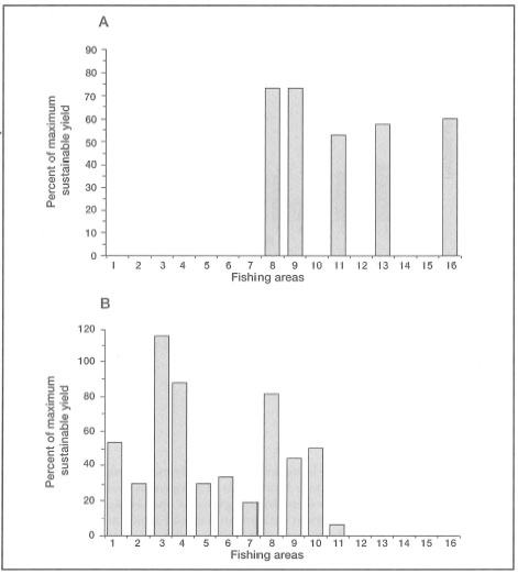
Figure 22.8. Indonesian large (A) and small (B) pelagic fisheries. Data represent landings as percentage (%) of maximum sustainable yield estimates for each area. Area codes: 1 - western Sumatra; 2 - eastern Sumatra; 3 - Malacca Strait; 4 - northern Java; 5 - southern Java; 6 - eastern Kalimantan; 7 - southern/western Kalimantan; 8 - southern Sulawesi; 9 - northern Sulawesi; 10 - Bali/NusaTenggara/T. Timor; 11 - Moluccas and Irian Jaya; 12 - EEZ Indonesia; 13 - Indian Ocean (western Sumatra, Nusa Tenggara); 14 - EEZ northern Sulawesi; 15 - EEZ northern Irian Jaya; 16 - northern/western Sulawesi.
Source: MNLH 1995.
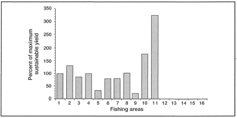
Figure 22.9. Indonesian shrimp and prawn (Penaeidae) fisheries. Data represent landings as percentage (%) of maximum sustainable yield estimates for each area. Area codes: 1 - western Sumatra; 2 - eastern Sumatra; 3 - Malacca Strait; 4 - northern Java; 5 - southern Java; 6 eastern Kalimantan; 7 -southern/western Kalimantan; 8 - southern Sulawesi; 9 - northern Sulawesi; 10 - Bali/NusaTenggara/T. Timor; 11 - Moluccas and Irian Jaya; 12 - EEZ Indonesia; 13 - Indian Ocean (western Sumatra, Nusa Tenggara); 14 - EEZ northern Sulawesi; 15 - EEZ northern Irian Jaya; 16 -northern/western Sulawesi.
Source: MNLH 1995.
Environmental Perturbations and Fisheries Production
The same factors of human population growth, intensive agriculture, industrial development, and deforestation that affect fresh water, estuarine and coastal ecosystems, also act to change the basic climatic context in which these processes operate (FAO 1993). Continual accumulation of carbon dioxide and other greenhouse gases in the earth's atmosphere lead to predictions of global climate changes (Houghton et al. 1990). There seems to be a consensus that substantial climate changes are likely to occur over a relatively brief time scale (i.e., decades). Many marine organisms typically have complex life cycles that are dependent on dynamic processes acting within the ocean-atmosphere system, which are ultimately driven by the pattern of global heating. It is the pattern of global heating that may ultimately be altered by the continuous release of greenhouse gases (Houghton et al. 1990).
The Intergovernmental Panel on Climate Change (IPCC) has concluded that a doubling of carbon dioxide in the atmosphere will most likely occur between now and the year 2050, with a corresponding increase in mean global temperature in the range of 1.5° to 4.5°C (Houghton et al. 1990). The global rise in temperature would also be accompanied by the adiabatic increase in ocean volume, resulting in a sea level rise of approximately 20 cm by 2050, with an average increase of surface sea temperature ranging between 0.2° to 2.5°C (Houghton et al. 1990).
Environmental changes associated with global climate change are many and varied. It is well-known that temperature has pronounced physiological effects on marine organisms (i.e., directly controlling physiological rates of poikilotherms), especially in tropical regions where marine organisms live very close to their upper thermal lethal limits (Johannes 1975). Because of the rapid rate of change, unparalleled in Earth's history, biological adaptations to these new conditions will lag substantially. Thus many marine species will lose access to ocean structures and inferences (e.g., environmental cues) vital to their reproductive strategies. Migratory navigation may be dependent on thermal cues from oceanic temperature gradients and isotherm positions, and hence, finely tuned migratory behaviour may be disrupted. There may be changes in overlaps among various predators and prey species, altering the viability of certain populations within them. One concrete effect, which is evident in response to normal climatic variation, is the latitudinal movement of the centre of stock distributions in relation to maritime boundaries, which could lead to de facto changes in allocation of fishery resources between adjacent coastal areas (FAO 1993).
Variations in the wind conditions are among the most important environmental factors affecting reproduction of many marine species. One likely 'greenhouse effect' is increased contrast in temperatures between heated landmasses and the oceans during the warmer seasons. This type of temperature contrast also occurs due to deforestation which allows higher heating of land, large-scale coastal development, and to the expansion of megacities such as Jakarta. Large scale changes in natural vegetation cover would magnify sea breezes and alongshore winds, enhance wind-driven offshore transport in the surface layer, and intensify upwelling and turbulence in coastal regions (Bakun 1990). However, the greenhouse effect will tend to lessen the tropical-polar gradient in global heating, which may affect the strength of the monsoonal system. Weakening of the Southeast Monsoon may significantly alter the present-day upwelling regime in the Banda Sea and the Arafura Basin, with a possible net reduction in regional productivity.
Sea level rise would have a mixed effect. On one hand, it could impact on many shallow-water nursery grounds. Inundation and coastal erosion could lead to increased marine productivity, but also eutrophication and pollution of marine habitats. While sea level rise is not a new natural phenomenon, too rapid a rise may drown some coral reefs and reduce fishery production and biological diversity.
Reduction of the ozone, allowing a higher incidence of UV radiation, may have a detrimental impact on many shallow-water communities, as well as human populations such as fishermen, who are exposed for long periods to the radiation from the tropical sun.
COASTAL FISH/SHRIMP PONDS (TAMBAKS)
Detailed review of Indonesian brackishwater ponds or tambaks is given in Soegiarto and Polunin (1981). Tambaks have a long history in Indonesia and are dominant coastal features in many parts of the archipelago, notably along the north coast of Java, in Aceh Province of North Sumatra and in South Sulawesi. Most tambaks are situated on reclaimed mangrove lands, and as a result considerable destruction of mangrove forests has occurred. This is creating a management dilemma, since the destruction of mangrove forests is degrading critical habitats of species that are being cultured, thus placing in danger genetic diversity of future breeding stocks.
Penaeid prawns are the main target species for cultivation. Of these, Penaeus monodon (i.e., the jumbo tiger shrimp) is the most economically valuable species. Other commercially important species are P. merguiensis, P. indicus, Metapenaeus ensis and M. affinis. These panaeids are still relatively abundant in some coastal waters, and, as a result, are frequently cultivated in artisanal ponds. More recently, the cultivation of Macrobrachium rosenbergii and M. carcinus (Palaemonidae) has been gaining popularity, and their use in aquaculture has received a lot of attention worldwide.
A variety of crabs inhabit tambak environments and the two most important are the mangrove crab Scylla serrata and the blue swimming crab Portunus pelagicus. Both species are being cultivated on a limited basis, and are, economically, highly valuable species.
In addition to cultivation of crustaceans and fish (i.e., Chanos chanos, milkfish) tambaks are also important habitats for a number of economically important seaweeds. Green algae (Chlorophyceae) such as Chaetomorpha, Cladophora and Enteromorpha are valuable species as they are essential for raising Chanos chanos (Rabanal 1982). In some coastal areas, green algae such as Caulerpa racemosa (fig. 22.10) are also used directly by people as food. Caulerpa is gathered or cultivated in marine and brackishwater areas.
Tambaks also support a variety of diatoms (Bacillariophyta), which are used as food for hatchery-raised shrimps and fish in artisanal ponds. However, species of Skeletonema, Tetraselmis, Cyclotella, Thalassiosira and Nitzschia are now being produced in pure mass cultures by standardized techniques to meet market demands. Culture of macrophytes in tambaks has not progressed, however some representatives of Gracilaria can be cultured in open or in impounded brackishwater areas. The use of macrophytes as a nutrient purifier for tambak effluent has received only scant attention in Indonesia, even though polyculture with bivalves could be economically feasible and environmentally sound, since the algae can remove considerable amounts of dissolved nutrients, while filter-feeding bivalves can remove suspended particulate matter.
Figure 22.10. Caulerpa racemosa is often consumed as a green vegetable by coastal people. Kakaban Island, East Kalimantan.
Photo by Tomas and Anmarie Tomascik.
Tambak Culture Methods
The Presidential Decree No. 39/1980, which effectively banned trawlers from the western parts of Indonesia, notably the shallow coastal regions of the Java Sea, was a significant legislation that provided a high degree of protection for coastal fisheries along the north coast of Java and south coasts of South and Central Kalimantan. As the price of penaeid prawns became more economically attractive in the early 1980s, large areas in the coastal flood plains were converted into tambaks, invariably at the expense of mangroves. At present there are three types of tambaks being used, namely, extensive, semi-intensive and intensive (Naamin 1987).
Extensive tambaks are dependent on the natural productivity of the reclaimed area and are considered as artisanal. Operation of the extensive tambak involves initial stocking (often natural), water management, disease control, fertilizer supply (occasionally) and tambak management. Extensive tambaks have low investment and operational costs, but they also have relatively low production rates. On an average, extensive tambaks produce about 100-200 kg of prawns.ha-1.season-1, or 200-400 kg.ha-1.yr-1, depending on the quality of the tambak system and the environmental setting. To improve productivity, extensive tambaks are now frequently stocked with shrimp seed, with a stocking density of about 10,000 ha-1.season-1. However, subsequent to stocking, artificial feed is generally not provided, thus the final prawn harvest depends entirely on the natural productivity of the tambak system itself, and as a result, appropriate siting of extensive tambaks is very important.
Semi-intensive tambaks are similar to extensive tambaks, since they still depend on the natural productivity of the system. However, in this culture the prawns are provided with additional feed. The stocking rate is about 10,000 ha-1.season-1. Supplemental protein, vitamins and minerals are provided in feed, since the natural system cannot supply the nutritional requirements of such a large biomass of prawns or fish. The production of semi-intensive tambaks is about 500 kg of prawns.ha-1 season-1, or 1000 kg.ha-1.yr-1.
Intensive tambaks may be considered as artificial systems independent of natural productivity, and totally dependent on technology. Prawns (or fish) in intensive tambaks are fed with high quantities of nutrient-rich and vitamin-supplemented foods that can support stocking densities of 20-40 prawn seeds.m-2, or 200,000-400,000 ha-1.season-1. Water quality is maintained through pumping and aerating systems requiring technological input. Even though production rates are high (4-8 tonnes.ha-1.season-1, with an average of about 6 tonnes.ha-1.season-1), intensive tambaks require large investment capital. To produce six tonnes of prawns per ha per season requires 12 tonnes of feed (conversion factor 1 : 2), which is currently (i.e., 1996) valued at about US$21,000 (the price of imported feed is US$1.80/kg). In addition, initial stocking with about 200,000 juvenile prawns costs about US$6000. To produce six tonnes of shrimp.ha-1.season-1 requires an investment capital of about US$30,000. High investment costs restrict intensive tambak culture to a small group of high capital investors mainly in Aceh, North Sumatra, West Java, Central Java, East Java, South Sulawesi, and Central Sulawesi. At present, there are only about 15,000 ha of intensive tambaks in operation. The extent of Indonesian tambaks is given in table 22.4.
Table 22.4. Distribution and area of coastal fish ponds (tambaks) in Indonesia.

ENVIRONMENTAL MANAGEMENT
This section provides a general background on environmentally related issues that are pertinent to the management arid conservation of most tropical marine and coastal shallow-water ecosystems. General environmental management guidelines for a number of key marine and coastal development activities, relevant to coral reefs but widely applicable to other marine and coastal shallow-water ecosystems, are outlined. The section is structured to provide basic environmental and ecological information on coral reef ecosystems, either from an ecosystem-oriented or development-oriented point of view, or both. The aim is to provide information on general environmental standards that need to be met to ensure continuous ecological functioning of shallow-water marine and coastal ecosystems, thus protecting a wide range of goods and services that are dependent on their continuous wellbeing. The section also provides some basic information on environmental study design and monitoring. It is stressed that the concepts discussed in this section are, with some modifications, generally applicable to a wide spectrum of marine and coastal shallow-water ecosystems. Since it is not possible in this volume to cover each ecosystem separately, we selected coral reefs as the example, mainly because of their sensitivity to anthropogenic impacts and because they are currently at the forefront of marine conservation issues.
Indonesian coral reef ecosystems are vital coastal and offshore habitats that, as history tells us, exhibit great resilience to a wide range and intensities of natural disturbances. However, what is also clear is that coral reef communities are very sensitive to a wide spectrum of anthropogenic (i.e., human-induced) impacts (Tomascik et al. 1993; Suharsono and Tuti 1994). Because of their sensitivity to anthropogenically induced stresses and the cross-sectoral benefits that they provide, coral reef resources (e.g., reef fisheries and tourism) need to be managed in an integrated manner. Indonesia has one of the strongest environmental legislation frameworks in the world, which has unfortunately not been used to its full potential. The environmental impact assessment (EIA) process is only one example of a powerful management tool, which, if applied as intended — too often not the case — can provide planners and decision-makers with much-needed information essential for the sound management of proposed projects.
EIA in Coral Reef Management
Environmental impact assessment (EIA) is a vital tool for sound management and conservation of marine and coastal ecosystems, especially in nations with rapidly expanding economies (Carpenter and Maragos 1989). EIA is an essential and indispensable part of the development process, and should be viewed as a "constructive, pro-development management tool for management that improves the success of and lengthens the life of projects" (Carpenter and Maragos 1989). When viewed in this context, the EIA process addresses key issues, such as human health and well-being, sustainable development, development opportunities, project siting, and the functional maintenance of natural ecosystems.
Biswas and Geping (1987) state the following objectives for applying the EIA in developing countries:
· To identify adverse environmental problems that may be expected to occur.
· To incorporate into the development action appropriate mitigating measures.
· To identify environmental benefits and costs of the project as well as its economic and environmental acceptability to the community.
· To identify critical environmental problems which require further studies and/or monitoring.
· To examine and select the optimal alternative from the various relevant options available.
· To involve the public in the decision-making process related to the environment.
· To assist all parties involved in development and environmental affairs to understand their roles, responsibilities and overall relationships with one another.
The above objectives clearly point out that EIA is a proactive tool. A major failure of many environmental management programs is that they are purely reactive, thus action is taken only after a problem has been identified. The EIA process works from the opposite end. The process is used to identify all relevant environmental issues associated with the particular development activity, and to develop and apply solutions before potential environmental problems are manifested. It is important to stress that EIA applied to development projects in coastal zones, especially in the proximity of coral reef ecosystems and associated habitats, must have a holistic approach. Carpenter and Maragos (1989) point out that any attempt to apply the EIA process separately to the multitude of interdependent and interacting components of a complex ecosystem, such as the coral reef, will most likely fail. The initial letters E, I, and A, also describe three important attributes of sound environmental impact assessment (Carpenter and Maragos 1989):
|
EARLY: |
"The EIA begins at the inception of development planning in order to identify opportunities and constraints in natural systems and thus guide the design of projects." |
|
INTEGRATED: |
"The EIA is linked directly to engineering and economic studies, not performed separately or at a later time." |
|
ALWAYS: |
"The EIA process continues to accumulate data throughout the project cycle, monitoring the implementation of environmental protection measures and suggesting mid-course corrections to management." |
General Guidelines for EIA
The following set of general guidelines is presented in the form of questions to be asked within the EIA process. These questions are taken directly from Snedaker and Getter (1985):
· Do the plans and studies for the development activities recognize potential effects upon marine and coastal renewable resources and provide measures for their protection?
· If the development activity is in the upland watershed, is due attention given to the effects upon downstream coastal marine and coastal resources caused by alterations in river flow or water quality?
· Is consideration given to maintaining the physical condition of the land/sea transition as well as to identifying and protecting critical ecological areas,
· such as wetlands, coral reefs, seagrass beds, coastal nursery areas, beaches, sand dunes, etc.?
· Are suitable precautions taken to avoid the discharge of pollutants and excessive nutrients into marine and coastal waters, such as industrial wastes and municipal sewage?
· Is sufficient attention given to maintain the following: Ambient water salinity Ambient water temperatures Ambient water pH levels Ambient water-dissolved oxygen concentrations Ambient water nutrient concentrations Existing clarity and transparency of water Natural patterns of fresh water inflow Natural patterns of tides and water circulation
Cairns (1974) identified four critical issues that must be addressed to manage the ecological impact of heated wastewater effluents. However, these issues are relevant to most types of discharges, and should be part of the EIA process. They are as follows:
· The assimilative capacity of the particular ecosystem in the region of the proposed discharge.
· The type and amount of ecological evidence that should be gathered before operations begin.
· The type and amount of ecological evidence that should be gathered after operations begin.
· The management plan to be followed if assimilative capacity or ecological limits are exceeded.
Basic Questions in EIA
There are a number of general questions that an EIA study for development projects in coastal areas dominated by coral reefs, and other sensitive ecosystems, must address. The following questions are taken from Hopley (1989):
· What will be the impact of the proposed development on the existing commercial enterprises that are directly and/or indirectly dependent on the wellbeing of coral reefs? What are the proposed mitigating measures to ensure minimal impact?
· What impact will the proposed development have on the social fabric of the area in terms of property value, aesthetic considerations, housing, etc.? What are the proposed mitigating measures?
· How will the proposed development affect beach stability at the proposed development site and adjacent areas? What are the proposed mitigating measures?
· How will the proposed development affect the local ground water quality as well as water quality of coastal waters? What are the proposed mitigating measures?
· How will the proposed development affect coastal water circulation locally and in adjacent areas? What are the proposed mitigating measures?
· Will the proposed development cause significant (i.e., above ambient) sedimentation and turbidity of the coastal waters during the construction and operation? If so, what mitigating measures are proposed?
· What will be the construction effects from the proposed development, and what are the proposed mitigating measures?
· How will the proposed development affect the adjacent coastline? What are the proposed mitigating measures?
· Are there any rare, endangered or protected marine and terrestrial species in or near the proposed development site?
Environmental Monitoring
The development and implementation of a sound environmental monitoring program is a vital component of the EIA process. Once the pre-development baseline database has been established, continued monitoring will be required during both the construction and operational phases of the development project to determine whether impacts have occurred. Baseline data are a prerequisite to any monitoring study, since impact effects can only be detected as departures from the unimpacted state (Green 1979).
Environmental Monitoring Design. There are a number of general principles involved in planning and implementing environmental studies in the EIA process. According to Green (1979) all environmental studies should have the following four basic components:
· Survey Design
· Data Collection Program
· Data Interpretation
· Data Presentation
ENVIRONMENTAL STUDY DESIGN. While a large number of excellent books are available on this important subject, Green's (1979) "Sampling design and statistical methods for environmental biologists" stands out, and is recommended reading for all. Green (1979) has stated that in all environmental monitoring studies it is appropriate to separate variables into biological and environmental data sets. This is frequently forgotten in many studies. The choice of biological variables to be measured should be dictated by the nature of the development and the anticipated impact. In other words, the decision of what variables are to be measured should be objective-driven to test a specific hypothesis. With regards to coral reefs, the biological data set may consist of biological variables such as, but not limited to, abundance, diversity, biomass, cover or health. Note that the EIA may focus on a number of key coral reef communities such as corals, fish, invertebrates or macrophytes. The use of a single variable, such as percent coral cover, to determine if impact has occurred is clearly not sufficient.
The environmental data set should contain key environmental variables such as temperature, salinity, pH, oxygen, nutrient concentrations, or other variables dictated by the nature of the development project. Thus, if the monitoring program is being designed to assess the impact of logging, the environmental data set should focus mainly on siltation, sedimentation, turbidity, erosion, land runoff, and nutrients. On the other hand, if the EIA is being designed for an industrial development, additional variables, such as heavy metals or PCBs, must be included.
The two data sets correspond to the 'predictor and criterion' variable sets (Green 1979). The objective of the study will dictate whether the biological set is the predictor or criterion set. If one wishes to explain changes in coral species composition (i.e., coral diversity) by changes in environmental variables (e.g., turbidity or increase in nutrients), the biological set represents the criterion set. If the abundance of certain coral species, or other reef-associated organisms, is used as a predictor of a particular type and intensity of chemical pollution, then the situation is reversed. Note that the concept of 'indicator species' has thus far not been successfully applied to coral reefs, since a reliable indicator species is yet to be found. However, butterflyfish have been promoted as such, since certain species are corallivorous. Butterflyfish (Chaetodontidae) may be a useful group of reef fish for monitoring purposes, once their natural abundance and diversity in a particular area has been established. However, the use of butterflyfish in one-time/one-place rapid assessments to determine anthropogenic impacts (i.e., absence of butterfly fish equals anthropogenic impacts) is clearly not appropriate and should be avoided.
One of the most important prerequisites of a sound EIA is the application of the scientific method (Green 1979). This dictates that purely descriptive or observational studies are to be avoided at all costs, since they cannot establish causation. To establish causation requires that data collection must follow clear hypothesis formulation. If impact assessments are to help solve pollution problems, they must be directed at quantifying processes (e.g., connecting loadings, fates, ecological effects, human health risks, and economic impacts) which relate to the specific problems under consideration. Green (1979) stresses that the scientific method must be adhered to rigorously and vigorously, and that it is essential that the hypotheses should be established with respect to quantification of each process, and the requisite data should be gathered as fully and precisely as required to test these hypotheses.
Early definition of meaningful assessment end points (i.e., measures of impact that are widely accepted) is key for a successful EIA (Green 1979). It is very important to clearly define the references against which the significance of detected impacts have been measured. Examples of meaningful end points include: 1) impacts on long-lived species; 2) measurements of the uptake and effects of pollutants on organisms; 3) end points reflecting ecosystem-wide response; 4) mortality, fecundity, growth rates and age distribution of populations; and 5) population stress indices and community change indices. It is often very useful to measure end points that can be easily judged by human values (e.g., effects on economically important invertebrates such as corals, trochus or top shell, and fish stocks — reef-associated or pelagic), since these are more meaningful than more esoteric ones.
As was pointed out by Green (1979), statistics must not be used as an after-the-fact salvage operation, or as a means of giving unwarranted respectability for demonstrating the significance of studies that were not designed to test a clearly formulated hypothesis.
DATA COLLECTION PROGRAM. A sound coral reef monitoring program must be structured along spatial and temporal lines. In this type of design, samples should be taken more than once (e.g., during more than one season) and at more than one location. For best results, samples should be taken before and after the expected impact, again at different seasons. In an ideal situation an equal number of randomly allocated replicate samples should be taken at each location and time. This is essential, since a hypothesis is usually tested by determining whether the ratio of the variation caused by the hypothesized effect (e.g., difference in the mean abundance of coral 'Y between the effluent-affected area and the unaffected area) to the error variation (i.e., that within each area) is larger than would be expected if the null hypothesis (i.e., no difference between the sampling locations) were true. It must be ensured that there is sufficient replication within each area each time it is sampled. Collecting one sample only is unscientific and totally meaningless. However, under budgetary constraints it is always advisable to reduce the number of sampling stations rather than to reduce the number of samples within each station!
The monitoring program should concentrate on a limited number of sites near the proposed development area with appropriate reference locations included. It is vital that these reference stations (i.e., station(s) away from the development area, but ecologically and environmentally similar) are established. Note that control station is not an appropriate term to be used in field studies. The term control implies that all variables (i.e., biotic and abiotic) in both the affected and unaffected areas in the study are the same except for the variable under investigation (e.g., concentration of pesticides or turbidity). This clearly cannot occur in nature, where variation is the rule.
The sampling design must consider what are the most relevant indicators (variables) of the system's behaviour. In coral reef ecosystems the corals themselves (among others) should be selected as the predictor variable. However, the choice of macroinvertebrates (e.g., corals, sea stars, etc.) or reef fish may be dictated by previous experience that showed them to be sensitive to the pollutant involved. In other instances the species of interest can be a commercially valuable shellfish or a highly regarded food fish.
The monitoring program should consider all relevant factors in a logical flowthrough manner. Among the first questions to be answered is the contaminant loading of the system. The questions to be answered are: what quantity of contaminants) enters the coral reef environment; what is the source (s) and in what geochemical form does it enter the impact area?
Mass transport and biogeochemical fate of pollutants: where and at what rates does the pollutant move; at what rate does it enter various sinks; how fast does it degrade; what is the bioavailability and in which environmental compartments?
Assessment of ecological effects: how does the pollutant affect primary and secondary productivity and nutrient cycles; is there an effect on food chain dynamics; what are the most sensitive ecosystem components; what is the rate of uptake by the various organisms?
Human risks: what are the effects of the above phenomena on human health; what are the economic and social consequences of the pollutants?
ENVIRONMENTAL MONITORING. It is essential to establish permanent monitoring stations inside and outside of the development area, where various water-quality parameters and other environmental variables will be recorded periodically and compared with a number of recorded biological characteristics (i.e., coral cover, diversity, regrowth, disease, etc.).
Environmental Parameters. The following is a list of environmental variables that need to be considered in all EIA studies.
· Salinity
· Temperature
· pH
· Current Patterns
· Tidal Patterns
· Longshore Sediment Transport
· Light Penetration - Photosynthetically Active Range (PAR)
· Nitrate (NO3-N)
· Nitrite (NO2-N)
· Ammonia (NH3-N)
· Total Nitrogen
· Inorganic Phosphate (PO4-P)
· Total Soluble Phosphorus
· Chlorophyll-a
· Suspended Particulate Matter (Non-Volatile and Volatile)
· Biological Oxygen Demand
· Chemical Oxygen Demand
· Organic Content in Sediments
· Heavy Metals (water, sediments, animal tissue, coral)
· Pesticides (water, sediments, animal tissue, coral)
· Hydrocarbons
· Surfactants
Obviously, the choice of parameters to be measured and monitored will be dictated by the nature of the development project and pollutants involved. However, it is essential that in all EIA studies pertaining to coral reefs, and associated habitats, a standard set of variables be measured in addition to any other variables dictated by the nature of the development. These variables are as follows:
· Nutrients
· Chlorophyll-a
· Dissolved Oxygen
· Biological Oxygen Demand (BOD5)
· Suspended Particulate Matter (SPM)
· Salinity
· Temperature
· Organic Content in Sediments
THE ECOLOGICAL DATA SET. The environmental data set needs to be related to the ecological data set. A number of community characteristics need to be measured and monitored depending on the nature of the development. The following list may be viewed to choose the appropriate characteristics to be measured.
· Coral Diversity and Community Structure Indices
· Coral Growth Rates
· Coral Reproduction
· Live/Dead Percentage Coral Cover
· Disease (White and Black Band Diseases)
· Anchor Damage
· Benthic Algal Biomass
· Sediment Smothering
· Predation
· Presence of Rare Species
It is, however, recommended that a number of ecological descriptors be measured in all EIA studies. To describe and compare the coral reef communities among chosen sites, it is recommended that a line-transect method is used to obtain information on coral populations (see UNESCO 1978). The transect line method will provide information on three key community descriptors:
1) Species Number per Transect;
2) Number of Coral Colonies per Transect; and
3) Live Coral Coverage per Transect.
The suggested length of transect is 10 to 20 m. However, it is strongly recommended that cumulative species-transect curves be constructed for each sampling station or sampling area. From the raw transect data the following four simple information indices can be calculated:
i) Percent Coral Cover (PPC%), where
![]()
ii) Relative Coral Coverage (RCC%), where
![]()
RCC% represents the relative dominance of individual species with respect to total coral coverage.
iii) Relative Abundance of Coral Species (RAS%), where
![]()
RAS% represents the dominance of individuals of a particular species with respect to total number of individuals present.
iv) Transect Size Index (TSI), where
![]()
To classify the coral and other communities in terms of diversity it is recommended that the following indices be used together:
Species Number (S). The diversity is expressed as the number of species per transect.
Margalef's Species Index (D). An alternative measure of diversity that incorporates 'S' - the number of species, and 'N' - the total number of individuals in all the species:
![]()
Brillouin's Diversity Index (H). Brillouin's 'H' gives the actual diversity of a fully censused collection of organisms, and does not require unrealistic assumptions about the sampled population. In the EIA study, each transect line can be considered as a fully-censused collection, and therefore, 'H' gives the exact diversity of the sample. This diversity index provides better discrimination when small replicated samples are used, as compared to a single large sample. Brillouin's index 'H' is defined as:
![]()
where 'N' is the total number of individuals in the sample and 'n1 n2, …ns' are the numbers of individuals of the constituent species. It should also be pointed out that diversities at a generic level are almost as effective as those at a species level, and that in a complex system such as a coral reef it can save money and time.
Simpson's Measure of Concentration (d'n). Simpson's measure of concentration 'd'n' is an unbiased estimate of dominance in a fully censused community.
![]()
where 'ni' is the number of individuals on the 'ith' species, 'N' is the total number of individuals of all species in the sample, and 'd'n' can also be computed from coral coverage data as 'd'c':
![]()
where 'ci' is the coverage of the 'ith' species and 'C is the total coral coverage. The coral community will exhibit high dominance if two individuals, drawn at random and without replacement from an S-shaped community containing 'N' individuals, belong to the same species.
Fish Surveys. Use standard transect techniques, such as the quantitative visual census where species abundance and distribution are recorded, as well as the presence of rare or uncommon species.
Benthic Surveys. Use standard quadrat and/or benthic grab techniques. Quantitative visual census is most appropriate. Collection of data should focus on species abundance and distribution patterns. Presence of rare or uncommon species is recorded.
Box 22.2. Coral reefs from space.
W.C. Patzert, Jet Propulsion Laboratory, Pasadena, CA 91109 U.S.A.; A.E. Strong,National Oceanic and Atmospheric Administration, National Environmental Satellite Data and Information Service, Camp Springs, MD 20233 U.S.A.;. G.C. Feldman, Goddard Space Flight Center, National Aeronautics and Space Administration, Greenbelt, MD 20771 U.S.A.
New Technology for ICZM: Introduction
For coral reef scientists, the news for the 1990s and beyond is good - we will be inundated with a wide variety of satellite data useful for the study and monitoring of coral reef systems. Satellite oceanography was pioneered by the United States in the late 1970s with the flights of Seasat, Nimbus-7, and Landsat. It has continued to expand through the 1980s and into the 1990s with the flight of Geosat, the passive microwave SSMJI sensor on the continuing DMSP satellites, the almost 17-year time series of infra-red Advanced Very High-Resolution Radiometer (AVHRR) global sea-surface temperature data from the NOAA polar-orbiting operational space-birds, and the very successful medium- to high-resolution, multispectral Landsat and French SPOT series. Although Landsat and SPOT satellites have been flying since 1972 and 1986, respectively, the use of these quasi-high-resolution data (-10 to 80 m pixel size) has not been widely applied to coral reef studies. This situation is changing — analyses of SPOT and Landsat data are revolutionizing our capability to assess the distribution and health of coral reef systems (colour plates 22.122.4).
Looking to the future, the space agencies of Canada, Europe, India, Japan and the United States will coordinate the launches of a constellation of ocean-related satellite missions. Many of these new missions will be bi- or multi-laterally sponsored. These spacecraft will carry a variety of improved, already-proven, ocean-measuring instruments — radar altimeters, scatterometers, synthetic aperture radars, ocean-colour radiometers, passive microwave radiometers, infra-red and visible radiometers, much higher-resolution (than presently available) visible/infrared radiometers, and other complementary sensors. These missions will further expand our ability to study and monitor coral reefs from space. Here, we briefly present a sampler of some past and potential future applications that will become the tools of coral reef scientists and managers in the future.
Coral Reef Bleaching and Satellite Sea Surface Temperatures
In the 1980s and early 1990s, coral reef bleaching events of unprecedented frequency and global extent were observed. Anomalously high ocean water temperatures are now suspected as the primary causal stress of the majority of the large-scale bleaching events observed during this period. The relationship between sea surface temperatures (SSTs) and coral bleaching events has been investigated using National Oceanic and Atmospheric Administration (NOAA) Multi-Channel Sea Surface Temperature (MCSST) satellite imagery from 1982-1993 (Montgomery and Strong 1994; Gleeson and Strong 1995). Nighttime MCSST weekly averages were compared with moored-buoy temperatures for sea-truthing the satellite. Average errors from 11 individual buoy comparisons throughout the tropics were found to be approximately 0.5°C. Fully validated satellite SST data were applied to bleaching events at Bermuda (1988, 1991), Tahiti (1984, 1987, 1991), and Jamaica (1987, 1989, 1990), with a non-bleached site off Belize selected as "control". MCSST data showed elevated SSTs coincided with bleaching events both in onset and duration. Bleaching thresholds (SST) and duration-based indices were developed for the above sites.
In the near future, we should be able to develop SST bleaching thresholds for all the tropical oceans to use as a monitoring and prediction tool. Future SST-induced bleaching events throughout the tropics should be available in near-real-time using these NOAA AVHRR satellite data. In colour plate 5, a NOAA-11 satellite image shows sea surface temperature data (SST) from the Advanced Very High Resolution Radiometer (AVHRR) for 25 October 1991 in the same region as colour plate 7. SSTs have been determined using a 2-channel technique, necessary to remove the intervening atmospheric water vapour (Strong 1992) — which is particularly large in this tropical region. Several notable conditions can be seen in this 2-km resolution image. First, upwelling and mixing in the channels between the islands. In this case, SSTs approaching 21 °C are noted between Bali and Lombok (to the east). These low SSTs contrast with mid-20°C waters to the north and south of this strait. Second, hot spots to the north of several islands can be seen to coincide with calm waters (sunglint in the visible channel image — not shown). At the time of this image (early afternoon), calm water and high sun means the few inches near the surface often warm several degrees — any wind would quickly mix these surface waters, so such an effect would not be noted.
The AVHRR instruments have been flying on the NOAA Polar Orbiting satellites since 1978 and will continue to provide global coverage into the next century. The two AVHRR images in colour plate 22.6 show: a) average April 1991 SST, and b) a new high- resolution satellite-only SST climatology for April based on nighttime-AVHRR data from 1984 to 1993 (Winter and Strong 1995). Surface temperatures in excess of 30°C are shown in white to highlight regions of potential coral bleaching in 1991 throughout large portions of the tropical Indian Ocean. To date, this April 1991 period has been one of the warmest periods for these waters observed by satellite since 1982. It coincides with one of the few times bleaching has been observed along the western coast of Thailand and illustrates the role satellite SSTs may play in the future to point biologists to ongoing episodes of bleaching so these fragile ecosystems might be protected through more thoughtful management during these active times of stress.
Ocean Colour in Indonesian Waters
Because plants absorb blue light and reflect green, ocean colour provides information about phytoplankton biomass. The ocean is also coloured by dissolved organic matter and dissolved inorganic matter and suspended sediments, particularly near the coasts. NASA's pioneering Coastal Zone Colour Scanner (CZCS, 1978-1986), which flew on the Nimbus-7 spacecraft, showed that ocean colour can be measured rapidly over large and remote regions from space. This CZCS image (colour plate 22.7) portrays near-surface pigment concentrations (viz., chlorophyll-a) for 20 May 1981. Higher pigment levels are coloured with warmer tones of yellows and reds. These higher levels of biological productivity are seen to be particularly noticeable between the islands of Bali and Java and along the southern coast of Java where they are being carried by south- and westward-flowing currents. These "ocean colour" images have not been available for the past 10 years since the failure of CZCS, but are eagerly anticipated to resume once the U.S.A. launches the follow-on Sea-viewing Wide Field-of-view Sensor (SeaWiFS) on the SeaStar satellite in late-1996. The Japanese Space Agency (NASDA) will also launch an ocean colour instrument, Ocean Colour Temperature Sensor (OCTS), aboard its ADEOS One satellite in mid-1996 to provide additional ocean colour data. Using these data, coral reef scientists will be able to improve their understanding of the regional recruitment patterns on reef systems.
Fortunately for coral reef scientists, the next generation of visible/infrared radiometer sensors will have higher and higher resolution, and more spectral bands. This enhanced capability should be the turning point which will bring coral reef science into the space age. These new, more capable, remote sensing data can potentially help coral reef managers update their maps of the vast global reef network (covering approximately 600,000 square kilometres) much more quickly and economically than with traditional mapping methods. These remote sensing data can also be a cost-effective way to pinpoint areas suspected of habitat change prior to intensive on-site surveys. For researchers, these data will help provide not only water-depth information, but may also aid in distinguishing underwater features such as vegetation and bottom types, which tend to be small patches of bare sand, seagrasses, and coral reef. Complementary to these high-resolution, multispectral data, will be ocean colour data to assess ocean productivity surrounding and over the reefs, sea-surface temperatures that are needed to understand bleaching episodes, and improve understanding of ocean circulation on the local- and large-scales to fully understand both coral and fish recruitment patterns. Through the remainder of the 1990s and into the next century, the challenge for the coral reef researchers and managers will be to fully exploit these data. Together, these many satellite missions used in concert with the traditional in situ reef experiments will provide the international community of coral reef managers and scientists with a bonanza of new, unique data. The resulting scientific studies are sure to provide a revolutionary new understanding of coral reef ecology, and how changes in reef systems are related to, not only the local natural and human-induced conditions, but also the larger interannual, as well as long-term, variations of the earth's climate system.
References
Gleeson, M. W. and Strong, A. E. (1995). Applying MCSST to coral reef bleaching. Adv. Space. Res. 16(10): 151-154.
Montgomery, R. S. and Strong, A. E. (1994). Coral bleaching threatens oceans, life. EOS 75: 145-147.
Strong, A. E. (1992). Sea surface temperature signals from satellites. In: Nierenberg, W. A.(ed.), Encyclopedia of Earth System Science, Academic Press, San Diego, Vol. 4.,pp. 69-80.
Winter, T. M. and Strong, A. E. (1995). High-resolution satellite climatology. In: Proceedings 6th Symp. on Global Change Studies, 75th AMS.