
In North America in the seventeenth and eighteenth centuries, there was intense rivalry between France and Britain for possession of North America. The European description and representation of the New World was never innocent of political implications. Therefore, geographic representations of the New World were always tied to the claiming of the New World.
In 1718, the same year that a French merchant company founded the city of New Orleans, Guillaume Delisle (1675-1726), whose official title was premier geographe du roi (first royal geographer), produced his map, "Carte de la Louisiane et du cours du Mississipi." In the map, "La Louisiane" is placed in broad letters across the entire Mississippi River basin. Delisle's map was immensely influential and was used as a template for almost fifty years. Thomas Jefferson had a copy of the map, and it was an important source of information for the Lewis and Clark expedition (1803-1806).
In direct response to Delisle's map of 1718, Henry Popple (d. 1743), clerk to the Board of Trade in Britain, was commissioned to make a new map of North America that reflected British interests. His huge map, printed in 1733, is one of the largest maps of the entire eighteenth century, measuring ninety-three by eighty-nine inches. As the rivalry between Britain and France increased, the Board of Trade in 1750 asked John Mitchell (1711-1768) to prepare a map of the British colonies in North America. Mitchell was a cartographer, physician, and botanist. He emigrated to Virginia in 1725, returning to England in 1746. The map was first drawn in 1750 but corrected and improved until it was published in 1755. Mitchell's map became a base point for subsequent British cartographic representations of North America. Twenty-one editions were published between 1755 and 1791. The fourth edition of Mitchell's map lay across the negotiating table for the Treaty of Paris (1783) and was used to draw up the boundaries between the United States and its neighbors. Later versions of the map were used by the Lewis and Clark expedition.
The maps of Delisle, Popple, and Mitchell provided only a general picture of geopolitical alignments and claims. Some of the earliest detailed maps emerged from the French and Indian War (1754-1763). The British sent a large number of surveyors and map-makers to North America at the beginning of the war to prepare better maps and surveys. Military surveyors and engineers, such as Samuel Holland (d. 1801), John Montresor (1736-1799), and Francis Pfister, became part of a sustained cartographic endeavor. After the war ended they continued to produce accurate maps and detailed surveys, many of them subsequently printed by commercial publishers.
To conduct war, it is essential to have accurate maps. In 1777 Washington wrote to Congress that the lack of good maps was a great disadvantage to the Continental Army. Congress agreed, and later that year it appointed Robert Erskine (1735-1780) as geographer, who in turn employed Simeon DeWitt (1738-1834). Under Erskine's leadership many maps were drawn, consisting of almost three hundred separate sheets and accurate road maps. DeWitt returned to New York to become the state's first surveyor general in 1784. In that post he had an illustrious career that involved producing a detailed map of the state in 1802, a map of the route of the Erie Canal (1808), and a map of Manhattan in 1811. The Manhattan map laid down the system of streets and avenues that guided the subsequent development of the city, giving it a distinctive grid alignment.
Before expansion could properly take place, the new nation needed to understand what lay in the blank space of the West, called "unexplored territory" on many maps published in the late eighteenth century. The answer was to conduct surveys and make maps. From 1800 to 1838, much of the mapping of the national territory was undertaken by the military on an informal, ad hoc basis. The resulting maps were essentially claims to territory, paper trails in a quest for imperial expansion.
Federal mapping of the unexplored territory was a spasmodic affair. Survey teams were sent out on an irregular basis with differing aims, methods, and agendas. The most famous is the Lewis and Clark expedition, sent out by Jefferson to find a trade route to the Pacific. The manuscript map by William Clark (1770-1838) of the territory was engraved by Samuel Lewis in 1814, and this printed map became an important key to unlocking the territorial mystery of the American West. There were other mapping expeditions. Jefferson also sent out William Dunbar (c. 1750-1810) to Louisiana in 1804, and in 1819 Lieutenant Stephen Long (1784-1864) explored the region between the Rocky Mountains and the Mississippi in an eighteen-month expedition. His later expedition in 1823 traveled to the St. Peter's River in his exploration of the Red River, the forty-ninth parallel and the Rainy Lake district. In 1832 the School-craft-Allen expedition went to search for the source of the Mississippi River. The western exploration was soon organized into a more rational pursuit when, in 1829, Colonel John James Abert (1788-1863) was placed in command of the Topographical Bureau in Washington. In 1838 the Army Corps of Topographical Engineers was established by Congress and charged with the exploration and development of the continent with particular attention to the problems of transportation and the construction of a scientific inventory of the vast territory.
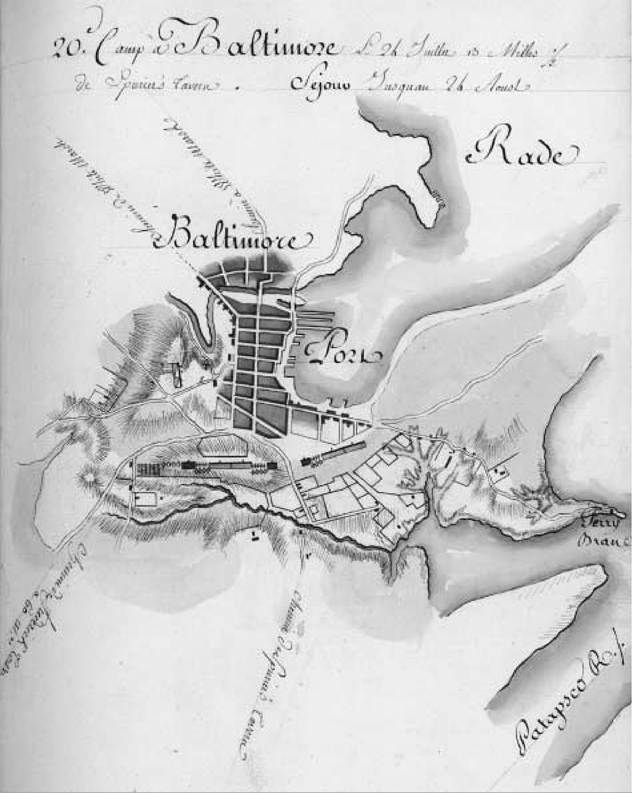
Camp à Baltimore. This ink and watercolor map of Baltimore, Maryland, was drawn in 1782 by French engineers accompanying troops under the command of the Comte de Rochambeau.
The mapping of land is essential for making legal claim to it. Maps justify, reflect, and embody deeds to land. Maps are essential for acquiring land and selling land. In May 1785, two years before the Constitution was drafted and proposed to the states, the Continental Congress passed the Land Ordinance, which covered the Northwest Territory (of the Ohio River). Its full title was "Ordinance for ascertaining the mode of disposing lands in the western territory." To sell the land, however, it first had to be surveyed. Always the mathematical rationalist, Thomas Jefferson proposed dividing the land into geographical square miles oriented north-south and east-west. A square division was simple, easily undertaken, and cheap to survey. Under the Land Ordinance and successive pieces of legislation, the land was surveyed into a rectangular grid that ran on a north-south (township) and east-west (range) system. The sheer size of the country meant that baselines had to be established; otherwise, the curvature of the earth would have caused the more northerly townships to be smaller. New baselines were established for every six to ten townships in lower latitudes and for every four to five townships in higher latitudes. Each township survey involved the compilation of field notes and the production of three manuscript maps: one copy was retained by the surveyor general, eventually becoming the property of the state; a second copy was deposited in Washington; and a third was used in the local land office. The maps in those offices became an important resource for land agents and for private sellers and buyers of land.
The very first surveys were not encouraging. Survey costs were high and receipts were disappointingly low. Better terms could be had from the private land companies. The need for revenue, however, forced the government back into the land-selling business in 1796, when the land parcel size was reduced so that in some places sections (640 acres) could be sold. Over the years the minimum size of a purchasable lot was reduced, in 1800 to a halfsection (320 acres) and four years later to a quarter-section (160 acres). This steady reduction in size, along with liberal purchasing arrangements, democratized land sales—in principle if not always in practice. The appropriation of the vast new lands of the Republic was not restricted to the rich and the few. Land was opened up to the modest and the many. In the wake of the Land Ordinance and subsequent land legislation came the greatest transfer of land in the history of the world.
Mapping was also used to settle boundary disputes between the United States and its neighbors. Jay's Treaty of 1794 was an agreement between the United States and Britain to establish commissions to settle the northwest and northeast boundaries. The former never met and the latter fixed the boundary at the Saint Croix River. Pinckney's Treaty of 1795 fixed the border between Spanish West Florida and the United States at the thirty-second parallel.
But, maps were not always accurate. Land sales in upstate New York in the 1780s to people who had fought in the Revolutionary War used maps that cited nonexistent land. Maps marked areas as Great Desert that were in fact fertile. Maps were often used but not always to be trusted.
The new Republic already had a popular geographical work, Guthrie's Geography, which was produced in England. This large text, first published in 1769, continued to be popular and appeared in successive editions until as late as 1842. However, Guthrie's Geography was written from the British perspective. The 1793 edition has a general map of North America including the United States, what became Canada, and part of Mexico. Although Canada is noted, the United States is not named. The latter is pushed up against a clearly depicted Canada and a vast wilderness beyond the Mississippi. The individual states have indistinct boundaries, with no obvious claims nor connections to the vast western lands, which have Spanish or English names. The map depicts the United States as a ragtag group of small states clustering along the eastern seaboard. It exaggerates the size of Canada and the West and shrinks the new Republic to minor significance. The map is full of Indian names, especially in the West, which is depicted as peopled and filled with potential allies and trading partners. It is not an empty wilderness ripe for U.S. expansion but a populated land, a place already inhabited.
In 1794 Mathew Carey (1760-1839), an Irish immigrant to the United States, attempted to set the record straight by publishing Guthrie's Geography with a new text, one more favorable to the new Republic. He also had new maps drawn for the book, and these subsequently formed the basis of the first proper atlases of the Republic: Carey's American Atlas, published in 1795 with twenty-one maps, and Carey's General Atlas, published in 1796 with forty-seven maps. Both Carey's American Atlas and Carey's General Atlas contained maps of the different states, bringing them all together in one volume for the first time. It is not too fanciful to suggest that both books assisted in the unification of the newly independent states, placing the emphasis more on "united" and less on "states."
A central figure in the creation of a new national geography for the United States was John Melish. Born in Scotland in 1771, he settled in Philadelphia in 1811, where he remained for the rest of his life and became an important figure in the city's vigorous book and map publishing business. He published his first large map of the United States in 1813 at a scale of one inch to one hundred miles. In 1816 Melish produced another map of the United States. At one inch to fifty miles it was a massive map. Melish was the first mapmaker to show the United States in continental context from the Atlantic to the Pacific. The map was an act of geopolitical dominance; the new Republic had found its epic cartographic representation, which was to shape and inform subsequent westward expansion. In 1820 he produced a beautifully engraved map, designed to be hung on a wall, as a public statement of a nation in the making. This map depicts the national territory as a continent full of the promise of the new West: huge, vacant, and inviting. The general statistical table, located in the bottom left of the map, lists the population then as 18,629,903, yet Melish asserts that it is capable of supporting 500 million people. This map is not only a geographical description; it is a national celebration of a nation becoming a continental power, a map reflective of continental exploration and indicative of continental expansion.