
They are used to drought; have they really thought about a fourteen-year drought?
—GINGER PAIGE, UNIVERSITY OF WYOMING ASSOCIATE PROFESSOR OF WATER RESOURCES, 20181
Perhaps the best available term is aridification, which describes a period of transition to an increasingly water scarce environment. Words such as drought and normal no longer serve us well, as we are no longer in a waiting game; we are now in a period that demands continued, decisive action on many fronts.
—COLORADO RIVER RESEARCH GROUP, MARCH 20182
Places: Platte River, central and east Wyoming; Wind River, west-central Wyoming; Green River, southwest Wyoming.
Time: 1990–2018.
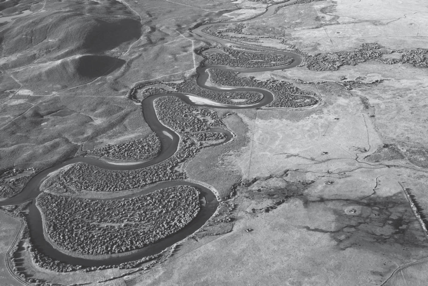
Green River and hay meadows. Courtesy of Rita Donham / Wyoming Aero Photo.
THE DEAD HAND OF the pioneer gripped April Barnes for a long time: she broke free only in 2014.
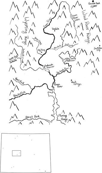
Born on a farm in Oregon in the 1990s, Barnes traveled to Colorado and then Wyoming, looking for ranch work. She found a spot in western Wyoming working as ranch hand for a woman on Fontenelle Creek. Named for an 1820s French fur trapper, Fontenelle is a Green River tributary that carries snowmelt from the Wyoming Range west of the river. In 1964, the last Bureau of Reclamation attempt at launching one more irrigation project in Wyoming created Fontenelle Reservoir, flooding a stretch of the Green River including its confluence with Fontenelle Creek. The geology was unfavorable, but the Bureau built the dam anyway; the dam nearly collapsed in its first year of operation. The irrigation project never happened. Now Fontenelle’s prime feature is the twenty-seven thousand acres of national wildlife refuge, created to make up for the loss of wildlife habitat caused by reservoirs—like Fontenelle—built in the 1950s and ’60s.3
Ranches up Fontenelle Creek, above the confluence with the Green River, were not flooded out by the reservoir. The lands had been homesteaded and irrigated in the 1870s, with settlers of the usual interesting variety. One, for instance, was a Civil War veteran and lawyer with a wife from a Kentucky abolitionist family; together the two helped keep votes for women in the new state constitution. Another Fontenelle Creek settler was a New York farm boy who spent the Civil War in California mines and married a schoolteacher after he came to Wyoming. His place eventually became the Barnes ranch. Many years later, long after Fontenelle Reservoir drowned out the lowest end of the creek, April, the young ranch hand from Oregon, met Eric Barnes “over the fence” there. Eric’s father, when just out of high school in the nearby coal mining town of Kemmerer, had been a ranch hand on the place and slowly bought it, piece by piece. It was a small ranch, with irrigated pasture in the bottom land along the creek and grazing land (for an assortment of wildlife, as well as cattle) on the benches above. Eric’s father managed to put his eight children through college from that place. Eric, the youngest, earned his college on a rodeo scholarship and was the only one to come back to the ranch. Eric was a little “wild,” April said—but eventually they got married, and together they had a son.4
April and Eric did their best to shape their irrigation as Eric’s father had taught him, to produce the best forage for their cattle. And they saw plenty of birds and wildlife: sandhill cranes, trumpeter swans, red-tailed hawks, a snow goose once; moose, bobcats, and mountain lions. Eric liked to track the cats but never allowed hunting on his place. The tracks showed that the cats never went after his calves.
To get the irrigation underway every spring, the Barneses had to get right into the roiling, icy flows of Fontenelle Creek. They jimmied telephone-pole-size logs into place to create a dam that would back up the creek enough to send water into the ditches serving the bottomland pasture. It was miserable work, and dangerous; Eric’s father was once swept downstream clinging to a log and barely made it out.
In 2014, April heard about the Wyoming office of Trout Unlimited’s Wyoming Water Project. Young men and women were working in the Green River basin, as elsewhere in the West, to help ranchers improve irrigation headgate and ditch systems to make them friendlier to both ranchers and trout. On Fontenelle Creek, April and Eric had always seen Kokanee salmon and brown and rainbow trout, and they hated to see them trapped in their ditches. They talked to Trout Unlimited staff, who came to Fontenelle Creek to assess the Barneses’ system and see what could be done.5
The new irrigation infrastructure proposed by Trout Unlimited offered ranchers in Wyoming the kind of systems many had dreamed of but could never afford. Trout Unlimited had the connections to find money to build new systems in creeks where there was good potential for a healthy trout fishery. As water commissioners for the Wyoming State Engineer’s Office can tell you, in Wyoming it used to be that you could always tell the difference between the infrastructure serving irrigation and what was built for the many oilfields scattered around the state. Oilfield pipe would be in good shape; irrigation headgates, ditches, and any occasional pipe looked patched together.
Trout Unlimited’s proposed new system for the Barnes ranch was a set of rock structures in the river and simple headgates on the main ditches. The rock structures were specially designed to keep the creek water at the ditch mouth always high enough to feed the ditch. The Barnes could access the water for irrigation when they needed by simply opening their new headgate, with a hand wheel that even their young son could operate, while standing on the bank of the ditch. No more wading in icy water trying to jockey heavy logs into place.
At the same time, the rock structures in the creek accommodated flows and fish moving downstream in a way that recognized and supported the natural dynamics of the creek. The structures were inspired by the work of an Idaho hydrologist who, when working for the US Forest Service, was so disturbed by the destruction of his hometown creeks by clear-cuts and dams that he launched a whole new approach to how people work with rivers.6
That was the beginning of a big change in the Barnes’ lives, and in their ability to keep their small ranch going.

Meanwhile, the role of the state engineer in Wyoming water management had been changing, in response to a variety of pressures.
In the mid-1990s, anxiety gripped Wyoming and reached the State Engineer’s Office. It was worry over limited prospects, fear that Wyoming would again see the kind of subsistence incomes and strapped state budgets that characterized Wyoming for most of its history. State income had become dependent on revenues from coal, oil, and natural gas, but as their market prices dropped and oil production declined, it was the end of the halcyon days of the 1970s and early 1980s, when mineral money poured into state coffers, including into water development funds. At the end of the 1990s, state officials forecast a budget deficit, and a blue-ribbon committee dared to recommend that Wyoming adopt an income tax for the first time. State income tax was anathema to Wyoming residents long used to mineral bounty.7
In the late 1990s, however, a new kind of mineral production arose that promised the kind of revenue that would save the state from seriously contemplating that step. Natural gas (methane) can be found trapped in coal seams, and a couple of laid-off oil company staffers developed a reliable and cheap way of producing it—getting enough gas from the seventy-foot thick coal seams in the Powder River basin in northeast Wyoming to make a good profit. Someone with just a water-well drilling setup could get down into unmined coal seams to get methane. By 1997, the volume of “coalbed methane” (CBM) being produced in the Powder River basin appeared to be on its way to doubling in the next year. And when final figures came in, it had done better than that.8
There were water issues associated with this minerals boom. Coal seams in the Powder River basin are aquifers, and it is water pressure that keeps the methane in the coal; to get methane out of the coal, the water must be pumped out first. From the thick coal seams in the Powder River basin, that can mean a lot of water. In 1997, Jeff Fassett, state engineer during the most contentious years of adjudicating the tribes’ rights on the Wind-Big Horn River, was still in office, and he had a decision to make on CBM. Typically, the State Engineer’s Office does not supervise oil and gas operation production of water; it’s often in small amounts, sometimes used nearby. But as CBM and its water production grew, with potential impact on groundwater supplies, Fassett decided that pumping groundwater in order to produce CBM should come under State Engineer’s Office supervision. To do that, he ruled that pumping groundwater for CBM should be considered a beneficial use of water. Some people objected to the idea that simply pumping water up to get at another resource could be considered a beneficial use of the water itself. But the alternative appeared to be letting the state agency that managed oil and gas production be the sole authority in questions of the groundwater impacts of CBM production. Instead, taking CBM water under the State Engineer’s office meant that the State Engineer’s Office could at some point choose to exercise control over the amount of water produced. The gas developers would have to get permits to use groundwater from the State Engineer’s Office, and the traditional water experts could therefore have some say in CBM development.9
After making that ruling, however, Fassett and Pat Tyrrell, who succeeded him as state engineer, delayed taking major action for several years. By 2003, CBM alone brought the state and local governments $230 million a year in tax and royalty revenues, equal to the money brought in from all other energy production combined. In 2003, CBM wells also produced what looked like a lot of water. But coalbed water production was scattered among thousands of gas wells. A state project to gather and transport the water in high volumes was studied but proved uneconomical. A large portion of the water that was produced ran down ephemeral creek drainages in the Powder River basin. The key to the boom, and the revenue, was low-cost production—an advantage that would soon evaporate, producers argued, if they were required to reinject the water or manage it for other uses.
But CBM water running in those Powder River basin drainages was not necessarily a good thing. There had never been much irrigation there, and the soils were not friendly to heavy water flows. Water produced from CBM wells varied in quality, but even decent quality water was degraded as it ran through Powder River basin soil or was stored in a small onsite reservoir. The water picked up dissolved solids, including salts. The effect on forage in the ephemeral draws and the cottonwoods they nurtured—resources the ranches depended upon for forage and shade for livestock—could be devastating. Some ranchers in the Powder River basin fought CBM; others were happy to be paid for the water damage and related losses. In an area where few water commissioners had been needed in the past, state engineer staff had to scramble to keep up with the many small reservoirs now being built for CBM water—water which the small storage sites would eventually release downstream. The State Engineer’s Office began denying permits if operators drilled before applying for a permit or failed to seek a water storage permit.
In 2007, it became clear, particularly as the industry moved westward in the basin, that more and more wells had produced water for over two years with no gas production at all—the beneficial use, gas production, was nonexistent. In late 2007, ten years after Fassett first declared that CBM water was within state engineer purview, the State Engineer’s Office began to use its permitting authority to take a role in managing the industry and its water production. State Engineer Tyrrell, in office since 2001, now required proof of adequate gas production, and he canceled permits that were producing excessive water in proportion to the gas produced. The 1909 statute explaining water rights (and imposing the transfer ban) said “beneficial use” was the basis, measure, and limit of a Wyoming water right; the word “limit” was a guard against waste. That language was still in the law. Pumping out water for little or no gas production was waste.10
As it happened, however, 2009 marked the peak of Wyoming’s CBM boom. Even during the boom, production of the gas had been only marginally economical. Another new technology, hydraulic fracturing—which began in western Wyoming’s Green River basin and spread nationwide—made prolific new gas fields accessible, spurred a gas production boom, brought gas prices down, ultimately helped dampen coal production, and killed CBM production. Tyrrell’s action on CBM had come late. As a result, many people remembered only lack of action by the state engineer at a time when water production and management in the face of CBM production was a pressing issue. Wyoming water law had developed with the understanding that water must be cared for and managed well in an arid environment where there was never enough water. Coalbed methane production, however, had presented the unfamiliar situation of too much water, and it had taken years of watching problems develop and struggling to create new policy before the state engineer took decisive action—too late for some places.11
But elsewhere, the State Engineer’s Office, joining with the Water Development Commission, found it more straightforward to adapt to other challenges and take the lead in guiding water users in adjusting to new developments. As federal policy continued to affect Wyoming water management, it was the state engineer who could best respond on behalf of water users. He was aided further by the water development office, flush with stockpiled energy income (including CBM revenues) and its influence over water users who wanted state financing for their projects. For twenty years, from the mid-1980s to the early 2000s, the engineer and the water development director were a formidable pair in shaping the impact of federal policy on Wyoming water users.
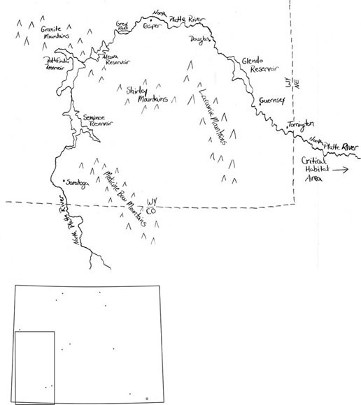
The North Platte River was a prime arena for that work. The North Platte is not Wyoming’s biggest river, but it is much in demand as it crosses the state’s eastern plains—and even more in demand next-door in Nebraska. With headwaters in Colorado mountains, the river runs north into Wyoming before taking a sharp turn to head east into Nebraska. There it joins the South Platte, also born in Colorado, to form the main Platte River, moving on to join, eventually, the Missouri River near Omaha. The Platte is a workhorse river in every state it traverses. Irrigation from the Platte was early and heavy: by 1900, over four thousand canals tapped the North, South and mainstem Platte, and the river’s summer flows weren’t enough to serve them all. Colorado’s early irrigation projects and cities, including Denver, were founded on the South Platte and its tributaries. The North Platte (along with the Shoshone River) was one of the first places that the new federal Reclamation Service chose to build a big dam. The Reclamation Service (later renamed the Bureau of Reclamation) built Pathfinder Dam west of Casper during 1905–1909. Some Wyoming acreage near the Nebraska line benefited from that project, but most of the water stored in Pathfinder went to irrigation in western Nebraska, where soil and climate was better for growing cash crops. Though the federal North Platte Project, like other federal irrigation projects in the West, eventually had most of its costs subsidized, the original Reclamation Act had envisioned the government’s investments in dams to be paid back, and Nebraska fields were the best paying proposition for Pathfinder water.12
By the 1970s, forty-nine reservoirs, federal and private, large and small, had been built in the three-state Platte basin, reservoirs capable of storing seven million acre-feet a year to serve farm fields, towns, and cities in Nebraska, Colorado, and Wyoming. Four more federal dams in Wyoming were among those dams built on the river. They helped make it possible to shift water where and when it was needed most, taking full advantage of Pathfinder’s storage, boosting the Platte-irrigated acreage in Wyoming, and eventually, in the 1990s, reducing pollution and aiding fish. The State Engineer’s Office monitored water use more heavily on the North Platte than elsewhere in the state. Disputes with the sister states (particularly Nebraska) over North Platte basin water through the twentieth century have produced stacks of legal briefs and technical documents, at a cost of tens of millions of dollars. Court decrees and settlements, determining how much water can be used where, are today enforced with satellite photography to help tote up irrigated acres and water consumption.13
Before the irrigators came and the dams were built, the Platte was a braided river—overflowing with Colorado and Wyoming mountain snowmelt in the spring and early summer and inching its way in low flows through myriad channels in late summer and fall. In Nebraska, the Central Platte stretch of river has for thousands of years been the crucial, hourglass waist of the migratory flyway for huge flocks of birds moving north toward Canada in early spring and south toward the Gulf of Mexico in the fall. Before the river was dammed and diverted, its fluctuations left it dotted with ephemeral islands and flanked by treeless wet meadows, places where birds could land and rest with good view of any predator.14
By 1970, the birds’ stopover zone on the Central Platte was estimated to receive only about 30 percent or less of the total flow of the Platte. The river’s channel had narrowed in response to the low flows. Several species of birds that relied on the river in Nebraska were at risk of extinction, US Fish and Wildlife Service scientists found, and the birds were determined “threatened” or “endangered” under the 1973 Endangered Species Act (ESA). One culprit appeared to be the radical transformation of the Platte. Dams and agriculture had tamed the old wayward river till it followed a single year-round channel lined with trees. It was no longer such a safe and welcoming resting spot for migrating birds.15
In the late 1970s, the lawsuit regarding the proposed coal-fired power plant at Wheatland was a portent of what was to come. A federal court ordered a halt to construction of the dam and reservoir being built for the plant. Federal agencies had issued a loan guarantee and a Clean Water Act permit for the project. The state of Nebraska, joined by the National Wildlife Federation and others, sued the power cooperative building the plant, invoking the Clean Water and Endangered Species Acts. In the settlement that allowed the project to be completed, the power cooperative agreed to create special water releases to the North Platte in Wyoming and a $7.5 million trust fund to maintain Platte habitat in Nebraska. Nebraska and the other plaintiffs had convinced the court that federal agencies approved the power plant without adequately analyzing impacts or consulting with the US Fish and Wildlife Service on the power plant’s planned water diversions as they would affect threatened and endangered species habitat in Nebraska.16
In the 1980s, it became increasingly clear that the ESA would have a major impact on the North Platte in Wyoming. The big dams on the North Platte in Wyoming, all run by the federal Bureau of Reclamation, faced intense scrutiny under the ESA. The law requires federal agencies to ensure that their operations or actions are unlikely to jeopardize endangered or threatened species, and the agencies must also carry out conservation programs for those species. The Fish and Wildlife Service started pushing for an evaluation of the bureau’s big dams on the North Platte in Wyoming in 1980, and proposed projects on the South Platte in Colorado were met with environmental groups’ objections because of impacts on the habitat in Nebraska. The Fish and Wildlife Service, the bureau, and the three states on the Platte—Wyoming, Colorado, and Nebraska—worked on ideas for helping habitat and allowing more water development. In 1990, the bureau finally started an official environmental impact assessment of its operations on the river.17
Meanwhile. a big non-bureau reservoir built by local irrigators in Nebraska, just past the Wyoming line, saw its federal permit for hydropower come up for renewal in 1987. Hydropower, as a significant use of the public waters, had in the early twentieth century been a focus of Progressive Era thinking like Mead’s. The thought was that use of the public water resource, impeding streams and possibly leading to a monopoly in electric power, should require a federal license and regular reviews. Hydropower projects accordingly had federal licenses with fifty-year renewal requirements. After the 1973 enactment of the ESA, any federal proposal to relicense a hydropower plant required consulting with the Fish and Wildlife Service. All that came into play in 1987 when the Nebraska irrigators’ hydropower license on the North Platte came up for renewal. Given the decades of a dwindling Platte, the Fish and Wildlife Service was critical of existing operations on the river, concluding that much more water was needed to reach habitat in the central Platte. The agency stated that proper enforcement of the ESA could require that each use, like the Nebraska irrigators’ hydropower plant, provide its own contribution to habitat improvement. Alternatively, all the users could develop a basin-wide plan to help the birds’ migratory habitat.18
One way or another, a federal connection—bureau dams, hydropower permits, federal farm loans, or canal and reservoir rights-of-way over federal lands—meant leverage on every Platte river user in Wyoming, Nebraska, and Colorado to address endangered species issues. A basin-wide approach seemed the best solution; neither individual users on a ditch nor big irrigation districts could effectively work out their own agreements with the federal government. “The ESA is the great convener and the great conciliator. Without the pressure induced by the potential power of the ESA, the states and [their] water users would have had no incentive to resolve the serious environmental issue of the degradation of the Central Platte,” recalled a senior lawyer for the Department of Interior.19
Top water officials from each state stepped up. For Wyoming, that meant State Engineer Fassett and Water Development Director Mike Purcell. The picture for Wyoming was particularly complicated by the lawsuit Nebraska had filed after the Wyoming legislature, in its enthusiasm for water development with mineral wealth, funded the $45 million dam on a North Platte tributary called Deer Creek. Some major issues on the Platte were therefore in court. The state of Nebraska had first taken Wyoming to the US Supreme Court after the drought years of the 1930s and gotten a high court decree in 1945 allocating most of the river’s flows to Nebraska. In 1986, Nebraska sued again, saying that the Deer Creek dam plan and other water uses in Wyoming violated that decree. The US Supreme Court, where such interstate suits are heard, refused to rule out considering environmental damage as part of Nebraska’s claim against Wyoming. Together, the Nebraska lawsuit and ESA review led to years of expensive litigation, and ultimately negotiation, to arrive at deals that might serve both people and wildlife on the river.20
Fassett and Purcell tried to assess and protect the needs of Wyoming irrigators from the Colorado line to Nebraska. They also had to explain Wyoming water use in the Platte basin to the other negotiators, particularly to negotiators from Nebraska. Meanwhile, the Casper-based manager of the bureau’s North Platte Project based, John Lawson, used his detailed understanding of the dams’ actual and potential operations to help work through a rethink of river management.
Since 1904, Pathfinder Dam had divided the river into two very different realms of water use. In Wyoming upstream of the dam, the gentle valleys near the Colorado line were largely the world of flood irrigation. Irrigators tapped directly into variable stream flows, resulting in intricate interdependencies among users, their flooded fields, the return flow from those fields, and the entire small water basin. Those irrigators diverted as much as they could, from a “free river” in high water times, and then diverted smaller amounts, in priority order, in the rest of the season (sometimes boosted by small private reservoirs and return flows); all of which Nebraska negotiators found hard to digest, because it was so different from what happened in their stretch of the Platte. Wyoming downstream of Pathfinder as a water-use world was more familiar to the Nebraskans. There were the towns of Casper and Douglas, the federal Kendrick project, and some private irrigation ditches, but the greatest use of water was at the far eastern edge of the state near the Nebraska line, the land of large irrigation districts much like western Nebraska. There, Wyoming irrigators used both river flows and groundwater but, like their neighbors downriver in Nebraska, depended on getting slugs of stored water delivered by the big federal dams upstream when they wanted it. Often the groundwater they pumped for sprinkler irrigation was closely tied to the river. Some of the groundwater resources had been fed by their own years of flood irrigation. Over the line in Nebraska, in fact, farmers tapped a major groundwater “mound” under their fields that their heavy use of Platte water had built up over the years.21
The Nebraska lawsuit and the ESA review of the Platte dams brought on about twenty years of back and forth to reach a workable deal and a new beginning. The two tracks of negotiation, closely related even as negotiators kept them carefully separated, wound up in 2001–2006 with a whole slew of new, interlocking management strictures and structures on the river.
In 2001, the “special master” hearing the Nebraska lawsuit for the US Supreme Court made it clear he intended to combine the two tracks, proposing to provide water for the habitat as part of his upcoming opinion deciding the interstate water rights case. That was the last thing either Wyoming or Nebraska wanted. The two states avoided it by announcing on the courthouse steps that they had reached a settlement resolving their conflict as they thought best. Both states adopted new limits on uses of surface and ground water, with some flexibility to substitute new uses for old. In Wyoming, it did mean new monitoring and reporting for the state engineer. But the Wyoming and Nebraska water experts succeeded in ensuring that it was they, rather than distant judges, who nailed down all the tricky details and set up new rules for the river. The US Supreme Court approved the settlement.22
Eventually, the river’s endangered species issues were handled under a Platte River Recovery Implementation Plan for endangered species, not finalized till 2006. Wyoming, Nebraska, and Colorado agreed under that plan to provide lands and/or cash for habitat and for new or revised water projects intended to deliver more water to the habitat area at key times. Existing dams on the river continued to operate and serve traditional users, but with some new twists to provide habitat water. The increased volume of water pledged was nowhere near what the Fish and Wildlife Service thought was necessary for the species and was more than the states wanted to deliver. Both sides, however, agreed to work in a continued cooperative effort, in stages, to see what water was really needed and what strategies helped the most. The deal thus featured an “adaptive management” approach, recognizing that initial decisions had to be made even as research was ongoing and as all sides debated the scientific conclusions. The water deliveries and habitat improvements decided on were intended to be monitored, to provide more information for future decisions.23
To oversee it all, the states created new joint management regimes for the river. There is a Decree Committee for Wyoming and Nebraska, using consensus to resolve water issues before they turn into new grudges and litigation (negotiators noted that their lawyers did not always like this idea). For the endangered species issues, Wyoming, Nebraska, and Colorado joined the federal government in a Governance Committee that includes water user and environmental group representatives. Fassett and Purcell both continued to work on getting the interlocking plans into place after they left state office; Fassett years later took a job as the head of Nebraska’s Department of Natural Resources, where he helped administer those plans from the other end of the river.24
In the end, people in all three states had to accept the reality that there could be no big new projects built to take water from streams in any part of the Platte River basin for human use. In return, negotiators were able to ensure that many existing water uses in the basin could continue even as the needs of endangered species got attention. The negotiators from all three states ensured that the risks of uses being cut back to help the Nebraska habitat were minimal and would fall where the states, not the Fish and Wildlife Service, chose. Irrigators saw their water uses largely accepted under the ESA in a way they could never have achieved if they’d had to undergo federal scrutiny individually, without state water officials taking on the negotiations.
The choices Fassett and Purcell made for Wyoming took into account the needs of the irrigators at either end of North Platte’s course through the state. Pathfinder Dam ultimately played a pivotal role in making possible Wyoming’s accommodation of the endangered species issues. Wyoming’s water contribution to the habitat came from Pathfinder—but the water development director and the state engineer, working with Lawson at the Bureau of Reclamation, came up with a clever plan for that. They managed to fit this new need, driven as it was by national environmental priorities, relatively painlessly into the operations of the big dam, local irrigation patterns, and the familiar Wyoming water-law system. The proposal was to modify the dam, making it possible in high water years to store more water. Arguably, in some years, the habitat area would get water it would have gotten anyway, but in some years, it was water that the habitat area in Nebraska would never have seen—and federal wildlife officials could control the timing for the water’s arrival. To fit into Wyoming water law, the idea was that the modification simply replaced storage space that had been lost to sediment the river had carried and piled up behind Pathfinder Dam over the century since it was built. That new storage space could have the dam’s original priority date, 1904, in Pathfinder’s case—a senior priority on the river. The water so stored would be released and shepherded down the Platte when the habitat area most needed it. Ultimately, with the Pathfinder plan, the state engineer, the Board of Control, and the Water Development Commission gave birds a water right with high priority—with Pathfinder’s 1904 date—equal to that of the users of the major federal reservoirs and the irrigators they served. The Wyoming legislature and governor approved the plan. After all, water stored under a certain priority date being delivered downstream was familiar procedure. It was much easier to accept than unilateral federal interventions changing the operation and water delivery schedules of the string of big reservoirs on the North Platte. During the litigation, Wyoming dropped its planned Deer Creek Dam, but the dam proposal provided the leverage Wyoming negotiators used to reach their goal. In the final agreement, Wyoming municipalities along the river received their own rights to a slice of the new Pathfinder storage. This amounted to about the same allotment of water they might have received from the canceled Deer Creek Dam, at a cost to the state of Wyoming of about 5 percent of the dam’s projected total cost.25
Altogether, it was quite a design feat, creating a new overarching structure of interstate and federal cooperation to govern the operations of the river—arguably important for many more Wyoming water users than the Colorado River compact had been, eighty years earlier. It was possible only through the partnership of Fassett and Purcell and their good relations with Lawson, the bureau manager in Wyoming. The years of experience those three had in water management and funding had given them intimate knowledge of federal policy and Wyoming water, water rights, water people, and water politics. They kept coming back to irrigators over the years of work, supplying themselves with local information and concerns throughout the negotiations.
The big Wyoming irrigation districts near the Nebraska line were relieved. Computer modeling based on past water flows showed that the new Pathfinder plan could reduce their water supply somewhat, sometimes. The alternative, however—unilateral federal action changing the operations of the big dams on the Platte—would have affected their water supply significantly. The modeling showed that the Pathfinder plan would most affect the Casper-area federal Kendrick Project (some of whose irrigators tended toward hobby ranching) that had 1930s water rights. The irrigation district there had major problems with selenium levels due to soils inappropriate for irrigation. Mead, in his last years at the Bureau of Reclamation, had approved the Kendrick project in 1935 despite knowledge of the selenium issue. When the twenty-first century plan was proposed for restoring Pathfinder’s capacity to take more water under its 1904 priority, the Casper-area irrigation district accepted that it might see less water as a result. The district in return received state aid in reducing selenium contamination and conserving water.26
Upstream irrigators near the Colorado line were alarmed by the new Pathfinder plan, however. The modeling showed that the impact to them would be minimal and would occur only when Pathfinder stored water before the irrigation season. But many of them had water rights later than Pathfinder’s 1904 right, and on occasion in the past they had had to cut their own water use to help fill Pathfinder. They were wary of seeing any new uses for Pathfinder water, regardless of what the modeling showed, and they didn’t completely trust the state engineer or the water development director. They saw an opportunity to block the Pathfinder plan because it required Board of Control action. The board had to approve or disapprove adding new uses—municipal, wildlife, and environmental—to the original 1904 Wyoming water right for Pathfinder. Upper river users officially objected before the board, initially arguing that the silted-in space in Pathfinder had been abandoned and could not be restored. In the end, they dropped that argument but convinced the Bureau of Reclamation and the state to agree to special protective language, which the board adopted. The special clauses provided that the new Pathfinder accounts for migratory birds and North Platte cities could not keep upper river users from tapping the North Platte any time of year.27
The birds, or their advocates, similarly wound up not quite happy. As the years went by, the habitat deal did not pan out exactly as promised for them. By 2018, the extra water that the three states managed to supply annually for the habitat amounted to less than two-thirds of what they had promised in 2006. The main problem was failure in Nebraska to build a new reservoir that had been proposed to deliver more water at specific times. This resulted in the Fish and Wildlife Service not having extra water often enough to be able to test its ideas for how to best improve habitat. Rather than insist on a new phase in the recovery program with new goals, however, in 2017–2018, the service agreed with the states to seek an extension of the program and to cut back a little the amount of extra water required. The states promised new approaches to get more water to the Central Platte—including, for Wyoming, a little more water from Pathfinder. That could affect Wyoming irrigators at both ends of the North Platte. The additional releases from Pathfinder for birds could cut down on water available for some eastern Wyoming irrigators. More releases also cut down on water available to the irrigators on the Upper Platte near the Colorado border, who were still uneasy. They harbored major doubts about how and whether the water stored in Pathfinder was really being used in Nebraska for habitat purposes, and they weren’t pleased to hear of plans for more releases from Pathfinder.28
But an extension of the program—now proposed to last till 2032—would buy all the irrigators more time to keep operating nearly as they always had, for years to come, without federal intervention. And that was what Wyoming irrigators at either end of the North Platte wanted most.
A self-described “flatlander” North Platte irrigator from eastern Wyoming—a member of the Water Development Commission—summed up the dilemma and the benefits and called for irrigator solidarity in 2018. To avoid devastation, irrigators must work together to keep both the joint state-federal habitat program and the Board of Control’s protective measure for the Upper Platte in place, he declared. “We need to stand together and say this is how it’s going to be: we’re going to protect our water rights of Wyoming and to heck with the rest of the world.” Framing that as defiance, in support of the new North Platte system, was a backhanded compliment to its architects—including the state engineer and the Board of Control.29
It was clear that pressure from the outside had forced Wyoming water users to seek protection—and accept restrictions, ultimately enforced by hi-tech monitoring tools—from the state engineer, working in partnership with the water development agency. Some of that was for the sake of a cause—distant wildlife and their habitat—that might not be an irrigator’s top goal. All in all, North Platte water users were finding themselves edging into a new water management world.
Local interest, rather than outside pressure, meant that aspects of that new world began to be explored at various scales all over the state. Streams reflect what happens in their basins, and people continued to be concerned about the condition of the streams. Over a century, irrigation had inevitably changed the volume and timing of water flows, and accordingly the shape, behavior, and content of creeks and rivers. Helping rivers to function with changed flows, so they could still handle sediment and provide good habitat as well as irrigate fields, attracted increased attention and experimentation from the 1990s into the twenty-first century. Wyoming communities—from Sheridan to Casper to Laramie, and Cheyenne to Evanston—began to see the streams flowing through their towns as quality-of-life assets they could enhance by investment. They put millions of dollars into restoring rivers—hiring expert designers and backhoe operators to create riffles and pools for fish, aesthetics, and better water quality, building streamside parks and walking paths, and trying to get more water to flow through town.30
State Engineer Fassett pulled together an ad hoc group in the 1990s to think through how more instream flows might be supported within the narrow confines of the 1986 instream flow laws. The group tried to sketch out ideas for moving and consolidating canal and diversion structures, for instance, to allow water flows to get through a town for the sake of natural beauty, water quality and recreation, before water was diverted to irrigate nearby fields. By the early 2000s, Trout Unlimited had officially opened a Wyoming office of its Western Water Project (the office that later helped the Barneses on Fontenelle) to keep streams flowing for trout. The organization cosponsored studies on Clear Creek through Buffalo and the Popo Agie River through Lander that showed how information on volumes of water diverted from a stream helps indicate aquatic health. The goal was to show what data was already readily available that could aid planning for water conservation and better instream flows. When given a chance, however, the Wyoming legislature frowned on experimentation to help stream flows. The legislature killed years of proposals from Trout Unlimited members to allow instream flows to be one of the water uses (like highway construction) to which private water rights could be temporarily changed. Advocates sought to allow water right holders to at least test out placing their water rights into instream flows, but the proposals went nowhere. The Water Development Commission refused to put money behind any town efforts in support of live rivers as a form of water development. The state engineer and the Board of Control meanwhile continued steady work adjudicating instream flow rights.31
In the tradition of Wyoming people and water, water users and administrators found other ways and funding to test how they might get water flowing where people—a town or a fishing group, for instance—wanted to see it flow. Lawson at the Bureau of Reclamation pursued a variety of ways to help Wyoming fish and fishermen. Having changed the timing of releases and storage on the North Platte to help fish spawning, he also worked with the state engineer and the Wyoming Game and Fish Department to help fish on the Shoshone. When state and federal money enlarged the Buffalo Bill Dam there, all three worked out a plan for releasing more water in winter to sustain fish. The plan was adopted in 2004 despite the resistance of the federal Shoshone Project irrigation districts that were used to thinking of the generous flows of the Shoshone River as their own—essentially a perpetual “free river” for the taking. In 2016, the Popo Agie Conservation District began what became a Healthy Rivers Initiative in Lander fostering work between ranchers, conservation groups, and town officials to adjust uses and help the Popo Agie River serve irrigation, drinking water supplies, and recreation with sufficient quantity and quality of water.32
Outside of towns, experiments with the value of water flowing in a stream went on as well. Tom Annear, who had become the state Game and Fish Department’s water management supervisor, noted that near miracles can happen when there are serious negotiations to “just add water” to a stretch of river. He slowly but steadily implemented the 1986 instream flow law and joined water right holders, including irrigation districts like Wheatland, to keep water in lakes and streams for fish. Paul Hagenstein, who had worked his family’s irrigated fields near Pinedale since the 1940s and served as a county commissioner, had initially been fiercely suspicious of introducing instream flow rights into a heavily used creek running through Pinedale. But he later decided to be the first to give an irrigation water right to the state for instream flow, when he could find no more irrigation use for it on his fields or his neighbors’. Above all, he wanted the water right to be of use to his community. Hagenstein’s gift was in 2011, twenty-five years after Wyoming’s instream flow law was passed. It marked a cultural change to acceptance of the value of instream flow, as Annear at Game and Fish commented: “I went from people calling me all kinds of names . . . to now they say, ‘Hi Tom.’ . . . From getting death threats to, now, I can’t get any attention. It’s like with every new idea—first nobody takes it seriously, they laugh at you; then they vilify you and want to kill you; and then, it’s common sense.” The legislature’s refusal to allow users to own an instream flow right themselves, however, continued to hobble landowners interested in helping streams where they lived. In other states water right markets have helped protect or move water for instream flow held by private owners, but that remained impossible in Wyoming.33
It became apparent that in water as in energy, conservation is a great untapped source of supply. In the late 1990s the Bureau of Reclamation started offering funding and requiring irrigation districts on federal projects to plan and implement conservation measures like lining dirt canals and automating their control systems. Inter-district rivalries on the bureau’s North Platte Project defeated a plan for major incentives there to use less water from the big reservoirs. But the bureau’s small Kendrick project district near Casper reduced its selenium contamination problems by using less water. Wyoming water development money went to ditch lining and other improvements, including several for the Midvale district on the Wind River, where using less water may someday help that district learn to accept the tribes’ use of their “futures” rights in the Wind River. Towns seeking state water money improved their metering and rate systems and cities like Gillette and Cheyenne plunged into water conservation, including wastewater reuse in Cheyenne.34
Conservation can present a conundrum, however, for irrigation on small creeks feeding mainstem rivers. There the conservation goal could be aiding streamflow, recreation, fish, and wildlife. Flood irrigation is common on those creeks, as it is the cheapest way to irrigate. Standard conservation measures could call from changing from flood irrigation to sprinklers or other methods that divert less water from a stream. Yet switching away from flood irrigation can increase how much water plants consume and significantly reduce return flow. Where those return flows support water tables, wetlands, and habitat, conservation may not be the best thing for the environment, nor for the downstream neighbors depending on return flow. The role of return flow in local and regional ecological and economic health generates passionate arguments for valuing return flows and flood irrigation when assessing conservation options. Economists, for their part, urge financial incentives to conserve by diverting less, and incentives have been adopted by some federal agricultural programs. Where the economics are right, moving water from a flood irrigation diversion into a pump for a sprinkler and onto a circular or semi-circular field has become common in some areas in Wyoming. Such moves often involve water right changes that come before the Board of Control. Occasionally, those involve situations that might seem to require the board to view the proposals as a change in use with impacts on return flow that must be considered, though that hasn’t happened yet. Wyoming’s community water management, formed of state agency and users, has more to do to scrutinize changes in methods of irrigation as a change in type of beneficial use. Perhaps that will help define beneficial water conservation.35
Individual ranchers have tailored new ideas for water to local conditions, coming up with changes that would help not only their operations, but fish and wildlife as well. Former state legislator Pat O’Toole, supporter of a new dam in his area, was also a strong advocate for the ecosystem benefits of flood irrigation. He worked to improve water flows for fish in small streams, and he and his wife won a national award for nature conservation work on their ranch. O’Toole’s colleague Larry Hicks heading the local conservation district got water development money to help build an elaborate series of projects to create water-cleaning wetlands, and improve stream health and fish passage, as well as rangeland improvements for livestock and wildlife. Comprehensive state studies of watersheds began to help individual ranch projects. A state engineer’s office staffer, brought on in the 1990s to help irrigators with federally mandated water conservation planning, ended up in 2002 in the water development office, running “a small water project” program that provided state-funded incentives for water conservation on private lands. To demonstrate public benefit of such a program, it was combined with a new water development program aimed at studying entire watersheds to see if local natural resources could be improved to help stabilize the environment, ranching interests, wildlife habitat and the economy of local communities. The watershed studies could determine the public benefit of small water projects and prioritize them. Though the watershed studies were dropped in priority as water development budgets tightened by 2018-19, the projects that had emerged put considerable focus on improving water quality, keeping livestock out of riparian areas which otherwise could be trampled and degraded, and finding ways to provide water in upland areas to keep livestock better distributed on the range. Those projects typically helped wildlife as well as ranchers. The State Engineer’s Office and the Board of Control kept strictly out of water quality issues except where interstate water issues were at stake; the water development office, by contrast, had gotten more involved in water quality problems.36
In the southern Big Horn basin, for instance, where sheep men and cattlemen had competed violently for range in the early twentieth century, the range had been beaten and degraded. On Kirby Creek, running west out of the Big Horn Mountains, a combination of drought, floods, and heavy grazing had caused the lower part of the creek to cut drastically down through its banks, in many places by thirty feet or more, causing the water table to drop so that it could not support much riparian vegetation, while grasses were beaten out by greasewood, of little use to browsing livestock or wildlife. In the upper end of the basin, old stock-watering reservoirs in bad shape added to erosion when they broke. The little valley looked nothing like it did in the photos taken by the first settlers. Those settlers had filed water rights with the state engineer from 1897 to 1918, but the ditches they built then sometimes could no longer reach the creek. The basin covered about two hundred square miles, mostly hilly sagebrush-grassland, and some flat valley bottom. Oil drilling, begun in 1914, occupied some creek basin lands. Starting in the late 1990s, neighbors on Kirby Creek ranches joined state and federal staff to see if and how they could change their operations and help turn things around—at least by stopping the continued down-cutting of the creek. Water quality tests showed degraded conditions in the lower stretches of the creek. The Water Development Commission funded two watershed studies to document conditions and suggest management plans, and investment of over $1.5 million in state and federal money came into Kirby Creek for such projects as stream and streambank restoration, small reservoirs, and new pipelines and stock tanks. Landowners thought they began to see results in improving water quality in the lower creek—all through voluntary action. Similar work went on all over the state.37
The improvements remained voluntary because there were no regulatory teeth. As a result of the efforts in 1980 of then-Wyoming US senator Malcolm Wallop, the regulatory reach of the federal Clean Water Act specifically excludes the water quality impacts of taking water from a creek for irrigation under state water rights. The act technically could, however, control the quality impacts of water flowing back to a stream from irrigated fields—flows that often carry sediment, and sometimes fertilizer residue as well. But those impacts were, as a practical matter, also left to voluntary efforts because of rural resistance and lack of funding for the regulatory effort that the law could require. In an extreme case, as in the town of Torrington on the North Platte federal irrigation project that extends into Nebraska, fertilizer nitrates that got into town drinking water wells violated federal standards under the Safe Drinking Water Act and pushed the town to install elaborate treatment to remove the nitrates. Management of fertilizer use in the surrounding irrigated fields remained voluntary, and local conservation districts did massive education on the topic to help keep the nitrate problem down.38
Conservation districts, post–Dust Bowl creations with local elected boards and funding, worked to keep rural water quality efforts a matter of cooperation rather than regulation. The districts became the prime vehicle for the delivery of state water development money to assess and improve watersheds and build small water projects. The conservation district at Kirby Creek managed to get a key standard for the stream downgraded, therefore easier to meet; Hicks on the Little Snake River, after he became a state senator, pressured the state water quality agency into making sure no Wyoming streams were officially identified as too degraded by irrigation diversions to achieve their best potential use. Repeated sediment releases from an old irrigation diversion dam in need of repair on the Willwood portion of the big federal Shoshone Project, culminating in a release that caused a massive fish kill on the river in 2016, have similarly been dealt with through a cooperative effort aiming to clean up sediment and set operations guidelines for the dam.39
In other states, temporary rather than permanent transfers of water rights have been increasingly highlighted as the way to juggle water to serve multiple needs, including fish and wildlife, depending on climate, demand, and economics. Wyoming’s temporary water use law from the 1950s has had considerable use in the twenty-first century, but mostly for temporarily shifting groundwater regularly used by agriculture in southeast Wyoming to oil and gas hydraulic fracturing. The temporary change-of-use law could be and was used, though rarely, to move irrigation water to small towns in a drought year. Temporary moves from one irrigated ranch to another were not possible, because the 1950s law allows temporary change only to a different type of use. The legislature’s resistance to including instream flow as a suitable new use for temporary changes quashed experimentation on that front. But it seemed possible that frustration over the time and money costs of permanent changes in water use could combine with local interest in live streams, in town and on ranches, to create a kind of pent-up demand that might eventually change how temporary and perhaps even permanent changes in water rights and water use could be handled.40
In 2005, the Wyoming legislature adopted and funded an idea that had been gathering support since the 1980s: a Wyoming Wildlife and Natural Resources Trust Fund, to put money into protecting and enhancing habitat for the state’s valuable fish and wildlife resources. Fish and wildlife, and their habitat in streams, mountains, and plains, were the assets that at bottom, as many people said, kept people living in Wyoming, foregoing the better pay they could make elsewhere. Those resources also brought in tourist dollars. The director of the new trust fund was a descendant of one of the oldest Green River ranch families, who in his own career had run both the Wyoming Stock Growers Association and a demonstration ranch of The Nature Conservancy. Ranch families, conservation districts, the state wildlife agency, and sportsmen’s non-profits brought to the trust projects they had long sought for improved habitat but could never find the funding for. The trust invested nearly $97 million and leveraged in many millions more for eight hundred projects around the state from 2006 through 2017, a quarter of which were for stream restoration or fish passage devices on existing structures in streams. The trust, and private nonprofits, funded non-development easements with ranch families to preserve open space as an alternative to zoning. The payments for such easements could often be crucial for the economic survival of ranching operations, particularly when the next generation was ready to take over. Meanwhile, Trout Unlimited, fish-focused, joined forces with the Wildlife Trust Fund, conservation districts, other non-profits, and federal and state agencies to find ranchers like April and Eric Barnes. Their money went to hire local engineers and contractors—some of whom were nearby ranchers with those skills—to build new infrastructure that would help people like the Barneses escape their outdated irrigation system and improve their ranch income, while also making it possible for fish to thrive in the creek that watered their fields.41
In the 2000s, Wyoming saw the emergence of a major new actor in both water matters and the state budget: climate change. The phenomenon stalking the twenty-first century was fueled partly from Wyoming, which since the 1970s had responded to the US demand for energy in the form most damaging for the climate long-term—coal. The wealth from taxes on production of coal and other fossil fuels had been enjoyed by everyone in the state, including towns and irrigators tapping the state water development program. It was, accordingly, hard for Wyoming people even to name the reality of climate change. Everyone from oilfield geologists to political leaders, and certainly most members of the state water development commission, initially scoffed at the idea that human activity could affect something as massive as global climate processes. But the US energy market was attuned to the impending reality even if these skeptics were not, and the market’s focus was beginning to shift. As natural gas production (much aided by hydraulic fracturing) increased and prices dropped, electric utilities eyeing price and consumer pressure moved away from coal burning to gas and some renewables. Wyoming coal production, which had grown steadily for the previous forty years, peaked in 2008 and dropped by more than 40 percent by 2019, with mines laying off employees, running through bankruptcies and mergers, or closing; even Wyoming coal-fired power plants announced plans to close units. Mineral revenues on which state budgets depended dropped by a similar amount in those years. Governors and legislators began to agonize over the budget and, as in earlier bad times, how to broaden Wyoming’s economy and revenue base. Water development funds could not meet demand for rehabilitated or new water facilities. The COVID-19 pandemic in 2020 and the accompanying further drops in oil, gas, and coal production and revenue led to major cuts in the state budget accompanied by stiff voter and legislative resistance to any discussion of new taxes.42
In daily life, as the twenty-first century came in, change in old, familiar patterns of temperature and snowfall made itself felt. Scientists at the University of Wyoming, helped by an infusion of multiyear federal grants that started in 2011 to 2013, examined more closely how water moves through Wyoming’s landscape. Ginger Paige was one of those scientists, and she expected the answers to be particularly useful in preparing Wyoming people to deal with climate change. Paige originally left her native Connecticut to pursue the challenges of hydrology in the desert Southwest. Then moving to Wyoming in the early 2000s, she joined research faculty and the extension agricultural outreach program that is part of a land grant university’s mission. She learned Wyoming politics via the hot debates surrounding the water produced in coalbed methane extraction. The workings of water in the complex geology of Wyoming, now facing the impacts of climate change, have since led her further into terrain made more difficult by politics. Her research embraces water issues from rangeland management to irrigation return flows, including how best to measure water processes and supply scientific data to the process of decision-making on water allocation.43
Wyoming’s population, small and isolated, faces an information problem, Paige says. Big-picture information like annual total river flows is available, but data for pressing water management needs—to conserve water effectively, or to adapt to climate change—have been lacking. “In Wyoming, we have for years relied on the idea of ‘no data is better than data,’ because then you didn’t know you were in trouble,” Paige said. People feared that information on how or whether water is being used could lead to attempts to declare water rights abandoned. In recent years, however, the appreciation and collection of detailed water measurements has increased, with people beginning to understand that the State Engineer’s Office needs good water information, not to scrutinize local use of water rights but to manage water in the big interstate water systems like the Platte and the Colorado. Though economic dependence on fossil fuels long kept the words “climate change” out of public discussion, information on climate and water, however, was something Wyoming people had long had an interest in. They knew too well how misunderstanding the realities of climate had shrunk the dreams of agricultural bounty in Wyoming’s past.44
In the 2000s, Wyoming did not suffer the steady, agonizing nineteen-year drought that dogged the US Southwest. In 2002 and 2003, however, nearly all of Wyoming saw a drought rated “extreme” under official national standards (with peaks to “exceptional” drought in certain times and places in the state). In 2006–2007 and 2012–2013, over half of Wyoming saw that extreme drought again. In the first extreme drought of the early 2000s, Steve Gray, a new PhD botanist put in charge of climate and water data for the state, worked diligently and courageously to find the words that would awaken Wyoming people to what climate change would mean. With snowpack and spring runoff beginning to arrive a month earlier than in the past and a clear scientific consensus on more warming ahead, people would see smaller stream flows in late summer, more reservoir water lost to evaporation, and more of Wyoming’s scant precipitation coming as rain instead of snow, Gray explained. Wyoming, so vulnerable to its dependence on water, needed careful new water management thinking to make itself less vulnerable, “regardless of the source of climate change,” he said. The water development commission’s statewide water plan, published the next year, still studiously avoided the words “climate change.” And Gray, and the climate and water data chief who preceded him in Wyoming, moved on to take climate jobs in federal agencies less averse to those two words.45
Over the next decade, however, the water development agency sought to recognize less predictable water patterns as it conducted water project planning. In 2018, even a former chairman of the Wyoming Senate committee on agriculture and of the legislative oversight committee for water development investments backed the idea that “climate science” should be included when it came to examining the water needs of a Big Horn basin watershed on his home turf. The development agency found partner states far down the Colorado River willing to commit to steadily funding the winter seeding of clouds with chemicals to cause condensation, in order to get more snow in Wyoming’s Green River headwaters, thence to run on down the river. Development staff working on dams and reservoirs used data on the driest years of the past—rather than historical “average” flows—in assessing likely water supply for proposed new reservoirs, and planning staff proposed providing more and better real-time data on water uses and streamflow to support coming decisions.46
Paige, meanwhile, has worked with graduate students on issues as local as how much water returns to a stream, and when, from a specific flood-irrigated field. That is the kind of research that can help determine, for people like the Barnes and for the State Engineer’s Office and legislators, what methods of minimizing water use can best support both agriculture and a healthy local ecology. Paige and her colleagues are also funded by major federal grants to investigate questions like exactly how snowfall or rainfall in Wyoming can be expected to “partition” itself between surface water flows and groundwater in different locations. The complex geology of “leaky watersheds” in Wyoming can send groundwater off to surprisingly distant basins, she points out, and groundwater can be an important resource for the future. People who use water in Wyoming have considerable knowledge of what they can expect to happen with surface and shallow groundwater in their local watershed, depending on everything from snowpack to their neighbors’ irrigation plans, she notes. That knowledge has been gained over the century-plus since agriculture got underway in the state. But what people know and are used to dealing with is what both they and the scientists consider “natural variability” seen for a century. It is not what scientists recognize as the “increased variability” of the past twenty years of climate change—marked by increased length and intensity of drought, variations in precipitation, and warmer temperatures. Climate scientists, who in the early 2000s thought climate change would not have a major impact on the size and severity of droughts, changed their minds about that by 2018—saying there is now a significant threat of droughts lasting ten years or more. Understanding the “partitioning” processes that determine where precipitation goes is important and not well understood in most states, Paige says. Understanding those processes in Wyoming, she says, will be crucial for water users as the climate keeps changing, so that they can manage surface and underground water locally to support their communities. “We don’t know if variability is throwing off their local knowledge points. They are used to drought; have they really thought about a fourteen-year drought? If the conditions of 2006 and 2007 lasted fourteen years?”47
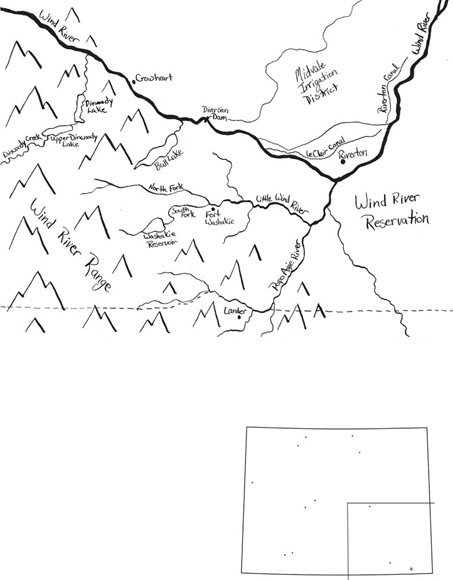
The Wind River mountain range was noticeably affected by climate change. The range is home to the largest concentration of glaciers in the entire Rocky Mountains. Photographs and measurements taken over decades showed that the glaciers in the Wind Rivers lost nearly half their area from 1900 to 2006—and almost half of that decline occurred in thirty-five years at the end of that period, with warming winter and spring temperatures a prime cause. The glaciers have in the past served as reservoirs serving the valleys at the foot of the mountains, releasing water in the late summer season after annual snows have melted. Each glacier’s share of streamflow in the creek below varies each year, ranging from nearly 11 percent to half a percent in the last half-century. As the glaciers continue to shrink, scientists warn, glaciers will contribute less to late-season streamflow, at the same time as annual snowpack in the Wind Rivers shrinks and its snowmelt runs off earlier with warmer temperatures. That combination of glacial retreat and declining, early-melt annual snowpack should mean rethinking water use through the longer summer seasons along the rivers below.48
Rethinking water use was high priority for the Wind River Water Resource Control Board on the Wind River Indian Reservation. Since the state’s lawsuit on Wind River, the tribes’ attention to water rights and management has persisted and grown, even as issues of poverty, unemployment, and health care have been top issues on the reservation. In 1991, the Office of the Tribal Water Engineer and the Control Board, both under the joint administration of the Eastern Shoshone and Northern Arapaho, were officially established through adoption of the final tribal water code. The engineer’s office has steadily built up its capacity to address water issues, often in conjunction with the Wind River Environmental Quality Commission, whose director ensured that tribal members received relevant training to work on water issues. Even in years when disagreement between the two tribes affected all tribal government and ended funding for water work, the tribal water board retained members from both tribes, and its staff wrote and won outside grants to keep operating.49
After devastating local droughts in 2012 and 2013, the Office of the Tribal Water Engineer joined federal scientists in 2015 in a study on adaptation to climate change. The largest reductions in glacier size, and the largest share they contributed to late-season flows, were estimated to be taking place not on the Colorado River side but the Wind River side of the Wind River Range—where the reservation is located. The joint tribal-federal study on the Wind River Reservation investigated what water flows the Wind River basin has seen in the past three hundred years or more. The project combined that with projections of what climate change might bring, so the tribes could assess what might happen in the Wind River basin and how they could best prepare to adapt. Native cottonwood trees, long loved and used by the Eastern Shoshone and Northern Arapaho tribes, are chronicles of water conditions. Slender core samples that can be taken without damaging the trees reveal sequences of growth rings that cover hundreds of years—narrow rings in dry years and wide ones in wet years. Scientists associated with the US Department of Interior’s North Central Climate Science Center worked with Tribal Water Engineer Office staff and University of Wyoming extension staff, tribal elders, and tribal high school students to identify good candidate trees appropriate for coring. The university meanwhile helped provide education and resources on Wind River watershed hydrology. Ultimately, the tribal water board, through the drought management plan it builds, hopes to have the data to recognize oncoming drought and manage for it. The board seeks to manage vegetation and minimize drought impact on fish and wildlife, subsistence harvesting, human health, and cultural activity.50
Where once the tribes had seemed to have a real chance to think broadly about the Wind River, the court decisions of 1989 and 1992 had in the end only hobbled tribal authority to manage water. The courts had tied tribal water use to agriculture and denied any right to control groundwater despite its interrelation with surface water. Fragmentation of their natural resource base and restrictions on its use continued to beleaguer the people on the reservation. Nonetheless, the joint tribal water board worked to build not only staff capacity in water management but the tribes’ presence in water deliberations at the statewide level. In 1989, as the court decree in the Wind River water litigation was pending, the tribes got representation on the state water development commission. State water development grants went to develop safe drinking water supplies on the reservation and rehabilitate the irrigation system; the state funds supplied a match to bring in federal funds for irrigation rehabilitation. The tribal seat on the water development commission was filled from 2006– 2014 by Mitch Cottenoir. Cottenoir grew up in Riverton and was his high school student body president; his parents had met at a Bureau of Indian Affairs boarding school in Oregon, where his mother was sent at eight years old. Getting a degree in mining engineering, Cottenoir worked in uranium and in oil and gas, creating his own company. He was pulled onto state commission jobs by two Wyoming governors and became the tribal water engineer in 2009 after serving on the tribal water board for six years. He and the board (which included Dick Baldes after he retired from US Fish and Wildlife) eventually took on a broad portfolio of work.51
Inadequate water for agriculture was the water board’s focus. Twenty-first century droughts (plus some early-season floods that destroyed irrigation infrastructure) dramatically illustrated the problem. As a lead scientist on the climate study noted, native people in the United States, and in Wyoming, are arguably the people most vulnerable to climate change, and the least empowered to adapt to it. To overcome barriers to climate adaptation, the Wind River board had to work through outside layers of power to get money and simultaneously develop on-reservation capacity to take as much control as possible of land and water.52
A major barrier was the dilapidated reservation irrigation system, a relic of decades of neglect by its official manager the federal Bureau of Indian Affairs (BIA). The Wind River irrigation project as originally designed in 1905 was never finished. The design required water storage to make water available throughout the irrigation season. Barely 20 percent of the storage capacity once planned existed in 2018. Reservation fields could be dry starting at the end of June. Since at least 1930, Congress had seen reports highlighting lack of federal funding and consequent lack of water project expertise in BIA. Since the 1960s, the BIA had sought no federal money for operations and maintenance—while never investigating what the system required or the users could afford to pay while keeping their farms and ranches going. BIA decision makers lacked technical expertise to direct any work on the project, but the agency continued to charge user fees. System maintenance was deferred over the decades, so users paid fees for water that might never make it to their fields through the dilapidated system. Without adequate water, crop quality deteriorated or land went unirrigated, and people could not pay irrigation fees. The BIA instituted some reforms, but by 2015, the number of irrigated acres per mile of canal at Wind River was under half the amount considered necessary for any irrigation project to be economically self-sufficient. While the tribes had “historic use” water rights to about 290,000 acre-feet under the Wyoming court decisions, just a little over two-thirds of that amount was being diverted to reservation fields.53
Estimates of the costs of catching up with the deferred maintenance on the Wind River project varied from $30 to $90 million. The efforts of the Office of the Tribal Water Engineer initially managed to bring in only about $11 million of that, directing it toward the most pressing problems. Wyoming senator John Barrasso, heading the Indian Affairs Committee, was able to get authorization and eventually funds in 2018 to aid rehabilitation of Wind River and other Indian irrigation projects, so there was hope of larger investment over a series of years ahead. The tribal water board meanwhile worked methodically toward the goal of taking over most of the reservation irrigation system from the BIA, as allowed by federal law. BIA staff on the ground lacked measuring equipment and had to eyeball the amounts of water diverted; discussion showed that an aggressive water user could dominate his part of the system and take whatever water he wanted. Tribal water staff, by contrast, got better training and equipment and worked alongside BIA staff to learn the infrastructure. The tribal board took over most of the system in 2019.54
By 2018, Cottenoir’s small staff did everything from monitoring water flows in the irrigation system and mediating user disputes to supervising irrigation system rehabilitation contracts and tracking changes in the use of the tribes’ 1868 “historic use” water rights. Consistent with the tribal water code, major diversions on the reservation were required to leave sufficient water in reservation streams for fish. Cottenoir’s office pulled together federal, state, and non-profit organization money to add fish ladders and fish screens to reservation facilities to support fish movement and populations. In 2018, the new Wind River Inter-Tribal Council, representing both tribes, approved an agricultural management plan that Cottenoir’s office had worked on via a series of public meetings on the reservation with university help. Under federal law, having an agricultural management plan in place would allow the tribes to set up a tribal agency that could manage agricultural resources and lands on the reservation instead of the BIA. The plan would also legally set priorities for all federal land management action on reservation agricultural land. Starting in 2014, state water development money had gone into studies to locate sites for reservoirs to serve the reservation irrigation system from the Little Wind River and its tributaries. By 2020, guidance from the tribal water board helped focus those studies to serve key reservation lands, but state water development funds fell far below what building such storage would cost. Meanwhile, Cottenoir planned to share with the state the results of the tribal-federal climate change study, covering the entire Wind River basin. 55
The Big Wind River, the river’s main stem, had been designated in the water rights lawsuit as the source to provide the water for the tribes’ futures water rights. In the thirty years since the tribes won confirmation of their water rights, they had not been able to put the futures water to use. Nothing new had happened on the Big Wind in those thirty years. Storage upstream (dreamed of by state administrations for decades before the lawsuit) could change that. The state water development commission began new storage studies in 2014 running through 2020 for the Big Wind River, with the idea of building a reservoir off the main channel to limit environmental and cultural impacts but put some futures water to work for the tribes and supply water to non-tribal districts.56
Such a reservoir was expected, by both the state water development commission and the tribal water board, to make the tribes new players on the river because the reservoir would be managed by the tribes. A reservoir might, for instance, provide water to a major proposed new tribal irrigation project, known as Riverton East, on fifteen thousand acres. Water stored for the tribes’ Riverton East project would travel down the river past the diversions on the Wind River used by Midvale and the two smaller districts. That meant water going to Riverton East could put sustained water flows where they had not been for years—exactly, in fact, in the stretch of river the tribes had tried to protect for an instream flow back in 1990.57
Meanwhile, state officials wanted to cushion the impact of the tribes’ futures water use on non-tribal irrigators. That concern had steadily motivated investment of state water development funds in conservation projects for Midvale and the two private small irrigation districts near Riverton. A new source of stored water could help more. It would particularly help the two small districts, which had no storage of their own. The Bureau of Reclamation had, because of the tribes’ futures award, made its exchange contract with the two districts only temporary, up for renewal every year.58
Climate change crosses human-made jurisdictional boundaries, and handling it requires people to reach across those boundaries. Adapting to climate change on a system as complex as an entire river basin requires genuine, continued flexibility—in infrastructure, in work across institutional boundaries, and in people. It requires cooperation, and cooperation requires trust. In the Wind River basin, with its fraught history of mutual distrust and disrespect among very different peoples, there is little trust. A big water project takes years and countless conversations and negotiations to put together. Perhaps those years, and changing attitudes toward water statewide, might someday foster enough trust among people in the basin to build a new reservoir. Perhaps nothing will come of it. Or instead, people in the basin could make way, without a big new reservoir, for the tribes to put their water rights to use the way they want.59
The Eastern Shoshone and Northern Arapaho tribes are headquartered on the Wind River, which feeds into the Missouri and Mississippi River system. But the south side of the Wind River Range (where the two tribes have no water rights) provides water to the Colorado River, and the Colorado poses its own challenge for Wyoming in an era of climate change. Nearly 20 percent of the state—about seventeen thousand square miles—is within the watershed of the Colorado River. Wyoming’s Green River meets up with the rest of the Colorado River in Utah; Wyoming’s Little Snake River feeds a tributary that joins the Green River in Utah before it meets the Colorado River. From Utah, the main stem of the river makes its way down through Nevada, Arizona, and California, whose big economies depend on the river. The growth along the lower river that had prompted concern upriver in the 1920s and made Wyoming and its neighbor headwater states join in the Colorado River Compact only picked up speed in the century that followed the compact. The river with the power to carve the Grand Canyon became so heavily used that it ended in only a dry riverbed in Mexico, where once it had built a big fertile delta on its way to the Pacific.60
The Upper Colorado River Basin Compact of 1948 allowed a certain portion of Colorado River basin water to be used in Wyoming, but people in Wyoming have never used all of that. Some had envisioned a major industrial development in southwest Wyoming, based on Green River basin coal, natural gas, and trona (a mineral that is a natural source of soda ash, used in manufacturing glass, chemicals, paper, and other materials). The mines and power plants that did flourish supported the towns of Rock Springs and Green River, but the idea of a major national-scale industrial center there seems to be dimming in the twenty-first century. Fontenelle Reservoir, built in the 1950s for irrigation that never happened, has never been used for industry.61
Starting around 2000, some nineteen years of drought dogged the mainstem Colorado River. It was estimated to be one of the worst drought cycles there in 1,200 years. High temperatures from climate change worsened the effect of low precipitation. In 2011, the Bureau of Reclamation, managing the major facilities storing and distributing water for the large economies in the Southwest, issued a dire forecast. The past century had made it clear that the 1922 compact had been based on overly optimistic numbers on how much water the river could supply. With climate change, the forecasts suggested droughts lasting five years or more could be common in the twenty-first century. Looking ahead, the bureau said that unless water use changed, continued population increase would create water demand that would increasingly exceed the limited and likely dwindling water supply. From California to Wyoming, water managers faced a major crisis, and they pushed for planning to meet the threat of long drought.62
Few stakeholders, however, think that the answer to the worsening supply-demand imbalance should be new big dams and pipes or some new centralized management for the whole river system. Rather, it has become apparent that the crisis would be met, and might be resolved, by myriad management changes—compromises, experiments, exhausting negotiations and transactions between many water users, other groups interested in water, and water managers—up and down the river. The Colorado River compacts seemed capable of proving themselves remarkably effective and flexible. In the intensifying drought, California came under more pressure from the other states and began serious work to end decades of taking more water than the 1922 compact allocated to it. In 2007, all seven compact states agreed with the federal government on guidelines for dealing with shortages and for management of levels in the key reservoirs that helped balance the needs and obligations of the upper and lower basin states.63
Despite the drought, Mexico’s water needs (quantified by a 1940s treaty) continued to be addressed, with an agreement on sharing both shortages and surpluses. Native American water rights to Colorado River water, not addressed by the compacts, got more attention, and tribes from Colorado and Utah on south that held river rights expected increasing presence in future negotiations. Environmental concerns continued to be addressed. Efforts to improve water quality in the river (including projects in Wyoming) had started in the 1970s and continued with the support of a key staffer in the Wyoming State Engineer’s Office. So had the work, assigned in Wyoming to the same staffer in the engineer’s office, to sustain endangered non-game fish on the river with money raised by imposing fees on new water development. The fish had suffered from years of dam building on the river that seriously altered the flow patterns, temperatures, and heavy sediment load of the original wild Colorado River, to which native fish were adapted. The native fish had also suffered from other human activities, from uranium tailings dumps to poisoning for the benefit of introduced game fish. In the face of the 2000s drought, the Bureau of Reclamation continued a planned series of experimental water releases designed to mimic pre-dam conditions and aid habitats in the Grand Canyon. In 2012, in continued drought, negotiators for the United States and Mexico on the Colorado undertook increased joint management efforts on the river, including five years of experimental pulses of water to occasionally renew river flows where they’d been extinguished in the Colorado River delta in Mexico.64
So in response to the severe predictions of demand far exceeding supply in a new world of climate change joined with population growth, a whole raft of water use changes, negotiated within compact bounds at a local or regional level, began to emerge and seemed to show the way ahead. Yet in 2017, Brad Udall, a major leader in climate science and water forecasts for the West, warned that despite the major efforts that had been made, people and agencies along the Colorado River were still not doing enough to deal with the risks posed by climate change.65 In 2018, after further work on the contributing causes of dropping streamflows on the Colorado, Udall and other scholars emphasized that impacts on the river will get worse, and people should give up the idea that what they see now is a “new normal” to which they had already adapted. The researchers warned:
The best available term is aridification, which describes a period of transition to an increasingly water scarce environment—an evolving new baseline around which future extreme events (droughts and floods) will occur. Aridification, not drought, is the contingency that should guide the refinement of Colorado River management practices. A very modest starting point is to admit words such as drought and normal no longer serve us well, as we are no longer in a waiting game; we are now in a period that demands continued, decisive action on many fronts.66
In Wyoming in 2005, State Engineer Pat Tyrrell launched a major effort to amass the best data possible on Wyoming’s use of water on the Green and Little Snake Rivers, to be armed to face the worst—several years of very low water levels in the big reservoirs on the Colorado River, particularly the reservoir that stores river water coming from the Upper Colorado River basin states of Wyoming, Colorado, Utah, and New Mexico. That reservoir, Lake Powell, was created in the 1960s by completion of a controversial dam that flooded beautiful and remote Glen Canyon. Lake Powell, just above the dividing point created by the Colorado River Compact between upper and lower basin states, was built to provide a “savings account” of water as insurance for the upper basin states that the lower states could receive the volume of water the 1922 compact had allocated to them without triggering a requirement for less water consumption in the upper basin. From Powell, water is released to Lake Mead, further down the river. That reservoir was created by the Hoover Dam, whose construction Elwood Mead had supervised. The lower basin states—California, Arizona, and Nevada—contract for water deliveries out of Lake Mead. In 2005, Lake Powell held only one-third the water it was built to hold. Hydropower and hydropower revenues from Powell, which helped all the upper basin states, were also at risk with low lake levels. Moreover, continued low reservoir levels could mean, under the compacts, that Arizona, Nevada, and California could invoke terms of the compact requiring upstream states like Wyoming to cut back or “curtail” their water consumption to ensure they are not responsible for depleting water flows below the levels that the 1922 compact allocated to lower basin states.67
Accordingly, the State Engineer’s Office began to invest in substantial measuring devices and data collection on Wyoming water uses on the Green and Little Snake Rivers. Wyoming was potentially in a better position than neighboring upper basin states in case of curtailment; under the rules of the 1948 Upper Colorado River Basin Compact, in a curtailment situation, each state had to cut its water use only in proportion to its past share of upper basin states’ water use. Wyoming’s uses were already low compared to use in the other states. Nonetheless, if no other preparation were made, the state engineer expected that he might have to respond to curtailment by shutting down water diversions in backward priority. That would mean shutting diversions, starting with the most recent water rights and going back in order possibly to 1922, until Wyoming reduced its water consumption by whatever amount might be required. Many Wyoming irrigation rights on the Green and Little Snake predate the 1922 compact. Those rights were unaffected by the compact and would not be shut down. But those ranches also had 1945-legislated rights to “surplus” water in spring, which helped support the use of their pre-1922 rights, helping to carry water to the fields, often through long unlined ditches. That water, and any additional spring runoff water of a “free river” that they might usually tap, would probably have to be left in streams under curtailment. Meanwhile, towns, industries, and some irrigators had later water rights, likely to be shut down if the state engineer had to respond to a call with priority regulation. The towns and industries, in turn, might then try to buy and transfer pre-1922 irrigation rights, at least temporarily—and such a water market was not welcomed by everyone. State Engineer Tyrrell was determined to be proactive and come up with a plan to handle curtailment but also possibly avoid priority regulation in Wyoming in a severely dry year on the Colorado River.68
Projections in 2018 showed that in the lower basin, where the drought had continued the longest, Lake Mead could reach unworkably low levels as early as 2020. The year 2018 was already the third driest year on record. The lower basin states were spurred into further action. Late into 2018, they worked on a Drought Contingency Plan that included requiring themselves to use less water so as to keep more in Lake Mead and adding flexibility that would encourage even further water conservation. It meant that California, for the first time, would be taking actual cuts in compact allocation rather than just slimming down its uses to match the original compact allocation. The plan could be seen as changing an element of the 1922 compact, which had become federal law by act of Congress, so they had to take the new proposal to Congress—as soon as possible. Wyoming and the other upper basin states saw a chance to hop on a now quickly moving train to get what they needed to meet the likely future. The negotiations among all seven states were complex, requiring consideration of the geography, hydrology, and economy of each very different state, much as in the original compact talks in 1922. The complicated conversations were part of a long road headed toward 2026, when the river states and the Department of the Interior expect to come up with new guidelines regarding shortages and reservoir operations.69
Wyoming, with a state engineer and lead attorney who had been in office longer than most counterparts in the upper basin, played a major part in what the negotiations achieved for the upper basin states in 2018. First, the upper basin negotiators put provisions into new formal agreements with the lower basin and the Bureau of Reclamation to ensure they would have a say in how federal reservoirs in the upper basin could be used to boost flows to Lake Mead. Second, they put into those agreements a provision that if the upper basin states decided in future to come up with ways to consume less water without being under curtailment, so more water could regularly get to Lake Powell, they could “stamp their names on” the saved water that arrived there. That meant upper basin states would have an account in Lake Powell, which they have not had before, that they could release to avoid curtailment. The states’ Upper Colorado River Compact Commission could release the water to meet any compact obligations they might have to the lower states even under those states’ new drought-restricted allocations. With such an account, Wyoming need not be forced suddenly into priority regulation: “A program like this lets us control our destiny,” Tyrrell told a public meeting in fall 2018, “and we need that.”70
From 2014 to 2018, what came up the river to Wyoming was not a curtailment demand but an experiment in voluntary cooperation. The idea was to see if water user cooperation rather than water right regulation might help upper basin states conserve water, possibly to store in Lake Powell and release downriver should the need arise. In 2014, the Bureau of Reclamation and several water supply authorities in downstream states, including Colorado and California, put together money for pilot projects testing temporary, voluntary ways to reduce consumption of water in the Colorado River. The first step was just to see if people would agree to be paid for using less water, with no attempt to measure the water or its progress downstream. Tyrrell agreed to make that pilot program available to Wyoming users, though he may have doubted its success among water users traditionally suspicious of the schemes of thirsty downstream states. Trout Unlimited, having worked with a variety of ranchers in Wyoming’s Colorado River basin in replacing or moving diversion structures, let those people know that there could be money from this new fund to pay them to stop irrigating in July and not irrigate again till fall.71
April and Eric Barnes decided to do just that. It did not change their irrigation pattern much, but it changed their lives. They had already turned off water every year in July. Now they just postponed getting water back onto the soil until October, instead of in late August or September. The big change was in the economics of their ranch. The ranch had never paid out much, and Eric had been under pressure from his brothers and sisters to sell it, which he did not want to do. From 2014 through 2018, money from the pilot project came in, and it made all the difference. The dollars provided a rainy-day fund for things they needed on the ranch and enough money to fix up a house where family members who had left the ranch could come vacation in summer. Pressure to sell the place stopped. By 2016, Wyoming matched Colorado for top participation among all the upper basin states in the pilot conservation program, with eight Green River basin pilot projects including the Barneses’. Altogether, those Wyoming irrigators had foregone use of an estimated five thousand acre-feet that year in return for total payments of a little over $1 million. There was criticism in the basin over drying up Wyoming fields in return for money from downstream states, but participation continued. In 2017, the Barneses and their neighbors—every irrigated ranch on Fontenelle Creek—took up the pilot program offer, testing how ranchers might work together to limit irrigation in an entire small watershed. Eric said he would not welcome permanent limits on irrigation on the Barneses’ place—he was concerned about what continual lack of watering in late summer and early fall would do to the soil, the groundwater, the vegetation, and the wildlife. But periodic changes in irrigation patterns, he thought, could work.72
For the Green River and Little Snake basins, an important question was where conservation should best occur so that the changing river climate wouldn’t undercut prospects for a healthy future for people and wildlife in those Wyoming valleys, where flood irrigation predominated and its return flows were important to riparian areas. Those riparian areas served both ranches and the iconic migrating wildlife herds for which western Wyoming was famous. Perhaps different places in these basins would need different kinds of attention—some forms of water conservation might be effective in some places, and support of traditional flood-irrigated fields and related wetlands would be a good idea in others. The university and non-profit organizations undertook research to explore that.73
Experts on the river estimated that the amounts of water that ranchers like the Barneses might forego using in a single year could not help Wyoming forestall curtailment. To accomplish that, water would have to be conserved and flows stored for years in the proposed new accounts for upper basin states in Lake Powell. In 2019, the State Engineer’s Office undertook an outreach effort to get every water user in the Green and Little Snake river basins to start thinking about whether it could be feasible to start a Wyoming conservation effort which, if coordinated with the other Upper Basin states into a “Demand Management Program,” might save water to be stored in Lake Powell and released by the upper basin states if necessary to forestall curtailment. The Upper Basin states had agreed that any such program would only involve water conservation that was voluntary, temporary, and compensated. How such a program could work and be paid for were among the unanswered questions.74
In Wyoming, as in other states, meetings with users to explore the implications of such an idea began. One result was generation of a mass of new data, centering not on diversions as in the past but rather on consumption of water. The 1922 compact, binding Upper Basin states not to deplete river flows, requires those states to focus on details of water consumption, whether facing curtailment or seeking conservation through demand management. The 1920s language thus pushed Wyoming and other Upper Basin states to produce specific local data on consumption, data that economists had argued could support both conservation and water markets. In Wyoming, only individuals seeking to change the use of their water rights had had to come up with such data in the past. Agreements on the North Platte had called for only cumulative basin-wide consumption figures there. Now on the Green and Little Snake, information on how much water is consumed basin-wide could be needed down to the level of individual fields and water rights, and work on generating that data got underway. The 2014–2018 pilot program that had curbed late-summer water use was not expected to be the model for demand management conservation. It had been controversial in the Upper Green River valley, where prominent people voiced “worry about drying up agriculture to wet the whistle of Denver, Salt Lake City, Phoenix and Las Vegas,” as one local rancher-legislator put it. There were calls for new high-elevation reservoirs, rather than cuts in water consumption. The Barneses and other Wyoming Green River ranch families who had participated in the pilot did, however, demonstrate that water users on the Green and the Little Snake could consider change. They could be willing to discuss whether to try to stave off curtailment, and possibly contemplate a paid conservation program to consume less water and store it.75
Two decades into the twenty-first century, Wyoming water users and water supervisors have together taken steps toward something new in their community water management system. There is statewide work on developing reliable water data and local effort to promote good stream flows and water quality. Water users retain their rights to access, use, and manage water locally; some new interests, represented by the state-held instream flow rights, have joined the water user group, and both townspeople and ranchers are interested in water for creek flows or fisheries, as well as for consumption. The major interstate negotiations concluded on the North Platte and the ongoing negotiations on the Colorado to handle climate change have given the State Engineer’s Office new experience in working on water across geographic and cultural boundaries. Perhaps that experience can even be applied on the Wind River. Meanwhile, the interstate negotiations have underlined the state’s management power over water, particularly when it comes to dealing with the demands of other states or the federal government. The state had long retained its familiar rights to include or exclude people or organizations from water rights and to decide whether and how much those rights can be transferred elsewhere. But because of challenges from outside Wyoming, the State Engineer’s Office has had to take a lead role working with users and exercising its right to manage water for public benefit. Under the pressure of changing demands, values, and climate, people can see the importance of state leadership in water, both to protect local water use and to adjust uses to meet new realities.76
After the hard days of subsistence agriculture, after the heady days of the energy boom, Wyoming people are now in an age of both inescapable climate change and the decline of a minerals-based economy. Where the economies of Wyoming and of the Wind River reservation go in such a time remains a puzzle, and many are still in denial over the hole in state revenues (as public reports and political discussion attest).77
But whatever economic life people in Wyoming work out for themselves in this century, water can help secure the fabric of that life. If the state-and-water-user community management system can continue to welcome to its circle more interests—in river flows, recreation, and water quality—then the capacity for adaptation that the community system has developed over more than a century can come back into play and help people transition, using water infrastructure that minerals funded. The independent reservation community can make its own water use choices. Meeting today’s needs, Wyoming’s two communities can manage water to support a prosperous rural life in Wyoming, with ranch country, small cities, towns and business, and a thriving landscape.