CHAPTER EIGHT
From Caen and the east – From the Caen Peripherique take the N13 towards Cherbourg. After two miles, take the Rots turning onto D86c. Drive through Rots to Bretville ‘Orgueilleuse.
From Bayeux – on the N13 towards Caen, take the turning signposted to Bretville ‘Orgueilleuse. Go through the N13 underpass (4 metre coach clearance) and turn right on the D83c towards Bretteville and Rots.
In the centre of Bretville l’Orgueilleuse turn at the traffic lights by the church onto the D83 towards St Manvieu-Norrey. Go through the underpass (the only full height crossing of the N13 in the area) and continue across the railway bridge ➊ towards Manvieu-Norrey. The railway line was the EPSOM start line. This is the area across which 44 Lowland Brigade advanced to reach St Manvieu. 6 RSF were on the left and 8 RS on the right south of Norrey. Good views from the bridge.
Follow the D83 around an S bend by a wood. Turn into a lay-by/junction on the left (on to a farm track) and park safely off the road ➋. From here, there are excellent views across the fields of the broad Mue valley unchanged since 1944. Note the tower blocks of Caen on the eastern horizon and just to the west of the city the half moon shapes of the Carpiquet Airfield hangers which were strongly held by 25 Regt Hitlerjugend. In the trees to the south, is the village of St Manvieu, which was held by 1/26 Pz Gr Regt. Looking west is the open area held by 12 SS Pioneers and the church tower of Norrey-en-Bessin.
Drive on down into the Mue valley and at the edge of the village of St Manvieux turn off the D 83 onto the D147A. The insignificant bridge by the village sign crosses the Mue, ➌ which is dry for most of the year. Drive through the new part of the village. Following the l’Affrondmentsign, turn right. The SS panzer grenadiers converted the old, stout farm buildings in this part of the village into strong points. Park by the blue NTL totem➍ in the small square in front of the church. The church, as was much of the village centre, was totally destroyed during the EPSOM fighting and the following weeks of July 1944. Continue out of the village. Turn right onto the D9 towards Fontenay-le-Pesnel.
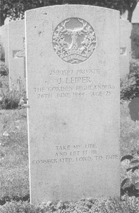
Ignoring the turnings to Cheux (pronounced Sher), park in the lay-by adjacent to the entrance to the St Manvieux Commonwealth War Graves Commission Cemetery. ➎ This is a large post-war concentration cemetery, containing 2,183 graves. A significant proportion of the dead buried here belongs to the EPSOM period. Immediately inside the entrance is a row of 10 HLI graves all dated 27 June. These soldiers were killed in the Battalion’s renewed attacks south of Cheux. There are two sizeable plots of German graves. The German headstones are without ranks but, despite the lack of rank, the ages and dates of death indicate that a significant proportion belong to the Hitlerjugend. Return to your car.
Take the turning to Cheux (D83) nearest to the cemetery. This was the main route forward for two whole divisions, until the engineers had cleared and marked the routes ‘Moon’ and ‘Star’ across country. The road through the village ➏ was choked with rubble and swept by rifle fire and mortar fire. As the volume of traffic attempting to reach the front increased and the heavy rain continued, the roads became reduced to large muddy puddles. The deadly chaos in Cheux is easily imagined.
Continue south through the rebuilt village of Cheux. Drive past a couple of paddocks and a water tower on the left. Immediately after a large stone farm, turn right onto Rue des Raux and park. ➐ This is the area, le Haut du Bosqu, 5 DCLI was occupying when Panthers of 2nd WienPanzer Division came down the road from the west and entered the orchard alongside the barn where Battalion HQ was setting up. Here the Cornishmen knocked out five of the unsupported Panthers during a close quarter battle.
Drive on south on the D83. As the road rises through the hedgerows, the area where 10 HLI fought its battles against SS-Hauptsturmführer Seigle’s panzers and assorted panzer grenadiers on the afternoon of 26 June and the morning of 27 June. Continue on to a crossroads. Turn right on to the D139 towards Rauray and Fontenay-le-Pesnel. Drive across the plateau of the Rauay Spur to the village of Rauay. At the northern edge of the village, take a right turn onto a minor road. From here ➑ the view to the north east, across the EPSOM battle area, underlines the tactical importance of the feature. With the Rauray Spur in German hands, 15th Scottish Division’s advance was always going to be difficult.
Retrace the route back to Cheux. At the cross roads in the centre of the village, near the church, turn right onto the D 89 towards Colleville and Tourville. Emerging into open country, the visitor is on the broad open plateau of Ring Contour 100 ➒. To the north, British armour congregated in the dead ground, while on the plateau itself, burnt out wrecks littered the ground. To the south, German panzers and anti-tank guns were positioned on the ridge, engaging any vehicle showing itself on Ring Contour 100. The infantry of 2 A&SH eventually forced the position. Drive on down across the Sabley stream and across the main road, which was a railwayline in 1944. Across the main road/railway, turn left onto the D89A through Colleville ➓ towards Mouen. Following the Argyles into Colleville, was 10 HLI which attacked the Leibstandarte in Mouen on 29 June. Driving into Mouen, turn left and drive across the road bridge and park ![]() Looking north across the open fields, is the ground across which 1 Worcesters delivered their successful attack on Hitler’s elite in Mouen.
Looking north across the open fields, is the ground across which 1 Worcesters delivered their successful attack on Hitler’s elite in Mouen.
Return to the village and turn left on to the D89A. It can be appreciated that the narrow roads, hedgerows and small fields were not ideal terrain for the powerful Tigers of 101 Panzer Schwere Battalion which were being used more as static pill-boxes rather than tanks. They fell prey to determined infantrymen who had, unexpectedly, attacked from the flank. 4 SLI advanced through the Worcesters to clear this area.
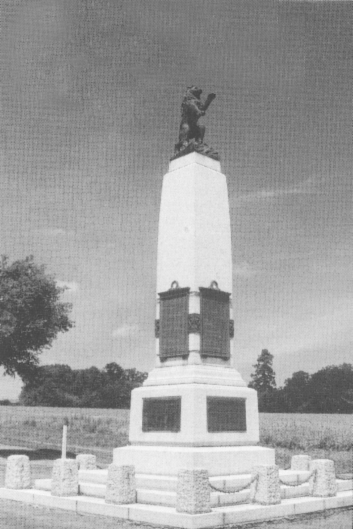
On reaching the main Caen – Villers-Bocage road (D675C), turn right. At the time of the battle this road was lightly built up along its length but today the ribbon development is much denser than it was in 1944. In Tourville, turn left onto the D89 towards Tourmauville and Esquay. On the right is 15th Scottish Division’s memorial ![]() sited to overlook the objective of the Division’s first battle, the River Odon.
sited to overlook the objective of the Division’s first battle, the River Odon.
Continue on down into the Odon Valley. This is the route taken by 2 A&SH to the Tourmauville Bridge![]() , which they seized intact on the afternoon of 27 June. The Argyles formed a tight bridgehead with three companies south of the river with one to the north but were joined by 23 Hussars after half an hour, amidst much cheering.
, which they seized intact on the afternoon of 27 June. The Argyles formed a tight bridgehead with three companies south of the river with one to the north but were joined by 23 Hussars after half an hour, amidst much cheering.
Follow the road up, out of the Odon Valley. Turn left on the D214 towards Baron. Drive through the village of Baron turn right at the statue of the Virgin and Child. Driving past a few houses the visitor breaks out into open country. Astride this Roman Road, 4 Armoured Brigade advanced up to Hill 112 on the morning of 28 June. Park by the monuments at the cross roads ![]() The monuments at the Croix des Filandriers commemorate the battle fought here by 43rd Wessex Division, supported by 31 Tank Brigade during Operation JUPITER on 10 July 1944. However, 4 Armoured Brigade suffered heavy casualties in both armour and men during 28 and 29 June, before tragically relinquishing Hill 112 to the Germans. The area was left littered with burnt out hulks of Shermans and M3 half-tracks.
The monuments at the Croix des Filandriers commemorate the battle fought here by 43rd Wessex Division, supported by 31 Tank Brigade during Operation JUPITER on 10 July 1944. However, 4 Armoured Brigade suffered heavy casualties in both armour and men during 28 and 29 June, before tragically relinquishing Hill 112 to the Germans. The area was left littered with burnt out hulks of Shermans and M3 half-tracks.
15th Scottish Division’s Memorial on the road between Tourville and the Tourmauville Bridge.
From the memorials at the Croix des Filandriers head west to le Bon Repos. Turn right after the garage onto the D89. To the left is the area where 44 RTR and 7 Kompanie 10 SS Pz Regt fought their encounter battle on 29 June ![]() Turn left onto the D214 towards Gavrus. Park by the church, which contains two British graves
Turn left onto the D214 towards Gavrus. Park by the church, which contains two British graves ![]() One is unknown and the other belongs to a Gunner Lance Sergeant Donckley who was killed in action in the village on 29 June supporting 2 A&SH. Continue through Place Royal Welch Fusiliers (who reoccupied the village in July 1944) to the main D139. Turn right and drive down into the Odon Valley and the double bridge
One is unknown and the other belongs to a Gunner Lance Sergeant Donckley who was killed in action in the village on 29 June supporting 2 A&SH. Continue through Place Royal Welch Fusiliers (who reoccupied the village in July 1944) to the main D139. Turn right and drive down into the Odon Valley and the double bridge![]() held by the Argyles for three days against the overwhelmingly powerful counter-attacks of 10th Frundsberg SS Panzer Division.
held by the Argyles for three days against the overwhelmingly powerful counter-attacks of 10th Frundsberg SS Panzer Division.
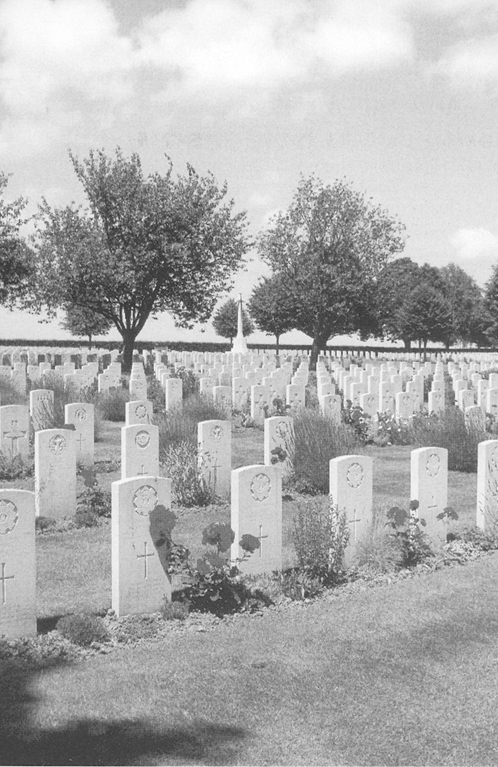
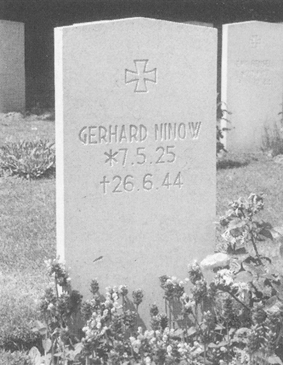
St Manvieu CWGC cemetery contains both British and German graves.
Continue on the D139, up out of the Odon Valley towards Grainville. This is the area where 46 (Highland) Brigade fought the Hohenstaufen during II SS Panzerkorps’ counter attack ![]() Cross the N175 and drive through Grainville. At the roundabout, turn left onto the Rue de Carrougesand, after several hundred yards, right onto the Rue des Trois Buttes. Looking down the drive by the white fencing, the visitor can see Chateau Grainville
Cross the N175 and drive through Grainville. At the roundabout, turn left onto the Rue de Carrougesand, after several hundred yards, right onto the Rue des Trois Buttes. Looking down the drive by the white fencing, the visitor can see Chateau Grainville ![]() the scene of the fighting on 29 June between the Royal Scots and 19 SS Pz Grs. That concludes the EPSOM tour.
the scene of the fighting on 29 June between the Royal Scots and 19 SS Pz Grs. That concludes the EPSOM tour.
Return to the roundabout. Turn left towards Tilly-sur-Seulles to return to Bayeux or right towards the N1175 to return to the Caen area.