17
![]()
The Byzantine land-walls extend from the Sea of Marmara to the Golden Horn, a total distance of about 6.5 kilometres. These walls protected Byzantium from its enemies for more than 1,000 years, and in that way profoundly influenced the history of medieval Europe. Although they are now in ruins, the walls of Byzantium are still a splendid and impressive sight, with towers and battlements marching across the hills and valleys of Thrace. Although a hike along the land-walls can be somewhat arduous, it is nevertheless quite rewarding, for on and around them we discover aspects of Stamboul which are not evident within the town itself. And in springtime this stroll can be extremely pleasant, when the walls and towers are covered with ivy, the terraces carpeted with fresh grass, and the moat colourful with wild flowers and blossoming trees.
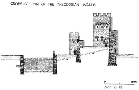
The land-walls were, for the most part, constructed during the reign of Theodosius II in the first half of the fifth century. The first phase of the Theodosian wall was completed in 413 under the direction of Anthemius, Prefect of the East. This consisted of a single wall studded with defence towers at regular intervals. However, in 447 a violent earthquake destroyed much of the wall, throwing down 57 defence towers. This happened at a very critical time, for Atilla the Hun was then advancing on Constantinople with his Golden Horde. Reconstruction of the wall began immediately under the direction of the new Prefect of the East, Constantine. The circus factions of the Hippodrome all worked together in one of their rare periods of cooperation, and within two months the walls had been rebuilt and were far stronger than before. For in addition to restoring and strengthening the original wall, Constantine added an outer wall and a moat. This stupendous achievement is commemorated by inscriptions in Latin and Greek on the Mevlevihane Gate, anciently known as the Gate of Rhegium. The Greek inscription merely gives the facts, the Latin one is more boastful; it reads: “By the command of Theodosius, Constantine erected these strong walls in less than two months. Scarcely could Pallas herself have built so strong a citadel in so short a span.” The pride is understandable, for the new defence walls saved the city from Atilla, the Scourge of God, who withdrew his forces and, instead, ravaged the western regions of the Roman Empire.
Even though they are in ruins, enough remains of the Theodosian walls to reconstruct their original plan. The main element in the defence system was the inner wall, which was about five metres thick at the base and rose to a height of 12 metres. This wall was guarded by 96 towers, 18 to 20 metres high, at an average interval of 55 metres; these were mostly square but some were polygonal. Each tower is generally divided into two floors which do not communicate with one another. The lower stories were used either for storage or for guardhouses; the upper rooms were entered from the parapet walk, which communicated by staircases with the ground and with the tops of the towers, where were placed engines for hurling missiles and Greek fire at the enemy. Between the inner and outer walls there was a terrace called the peribolos, which varied from 15 to 20 metres in breadth, and whose level was about five metres above that of the inner city. The outer wall, which was about two metres thick and 8.5 metres in height, also had 96 towers, alternating in position with those of the inner wall; in general these were either square or crescent-shaped in turn. Beyond this was an outer terrace called the parateichion, bounded on the outside by the counter-scarp of the moat which was a battlement nearly two metres high. The moat itself was originally about ten metres deep and 20 metres wide, and may have been flooded whenever the city was threatened. All-in-all it was a most formidable system of fortification – perhaps the most elaborate and unassailable ever devised. Had it not been for the invention of gunpowder and cannons these walls might never have been breached.
Most of the inner defence-wall and nearly all of its huge towers are still standing, although sieges, earthquakes and the ravages of time have left their scars. Although a few of the towers are relatively intact, most of them are split and shattered or have half-tumbled to the ground. The outer walls have been almost completely obliterated and the fragmentary remains of only about half of its towers can still be seen. Grass, bushes, vines and trees have everywhere overgrown the ruins and softened their outlines. There are little kitchen gardens and orchards flourishing in the moat and along the parateichion and the peribolos.
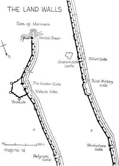
FROM THE MARBLE TOWER TO YEDİKULE
We will begin our tour in the south-western corner of the city, just beyond where we ended our last stroll in Samatya. Here the sea-walls along the Marmara joined the land-walls, anchored to them by the Marble Tower, the handsome structure which we see standing on a little promontory by the sea. This tower, 13 metres square at its base and 30 metres high, its lower half faced in marble, is unlike any other structure in the whole defence-system, and may have been part of an imperial sea-pavilion. Indeed the ruins beside it seem to indicate that it was part of a small castle. Beyond the tower there are the sunken remains of a mole which must have been part of the castle harbour.
A short way in from the shore highway, immediately to the north of the first tower of the inner wall, we see one of the ancient gateways of the city. This is called the Gate of Christ because of the laureate monogram XP above it. In the long stretch of the Theodosian walls there were only ten gates and a few small posterns. Five of the ten gates were public entryways and five were used by the military, such as the one which we see here (it was sometimes called the First Military Gate). The distinction was not so much in their structure as in the fact that while the public gates had bridges over the moat leading to the country beyond, the military gates did not, but gave access only to the fortifications. Until the end of the last century Stamboul was still a walled town and these gates were the only entryways to the city from Thrace, but in recent times the walls have been breached to permit the passage of the railway and of several modern highways. Nevertheless, nearly all the ancient city gates continue in use, as they have now for more than 15 centuries.
The first stretch of the Theodosian walls is rather difficult to inspect because of the obstacles presented by the railway and the various industries that are located here. But the stroll here is more pleasant than it was in times past, because in recent years the authorities have removed the noxious tannery that reeked here since early Ottoman times. As Evliya describes this malodorous tannery as it smelt in his time: “The overpowering reek prevents people of quality from taking up their abode here, but the residents are so used to the stench, that should they happen to meet any musk-perfumed dandy, the scent quite upsets them.”
The best route on the first part of this stroll is to walk along inside the walls from the Marmara highway as far as the railway; then, after crossing the tracks cautiously, one can walk along the highway outside the walls as far as the gate at Yedikule, where one can enter the city again.
YEDİKULE AND THE GOLDEN GATE
Yedikule, the Castle of the Seven Towers, is a curious structure, partly Byzantine and partly Turkish. The seven eponymous towers consist of four in the Theodosian wall itself, plus three additional towers built inside the walls by Mehmet the Conqueror. The three inner towers are connected together and joined to the Theodosian walls by four heavy curtain-walls, forming a five-sided enclosure. The two central towers in the Theodosian wall are marble pylons flanking the famous Golden Gate of Byzantium. The structure was never used as a castle in the usual sense, but two of the towers were used in Ottoman times as prisons; the others were used as storage places for a part of the State treasure.
To visit Yedikule we must first enter the city through a little gate just north of the castle. Though it was somewhat reconstructed in Turkish times, the Byzantine eagle above the arch on the inside proclaims its origins. This must always have been the public entrance to the city in this vicinity, as indeed it is today, for the Golden Gate itself seems to have been reserved for the emperor and for distinguished visitors and processions.
We enter Yedikule itself by a gate near the east tower; once inside the grounds we turn left to enter the tower. This is sometimes called the Tower of the Ambassadors, since in Ottoman times foreign envoys were often imprisoned there. Many of these unfortunates have carved their names and dates and tales of woe upon the walls of the tower in half a dozen languages. An inscription in French gives this advice in verse: “Prisoners, who in your misery groan in this sad place, offer your sorrows with a good heart to God and you will find them lightened.” The floors of the tower have fallen, but one climbs up by a staircase in the thickness of the wall. When at the top it is worthwhile walking around the chemin de ronde as far as the Golden Gate, for there is a fine view of the castle and the walls down to the sea, and, if it is spring, one finds a profusion of orchids, hyacinths and Roman anemones growing in the turf.
We then return to the courtyard, in the middle of which there was once a small mosque for the garrison; the remains of its minaret are still standing. We next enter the pylon to the left of the Golden Gate; this too was used as a prison and place of execution in Ottoman times. One is shown the instruments of torture and the infamous “well of blood”, a pool said to communicate with the sea, down which were supposed to have been thrown the heads of those executed here. (We do not guarantee the truth of this story.) Sultan Osman II was one of those executed here, on 22 May 1622, when he was only 17 years old. Evliya Çelebi gives this account of the execution of Young Osman, as he was called: “They carried him in a cart to Yedikule where he was barbarously treated and at last most cruelly put to death by Pehlivan (the Wrestler). Whilst his body was exposed upon a mat, Kafir Ağa cut off his right ear and a Janissary one of his fingers for the sake of a ring upon it.”
The much celebrated Golden Gate between the pylons was originally a Roman triumphal arch erected in about 390 by Theodosius I the Great. At that time the present city walls had not yet been built and the triumphal arch, as was customary, stood by itself on the Via Egnatia, about a mile outside the walls of Constantine. The arch was of the usual Roman type with a triple arcade containing a large central archway flanked by two smaller ones. The outlines of the arches can still be seen clearly although the openings were bricked up in later Byzantine times. The gates themselves were covered with gold plate – hence the name – and the façade was decorated with sculptures, the most famous of which was a bronze group of four elephants, placed there to commemorate the triumphal entry of Theodosius after his victory over Maxentius. When Theodosius II decided to extend the city two decades later, he incorporated the Golden Gate within his new land-walls. It was presumably in connection with this new wall that he built the small marble gate outside the triumphal arch; the arch itself, of course, could have had no gates, except for ornamental iron or bronze grilles, and would have been indefensible. The outer gateway is part of the general system of defence and forms, with the curtain wall which joins it to the city walls near the polygonal towers, a small courtyard in front of the Golden Gate.
After the time of Theodosius I, the Golden Gate was several times the scene of triumphal entries by victorious emperors: Heraclius in 629 after his defeat of the Persians; Constantine V, Basil I, and Basil II after their victories over the Bulgars; John I Tzimisces after his defeat of the Russians; Theophilus and his son Michael III after their victories over the Saracens. Perhaps the most emotional of all the triumphal entries was the one that occurred on 15 August 1261, when Michael VIII Palaeologus rode through the Golden Gate on a white charger after Constantinople was recaptured from the Latins. But that was the last time an Emperor of Byzantium was to ride in triumph through the Golden Gate, for the history of the Empire in its last two centuries was one of continuing defeat, and by then the gateway had been walled up for good.
YEDİKULE TO BELGRAD KAPISI
From Yedikule to the next gate, Belgrad Kapısı, it is possible to walk either on top of the great wall or on the terrace below, for the walls here are in quite good condition. All of the 11 towers which guard the inner wall in this stretch are in quite good condition, as are all but one of those in the outer wall. An inscription on the eighth tower in the inner wall records repairs by Leo III and his son Constantine V in the period 720–41, and one on the tenth tower of the outer wall notes that it was restored by John VIII Palaeologus in 1434.
We now come to Belgrad Kapısı, known in Byzantium as the Second Military Gate. This is the largest of all the military gates and in Byzantium it may have been used as a public gate, as indeed it has ever since the Conquest. The gate took its Turkish name from the fact that Süleyman the Magnificent settled in its vicinity many of the artisans he brought back with him from Belgrade after his capture of that city in 1521.
BELGRAD KAPISI TO SİLİVRİ KAPISI
The stretch of walls from Belgrad Kapısı to the next gate, Silivri Kapısı, is also in good condition, with all 13 towers still standing along the inner wall and only one missing in the outer. These towers also have inscriptions recording repairs by Leo II, Constantine V and John VIII. Silivri Kapısı is the first of the large public gates we come to when walking from the Marmara. Like all of the public gates it is double, that is with gateways through both the inner and outer walls. The most memorable day in the history of the Silivri Gate was 25 July 1261. On that day a small body of Greek troops led by Alexius Strategopoulos overpowered the Latin guards at the gate and forced their way inside, thus opening the way for the recapture of Constantinople and the restoration of the Byzantine Empire.
THE SACRED SPRING OF BALIKLI
Silivri Kapısı was known in Byzantium as the Gate of the Pege because it led to the famous shrine of the Zoodochus Pege, or the Life-Giving Spring. The shrine, known in Turkish as Balıklı Kilise, or the Church with Fish, is so called because of the fish that swim in its sacred spring; it is reached by walking out from the gate along Seyitnizam Caddesi for a short distance and veering right along Silivrikapı Balıklı Caddesi. The shrine has been popular since the early days of Byzantium, and several emperors built churches on the site; the present one dating only from 1833. The outer courtyard is particularly interesting because it is paved with old tombstones in the curious Karamanlı script, that is, Turkish written in the Greek alphabet. The inner courtyard is filled with the elaborate tombs of bishops and patriarchs of the Greek Orthodox Church. The entrance to the shrine is in the corner between the two courtyards. We descend down a long flight of steps and find ourselves in a small chapel at the west end of which is the ayazma, or sacred spring. The spring is said to be inhabited by a species of fabulous fish which are brown on one side by virtue of their ancestors having leaped from a monk’s frying-pan into the water five centuries ago, on hearing the news that Byzantium had fallen. However, closer inspection will reveal that the fish in the sacred spring have since reverted to a uniform gold.
![]()
Returning to the Silivri Gate and entering the city there, we find immediately inside a fairly large and charming mosque by Sinan. This was built in 1551 for Hadım (the Eunuch) Ibrahim Paşa, the second of the two Grand Vezirs of that name under Süleyman the Magnificent. The mosque has a fine porch with five domed bays and a portal surmounted by an elaborate stalactited baldachino. In form it is an octagon inscribed in a rectangle with galleries on each side; it has no columns but in the angles of the octagon, pretty pendentives in the form of shells support the dome. The marble mimber and sultan’s loge are of admirable workmanship, as are the panels of the doors, inlaid with ivory. Over the mihrab are tiles with inscriptions; these must be a subsequent addition, for they appear to be from the very latest Iznik period or even perhaps from the eighteenth-century potteries of Tekfur Saray. In the mosque garden is the attractive open türbe of the founder with a marble sarcophagus. The pious foundation, whose date is given in inscriptions over the garden gates, originally included a mektep and a hamam, but these have perished.
SİLİVRİ KAPISI TO MEVLEVİHANE KAPISI
Returning to the Silivri Gate we proceed along the walls, which are here not as well preserved as in the previous sections. Less than midway along there is a curious jog, or indentation, in the wall known as the Sigma from its resemblance to the uncial form of that letter – like the letter C. Just beside the Sigma is the Third Military Gate, now walled up. Over this little gate there once stood a statue of the Emperor Theodosius II, builder of these walls; it did not disappear until the fourteenth century.
Mevlevihane Kapısı takes its name from the tekke of Mevlevi dervishes which once stood outside the gate. This tekke was founded in the sixteenth century by Merkez Efendi, the son-in-law of the Sümbül Efendi whose türbe we have seen in the courtyard of Koca Mustafa Paşa Camii. In Byzantium this entryway was called the Gate of Rhegium, or sometimes the Gate of the Reds, after one of the four factions of the Hippodrome. On the south corbel of the outer gate is the inscription which we have already mentioned, recording the construction of the walls by Theodosius and the Prefect Constantine. There is also an inscription on the lintel of the outer gate which reads in part: “This tower of the Theodosian wall was restored under Justin and Sophia, our most pious sovereigns, and by Narses, the most glorius Spatharius and Sacellarius...” The emperor referred to here is Justin II, nephew and successor of Justinian the Great, who ruled from 565 till 578. The strain of his imperial duties must have been too much for poor Justin, for he ended his days in total madness, being pulled through the halls of the Great Palace in a toy cart. Narses, who succeeded Belisarius as commander of Justinian’s army conquered Totila, King of the Goths, and so saved for a time the Western Empire. Narses later became the Byzantine ruler of Italy, the last before the peninsula fell to the Lombards. He was perhaps the greatest of all the eunuchs who served Byzantium.
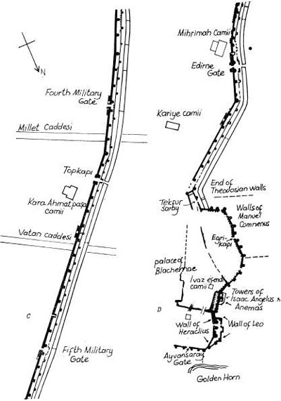
MEVLEVİHANE KAPISI TO TOPKAPI
The line of walls extending from Mevlevihane Kapısı to Topkapı, the next public gate, forms the centre of the long arc of walls between the Marmara and the Golden Horn. On the seventh tower along, where the walls extend farthest into Thrace, there is this inscription: “Oh Christ, God, preserve thy city undisturbed and free from war. Conquer the wrath of our enemies.”
Before reaching Topkapı we come to the Fourth Military Gate, now walled up, and then to the wide new breach in the walls made for the passage of Millet Caddesi. If we turn into Millet Caddesi and walk about 300 metres we come on the right to a vast bus depot. Just inside the gate of the depot there is a tiny Byzantine building known by its Turkish name, Manastir Mescidi. Its Byzantine name and its history are unknown; various identifications have been proposed, none of them with any conviction or probability. It is of the very simplest form: a long rectangular chamber ending at the east with the usual three projecting apses and preceded at the west by a small narthex with two columns. It is most probably to be dated to the thirteenth or fourteenth century.
Opposite this on the north side of Millet Caddesi is an equally insignificant little mosque called Kürekçibaşı Camii, founded by one Ahmet Bey in the reign of Süleyman the Magnificent. It is rectangular in form and with a wooden roof. It once had a fine porch of which only the columns now remain; they are Byzantine with crosses on the shaft and interesting Byzantine capitals.
We now stroll up the side street, Topkapı Caddesi, past this little mosque, and at the end of it on the left we find still another but even older mosque. This is Beyazit Ağa Camii and dates from the age of Fatih. It is of the same type as Kürekçibaşı Camii, that is, rectangular with a wooden roof, and appears to be built on top of an ancient cistern. Like the other buildings we have seen on this little detour, this is worth only a passing glance.
![]()
Opposite the end of the street on which we have been walking we come to a great mosque complex which is one of the loveliest and most masterful of the works of Sinan. It was built in 1554 for Kara Ahmet Paşa, one of Süleyman’s Grand Vezirs. We enter by a gate in the south wall into a spacious and charming courtyard shaded by plane trees. The court is formed by the cells of the medrese; to the left stands the large dershane with pretty shell-shaped pendentives under the dome; beside it a passage leads to the lavatories. The porch of the mosque has unusually wide and attractive arches supporting its five domes. Over the embrasures or niches of the porch are some rather exceptional tiles, predominantly apple-green and vivid yellow, done in the old cuerda seca technique. They are the latest recorded examples of the second period of the Iznik potteries, the only other important examples being those in the türbe of the Şehzade and the fine series of panels in the mosque of Sultan Selim. A few more such panels, but with blue and white inscriptions, will be found inside the mosque on the east wall. The marble revetment around the entrance portal evidently belongs to a restoration carried out in 1896; fortunately, though very Empire in style, it is restrained and does not clash badly with the rest.
On entering we find that the plan of the mosque is a hexagon inscribed in a rectangle. The four semidomes lie along the diagonals of the building and each rests on two small conches; six great columns support the arches, and there are galleries on three sides. The proportions of the building are unusually fine, as are many of the details; for example, the polychrome voussoirs of the arches and the elegant mihrab and mimber. But what is rarer are the wooden ceilings under the western galleries, painted with elaborate arabesques in rich reds, dark blue, gold and black. This is perhaps the most extensive and best preserved example of this kind of painting in the city; it is singularly rich and beautiful. Unfortunately, the ceiling on the left has recently been spoiled by an attempt at restoration, but the one on the right still retains its sombre brilliance.
Outside the precinct wall, towards the west, is the türbe of the founder, a simple octagonal building, unfortunately ruined inside. Beyond it stands the large mektep, double and of very interesting design, a long rectangular building with a wooden roof; it is still used as a primary school.
We now find ourselves in the large, irregular and picturesque square in front of Topkapı, the Cannon Gate. Until a few years ago, when the new breaches in the walls were made, this was one of the two main entrances to the city and, like the other one, Edirnekapı, hopelessly narrow and impossible for traffic. One pleasant result of the new breaches for the modern highways is that the districts around the ancient gates have become backwaters, to some extent, and are no longer so congested with traffic. Topkapı was anciently known as the Gate of St. Romanus, from a nearby church of that name. Its Turkish name, the Cannon Gate, comes from the fact that outside it in 1453 Sultan Mehmet placed his largest cannon, the famous Urban. Here too the Conqueror pitched his tent to direct the siege operations, which were chiefly concentrated against the stretch of walls between the Seventh and Sixth Hills. Inside the gate are suspended some of the stone cannon balls fired by Urban during the last siege.
TAKKECİ IBRAHİM AĞA CAMİİ
Before we stroll along the next stretch of walls we might take a short detour along the road that faces Topkapı and leads into the Thracian downs. After about 500 metres we see on our left an extremely picturesque mosque, Takkeci Ibrahim Ağa Camii. This is the only wooden mosque in Istanbul that appears to preserve essentially its original appearance. It is rectangular in form, with a wooden roof and porch. This is the simplest and cheapest to build and is therefore the commonest of all mosque types; but in almost all surviving examples the wooden roof and porch have succumbed to fire and have been reconstructed even more cheaply, losing thereby their charm and distinction. Doubt less because of its isolation in the country outside the walls, Takkeci Ibrahim Ağa Camii seems to have escaped the fires and has pre served its original porch and roof. It was founded in 1592 by a certain Ibrahim who was a maker of the felt hats called takke or arakiye, especially the long conical kind worn by the dervishes.
A stone wall with grilles and the remains of a fine sebil at the corner surrounds the mosque courtyard-garden. The deeply projecting wooden tiled roof of the porch is supported by a double row of wooden pillars. Since the porch extends halfway round both sides of the mosque, the pillars give the effect of a little copse of trees, the more so since the paint has long since worn off. The roof itself has three dashing gables along the façade; a very quaint and pretty arrangement. On the right rises the fine minaret with a beautiful stalactited şerefe. Handsome but rather heavy inscriptions adorn the spaces over the door and windows. Within, a wooden balcony runs round the west wall and half of the side walls; it has a cornice which preserves the original arabesque painting, such as we have just seen at Kara Ahmet Paşa Camii. The ceiling is of wood painted dark green and in the centre is a wooden dome on an octagonal cornice; one sees how greatly the dome adds to the charm of the interior and what a disaster it is when these ceilings are reconstructed flat. Two rows of windows admit light; the tiny one over the mihrab preserves some ancient, brilliant stained glass. Beneath the upper row of windows the walls are entirely revetted with tiles of the greatest period of Iznik in great panels with vases of leaves and flowers. These are celebrated and are as fine as those we have seen at Ramazan Efendi Camii.
TOPKAPI TO EDİRNEKAPI
We now return to Topkapı and resume our stroll along the walls toward Edirnekapı, the next of the Byzantine public gates. This section of the walls, anciently known as the Mesoteichion, was the most vulnerable in the whole defence system, since here the walls descend into the valley of the Lycus, which entered the city midway between the two gates. During the last siege the defenders on the Mesoteichion were at a serious disadvantage, being below the level of the Turkish guns on either side. For that reason the walls in the Lycus valley are the most badly damaged in the whole length of the fortifications: and most of the defence towers are mere piles of rubble or great shapeless hulks of masonry. It was this section of the wall which was finally breached by the Turks on the morning of 29 May 1453. The final charge was led by a giant Janissary named Hasan, who fought his way up onto one of the towers of the outer wall. Hasan himself was slain, but his companions then forced their way across the peribolos and over the inner wall into the city, and within hours Constantinople had fallen.
The course of the ancient river Lycus is today marked by the brash new Vatan Caddesi, which breaches the walls midway between Topkapı and Edirnekapı. Just inside the walls between here and the Fifth Military Gate, about 400 metres beyond, is the little neighbourhood called Sulukule, the site of a gypsy village which has been here since the fourteenth century but is now being demolished. This section of walls was anciently called the Murus Bacchatureus: according to tradition this is where the Emperor Constantine Dragases had his command post during the last siege. He was last seen there just before the walls were breached, fighting valiantly beside his cousins Theophilus Palaeologus and Don Francisco of Toledo and his faithful comrade John Dalmata. The Fifth Military Gate is known in Turkish as Hücum Kapısı, the Gate of the Assault, preserving the memory of that last battle. On the outer lintel of the gate there is an inscription recording a repair by one Pusaeus, presumably in the fifth century.
The Edirne Gate stands at the peak of the Sixth Hill and is at the highest point in the city, 77 metres above sea-level. This gate has preserved in Turkish form one of its ancient names, Porta Adrianople, for from here started the main road to Adrianople, the modern Edirne. It was also known in Byzantium as the Gate of Charisius or sometimes as the Porta Polyandrium, the Gate of the Cemetery. This latter name undoubtedly came from the fact that there was a large necropolis outside the walls at this point. Several ancient funerary steles from this necropolis can still be seen set into the courtyard wall of the Greek church of St. George, which stands just inside the walls near the gate.
It was through the Edirne Gate that Sultan Mehmet II made his triumphal entry into the city on 29 May 1453, and a modern plaque beside the gate commemorates this event. Evliya Çelebi, whose ancestor Yavuz Ersinan was present at the time, gives this vivid description of that historic moment: “The Sultan then having the pontifical turban on his head and sky-blue boots on his feet, mounted on a mule and bearing the sword of Mohammed in his hand, marched in at the head of seventy or eighty thousand Moslem heroes, crying out ‘Halt not conquerors! God be praised! Ye are the conquerors of Constantinople!’ ”
MİHRİMAH CAMİİ
Just inside the Edirne Gate to the south stands the magnificent mosque of Mihrimah Sultan, which dominates the Sixth Hill and can be seen for miles about in all directions. It is one of the architectural masterpieces of the great Sinan, built by him for the Princess Mihrimah, the favourite daughter of Süleyman the Magnificent. The külliye was built between 1562 and 1565 and includes, besides the mosque, a medrese, a mektep, a türbe, a double hamam, and a long row of shops in the substructure of the terrace on which it is built. Unfortunately the complex has been very severely damaged by earthquakes at least twice, in 1766 and 1894. Each time the mosque itself was restored but the attendant buildings were for the most part neglected; in recent years some not altogether satisfactory reconstruction has been carried out.
We enter from the main street through a gate giving access to a short flight of steps leading up to the terrace. On the right is the great courtyard, around three sides of which are the porticoes and cells of the medrese. The west side, which stands just opposite the Theodosian walls with only a narrow road between, has only had its portico restored, and it is difficult to be sure how many cells there were along this side and whether the dershane stood here as one might expect. In the centre of the courtyard is an attractive şadırvan. The mosque is preceded by an imposing porch of seven domed bays supported by eight marble and granite columns. This porch was originally preceded by another, doubtless with a sloping wooden roof supported on 12 columns, traces of which may be seen on the ground. This double porch was a favourite device of Sinan’s, found again at Mihrimah’s other mosque at Üsküdar and in many others.
The central area of the interior is square, covered by a great dome 20 metres in diameter and 37 metres high under the crown, resting on smooth pendentives. The tympana of all four dome arches are filled with three rows of windows. To north and south high triple arcades, each supported on two great granite columns, open into side aisles with galleries above, each of three domed bays; but these galleries reach only to the springing of the dome arches. The plan thus gives a sense of enormous space and light. Altogether Mihrimah Camii is one of the very finest mosques in the city and must be counted as one of Sinan’s masterpieces. It is curious that this mosque, although imperial, has but one minaret, while Mihrimah’s other mosque in Üsküdar has two.
The interior stencil decoration is modern, insipid in colour and characterless in design. The mimber, however, is a fine original work of white marble with a beautiful medallion perforated like an iron grille. The voussoirs of the gallery arches are fretted polychrome of verd antique and Proconnesian marble.
From the exterior the building is strong and dominant as befits its position at the highest point of the city. The square of the dome base with its multi-windowed tympana, identical on all sides, is given solidity and boldness by the four great, weight-towers at the corners, prolongations of the piers that support the dome arches. Above this square rises the dome itself on a circular drum pierced by windows.
If we walk around to the south side of the mosque, we find a small graveyard at the end of which stands an unusually large sibyan mektebi with a central dome flanked by two cradle-vaults. Beyond this and entered through it is the türbe of the Grand Vezir Güzelce Ahmet Paşa, Mihrimah’s son-in-law. (Mihrimah herself is buried in her fathers türbe at the Süleymaniye.) Ahmet Paşa’s türbe is like only one other built by Sinan, that of Pertev Paşa at Eyüp. It is rectangular, more than twice as long as it is wide, covered by a large dome and two cradle-vaults. A third example of a classical türbe of this form is that of Destari Mustafa Paşa at the Şehzade. Ahmet Paşa’s türbe contains a large number of sarcophagi of members of the family of Princess Mihrimah, many of them children.
On the north-east side of the mosque, entered from the main street, we see the double hamam of the foundation which has recently been restored. There is nothing unusual about the plan of this hamam: the eyvans of the hararet have semidomes, the hücre domes are on simple pendentives, and the entrance is, as often, off-centre through one of the hücres. At the corner of the hamam is a simple but attractive çeşme.
EDİRNEKAPI TO TEKFUR SARAY
The Theodosian walls continue for about 600 metres beyond the Edirne Gate; the inner wall in this stretch is well preserved and has nine towers which are more or less intact. (The remaining stretch of walls leading down to the Golden Horn was built in later times, from about the seventh to the twelfth century.) At the very end of the existing Theodosian wall, just next to the last tower in the inner wall, is the site of a small portal which played a fateful role in the last siege. This is the Porta Xylokerkou, the Gate of the Wooden Circus, named after a hippodrome which once stood outside the walls in this area. It was through here that the Janissaries first made their way into the city. And it was from the tower beside the Porta Xylokerkou, the very last bastion on the long line of the Theodosian walls, that the Turkish ensign first waved over this city.
TEKFUR SARAY
Just beyond the site of this gate there stands one of the most remarkable buildings remaining from the days of Byzantium. It is known in Turkish as Tekfur Saray, or the Palace of the Sovereign, though it is sometimes called the Palace of the Porphyrogenitus. The palace was probably built in the latter part of the thirteenth or early in the fourteenth century, and served as one of the imperial residences during the last two centuries of the Empire: it was perhaps an annexe of the nearby Palace of Blachernae. It is a large three-storeyed building wedged in between the inner and outer walls of the last stretch of the Theodosian fortifications. On the ground floor an arcade with four wide arches opens onto the courtyard, which is overlooked on the first floor by five large windows. The top floor, which projects above the walls, has windows on all sides, seven overlooking the courtyard, a curious bow-like apse on the opposite side, and a window with the remains of a balcony to the east. The roof and all the floors have disappeared. The whole palace, but especially the façade on the court, is elaborately decorated with geometrical designs in red brick and white marble so typical of the later period of Byzantine architecture; compare the façades of St. Saviour in Chora and of St. Theodore, both of the fourteenth century.
After the Conquest the palace was used for a variety of purposes. During the sixteenth and seventeenth centuries it was used as a menagerie, particularly for larger and tamer animals such as elephants and giraffes. (The latter animal particularly amazed European travellers, for they had never seen one before. In 1597, Fynes Moryson describes it thus: “a beaste newly brought out of Affricke, (the Mother of Monsters) which beaste is altogether unknowne in our parts, he many times put his nose in my necke, when I thought my selfe furthest distant from him, which familiarity I liked not; and howsoever his Keepers assured me he would not hurt me, yet I avoided those his familiar kisses as much as I could.”) Before the end of the seventeenth century the animals were moved elsewhere and the palace served for a while as a brothel. But it was soon redeemed from this misuse; for in 1719 there was set up here the famous Tekfur Saray pottery. This works produced a new kind of Turkish tile, the so-called Tekfur Saray type, inferior indeed to those of Iznik and beginning to show European influence, but nevertheless quite charming. The project, however, was short-lived and by the second half of the eighteenth century the palace was in full decline and finally lost its roof and floors. During the first half of the nineteenth century Tekfur Saray served as a poorhouse for the indigent Jews of Stamboul. About 1860, the American missionary Cyrus Hamlin, searching for a site for the future Robert College, seriously considered purchasing the palace and restoring it for use as an educational institution; perhaps fortunately, the idea was abandoned in favour of the present site of the College (now Boğaziçi University) on the Bosphorus. In recent years the palace has served as a bottle works and storehouse – the lamentable history of a palace down on its luck. The building is now a mere shell; but in recent years the surviving structure has been well restored.
Just beyond Tekfur Saray the Theodosian wall comes to an abrupt end, and from there the fortifications are continued by walls of later construction. There has been much discussion about the original course of the Theodosian walls from Tekfur Saray down to the Golden Horn. It would appear that they turned almost due north at Tekfur Saray and from there followed a more or less straight line down to the Horn, whereas the present walls are bent in an arc farther out into Thrace. Stretches of what are undoubtedly the original Theodosian wall can be seen at Tekfur Saray and also along Mumhane Caddesi, which we reach by turning right in the little square beyond the palace and then taking the first left. The ruined walls along this street are quite impressive and picturesque.
The present stretch of walls from Tekfur Saray to the Golden Horn is quite different from the Theodosian fortifications. It is a single bulwark without a moat; to make up for this deficiency it is thicker and more massive than the main Theodosian wall and its towers are stronger, higher and closer together. The part of the wall that encloses the western bulge between Tekfur Saray and the Blachernae terrace can be fairly well inspected if we follow the street closest to the wall and walk through the gardens of the intervening houses.
WALL OF MANUEL COMNENUS
The first part of this section of the walls was built by the Emperor Manuel Comnenus (r. 1143–80). This wall begins just beyond Tekfur Saray, where it starts westward almost at right angles to the last fragment of the Theodosian wall, then turning north at the third tower. The wall of Manuel is an admirably constructed fortification consisting of high arches closed on the outer face and containing nine towers and one public gate, now called Eğri Kapı. Most authorities identify Eğri Kapı with the ancient Gate of the Kaligaria. It was here that Constantine Dragases was last seen alive by his friend, George Phrantzes, who would later write a history of the fall of Byzantium. On the night of 28 May 1453 the Emperor, accompanied by Phrantzes, had stopped briefly at the Palace of Blachernae after returning from his last visit to Haghia Sophia.
According to Phrantzes, Constantine assembled the members of his household and said goodbye to each of them in turn, asking their forgiveness for any unkindness he might ever have shown them. “Who could describe the tears and groans in the palace?” Phrantzes wrote, “Even a man of wood or stone could not help weeping.” The Emperor then left the Palace and rode with Phrantzes down to the Gate of the Kaligaria. They dismounted there and Phrantzes waited while Constantine ascended one of the towers nearby, whence he could hear the sounds of the Turkish army preparing for the final assault. After about an hour he returned and mounted his horse once again. George Phrantzes then said goodbye to Constantine for the last time and then watched as the Emperor rode off to his post on the Murus Bacchatureus, where he met his death the following morning in defence of his doomed city.
Eğri Kapı, the Crooked Gate, is so-called because the narrow lane which enters the city there must detour around a türbe which stands almost directly in front of the gate. This is the supposed tomb of Hazret Hafız, a companion of the Prophet, who, according to tradition, was killed on this spot during the first Arab assault on the city. Several sainted Arab heroes of that campaign are buried in the vicinity, all having been violently dispatched to paradise by the defenders on the walls of Byzantium. The burial place of Hazret Hafız was only ‘discovered’ in the eighteenth century by the Chief Eunuch Beşir Ağa, who thereupon built this türbe, thus blocking the road.
From Eğri Kapı we continue along the path just inside the walls to see the remainder of the wall of Manuel Comnenus, which ends at the third tower past the gate. The rest of this section of wall, from the third tower to where it joins the retaining wall of the Blachernae terrace, appears to be of later construction. The workmanship here is much inferior to that of Manuel’s section, as can clearly be seen where the two join, without being bonded together, just beyond the third tower from Eğri Kapı. This section contains four towers, all square and also much inferior to those built by Manuel. Manuel’s wall bears no dated inscription; the northern and later one has three: one dated 1188 (Isaac II Angelus), another 1317 (Andronicus II Palaeologus), and the third 1441 (John VIII Palaeologus). There is also in this northern section a postern, now walled up, which is thought to be the ancient Gyrolimne Gate. This was an entryway to the Palace of Blachernae, whose outer retaining wall and two towers continue the line of fortifications in this area.
WALLS OF LEO AND HERACLİUS
The fortification from the north corner of the Blachernae terrace to the Golden Horn consists of two parallel walls joined at their two ends to form a kind of citadel. The inner wall was built by the Emperor Heraclius in 627 apparently in an attempt to strengthen the defences in this area, which the year before had been breached by the Avars. The three hexagonal defence towers in this short stretch of wall are perhaps the finest in the whole defence system. In 813 the Emperor Leo V decided that this wall by itself was inadequate and therefore added to it the outer wall, protected by four small towers. (The city was then being threatened by Krum of the Bulgars.) However, Leo’s wall is thin and much inferior to the older one behind it. These walls were pierced by a single entryway, the Gate of the Blachernae; that part of the gate which passed through the wall of Leo has now collapsed but it is still open through the Heraclian wall, passing between the first and second towers.
The citadel between the walls of Leo and Heraclius is in its own peculiar way quite fascinating. At one end of the citadel there is a small Muslim graveyard which contains the graves of Ebu Şeybet ül-Hudri and Hamd ül-Ensari, two other martyred Companions of the Prophet. We find here also the türbe of Toklu Dade, the Muslim saint who would seem to be the reincarnation of St. Theca, whose church just outside the citadel became Toklu Dede Mescidi when it was converted into a mosque.
At the northern corner of the citadel the walls of Leo and Heraclius come together and there link up with the sea-walls along the Golden Horn. This, then, is the end of our tour. We leave the citadel through the Gate of the Blachernae and turn left on the street outside, Toklu Dede Sokağı, down which we walked on a previous tour. This brings us out to the main road along the Golden Horn, where we finish our long stroll along the land-walls.