
19
![]()
Visitors to Istanbul sometimes forget that an important part of the city is located in another continent, across the way in Asia. The most interesting of these Anatolian suburbs from the point of view of historical monuments is Üsküdar, which lies directly opposite the mouth of the Golden Horn.
Üsküdar was anciently known as Chrysopolis, the City of Gold, founded by the Athenians under Alcibiades in 409 B.C. Chrysopolis was in antiquity a suburb of the neighbouring and more important town of Chalcedon, the modern Kadıköy, now itself a suburb of the great city across the strait. According to tradition, Chalcedon was founded in about 687 B.C., two decades before the original settlement of Byzantium. Chrysopolis, because of its fine natural harbour and its strategic location at the head of the strait, began to develop rapidly and later surpassed Chalcedon in size and importance. Chrysopolis became the starting place for the great Roman roads which led from Byzantium into Asia and was a convenient jumping-off place for military and commercial expeditions into Anatolia. Throughout the Byzantine period it was a suburb of Constantinople and thus had much the same history as the capital. Its site was not well-suited for defence, however, and it was on several occasions occupied and destroyed by invading armies while Constantinople remained safe behind its great walls. For this reason there are no monuments from the Byzantine period remaining there. The town was taken by the Turks in the middle of the fourteenth century, more than 100 years before the fall of Constantinople. (The Byzantine name Scutari, of which the modern Turkish Üsküdar is merely a corruption, dates from the twelfth century and derives from the imperial palace of Scutarion, which was at the point of land near Leander’s Tower. This has vanished, as have all other traces of Byzantine Chrysopolis.)
During the Ottoman Empire several members of the royal family, particularly the Sultan Valides, adorned Üsküdar with splendid mosques and pious foundations, most of which are still to be seen there today. Many great and wealthy Osmanlıs built their mosques, palaces and konaks there too, preferring the quieter and more serene environment of Üsküdar to the tumult of Stamboul. Time was, and not so long ago either, when Üsküdar had a charmingly rustic and rural atmosphere reminiscent of Ottoman days. Traces of this still remain, although modern progress is fast destroying old Üsküdar, as it is so much else in this lovely city.
We can reach Üsküdar either by passenger ferry from the Galata Bridge or by the smaller boats from Kabataş on the European shore of the lower Bosphorus. Either way we land at the iskele beside Iskele Meydanı, the great seaside square of Üsküdar, much of which occupies the site of the ancient harbour of Chrysopolis. In Ottoman days it was known as the Square of the Falconers and was the rallying place for the Sürre-i-Hümayun, the Sacred Caravan that departed for Mecca and Medina each year with its long train of pilgrims and its sacred white camel bearing gifts from the Sultan to the Şerif of Mecca.
ISKELE CAMİİ
The ferry-landing is dominated on the left by a stately mosque on a high terrace; it takes its name, Iskele Camii, from the ferry-landing itself. The mosque was built in 1547–8 by Sinan for Mihrimah Sultan, daughter of Süleyman the Magnificent and wife of the Grand Vezir Rüstem Paşa. The exterior is very imposing because of its dominant position high above the square and its great double porch, a curious projection from which covers a charming fountain. The interior is perhaps less satisfactory, for the central dome is supported by three instead of the usual two or four semidomes; this gives a rather truncated appearance which is not improved by the universal gloom. Perhaps it was the gloominess of this building which made Mihrimah insist on floods of light when, much later, she got Sinan to build her another mosque at the Edirne Gate. Of the other buildings of the külliye the medrese is to the north, a pretty building of the rectangular type, now used as a clinic; the primary school is behind the mosque built on sharply rising ground so that it has very picturesque supporting arches; it is now a children’s library. On leaving the mosque terrace one finds at the foot of the steps the very handsome baroque fountain of Ahmet III, dated 1726.
Passing the fountain and entering the main street of Üsküdar we soon come on the left to a supermarket housed in the remains of an ancient hamam. The owner calls it Sinan Hamam Çarşısı, thus ascribing the bath to Sinan; this is probably not so though it certainly belongs to his time. It was a double hamam, but the main entrance chambers were destroyed when the street was widened.
A little farther on is an ancient and curious mosque built by Nişancı Kara Davut Paşa towards the end of the fifteenth century. It is a broad, shallow room divided into three sections by arches, each section having a dome, an arrangement unique in Istanbul.
YENİ VALİDE CAMİİ
Across the street and opening into the square is the large complex of Yeni Valide Camii, built between 1708 and 1710 by Ahmet III and dedicated to his mother the Valide Rabia Gülnüş Ümmetullah. At the corner is the Valides charming open türbe like a large aviary, and next to it a grand sebil. On entering by the gate from the square one sees a very attractive wooden façade, a later addition, which is the entrance to the imperial loge. The mosque itself is in the classical style at its very last gasp and before the baroque influence had come to liven it up; it is a variation of the octagon-in-square theme; the tiles are late and insipid. Walking through the outer courtyard one comes to the main gate, over which is the mektep, and outside the gate stands the large imaret with a later, fully baroque, çeşme at the corner.
![]()
Taking the street opposite the main gate and turning left, then right, one reaches the precincts of one of Sinan’s most delightful smaller külliyes, that of Şemsi Paşa, which attracts the attention as one approaches Üsküdar by boat because of its picturesqueness and the whiteness of its stone, just at the water’s edge. Built by Sinan for the Vezir Şemsi Paşa in 1580, the mosque is of the simplest type: a square room covered by a dome with conches as squinches. Şemsi’s türbe opens into the mosque itself, from which it is divided merely by a green grille, a most unusual and pretty feature. The well proportioned medrese forms two sides of the courtyard, while the third side consists of a wall with grilled windows opening directly onto the quay and the Bosphorus. The külliye has been beautifully restored in recent years.
![]()
The walk along this quay to the south is very pleasant and brings one in a short time to an ancient mosque halfway up a low hill to the left. This is the mosque of Rum Mehmet Paşa, built in 1471. In its present state, part of it badly restored, it is not a very attractive building, but it has some interesting and unusual features. Of all the early mosques it is the most Byzantine in external appearance: the high cylindrical drum of the dome; the exterior cornice following the curve of the round-arched windows; the square dome base broken by the projection of the great dome arches; and several other features suggest a strong Byzantine influence, perhaps connected with the fact that Mehmet Paşa was a Greek who became one of Fatih’s vezirs. Internally the mosque has a central dome with smooth pendentives and one semidome to the east like Atik Ali Paşa Camii, but here the side chambers are completely cut off from the central area. Behind the mosque is Mehmet Paşa’s gaunt türbe.
AYAZMA CAMİİ
If one leaves the mosque precinct by the back gate and follows the winding street outside, keeping firmly to the right, one comes before long to an imposing baroque mosque known as Ayazma Camii. Built in 1760–1 by Sultan Mustafa III and dedicated to his mother, the Valide Sultan Mihrişah Emine, it is one of the more successful of the baroque mosques, especially on the exterior. A handsome entrance portal opens onto a courtyard from which a pretty flight of semicircular steps leads up to the mosque porch; on the left is a large cistern and beyond an elaborate two-storeyed colonnade gives access to the imperial loge. The upper structure is also diversified with little domes and turrets, and many windows give light to the interior. The interior, as generally in baroque mosques, is less successful, though the grey marble gallery along the entrance wall, supported by slender columns, is effective.
Leaving by the south gate and following the street to the east, one comes to a wider street, Doğancılar Caddesi, with two pretty baroque çeşmes at the intersection; turning right one finds at the end of this street a severely plain türbe built by Sinan for Hacı Mehmet Paşa, who died in 1559. It stands on an octagonal terrace bristling with tombstones and overshadowed by a dying terebinth tree.
AHMEDİYE COMPLEX
The wide street just ahead leads downhill past a little park; the third turning on the right followed immediately by one on the left leads to an elaborate and delightful külliye, the Ahmediye mosque and medrese. Built in 1722 by Eminzade Hacı Ahmet Paşa, comptroller of the Arsenal under Ahmet III, it is perhaps the last ambitious building complex in the classical style, though verging towards the baroque. Roughly square in layout, it has the porticoes and cells of the medrese along two sides; the library, one entrance portal, and the mosque occupy a third side, while the fourth has the main gate complex with the dershane above and a graveyard alongside; but the whole plan is very irregular because of the alignment of streets and the rising ground. The dome of the little mosque is supported by scallop-shell squinches and has a finely carved marble mimber and kürsü. But the library and the dershane over the two gates are the most attractive features of the complex and show great ingenuity of design. The whole külliye ranks with those of Bayram Paşa and Amcazade Hüseyin Paşa as among the most charming and inventive in the city.
We leave the Ahmediye by the main gate at the south-east corner of the courtyard, where a stairway under the dershane takes us to the street below. A short, narrow street opposite the outer gate soon leads to a wider avenue, Toptaşı Caddesi, where we turn right. We follow this avenue for about 600 metres as it winds its way uphill. Then, towards the top of the hill and somewhat to the left we see the great mosque which dominates the skyline of Üsküdar, Atik Valide Camii.
ATİK VALİDE COMPLEX
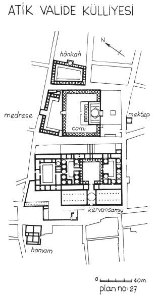
The great külliye of Atik Valide Camii was built by Sinan in 1583 for Nurbanu Sultan, wife of Selim II and mother of Murat III. This is the most splendid and extensive of all Sinan’s constructions in Istanbul with the sole exception of the Süleymaniye. In addition to the mosque itself, the külliye consists of a medrese, a hospital, an imaret, a tabhane a dar-ül hadis, a dar-ül kura, a mektep, a kervansaray, a hamam and a hânkah, or dervish hospice; all these buildings are still in existence, though some have not been restored and are not open to the public.
We enter the precinct by an alley beside the graveyard behind the mosque and find ourselves in one of the most beautiful of all the mosque courtyards, a grandly proportioned cloister with domed porticoes supported on marble columns; in the centre are the şadırvan and many ancient plane trees and cypresses. The mosque is entered through an elaborate double porch, the outer one with a penthouse roof, the inner domed and with handsome tiled inscriptions over the windows. Inside one finds a wide rectangular room with a central dome supported by a hexagonal arrangement of pillars and columns; to north and south are side aisles each with two domed bays; the aisles were added at a later date and although on a close examination the arrangement leads to certain anomalies, the general impression is very attractive. There are galleries round three sides of the room and the wooden ceilings under some of them preserve that rich painting typical of the period: floral and arabesque designs in black, red and gold. The mihrab is in a square projecting apse entirely revetted in magnificent tiles of the best Iznik period; note also the window-frames of deep red conglomerate marble with shutters richly inlaid with mother-of-pearl. The mihrab and mimber are fine works in carved marble.
The medrese of the complex stands at a lower level than the mosque and is entered by a staircase in the west wall of the courtyard. Its own courtyard is almost as pretty as that of the mosque itself and is oddly irregular, having five domed bays to the south but only three to the north. The dershane is in the centre of the west side in the axis of the mosque though at an obtuse angle to it, and it projects over the street below which passes under it through an archway. If one leaves the medrese by the gate in the south side, one can walk round the building and pass under this picturesque arch. At the next corner beyond it stands the large hânkah, or dervish hospice, also highly irregular in plan but quite as attractive as the other buildings. These various irregularities are partly due to the alignment of pre-existing streets and the varying level of the terrain, but were perhaps courted by Sinan to give variety and liveliness to his design, for he could quite easily have avoided them if he had chosen.
The mektep is across the street to the south of the mosque. Across the street to the west of the mosque are the imaret, tabhane, dar-ül hadis, dar-ül kurra and kervansaray, none of which are open to the public. The hamam, which has been restored and is once again in use, is two blocks west of the medrese and on the same street. One hopes that all of the buildings of that Atik Valide külliye will be restored and opened to the public, for it is certainly one of the half-dozen most impressive monuments of Ottoman architecture not only in the city but anywhere in the country.
ÇİNİLİ CAMİİ
The street to the east of Atik Valide leads after a walk of about one kilometre to Çinili Camii, a small complex by another Valide Sultan, Kösem, mother of Murat IV and the mad Ibrahim, built at the beginning of the latter’s reign in 1640. The mosque, in a pretty garden filled with flowers and trees, is small and simple: a square room covered by a dome, but it has both on the façade and in the interior a revetment of tiles (hence its name, çinili = tiled) just after the best period, but still quite fine, chiefly pale blue and turquoise on a white ground. The mimber of white marble has its carving very prettily picked out in gold, red and green, and its conical roof is tiled. The porch of the mosque is a baroque addition, as is the minaret, of which the şerefe has a corbel of very pretty folded-back acanthus leaves, such as we have seen nowhere else. In the precinct is a very fine şadırvan with a huge witch’s cap for a roof, and a tiny medrese triangular in shape sloping headlong down hill. Just outside the precinct is a handsome mektep, and not far off a large hamam also belongs to the foundation.
The street outside the mosque, Çavuş Dere Caddesi, winds downhill and in about a mile leads one back to Iskele Meydanı.
There are many interesting and pleasant excursions to be made in the environs of Üsküdar, for, as Evliya Çelebi informs us: “Üsküdar is surrounded on all sides with delightful walks.” These places can easily be reached by bus or taxi from the Iskele Meydanı, or, if one is feeling really energetic, one could stroll to them through the town none of them is at any great distance.
CEMETERY OF KARACA AHMET
One walk for which Üsküdar is famous is that to the vast Turkish cemetery of Karaca Ahmet which covers the hills to the southwest towards Kadıköy. This rivals in extent and picturesqueness the cemeteries outside the walls of Stamboul and in Eyüp. Acre after acre is thick with cypress trees and with serried but topsy-turvy ranks of tombstones; here and there an old suterazi or water-control tower rivals the trees in height and gauntness. Many of the older tombstones are beautifully designed and carved, usually bearing elaborate obituary inscriptions, some of which are quite poetic and touching and others even irreverent and amusing. The stones are topped with representations of the headdresses of the deceased, from which we learn their sex and station. The tombstones of the men are surmounted with large stone turbans, whose variety exhibit the full range of the Ottoman civil, military and religious hierarchies; here and there we see the turban of a paşa, a dervish, a sipahi or a eunuch. Those of the women are decorated with floral designs in low relief and are crowned with archaic oriental hats or draped with simple shawls, feminine even though in stone. One could stroll for hours in this serene suburb of the dead.
BARRACKS AND MOSQUE OF SELİM III
At no great distance from the cemetery are the gargantuan barracks of Selim III. The barracks, a huge rectangle with very characteristic towers at the corners, are now chiefly famous as the scene of Florence Nightingale’s ministrations during the Crimean War. They were originally erected in wood by Selim III to house the new troops he hoped would quell and take the place of the Janissaries. Later they were partly rebuilt in stone by Mahmut II after he had in fact liquidated that rebellious corps; and later still the rest was done in stone by Abdül Mecit. They are still used by the military; the general public can visit the little museum in the tower where Florence Nightingale lived when she was running the hospital.
Opposite the main entrance to the barracks is the mosque that Selim III built for his new corps of soldiers. Built in A.H. 1209 (A.D. 1803–4), it is the last and one of the handsomest of the pure baroque mosques. Not only are its proportions and details most attractive, but it is placed in an exceptionally lovely garden with three of the finest plane trees in the city. The interior as usual is a little stark, though of impressive proportions. The western gallery, the mihrab and the mimber are all of highly polished (too highly polished) grey marble and give the place a certain charm. A short distance to the south of the Selimiye barracks we find the British Crimean cemetery.
ÇAMLICA
In describing the excursions in the neighbourhood of Üsküdar, Evliya tells us that “the most celebrated walk of all is that of Great Camlıca, where a kiosk was built by the present monarch (Mehmet IV), the chronograph of which was composed by me, poor Evliya.” The Great Çamlıca stands about four kilometres east of Iskele Meydanı and can be reached by the main highway leaving Üsküdar in that direction. It is the taller of the twin peaks of Mount Bulgurlu, the highest point in the vicinity of Istanbul (267 metres above sea level). There is no trace of the imperial kiosk mentioned by poor Evliya, its place being taken by a large teahouse and café in the midst of the pine grove which gives the peak its name (cam = pine). From here there is an absolutely magnificent view, which makes it well worth the climb. In the morning when the sun is still easterly one has a clear panoramic view of the whole city: the Bosphorus almost as far as the Black Sea, the Marmara with the Princes’ Islands, and behind that the great snow-covered peak of Ulu Dağ, the Bithynian Olympos. Towards evening the sun sets almost directly behind Stamboul and its domes and minarets are silhouetted against the flaming western sky.
KIZ KULESİ
One of the most familiar sights in Istanbul is perhaps the one least visited. This is Kız Kulesi, the Maidens Tower, which stands on a tiny islet a few hundred metres off Üsküdar. Its Turkish name is derived from the legend concerning a princess who was confined there by her father to protect her from the fate foretold by a dire prophecy: that she would die from the bite of a serpent. Needless to say, the princess was eventually bitten by the serpent, smuggled out to the islet in a basket of grapes. In English the place is usually called Leander’s Tower, in the mistaken notion that Leander drowned there in his attempt to swim the strait to see his lover Hero, which legendary tragedy actually occurred near Abydos in the Dardanelles. According to Nicetas Choniates, the Emperor Manuel I Comnenus in the twelfth century built a small fortress here to which he attached one end of the chain with which he closed the strait, the other end being attached to the Tower of Mangana below the acropolis. Since then it has been used as a lighthouse, semaphore station, quarantine, customs control point and home for retired naval officers. The present building dates from the eighteenth century. It has recently been rebuilt and now houses a restaurant and café.
THE PRINCES’ ISLANDS
The most famous of all the beauty spots in the vicinity of Istanbul are the Princes’ Islands, the little suburban archipelago just off the Asian coast of the Marmara. The isles are about an hour’s sail by ferry from the Galata Bridge, though in spirit they seem at a far greater remove than that, so different are they from the rest of the city in atmosphere and appearance.
During Byzantine times the islands were inhabited only by fishermen and by the monks and nuns in the monasteries and convents that had been founded there, most of which at one time or another housed emperors, empresses and patriarchs who had been exiled to the islands. It is only since the latter half of the nineteenth century that the Princes’ Islands have become fashionable as resorts and places to bathe and picnic. Before that they were sparsely inhabited and rarely visited. But their picturesqueness and their rather grim historical associations appealed to the romantic imagination of the nineteenth century. This aspect of the islands is well preserved in a purple passage at the beginning of Gustave Schlumberger’s charming book Les Isles des Princes:
Naples has its Capri and its Ischia; Constantinople has its Princes’ Islands. The Neapolitan is not more proud of the jewels which adorn his bay than is the Greek of Pera of his charming islands, places of repose and pleasure, that raise their enchanting silhouettes at the entrance to the Sea of Marmara. Just as the crimes of Tiberius almost as much as the splendours of nature have made Capri famous, so the gloomy adventures of emperors, empresses, and all the exiles of high rank, relegated to the convents of Proti, Antigone, and Prinkipo as a result of the revolutions with which the history of Byzantium bristles, have made these radiant islands one of the most tragic sites of the ancient world… Add to these moving souvenirs the fact that this archipelago in miniature possesses beauties designed to ravish an eye sated with the marvels of Italy and Sicily; that nowhere does the delighted eye repose on coasts more lovely, on a bay more gracious, on mountainous distances more grandiose; that nowhere is the verdure fresher or more varied; that nowhere in short do bluer waters bathe more gently a thousand shady coves, a thousand poetic cliffs; you will then understand why the Princes’ Islands, bedewed of yore with so many tears, vaunted today with so much praise, are a favourite place of pilgrimage for all those who are attracted by the study of a dramatic past or the charm of a smiling present.
Unfortunately, the souvenirs of the past so poetically evoked by Schlumberger must be supplied by the imagination – or by that scholar’s fascinating essay – for the islands preserve almost no relics of antiquity: the convent cells bedewed with tears have vanished without a trace or survive only in a crumbling wall, a half-buried cistern. The beauties of nature, however, remain, though they are fast being encroached upon by summer villas and camping sites, especially in Prinkipo; but the smaller islands and the more outlying parts of that one are still as lovely as Schlumberger describes them.
The little archipelago consists of nine islands, four of them of a certain size, the rest tiny. Ferries stop in turn at the four principal isles, the closest of which is Kınalı, known to the Greeks as Proti, followed by Burgaz (Antigoni), Heybeliada (Halki) and finally Büyükada (Prinkipo), the largest and most populous of the isles. During the summer months there is a ferry from Büyükada to Sedef. There are a few summer residents on Kaşıkadası (Pita), but Tavşanadası (Neandros), Yassıada (Plati) and Sivriada (Oxia) are uninhabited. Except for a few municipal vehicles, only faytons, or horse-drawn carriages, are used on Büyükada, Heybeliada and Burgaz, while not even those are allowed on Kınalı.
The nearest of the large islands is some 15 kilometres from the city; it is appropriately called Proti (First) by the Greeks. Its Turkish name is Kınalı, Dyed-with-Henna, because of the reddish colour of its cliffs along the shore. It is a rather barren island, but the village is very pretty and next to it there is a pebble beach. The house at #23 Fazıl Ahmet Aykaç Caddesi was the home of the famous Armenian composer Gomidas during the years 1909–13. The island has always had an Armenian community, though here and on the other three large islands the great majority of the year-round residents are Muslim Turks, with small Greek communities on Burgaz, Heybeliada and Büyükada, where there is also a Jewish community. In times past the islands were predominately Greek. The Armenian church, dedicared to St. Gregory the Illuminator, was founded in 1857; the present building is the result of a complete reconstruction in 1998. The Greek church, dedicated to the Birth of the All Holy Mother of God, was founded in 1886. When the foundations of the present church were being built a number of ancient architectural fragments were unearthed, and two of these are now arrayed in the forecourt, including a sixth-century capital similar to those in Haghia Sophia. It is possible that these belonged to a Byzantine monastery that stood on this site.
There is a Greek monastery dedicated to the Transfiguration of Christ on the peak of one of the island’s three hills, Manastir Tepesi. This was built in the Ottoman period on the site of a Byzantine monastery of the same name. Three Byzantine emperors spent their last days in exile in this monastery after they were deposed: Michael I Rhangabe (r. 811–13), Romanus I Lecapenus (r. 919–44) and Romanus IV Diogenes (r. 1067–71).
The second large island is called Burgaz by the Turks (from the Greek pyrgos = tower), on account of an ancient watchtower on its summit that is mentioned by travellers as late as the beginning of the eighteenth century. The Byzantines called it Panormos or later – and still today – Antigone. It is about the same size as Kınalı but much more fertile and well-wooded, and thus more pleasant to wander about on.
The village is quite pretty and there are a number of fine houses of the late Ottoman and early Republican eras. The house at #15 Çayır Aralığı Sokağı was in the years 1934–54 the house of the famous writer Sait Faik Abasıyanık, and it is now open as a museum dedicated to his memory.
The most prominent monument in the village is the Greek church of St. John the Baptist, built in 1899. The church is believed to stand on the site of a Byzantine monastery of the same name. This was the monastery where St. Methodius Confessor, Patriarch of Constantinople (r. 842–6), was exiled by Michael II in the years 822–9 because of his opposition to the emperor’s policy of iconoclasm. The crypt beneath the present church of St. John is dedicated to St. Methodius, for this is where he is believed to have been imprisoned during his exile on the island.
The Greek monastery of St. George Karyptis is on the northern shore of the island, approached along Gönüllü Caddesi. Although the monastery is believed to have been founded in the Byzantine era, the earliest reference to it is in the second half of the seventeeenth century. This was when the Greek innkeepers of Istanbul decided to restore and maintain the monastery, which apparently had fallen into ruins. The present dormitory was erected in 1858–9, while the church was erected in 1897. There are ancient architectural fragments which would appear to have been part of the original monastery, including a capital in the courtyard and part of an architrave set into the entryway of the enclosure.
The site of the Byzantine monastery of the Transfiguration of Christ is on the summit of Hristos Tepesi, the Hill of Christ. Greek tradition has it that the monastery was founded by Basil I the Macedonian (r. 867–76), and there is evidence of a decree by Manuel I Comnenus granting its rights as a monastery in 1158. The earliest reference to the monastery after the Conquest is by Petrus Gyllius in 1547. All that remains today is an abandoned church built in 1869 and a two-storey building erected in the eighteenth century, along with the ruins of earlier structures. Inside the entrance to the enclosure there are a number of ancient architectural fragments, including four beautifully carved Byzantine capitals.
Just opposite the landing-stage at Burgaz is a tiny island called Kaşık, or Spoon, because of its shape. Its Greek name is Pita, or Piece of Bread. It is the smallest isle of the Princes’ Islands and its highest point is a mere 18 metres above sea level. It has no known history, and it was the only isle in the archipelago that did not have a monastery in Byzantine times. It was virtually uninhabited up until recent times, but now a number of summer houses have been built on it.
Some little distance off to the west of Burgaz lie the two small outlying islands of the group, Sivriada, known in Greek as Oxya, and Yassıada, Plate in Greek. The Turkish and Greek names are descriptive and mean the same thing in each case – the Pointed and the Flat. Both islands are uninhabited; they can be reached by hiring a boat on Burgaz.
Sivri is nothing but a tall craggy reef rising to a height of 90 metres, taller than any of the Seven Hills of Constantinople. The south-eastern part of the island was used as a quarry to provide stone for the new Kadıköy pier and breakwater, and as a result that side of the hill has been gouged away. Beside the landing-stage you can see the substantial remains of a Byzantine monastery. This is mentioned in the list of monasteries compiled in 1158 by Manuel I Comnenus. The monastery had two churches: a katholikon of the Archangel Michael and a chapel dedicated to a number of martyr saints. The island’s chief fame in more recent times stems from the fact that on several occasions all the wild dogs of Istanbul were rounded up and exiled there where they soon ate each other up.
Yassıada, as its name implies, is relatively flat, with a maximum elevation of 40 metres. It too had a monastery, founded, according to tradition, in the mid-ninth century by St. Ignatius, twice Patriarch of Constantinople. The monastery is mentioned in the list compiled in 1158 by Manuel I Comnenus, who noted that it had a katholikon dedicated to the Forty Martyrs and also a chapel of the Virgin. Ernest Mamboury, in his 1943 guide to the Princes’ Islands, reports that he found remnants of one of these churches, whose ruins now seem to have vanished. Directly above the landing stage we see the folly that Murray’s Handbook of 1892 quaintly describes as “a dilapidated Anglo-Saxon castle”, built by Sir Henry Bulwer, English ambassador to the Sublime Porte and brother of the novelist Bulwer-Lytton; here he is popularly supposed to have indulged in nameless orgies. To the right of this we see one of the buildings erected for the trial of the deposed Turkish Prime Minister Adnan Menderes and several of his associates. After a lengthy trial they were convicted, whereupon on the night of 16–17 September 1961 Menderes and two of his ministers were hanged on Imralı, an island off to the south-west in the Sea of Marmara. Other abandoned buildings on Yassıada were structures erected in the 1960s for a short-lived military school.
The third of the large islands is nowadays called Heybeliada, Saddle-Bag Island, from its shape; anciently it was known as Chalkitis or Halki, from the famous copper mines mentioned by Aristotle. The island has (or had) two important schools of rather different sorts. The elder, which was closed by the government in 1971, was the principal theological seminary of the Greek Orthodox Church, housed in modern buildings among the remnants of the Monastery of the Holy Trinity, of Byzantine foundation, on an incomparable site in the saddle between the two summits of the northern hill. The younger, the Turkish Naval College, is chiefly at the water’s edge near the landing stage, but also occupies the site of another Byzantine monastery on a hill to the west. This site preserves the only surviving Byzantine church in the Islands, and a very interesting one. Dedicated to the Blessed Virgin Kamariotissa, it is a tiny chapel of the quatrefoil or tetraconch variety, that is, with a central dome surrounded by four semidomes over exedrae, three of which project on the outside, the fourth being contained within the narthex. The other church of this plan in the city, that of St. Mary of the Mongols, has been completely wrecked by subsequent rebuilding, so that the present little chapel is the only example of its kind that more or less preserves its original plan. The chapel is attributed to Maria Comnena, third wife of John VIII Palaeologus and the last Empress of Byzantium. It was built some time between 1427 and 1439 and is thus the last known church to be erected in the city before the Turkish Conquest. The church remained in the possession of the Greek community up until 1942, when it was confiscated by the government. It is not generally open to the public, but permission to visit it may be obtained from the Com mandant of the Naval School.
On the shore south of the village, just beyond the grounds of the Naval School, we see the monastery of Haghios Georgios tou Kremnou (St. George on the Cliff). The setting is quite beautiful, with pines, cypresses and other trees embowering the picturesque buildings of the monastery above the blue Marmara. The monastery is believed to have been founded in the years 1586–93; it is still functioning, though with only one or two monks in residence.
There is another monastery on the south-west coast of the island, that of St. Spyridon. This little monastery was founded in 1868 and restored in 1968 by the then Patriarch, Athenagoras. The katholikon of the monastery remains in use, though services are held there only occasionally. There are the remnants of still another monastery, that of the Metamorphosis of Christ the Saviour, on the peak known as Baltacıoğlu Tepesi at the south-eastern end of the island. This was founded in 1835; all that remains today is a small chapel and an attached house, both embowered in a picturesque setting on the hilltop.
The Greek church of St. Nicholas dominates the main square in the village. It was erected in 1857 on the ruins of a Byzantine church dedicated to St. Nicholas, the patron of mariners, appropriate for an island where in times past virtually all of the men were seafarers or fishermen.
The house at #7 Refah Şehitler Caddesi is now a museum dedicated to the memory of Ismet Inönü, the first prime minister of the Turkish Republic and later president of Turkey. The house at #19 Demirtaş Sokağı is a house museum honouring Hüseyin Rahmi Gürpınar, the renowned journalist, essayist and novelist.
We come at last to the largest of the islands, Büyükada, the Greek Prinkipo. This is the only one most people visit and is the summer resort par excellence. Its rapidly expanding village has a large number of attractive residences surrounded by well-kept gardens, several good hotels and a very posh country-club, the Anadolu Club. Some of the grandest of the mansions are along Çankaya Caddesi, including the Fabiato Köşkü, built in 1878 and restored in 1997 by Çelik Gülersoy of the Turkish Touring and Automobile as the Büyükada Cultural Centre, with a café-restaurant. The Iliasko Yalı Köşkü at the foot of Hamlacı Sokağı was during the years 1929–33 the home of Leon Trotsky when he was living in exile on Büyükada, and it was here that he wrote his autobiography and began his History of the Russian Revolution.
There are two Greek churches in the village. The church of the Dormition of the Mother of God was first erected on its present site in 1735 and was renovated in 1871. The church of St. Dimitrios was built in 1856–60. When the foundations were being laid workers found a relief monogram of the emperor Justin II (r. 565–78), who built a palace and monastery on the island in 569. It is from Justin that the island took its name Prinkipo, the Isle of the Prince.
Once you get out of the built-up area you find lovely pine groves and other forests, wild cliffs plunging down to the sea, and sandy coves for bathing. But in summer the island is really too crowded; the best time for a visit is early spring or late autumn, or on those magical warm and sunny days that occur here from time to time in the depth of winter: then the island is really perfect, for you have the amenities of civilization without the people.
The island consists of two large hills separated in the middle by a broad valley, so that the road around it makes a figure eight. You can make the tour by fayton, the Büyük, or Grand Tour, going all the way round the island and the Küçük, or Short Tour, going around the northern half. From the road that crosses the island between the hills, foot paths lead up on either side to the monasteries which crown each. The Monastery of the Transfiguration on the north hill, Isa Tepesi, or the Hill of Christ, is in the depths of a pine forest. The original monastery is mentioned in the list compiled in 1159 by Manuel I Comnenus, and the first mention of it after the Conquest is in 1597; the katholikon of the present monastery is due to a complete rebuilding in 1869.
On the southern hill, Yiice Tepe, is the more famous monastery of St. George Koudonas; situated at almost the highest point of the island, 202 metres above the sea. According to tradition, the monastery was founded during the reign of Nicephorus II Phocas (r. 963–9), and it is mentioned in the list compiled in 1158 by Manuel I Comnenus. The present complex includes, besides the monastery itself, six separate churches and chapels on different levels, the older ones being on the lowest levels. The monastery celebrates the feast-day of St. George on 23 April, when many thousands of pilgrims make their way to the hilltop, some of them walking barefoot, tying talismans to the branches of the bushes and trees along the way. Many of them have lunch at the little outdoor restaurant beside the monastery drinking the rough red wine made by the monks, in a setting reminiscent of the Aegean isles.
The great block of monastic buildings on the western side has a pretty courtyard with galleries along one side; at the back it plunges dramatically into the valley below and looks from there like a fortress. From here one can look out across the sea to the remaining islands of the group. To the west is tiny Sedef Adası, the Island of the Pearl, known in Byzantium as Antherovitos. To the south we see the uninhabited little crag called Tavşan Adası, Rabbit Island, known anciently as Neandros. Both of these islets once had their monasteries, of which now only a few scattered stones remain. A number of summer villas have in recent years been built on Sedef, but Neandros is inhabited only by sea-birds, who can be seen in their thouands perched on the cliffs on the southern end of the island.