11
Venus, Earth and Mars all started from about the same circumstances, looking as alike as baby triplets, but history led to the development of three individual planets, ours (we think) the most exceptional. Cosmic history made a world of difference to the Earth. How did this happen?
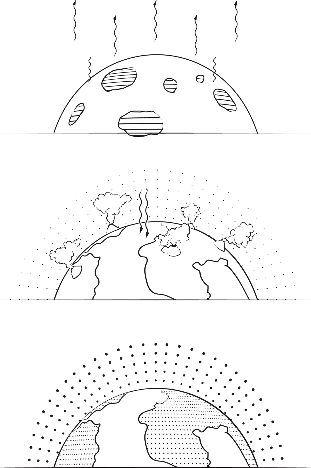
Earth’s first atmosphere was drawn in from the solar nebula, and was replaced by a second, from volcanoes. The present atmosphere is the third, its composition generated by life in the oceans.
The Hadean Eon: the new-born Earth
If we were astronomers living on a planet orbiting another star, say, 100 light years away, and if we could identify exoplanetary systems, we might discover the solar system in orbit around our Sun. If, further, we could characterize the planets of the solar system to the same extent that we can characterize exoplanets at the present time, we would think that Earth, Mars and Venus are fundamentally not very different. Each is a rocky planet of much the same size, in adjacent orbits in the solar system. Yet from the much more favourable vantage point from which we can study these planets, we know how different they are. Venus has a thick atmosphere primarily of carbon dioxide over a hot, volcanic, sterile land surface, covered by sulphurous clouds. Mars, on the other hand, is a cold, almost completely dry, sandy, almost sterile desert with a thin atmosphere, also of carbon dioxide. And as we know, because we live here, Earth has a variety of solid terrains and water bodies, an atmosphere of nitrogen and oxygen and a variety of equable climates that support different forms of life everywhere, sometimes in abundance. The three planets look quite different.
How typical among planetary systems in general are the three terrestrial planets in our solar system? More than three thousand stars are known to have a planetary system. It is a challenge to learn anything about the individual planets in an exoplanetary system, but for a number of planets it is possible to estimate two of their properties: their mass (because the planet pulls its sun) and their diameter (because they block out some of their sun’s light as they transit periodically across its disc). Such planets fall into two main groups: planets that are large and gaseous (like our Jupiter) and planets that are small and dense (like Earth). Deducing the structure of such Earth-like planets is certainly not as easy as adding two and two to make four; it is like adding one and one in the expectation that we might later find some further numerals to add to make four.
The currently available evidence offers up the following highly simplified picture of a typical, new-born, Earth-like planet such as our own Earth, Mars and Venus. Its dense inner part consists of an iron core, containing perhaps one-third of its mass. The core is surrounded by a rocky layer, the bulk of the solid planet, perhaps as much as two-thirds of the mass. There might be an outer layer of water that might be as much as the same mass again as the inner part. And it is all surrounded by a light gaseous atmosphere of hydrogen and helium.
During its infancy, in its first millions of years of life, the Earth developed this typical structure, modified further by impacts of asteroids (one large one in particular, when the Earth was aged 100 million years or so, which made the Moon). From this start, the Earth set off on its path to become the planet on which we live. This early period has left subtle traces in geology as the first eon of Earth’s history.
In geology, the Earth’s history is divided into four eons, each very roughly a billion years in length. The first, the period after which the Earth developed into its maturity, is called the Hadean Eon, named after the hellish environment of lava, volcanic eruptions and bombardments. Whether the name is apposite is questionable: Hades was the Hell of classical Greece, whose people imagined it as a dark, cold and gloomy place, not like the early Earth at all. What must have been in mind when the term was coined in relation to geology is the Hell of Christianity and Islam, which, threatened as a torment for wicked people who lived in places that are sometimes debilitatingly hot, is said to be even hotter and filled with blazing fire and sulphurous fumes.
How did the Hadean Eon come to be like this? As outlined in Chapters 9 and 10, the Earth originated 4.54 billion years ago from the solar nebula by the accretion of, at first, gas and dust and, later, by large, solid pieces. Heat from the frequent, repeated impacts of the pieces melted the impact sites. The heat was slow to leak away, and further heat was liberated inside the Earth by the decay of radioactive elements. The temperature built up and the surface of the Earth became molten magma at a temperature of thousands of degrees.
The surface of the Earth thickened with further accreted material. The outer layers acted as a blanket and trapped heat inside the surface. The interior of the Earth remained molten for millions of years. The element iron is very dense and, liquidized, it sank downwards. It took with it siderophile (‘iron-loving’) elements – chemical elements that at high temperatures readily dissolve in iron – including cobalt, nickel, ruthenium, rhodium, palladium, tungsten, rhenium, osmium, iridium, platinum and gold. The siderophile-iron alloys melted and percolated towards the Earth’s centre.
By contrast, the lighter lithophile (‘stone-loving’) elements have a strong affinity for oxygen and readily formed lighter minerals that floated up towards the Earth’s surface. They include: lithium, beryllium, boron, oxygen, fluorine, sodium, magnesium, aluminium, silicon, phosphorus, chlorine, potassium, calcium, scandium, titanium, vanadium, chromium, bromine, rubidium, strontium, ytterbium, zirconium, niobium, iodine, caesium, barium, lanthanum, hafnium and the rare earths (the lanthanides).
This process, in which one group of elements sank into the Earth and another group floated up to the surface, resulted in the differentiation of the Earth into a layer of a rocky mantle over a dense, mostly liquid, mostly iron core. The process is called ‘the iron catastrophe’, although it does not seem to be as sudden and violent as a typical catastrophe, more a slow and persistent transport of the two groups of elements in different directions. It took 10 million years to get to the stage that we see now.
The fact that the Earth has a dense core was uncovered in 1774 by the then British Astronomer Royal, Nevil Maskelyne (1732–1811), who was following up an idea for an experiment put forward by Isaac Newton. Newton imagined a pendulum, normally hanging straight downwards in the Earth’s gravitational field, being positioned beside a mountain. The mountain would pull the pendulum off the vertical. The change of angle, as determined against the stars, could be measured, and that would give the pull of the mountain sideways to compare with the pull of the Earth downwards. Maskelyne chose Scottish mountain Schiehallion for his experiment because it is isolated from other mountains (which could disturb the measurements), it has steep sides so the pendulum could be close to the mountain’s centre of gravity and be pulled strongly, and it is a geometrical shape whose volume, and therefore mass, could be estimated readily.
Maskelyne and his team had to observe stars to establish the vertical and to survey the mountain to determine its volume. He had to fight the weather, since cloud hung about the mountain (according to Maskelyne, its Scottish name refers to ‘constant storms’). The cloud interfered with looking both up and horizontally, so his expedition took six months to complete its programme. The measurements gave the mass of the Earth, from which its average density could be derived. Modern figures give the average density of the Earth to be 5.5 grams per cubic centimetre (3.2 ounces per cubic inch) compared to the density of rock on the surface of our planet of about 3.0 grams per cubic centimetre (1.7 ounces per cubic inch). There must, therefore, be a high-density core inside the Earth in order to obtain the correct average.
In 1936, the structure of the Earth’s core was uncovered by the Danish geophysicist Inge Lehmann (1888–1993) who was studying seismic waves travelling through the Earth. Some seismic waves pass from the earthquake’s epicentre through the planet to seismometers located elsewhere on the surface. Their characteristics, such as speed and arrival pattern, reveal the structure of the regions through which they have travelled. Nowadays the data would be recorded digitally and analysed by computer, but Lehmann worked with written cards and pencils. She found that, underneath the rocky mantle, the Earth’s core is divided into two. An inner core of iron, nickel and other siderophiles is solid, with a diameter of 2,440 kilometres (1,500 miles), a temperature of about 6,000 degrees Celsius (11,000 degrees Fahrenheit) and a density of 13 grams per cubic centimetre (7.5 ounces per cubic inch). It is surrounded by a shell of iron and nickel, a liquid outer core, with an outer diameter of 6,800 kilometres (4,200 miles) and a density of about 10 grams per cubic centimetre (6 ounces per cubic inch); this is a couple of thousand degrees cooler than the inner core.
The rocky mantle that surrounds the core is made, most abundantly, of the mineral bridgmanite, named after Percy Bridgman, a 1946 Nobel Prize-winning American physicist who studied the behaviour of substances at high pressure. Its chemical name is silicate perovskite, with a chemical formula of (Mg,Fe)SiO3. It exists at the high pressures deep in the planet’s interior, at depths of between 660 and 2,700 kilometres (400 and 1,700 miles). It has also been found in some meteorites, presumably originating in similar locations in other planets (or asteroids) that have been shattered by collisions, or even relating back to meteor impacts on Earth that have blasted terrestrial material into space, only for it to fall back again millions of years later.
As described in Chapter 10, soon after the formation of the mantle in the iron catastrophe, at about 4.4 billion years ago, the proto-Earth, Gaia, collided with another protoplanet, Theia, and created the Moon. This process was very energetic and melted the Earth again, at least its outer parts. Soon after that, 3.9 billion years ago, the Late Heavy Bombardment pounded the surface of the Earth and melted it for a third time.
The Moon’s orbit then was much closer to Earth than it is today and there were strong tidal forces between the two bodies. The Earth locked on to a bulge that had developed in the Moon so that it was somewhat pear-shaped. The Moon kept the same hemisphere facing the Earth and still does: that is why we always see the same pattern of grey shapes on the Moon’s surface that folklore calls the man in the Moon (see page 209). Dissipation of energy by the tidal forces, acting over billions of years, sucked energy from the Moon’s orbital motion and the rotation of the Earth. The glancing impact by Theia on Gaia caused the proto-Earth to rotate quickly, with a day of about five hours (see page 198). Over the history of the Earth, its rotation slowed down and the Moon has retreated.
The day is still lengthening. Broadcast time (for example, the time signal heard as the ‘pips’ on BBC radio) is derived from atomic clocks that keep an accurately consistent time, so it gradually diverges from astronomical time derived from the Earth’s rotation. This is the reason why, by international agreement, extra leap seconds are sometimes inserted into the usual time sequence of broadcast time, when needed, at the average rate of an extra second every two years. This process resets broadcast time better into synchronism with the rotation of the Earth.
Earth’s atmosphere and the creation of the seas
The first atmosphere of the Earth was made of the lightest elements brought in from the solar nebula, namely hydrogen and helium and other interstellar gases. These would have included, no doubt, also so-called noble or inert gases heavier than helium such as neon. Helium and neon are the second and fifth most abundant elements in the Universe, but they do not combine chemically with anything, so they never get anchored to solids or liquids. They are always gases that are very lightweight and readily escape into space – there is now no more primordial helium left in Earth’s atmosphere at all, and only slight traces of neon.
In any case, the solar wind, the Earth’s heat, volcanic outgassing and possibly a collision between the proto-Earth and a giant impactor (a Pluto-sized planetesimal or larger – possibly the one that created the Moon) transformed this first atmosphere through an abundance of heat and vigorous chemistry. The first atmosphere was replaced with the second, an atmosphere of hydrogen together with carbon and hydrogen compounds, like carbon dioxide and steam, emitted by volcanoes and also volcanic processes driven by the heat of the ocean of magma, which still covered the Earth at that time, or the collisional energy of the giant impactor. Smaller planetesimals, comets, meteorites and asteroids of all sizes impacted into the magma ocean, melting and vaporizing any icy minerals like hydrogen cyanide, which they brought in from the solar nebula, all contributing further to a rich gaseous mixture. Methane and ammonia were also constituents of the atmosphere, but these are unstable when exposed to ultraviolet light, so this atmosphere was thus smoggy, with particles generated from organic molecules produced by the action of the Sun’s ultraviolet light on the gases. In the solar system, the only other place with a similar atmosphere now is Saturn’s satellite Titan, although it is far from the Sun and much colder than the Earth’s atmosphere at that early time. There is no free oxygen in the atmosphere of Titan, nor was there in the atmosphere of the Earth then.
The composition of this early terrestrial atmosphere created a strong greenhouse effect, which compensated for the reduced luminosity and warmth of the Sun at that time: even though the Earth’s temperature dropped as the heat of its formation radiated away, its second atmosphere prevented the surface of the Earth from freezing.
This all occurred in the first eon in Earth’s history, the Hadean, and lasted from the birth of the Earth 4.5 billion years ago until approximately 4 billion years ago. The violent events that occurred during this eon scrambled the surface rocks of the Earth, burying most, so that its first half-billion years of geological history are very difficult to decipher, and presumably always will be. No, or very few, fossils are known from this time. Although absence of evidence is not definitive evidence of absence, and I have described reasons why the evidence might have been destroyed, concealed or muddled, the inference is that life had probably not yet emerged on Earth, although in the future exceptions might be discovered.
In the last years of the Hadean Eon, the Earth recovered from the impact that created the Moon and from the Late Heavy Bombardment, and prepared for the evolution of life. The surface of the Earth solidified. Water vapour was liberated from the planet’s interior, produced by outgassing from rocky materials caused by strong volcanic and meteoric activity. The temperature cooled enough to condense the water, creating warm lakes, seas and oceans. Ice from comets that fell on Earth from the rest of the solar system melted and brought further water, topping up the oceans. Oceans covered a substantial fraction – perhaps all – of the Earth’s surface, as now; by some sort of coincidence the volume of water on Earth is about the same as the total volume of the depressions in the Earth’s crust. However, the highest mountainous areas rose above the ocean’s surface. By contrast, Jupiter’s satellite Europa is covered everywhere with an iced-over ocean to an average depth of several kilometres, a colder vision of Earth at the end of the Hadean Eon.
The weather in the Hadean Eon would have included rain as well as thick clouds, and strong winds were driven by large temperature differences. The eroding effects of the atmosphere on rock formations through the effects of rain and wind had begun in the Hadean almost from the birth of the crust of the Earth. Small grains of rocks that had broken away from the main surface features were blown by the wind to accumulate into more sheltered places and were flushed by streams into lakes and seas to build up new rock strata. Volcanic eruptions pumped ash and pulverized rock into the atmosphere to cause new deposits in drifts. Lava flows from vents filled depressions to overflowing. These processes continue even now, erasing the older features of the landscape and covering them up, ceaselessly rewriting the geological record of the Earth’s history.
For the planet Venus, a similar resurfacing was very dramatic. NASA’s Magellan spacecraft imaged Venus during a four-year mission (1990–94) to map its surface using radar. It found that Venus is currently entirely covered with a volcanic landscape. Lava has flowed from numerous volcanic craters but the lava plains are punctured by very few meteor craters. Calibrating the surface density of meteor craters on Venus against other worlds like the Moon to estimate how much time must have passed to produce that many, planetologists estimate that the entire planet was resurfaced between 1 billion and 500 million years ago. Volcanic activity on Venus in that period was stupendous but the cause of the outbreak is unknown.
Although the Earth was probably virtually lifeless in the Hadean Eon, life may have been possible in or near hydrothermal vents under the seas, deriving energy not from sunlight but from water heated by volcanic activity. Jupiter’s moon Europa might be similar. Like its neighbour Io, which has many active volcanoes, Europa (pl. XIV) is still being heated by tidal forces from Jupiter. As Europa moves in its eccentric orbit closer to and further from its parent planet, it moves between a strong and a weak gravitational force. Its material structure is ‘worked’ – that is, it is alternatively stretched and compressed. The interior of the satellite gets hot, not so much as Io, but to a certain extent. Heat builds up and melts Europa’s surface ice from below: underwater volcanic activity is probably another result. Life on Earth may have first emerged in a deep ocean trench with an environment like this. It looks as if Europa would be worth exploring as a potential home for extraterrestrial life, but the hard part about finding life on Europa will be the journey through a kilometre of ice in order to dip into its ocean, then to get out with samples, having dived some further kilometres to the ocean floor. However that works out in the future and illuminates the origin of life elsewhere, the end of the Hadean and the beginning of the following calmer eon, known as the Archaean, seem to have been when life got under way in the seas here on Earth.
Earth’s magnetic field and the magnetosphere: our shield against the capricious Sun
For centuries, European and Chinese sailors knew that lodestones (pieces of the mineral magnetite that constitute a magnetic compass) indicated the general direction of the north. If freely suspended – for example, floating on cork on the surface of water – a lodestone makes it possible to navigate a ship if the shore or the stars are not visible. The magnetic properties of the lodestone can be transferred to an iron needle for greater clarity of direction.
In 1576, an English ship’s instrument maker, Robert Norman, noticed that a magnetized needle not only turned to point north, but also tended to dip down below the horizontal. The angle of dip was about 70 degrees in London. In 1600, the English physicist William Gilbert realized that this was because the needle was following lines of magnetic force that slope down into the Earth, and which extend up and out into space.
Between 1698 and 1700 the English astronomer Edmond Halley (1656–1742) combined his own magnetic survey of the Atlantic Ocean with other people’s measurements to produce the first map of the world showing the direction in which a magnet pointed at any given location. His map showed that the magnetic field of the Earth is approximately a dipole, similar to that of a bar magnet, with its magnetic poles near to the geographic poles. A better approximation is possible by tilting the bar magnet by about 10 degrees from Earth’s rotation axis. The simple, theoretical dipole magnetic field centred on the Earth’s centre and most closely approximating the actual magnetic field has north and south poles that lie at places on the Earth’s surface called the geomagnetic poles. The North Geomagnetic Pole is in Ellesmere Island, in northern Canada near Greenland. The South Geomagnetic Pole is in Antarctica, not far from the Russian Vostok Research Station.
The actual magnetic field of the Earth is more complicated than a simple dipole and it is not centred exactly on the Earth’s centre. At what are defined as the magnetic poles, the actual, not the theoretical, magnetic field points directly into or out of the surface – the dip angle is 90 degrees. The North Magnetic Pole is in the Arctic region, the South Magnetic Pole in Antarctica.
The magnetic field is generated and sustained in the liquid outer core of the Earth by a dynamo process fed by motions of the liquid. The motions are driven by heat escaping from the inner core below, which causes convection of the molten iron, and by rotation, which drags the molten iron into a spin. There is also a swirling effect that is due to the scraping of the liquid outer core dragged against the solid inner core. The strength of the field at the surface of the Earth varies from region to region by a factor of two, with an average of 0.5 Gauss. There is a particularly large weak spot called the South Atlantic Anomaly, stretching from northern Chile to Africa’s southern Cape. There must be corresponding variations in the temperature and density of other physical features in the flow of molten iron under the Earth’s surface, for example a bump on the underside of the mantle.
The long-term history of the Earth’s magnetic field is written in old rocks. They preserve residual traces of the Earth’s magnetic field at the time that they solidified, provided they have been minimally altered since then. Rock specimens of different ages found at the same location are magnetized in different directions. They show that the direction of the axis of the Earth’s magnetic dipole does not stay the same all the time, as English astronomer Henry Gellibrand discovered in 1635. This means that, although the geomagnetic poles do not move much, the geographic locations of the magnetic poles have considerably varied over the centuries, moving erratically by about 15 kilometres (9 miles) per year on average.
For some reason, the North Magnetic Pole has been moving much more quickly than average since 1990, at about 50 kilometres (30 miles) per year. It has moved northwards from Hudson’s Bay in Canada and now lies in the Arctic Ocean. In 2017, it crossed the International Date Line close to the geographic North Pole and has now tracked from the sea north of Alaska into the sea north of Siberia. Likewise, the South Magnetic Pole has moved off the continent of Antarctica and is in the Ross Sea, just offshore in the direction towards Australia.
The magnetic field of the Earth extends to thousands of kilometres above the Earth. It is a structure called the magnetosphere, which acts like a bottle, surrounding us and shielding us against high-energy charged particles in the solar wind. The Earth’s magnetosphere deflects most of these solar particles. If this was not the case, the cumulative effect of radiation might have prevented life on Earth. Even so, the Earth is frequently hit by energetic solar flares, particles from which leak into the magnetosphere causing geomagnetic storms, the aurorae and other electrical and magnetic effects (see Chapter 7).
As discovered by US geophysicist James Van Allen (1914–2006) in 1958 from the first American space probes, Explorer 1 and Explorer 3, charged particles within the magnetosphere form a doughnut-shaped region that encircles the Earth. A second, outer ring was identified later in 1958. These regions of radiation were named the Van Allen Belt in honour of their discoverer and were the first major scientific discovery to be made as a result of space exploration. Because human beings and delicate electronic equipment are susceptible to dense radiation, the Van Allen Belts, and similar regions, are factors influencing the planned trajectories of spacecraft, particularly manned spacecraft, which have to traverse them to get out to the Moon and beyond.
The early magnetic field shielded the Earth’s atmosphere, preventing both air and surface water from being removed from the planet, even at a time when the solar wind was more intense. It is thought that the Earth’s magnetic field is currently generated in the interaction between the inner solid core of the Earth and its liquid outer core. The inner core appeared about 565 million years ago.
The present configuration of the magnetic field of the Earth is thus a phenomenon of our planet’s maturity. It has not, however, settled into inactive old age. Not only does the magnetic field move in its orientation, with the poles tracking underneath the Earth’s surface as described above, but also from time to time, it undergoes a more drastic change: it changes polarity (the North Magnetic Pole changes to the position of the South Magnetic Pole and vice versa). It changes by somersaulting quickly, turning upside down.
The timing of the changes does not show a clear pattern. It seems that there are geomagnetic epochs of about half a million years during which the polarity is predominantly as now, and which alternate with epochs with the reverse polarity, switching back and forth. But there are also briefer periods of perhaps tens of thousands of years when the polarity makes a brief excursion from the predominant direction at that epoch to the reverse, and back again relatively quickly. Nearly two hundred magnetic field reversals have been identified as occurring during the past 80 million years, some more firmly established than others.
The most recent switch of major geomagnetic epochs was about 770,000 years ago (the Brunhes–Matuyama reversal, named after French and Japanese geophysicists of the early twentieth century). The best established, most recent, minor excursion took place 42,000 years ago and lasted 800 years. It is known as the Laschamp event, after the French location in the Massif Central where rocks were found with the magnetic traces that revealed its existence.
The history of the reversals shows as stripes of alternate magnetic polarity running parallel to the Mid-Atlantic Ridge in rocks of the Atlantic seabed, laid down as the ocean floor spreads out from the ridge towards both the east and west shores of the ocean. The rocks ‘remember’ the terrestrial magnetic field at the time they solidified and then get pushed outwards away from the ridge by subsequent lava emissions.
The time that it takes to complete a reversal is controversial, with some estimates given at several thousands of years, while others suggest just a few human lifetimes – perhaps it varies from reversal to reversal. For some period of time during the reversal, the Earth’s magnetic field is much weaker, perhaps just a few per cent of its normal value. At that time, the atmosphere and the surface of the Earth are more exposed to the solar wind of cosmic rays and to high-energy radiation associated with increased auroral activity; it is not known what happens temporarily to the natural environment at that time, but whatever happens it must be survivable because reversals have happened often in the past and life persists here.
The usual time between major reversals is about 500,000 years, but the last major occurrence was nearly 800,000 years ago, so the next reversal is somewhat overdue. Are we then all doomed? No, but there may well be selective consequences. An Australian study in 2021 pointed out that the Laschamp event happened at the same time that Neanderthals and Australian marsupial megafauna became extinct. People of the species Homo sapiens took to living in caves about that time, perhaps motivated to shelter because of the risk of severe sunburn. Their living arrangements favoured the development of cave art, which germinated at the same time. When people re-emerged into an outdoor life, they may have been relieved to find that encounters with diprotodon (wombats the size of a rhinoceros) were no longer a danger, or perhaps they were disappointed to have lost a prey that they had formerly hunted for food.
Whatever the truth of such imaginative speculations, the oldest traces of the Earth’s magnetic field survive in rocks from the northern part of South Africa that are 3.45 billion years old and possibly even in rocks from Australia at 4.0 billion years old. Our records of it thus start from the time of the catastrophic collision that created the Moon, after the circulation of the liquid iron core had recovered some semblance of orderly behaviour. The oldest magnetic rocks show that the Earth’s magnetic field strength as the Hadean ended was usually comparable to its strength now, so the terrestrial magnetic field is a long-lasting phenomenon, if highly variable.
Mars: Earth past and yet to come
Mars (pl. XV) started by following a similar evolutionary path to the Earth, but unlike the Earth, it lost the water that it had at first – Mars is now dry. Most of the surface of Mars is rocky desert and large parts are covered with fields of sand dunes. Other landscapes on Mars, imaged by cameras parachuted onto the ground from space probes, show plains of rocks and dust – the surface has been broken by meteor impacts, with impact fragments scattered everywhere. There is some wind erosion but the rocks retain their hostile-looking, angular, fractured shapes for a long time.
Mars has an orbit not much different from Earth’s and, potentially, it has a similar climate, but Mars is, in fact, dramatically different from our planet because its water and air have dispersed into space. Its atmosphere is now very thin: atmospheric pressure on Mars is about 1 per cent of the atmospheric pressure on Earth. By contrast to Earth, whose atmosphere is now three-quarters nitrogen, the air of Mars is more than 95 per cent carbon dioxide, even though the two planets began with similar atmospheres. The surface conditions on both planets were, for the first billion years or so, very similar. The change that took place on Mars about 4 billion years ago has preserved more of the landscape of Mars from that time, whereas the Hadean landscape of the Earth has been completely eroded by weather and tectonic activity.
During the first geological era of Mars, its landscape was flooded (the period is called the Noachian era, a reference to Noah and the Biblical Flood). How do we know what Mars was like back then? Some Martian deserts are littered with rocks that have been rounded by flowing water, tumbled like the boulders in the bed of fast-flowing streams on Earth, their sharp edges softened. Furthermore, some cliffs on Mars show strata made of minerals that are made only in standing water. There are also geological formations that were shaped by water, craters and rift valleys that show flat floors of water-deposited sediment, and river valley systems that are now dry river beds. NASA’s Mars Perseverance rover landed in 2021 at the Jezero crater, which is estimated at 3.8 billion years old, and showed two breaches on opposite sides of the crater’s circular wall where a river had flowed into and out of it: the floor of the crater reveals where the river deposited sediment. (This is the main reason for the choice of Jezero as the landing place for Perseverance: it is a good place to look for signs of past life on Mars.) Some Martian river systems have characteristics that indicate that the valleys were carved by the flow of ground water beneath a protective cover of ice rather than by runoff of rain. In other words, the rivers flowed under glaciers.
The water that was present on Mars was there in prodigious quantities. In the area around the Ares Vallis in Chryse Planitia, surging floods scoured the surface and formed streamlined islands by parting to go either side of the walls of meteor craters – 10 million cubic kilometres (2.4 million cubic miles) of water flowed past, making scarps around the craters, which are 400–600 metres (1,300–2,000 feet) high. Similar formations have been found on Earth, in Washington state in the USA, caused by a collapsing ice dam that released the water from a lake, and on the seabed in the Straits of Dover, which was scoured by a mega-flood from the North Sea when the land bridge from Dover in England to Calais in France collapsed.
Mars still has polar caps of water ice under carbon dioxide frost, which is deposited in seasonal annual layers. The sand dunes that surround the polar regions are stabilized by frozen ice during the winter, but in the spring, the ice loosens its grip and land slips down the sides of the frozen dunes, scraping the surface. The landslips cause billowing clouds of red dust and screes of black soil on the plain surrounding the steep edge of the Martian ice cap.
Is there still water on Mars? This a question of active research and exploration. There are some indications that spring water flows from some underground caverns and that there is a larger reservoir of water under the polar caps. If the evidence holds up to future investigation, perhaps during the first missions by astronauts to Mars, this water holds the enticing scientific prospect that any life that evolved on Mars in the Noachian era might still survive.
What altered on Mars to terminate the Noachian era? The planet’s climate changed when the atmosphere was lost because of a Martian global catastrophe occurring 4 billion years ago. One reason for this loss of atmosphere was the Late Heavy Bombardment (see page 204), with meteor impacts heating the Martian air. Because Mars is so much smaller than Earth, its gravity is correspondingly weaker, so air molecules, warmed by the Sun, can more readily escape. A second reason is that Mars lost its magnetic field. The interior of Mars was initially much the same temperature as the Earth’s, heated during the planet’s formation by meteor impacts and by the decay of short-lived radioactive elements, but it cooled faster – its core froze only a billion years after Mars was formed and its magnetic field decayed away. It seems that Mars lost its magnetic field at about the same time that the Earth’s magnetic field was re-establishing itself after the creation of the Moon.
The reason that Mars lost its heat faster than the Earth did is the same as the reason that you can eat small, baked potatoes before big ones. Large, baked potatoes taken from the oven retain their mouth-burning temperature longer than small ones: heat is lost more rapidly by a small baked potato in proportion to the internal store of heat. It is also for the same reason that, supposedly, larger birds and animals, in species like penguins and moose, are better able to populate cold environments near the poles: they retain body heat better. This latter observation is known as Bergmann’s rule, after the German biologist Carl Bergmann, who formulated it in 1847 (some recent scientific discussions do not really support it, suggesting that not only physics but also biological and evolutionary factors are also at play). Whatever the status of Bergmann’s rule, the small size of Mars caused it to cool much faster than the Earth and its iron core froze.
Earth has a solid inner core with a radius of 1,200 kilometres (750 miles) and a liquid outer core extending to a radius of 3,400 kilometres (2,100 miles), as large as Mars itself. Evidence about its structure comes from using earthquakes as probes. Seismic instrumentation has been deployed on Mars since 1975 when NASA’s Viking landers landed on Mars; most recently, a seismometer deployed by the InSight rover has been operating since the end of 2018. However, marsquakes are both weak and rare: only a few hundred are recorded per year, measuring 2 to 4 on the Richter scale. By contrast, on Earth there are a million earthquakes per year of magnitude 2 and up, with the largest each year typically being magnitude 7, with a magnitude 8 earthquake every decade or so. The marsquakes are so weak they do not penetrate into the core of Mars and have been measured only from the single location where the InSight rover landed. As a result, there has been no study of the core of Mars in the manner of the one that Inge Lehmann made of the Earth, so there is much less direct evidence about the core of Mars than about the Earth’s. Figures for its size and structure come from theoretical calculations and these suggest that its core region is 1,800 kilometres (1,100 miles) in radius, one-quarter the size of Earth’s.
The mostly iron cores of the two planets are very similar in composition, but all the core of Mars is now solid. There are residual traces of a magnetic field in the rocks on the surface of Mars, so its core was once liquid with circulatory motions to generate a magnetic field. When the core solidified, the magnetic field of Mars collapsed, allowing the solar wind to scour the atmosphere and weaken it; air and water escaped. Life, it appears, ceased to develop on Mars, if indeed it had started. Fortunately for us, the Earth’s magnetosphere remains strong and permitted life to develop on Earth from about 3.5 billion years ago, perhaps a bit before, and flourish since then.
The Archaean Eon: life emerges on Earth
Back on Earth approximately 4 billion years ago, perhaps a little earlier, the Hadean Eon ended. The Moon had formed, the bombardment of meteors had ceased, the surface magma ocean had cooled and spasm due to the iron catastrophe had died away. The Archaean Eon began and lasted until approximately 2.4 billion years ago. Most of what survive of the oldest rocks on Earth date from the beginning of this eon.
Early in the history of the Earth, the mantle (the layer wrapped around the core) was hotter than now and therefore more plastic. Floating on top of the mantle is the lithosphere of solid crust, the lower areas submerged under the oceans. The lithosphere was crazed into about eight plates. Light rock erupted in the middle of the plates to make thick piles that were buoyant. These were the first continents. What survives of these pieces are the strongest parts and hence they are called cratons (from the Greek kraton, meaning ‘strength’). The oldest rocks are greenstones found in cratons in present-day Canada and Greenland, dating from about 4.1 billion years ago.
Greenstones have similarities to present-day sediments that are found in oceanic trenches. The oldest rocks show evidence of having survived high temperatures. They also include grains from sedimentary rocks that have been rounded during transport by flowing water. The conditions under which they formed hint at the environment at that time.
Convection of the material of the mantle at the centres of the plates drove tectonic material outwards but it was not until the tectonic plates had cooled enough that the outflowing edges were dense enough that they were able to sink below the edges of the adjacent plate (‘subduction’). This became possible about 3.0 billion years ago and created the system of plate tectonics, in which plates are mobile and push together, setting off earthquakes and generating weak spots that become volcanoes. The motion shifts the continents around, pushed by motions of the mantle, such as the upthrust of plumes of magma at mid-ocean ridges that force apart the American and the European and African continents sitting on the plates to the west and east of the Atlantic Ocean.
Samples of rocks deposited in the Archaean Eon survive as cratons, but so much has happened geologically in the past billions of years that the disposition of these rocks as land over the Earth is unclear. The oldest evidence for the disposition of the first continents or supercontinents is for the existence of configurations called Ur (a German prefix meaning ‘original’ or ‘primal’; fragments of this continent survive in and around India) and Vaalbara, a compounded word based on the Kaapvaal Craton (in South Africa) and the Pilbara Craton (in Western Australia), the only surviving fragments of crustal rock this old (3.6 billion to 2.5 billion years ago). These continents, formed about 3.1 billion years ago, were small, perhaps the size of Australia today.
Over the Earth’s geological history, the continents have fractured and re-joined, so that the present-day continents are reassembled broken pieces. It is possible to relate areas on one continent to areas on another from the continuity of rock types and fossil species across the edges. This offers geologists the challenge to track the way that continents have formed and re-formed from these pieces, like an ever-changing jigsaw. The early history is too complex and uncertain for me to attempt to recount it briefly here.
Amid all this continuing geological turmoil, the earliest life winked into existence early in the Archaean Eon. It was in the simplest possible form of creatures (organisms with one cell without a nucleus), grouped together as prokaryotes, within which there are two sub-groups: bacteria and, sitting by their side, a group named after the eon, Archaea. Archaea survive today – in abundance among the biota in the guts of all animals, for example, but also in extreme environments otherwise inimical to life such as hot springs or salty lagoons. They are hardy. If only Archaea could organize, we might think, they could compete for dominance of the planet, over all its surface and throughout geological time. In fact, they have organized, having come together in multicellular structures such as our species and others that compete for dominance today.
The earliest clear pieces of evidence of life on Earth are fossil stromatolites – columns of bacterial mats, fossils of which from 3.5 million years ago have been found in sandstone from an ancient ocean in Western Australia near Pilbara. Less secure evidence has been offered for earlier dates for biologically generated minerals such as graphite in 3.7-billion-year-old rocks from southwestern Greenland and 4.1-billion-year-old rocks in Western Australia.
Stromatolites are formed when microbes living in the sea known as cyanobacteria bind into organic-rich sediments or precipitate minerals in alternating layers. Because the microbes are photosynthetic, deriving energy from sunlight, they progressively move up through the deposited layers towards the light, forming new layers on top of the older ones. The older layers harden into rock that grows into a stratified column or even more complex structures. When fossil stromatolites are sectioned, they show a honeycomb-like structure as the plane of dissection cuts through draped layers of mats. Cyanobacteria survive to the present day and are commonly known as blue-green algae, sometimes appearing in abundance as an algal bloom during warm summers, even in British seas. Stromatolites persist even now.
Cyanobacteria are bacteria that sit alongside Archaea as prokaryotes, monocellular structures that were the first forms of life. Somehow, in a way that has not been identified, life emerged from non-living chemicals. It is presumed that simple organic compounds, such as amino acids, were built up from even simpler molecules and there is experimental evidence for this. In 1953, American biochemists Stanley Miller (1930–2007) and Harold Urey (1893–1981) showed that such molecules could be made from a mixture of water, methane, ammonia and hydrogen by using electric sparks to simulate lightning. The experiment has been replicated dozens of times with simulated atmospheres that more closely resemble what is thought now about the early Earth and with alternative sources of energy. They all resulted in organic molecules. Similar molecules were made in the solar nebula and could have been brought to Earth by the fall of comets, asteroids and meteors, like the Murchison meteorite (see Chapter 6). These organic molecules grouped into structures that took on properties of metabolism and self-replication and created the opportunity for growth and evolution.
Although Miller showed that the desired end result actually came about, he did not successfully identify in detailed chemical terms the way that it occurred. Soon afterwards, in 1959–62, the Catalan biochemist Joan Oró (1923–2004), working in the USA, identified the chemical reactions by which one of the gases thought to be abundant in Earth’s early atmosphere – hydrogen cyanide – could develop towards more complicated molecules like amino acids and nucleic acids, as Miller had found. Oró’s breakthrough has been developed into a plausible, comprehensive scheme created by molecular biologist John Sutherland and his colleagues at the MRC Laboratory of Molecular Biology in Cambridge, England. The Cyanosulfidic Photoredox Network sets out in detail how biochemistry could have developed, starting from hydrogen cyanide and water delivered to the Earth from comets and energized by ultraviolet light from the Sun. The network simultaneously generates sugars, lipids, amino acids and ribo-nucleotides, the four basic chemical molecules that are required for life to operate. These biochemicals almost literally emerged ‘out of the blue’.
The Great Oxygenation Event
It is still true that there is a chasm between making biochemicals and linking them together into living organisms. However this chasm was bridged, life certainly started: the first organisms, like cyanobacteria, emerged to colonize Earth. They photosynthesize, using sunlight to activate a chemical reaction that provides energy and body mass for the organism to live. The reaction releases free oxygen, eventually in such a quantity that this side product gradually changed the Earth’s atmosphere.
At first, all the oxygen was soaked up as soon as it was liberated. Methane, ammonia and similar chemical gases in the atmosphere had a great affinity for oxygen and processed it into other chemicals. Likewise, the oceans contained chemically active substances such as iron liberated by weather and transported by rivers from continental rocks into the sea. The iron was oxidized and deposited on the seabed. It appears nowadays as flamboyant red layers alternating with quartz, chert or carbonate minerals in so-called banded iron rock formations. The layers are typically metres to hundreds of metres thick and perhaps hundreds of kilometres in extent. The layers are the source of iron ore mined commercially to produce the metal by reversing what nature has done over millions of years by removing the oxygen, combining it with coal (carbon). Thus, cyanobacteria floating in oceans up to 2 billion years ago are the basis on which modern-day heavy industry is founded.
By about 2.4 billion years ago, more oxygen was being produced than was being soaked up in the surface of the Earth, marking the Great Oxygenation Event – for the first time the atmosphere contained free oxygen. It was less an event than an era in which the oxygen level gradually increased – for example, banded iron formations continued to be made, but only for about half a billion years in the deep oceans into which atmospheric oxygen did not at first penetrate.
From this time, Earth was proclaiming to any astronomers in the Universe that it had become an abode of life, using the oxygen atmosphere as a signal – if there is life on an exoplanet, this is the principal way that astronomers on Earth hope first to detect it.
The Proterozoic Eon: life becomes a planetary force
The oxygen in the Earth’s atmosphere became more and more abundant, as life took over the surface of the Earth and became a planetary force. Today, the Earth’s atmosphere is still nitrogen-rich and retains some argon and carbon dioxide – nitrogen accounts for 78 per cent of the atmosphere and argon 0.9 per cent; the change generated by the Great Oxygenation Event was that carbon dioxide has dropped to 0.04 per cent while oxygen has risen from 0 to 21 per cent.
This transition occurred approximately halfway through Earth’s history. Until then, the development of the Earth had been driven by astronomical (solar and planetary) and volcanic processes. At this time, a fourth process, life, became one of the Earth’s driving forces. The first of Earth’s atmospheres was the original atmosphere acquired from the solar nebula and the second was the one produced by volcanic eruptions and meteoric bombardment. Life’s first transformational act in Earth’s story was to create the third kind of atmosphere, the one that persists today. One outcome was to freeze the Earth into a snowball.
At 2.5 billion years ago, the Proterozoic Eon had begun (the name means ‘early life’). Plants and, possibly, fungi appeared at this time. The upper reaches of the atmosphere formed an ozone layer that protected life on the surface of the Earth from ultraviolet radiation. At the end of the eon the first animals appeared. However, the development of life was held back by a series of global ice ages lasting from 2.45 billion to 2.22 billion years ago, even though the Sun had brightened and the Earth was receiving more solar warmth. The evidence comes from a series of four glacial deposits found in Canada, on the north shore of Lake Huron, as well as other sites in Finland, South Africa, Australia, Antarctica and elsewhere. These are the earliest ice ages so far identified and are known as the Huronian glaciation. Its global distribution suggests the Earth was frozen from the poles to the Equator, a phenomenon known as ‘Snowball Earth’.
This dramatic change of climate was triggered by the transition to an oxygenated atmosphere and ocean. The oxygen decreased methane levels in the atmosphere and increased carbon dioxide. Both are greenhouse gases but methane is much more effective than carbon dioxide. Reduction of the blanketing effect of atmospheric greenhouse gases caused the Earth to cool dramatically. Having combined with other gases, the concentration of oxygen in the atmosphere and the oceans reduced. This altered the balance between organisms that rely on using oxygen to metabolize and those that do not. Evolution hedged its bets by pairing organisms into a single organism that metabolized in two ways: one type, like cyanobacteria, metabolized through photosynthesis, the other used its waste products. Single-celled prokaryotes combined together into multicellular forms of life called eukaryotes.
This breakthrough formed the basis for much more complex organisms than those made of a single cell. Cells could readily develop into specialized forms that had different functions that nevertheless operated together to produce a very efficient fit to an environment. However, it took some time for this advantage to take off to full effect – the period from about 2 billion to 1 billion years ago shows few changes in species, geology or climate and therefore provided weak environmental stimuli to provoke evolution; it has been characterized in a term coined by English palaeontologist Martin Brasier as the ‘Boring Billion years’, the dullest time in Earth’s history.
The Proterozoic Eon culminated dramatically in further Snowball Earth episodes, which took place towards the end of the period at about 716 million and 635 million years ago, and by the appearance of new forms of life, grouped together as Ediacaran fauna. Some were large and mobile, with muscular and neural cells, but no skeleton – walking mattresses. Others were tiny worms (like grains of rice). The fossils of one species, Ikaria, dating from 550 million years ago, have been found near Nilpena in South Australia. It burrowed in well-oxygenated sand in search of food, and was the earliest-known bilaterian, an organism with a front and back, two symmetrical left and right sides, and openings at either end connected by a gut, so it processed food in a production line. Ikaria was an ancestor of most of what we ordinarily recognize as the animal species of today, including ourselves.
The Phanerozoic Eon: life dominates the history of the Earth
The Phanerozoic Eon is the current eon on Earth and started 540 million years ago. The name is derived from the Greek words phaneros and zoe, meaning ‘visible life’, and refers to the sudden appearance of an abundance of readily identifiable fossils. It took approximately half a billion years for life to begin on Earth after its formation, but it remained very simple in its forms for a further 3.5 billion years. Once life became complex enough to be visibly modern, it took just another half a billion years for Homo sapiens to develop, as we shall see.
The evolution of ‘visible life’ is something that needs first an organism to arise that is rather simple but then there is a rare combination of circumstances from which carbon atoms can combine in remarkable, complicated and self-replicating molecules and structures. It is a chain of events and developments that stretches from the energy-generating processes in stars that produced the carbon in the first place, through the provision of suitable life-favouring environments on planets, as a by-product of star formation, through the unique chemistry of carbon atoms and the positive feedback mechanisms of evolution to the variety of life on Earth today.
Earth’s history is just one example of the way that intelligent life develops on a planet, but it is only one example and we should be wary of reading too much from it. Nevertheless, it appears that it is relatively quick and easy for life to start on a planet in a simple form, but it takes longer and it is more difficult for life to take the first steps into intelligence. One inference is that life might well be found on many planets in our Galaxy but there will be many times fewer that harbour extraterrestrial beings that we can talk to.
The life that first began on Earth in this eon includes sponges, jellyfish, corals, flatworms, molluscs, worms, insects, echinoderms (animals like starfish) and chordates (animals with a spinal column, like us). They evolved into a multitude of life forms in the event referred to as the Cambrian Explosion, a sudden proliferation of organisms and species. The fossils that established this transformation were found in rocks of the Cambrian period, named in 1853 by the Cambridge geologist Adam Sedgwick after Cambria (the Latin name for Wales), where rocks of this time are exposed in abundance.
The Phanerozoic Eon began with life living in the oceans, then some animal species evolved from the shoreline onto dry land in response to the stimuli of varied and ever-changing environments as the tide went in and out. Unicellular plants had already moved onto land 1 billion years or more ago, but evolved into a more familiar plant form about 430 million years ago. At first, plants reproduced by distributing spores, which limited their distribution to swampy land because spores need moisture for the gametes to swim to meet together. Reproduction by seeds enabled trees to spread to make forests on dry land. Trees anchored themselves by growing strong roots into the Earth, stabilizing the land, and became tall by standing on woody trunks by 360 million years ago. This is the start of the geological period called Carboniferous because abundant forests laid down strata of carbonaceous material that became peat and then coal.
Corals are marine invertebrates that first appeared in the sea about 570 million years ago. They built reefs that became sedimentary strata, sometimes of great size, like the present-day Great Barrier Reef in the Coral Sea off Australia, the largest living structure on Earth today, although only one coral reef of many. Other sea creatures deposited skeletal minerals that became rock strata of carbonaceous limestone and chalk, associated with strata of siliceous chert (flint). Life was creating new forms of rock, changing the very make-up and appearance of the Earth’s crust in a major way for the first time.
The processes by which life drives forward the history of the Earth at the present time can be typified in the carbon cycle. Carbon is cycled through the atmosphere, rivers, lakes and oceans, and the crust. Carbon dioxide from the atmosphere dissolves in water, forming carbonic acid. This acid combines with calcium and other similar elements to make bicarbonate and carbonate chemicals. These compounds are taken up by molluscs for their shells and fall to the seabed when the molluscs die. They are buried in rock strata through which magma bursts from volcanic eruptions, releasing carbon dioxide through volcanic outgassing. Carbon dioxide is also exchanged from the atmosphere to the crust and back via the photosynthesis of plants and the breathing of animals. Dead organisms ferment and release carbon dioxide and methane, or may become fossil fuels like coal or oil. Human beings speed the fuels to return carbon dioxide into the atmosphere through industrial processes that have newly emerged in Earth’s history, starting three hundred years ago in the Industrial Revolution.
In modern times, anthropogenic processes are on such a scale and so quick in their effects that they produce disturbances in the balance of biological cycles, which can be described under the general heading of ‘climate change’. The Gaia hypothesis originated by the English chemist James Lovelock in the 1970s suggests that in the longer term the planet will return to its equilibrium, proposing that living organisms interact with the environment so that the whole system self-regulates to maintain favourable conditions for life on Earth. It is a visionary, inspiring and hopeful perspective of environmental science, which, however, remains controversial as an unproved proposal.
Pangaea
Although what happened in the history of the continents in the Archaean and Proterozoic eons is obscure, the evidence from the Phanerozoic Eon of the past few hundred million years is more clearly written. The rocks of the Pangaean supercontinent survive, although they have been mobile. This was the continent that the German geophysicist and polar explorer Alfred Wegener (1880–1930) identified, starting in 1912 when formulating his theory of continental drift, the precursor to the present-day theory of plate tectonics. Wegener noticed that the present-day continents, subcontinents and large islands fit together like the dispersed pieces of a jigsaw puzzle. The east coast of the Americas fits closely onto the west coast of Africa and Europe. Antarctica, Australia, India and Madagascar fit along the east coast of southern Africa. The fit is even better if the boundaries of the continents are identified, not as the present shoreline but as the edges of continental shelves at a depth of 200 metres (650 feet) below present sea level. If the jigsaw is reassembled, the pieces form a single supercontinent, with geological characteristics, including fossil content of the constituent rocks joining across what are now the edges of the pieces. The individual continents separated and then drifted apart at rates of centimetres per year. Wegener’s theory was scorned for half a century, but in the 1950s and 1960s further supporting evidence emerged in the form of magnetic data preserved in rocks that showed the same continuity as the fossils.
Pangaea was formed about 330 million years ago by the amalgamation of two earlier large land masses: Gondwanaland, which comprised present-day South America, Africa, Antarctica, Australia, the Indian subcontinent and Arabia; and Laurasia, which comprised present-day Europe (without the Balkans), Asia (without India) and North America. Due to the formation of rifts in Pangaea, it broke up progressively into the present-day continents between 175 million and 60 million years ago. However, the collisions and breakages of the present continents continue even today. For example, the Indian subcontinent is colliding with Asia, forcing up the Himalayas. Incipient fractures at rift lines have appeared at the Red Sea and in East Africa.
The history of land-based and flying animals coincides approximately with the existence of Pangaea. They appeared early in the Phanerozoic Eon: the earliest fossils of millipedes have been found in Scotland from rocks about 430 million years old. Reptiles appeared 312 million years ago, dinosaurs 240 million years ago, mammals about 210 million years ago and birds 150 million years ago. Recognizably modern animals – including humans – evolved rapidly during the last 50–100 million years of this eon. Pangaea straddled the Equator and so it spanned a wide range of climates and environments, in which numerous species evolved. At various times, environments separated and became isolated from or joined to others while drifting considerable distances from one climate system to another. Changes in inter-species competition and in environmental pressures drove species to evolve in different ways. The evolution of species and therefore the distribution of their fossil remains are inextricably linked with the complex history of Pangaea.
The Chicxulub asteroid strikes
There were five mass extinctions during the Phanerozoic Eon, when large numbers of species died out, allowing new ones quickly to emerge. The causes of all of the extinction events are uncertain, and of some are very unclear. However, they all represent abrupt, globally widespread changes in climate, triggered by prolonged ice ages, extensive volcanic eruptions or violent meteoric impacts. The most widely known and perhaps best understood is the Cretaceous–Palaeogene extinction (previously known as the Cretaceous–Tertiary extinction). The name refers to the boundary between the Cretaceous and the Palaeogene (or Tertiary) geological periods and is abbreviated as K–Pg or K–T, with the K standing for the German word Kreide, meaning ‘chalk’, the rock distinctive of the time. The change of climate represented by the change of rocks above and below the boundary was caused by the impact of a large asteroid in the region now known as the Yucatán Peninsula of Mexico, which struck near the present fishing harbour of Chicxulub (pronounced as ‘cheek-shoe-lube’).
The Chicxulub event was one of nearly two hundred meteor impacts on Earth, which made craters that survive and whose nature has been confirmed by scientific evidence – there are something like one hundred further credible cases. The craters range up to 300 kilometres (200 miles) in diameter and back to 2 billion years in age. The Chicxulub crater is the second-largest meteor crater known on Earth, but there is very little trace of it readily visible. Glen Penfield, an American geophysicist working for an oil company, discovered it in 1978 in an airborne magnetic survey, which picked up magnetic anomalies that showed as a curious circular arc in the seabed north of the plain of agave plantations and bush near Chicxulub. There is little to be seen on the surface of the land except a shallow trough, perhaps now only 3 metres (10 feet) deep (because the central bowl of the crater has been filled by sediment), and an arc of sink holes (cenotes in Mexican Spanish) that continues from the land into the sea. The sink holes are features in the limestone mineral of the area, made by water seeping through cracks made by the impact. The arc on land marks the southern rim of the crater.
Penfield was joined in his investigations of the nature of the circular feature by a PhD student in planetary sciences, Alan Hildebrand. Together, they confirmed that it was a remnant meteor crater by the discovery in the early 1990s of quartz in some sample cores that had been drilled from the area. The shock of the impact had transformed the quartz into minerals like coesite. Coesite is derived from silica and has a dense, heavy structure akin to glass (it was named after American industrial chemist Loring Coes Jr, who synthesized it in 1953 by subjecting quartz to extremely high pressures and temperatures to change its crystal structure). Coesite has been found in craters left by tests of nuclear explosions but had never been found in any naturally occurring rock until it was discovered in 1960 in the Barringer Meteor Crater in Arizona by geologists Edward Chao and Eugene Shoemaker. Its presence is one of the characteristics used to distinguish a meteor crater on Earth from any other kind of hole in the ground.
The Chicxulub asteroid, 10–15 kilometres (6–9 miles) in diameter, plunged through a shallow sea, perhaps 100 metres (330 feet) deep. It impacted into the seabed and shattered, taking a few seconds to start a tsunami and then pulverize and melt the rock of the seabed, excavating in minutes a crater 150 kilometres (90 miles) in diameter and 30 kilometres (18 miles) in depth. Like some lunar craters it has a central hill or mountain, covered since impact by accumulation of ocean sediments in the crater.
Ejected from the crater in a tower of hot gases, superheated steam and glowing, molten rock were 300,000 cubic kilometres (72,000 cubic miles) of rock fragments, which were thrown far away, even into orbit around the Earth. The debris covered the world and its traces are still identifiable as a geological layer in the Earth’s rocks, which contains a high concentration of the element iridium. Iridium, deposited by asteroids on Earth when the planet was formed, is a siderophile and the iridium with which the Earth was born has, mostly, sunk with iron into the Earth’s core. Iridium-rich material in the crust of the Earth, such as that in the K-Pg boundary, must have arrived after the formation of the Earth’s core. Deep sea drillings showed in 2020 that the thin iridium layer closely overlies the Chicxulub crater immediately underneath the subsequent accumulation of ocean sediments and proves the rapid sequence of events, as well as identifying the nature of the meteor as an asteroid, rather than, say, a comet.
Finely powdered debris remained suspended in the atmosphere for weeks to years, including sulphates from powdered gypsum, the mineral of the Yucatán seabed. It was augmented by volcanic ash from massive eruptions in the Deccan Trap volcanic formation in India, which lasted 30,000 years and spanned the time of the Chicxulub impact. Together, all this powdered material blocked out the Sun, much as would happen after a wide exchange of nuclear weapons in a nuclear war, so that a ‘nuclear winter’ followed the firestorm of the meteor impact. For a period of time, our blue planet turned white and grey.
These events of 64 million years ago caused a widespread extinction of many land-dwelling species. Most dinosaurs became extinct, although feathered dinosaurs survived, including some that evolved to become birds.
The appearance and development of the Homo genus
Small, burrowing mammals also survived and moved to fill the gap in the environment left by the land-dwelling dinosaurs. Prominent among the mammals that eventually developed were Hominoidea (apes, originating 24 million years ago). The evolutionary line that developed from apes towards humankind branched off successively as gibbons, orang-utans, gorillas and chimpanzees, and then hominids such as Australopithecus, who originated about 4 million years ago. These hominids developed stone tools and split into two parallel evolutionary branches, descendants of Australopithecus and a new genus, Homo.
At first, Australopithecus and Homo coexisted in Africa but Australopithecus became extinct, leaving survivors that formed a lineage stretching into Homo habilis (‘man the toolmaker’, 2 million years ago) and Homo erectus (‘upright man’, 1.5 million years ago). Migration spread H. habilis and H. erectus from Africa into Eurasia and southern Asia. Fossil skulls, partial skeletons and tools of Dmanisi man, found in Dmanisi, Georgia, are 1.8 million years old, the oldest human remains found outside Africa. Human bone fragments of Java man are perhaps 1 million years old. The fossil tibia and flint tools of an individual of H. erectus from 700,000 years ago were found in 1982 at Boxgrove, near Chichester in England. Forty individuals of H. erectus known as Peking man date to 400,000 years ago. The lineage of H. erectus from these migrations appears then to have foundered.
The most recent ‘out of Africa’ migrations of the genus Homo followed a similar migration track to that of H. erectus into Eurasia from 300,000 years ago. In these migrations, H. neanderthalensis and H. sapiens (modern humans) coexisted and indeed interbred. Neanderthals became extinct as a separate species of Homo about 40,000 years ago, but some Neanderthal DNA lives on in H. sapiens, which survived as the dominant and then sole human species.
For more than a million years of geological history, fossils of the genus Homo are associated with increasingly sophisticated shelters, domestic fires, stone tools, engraved shells, carved sculptures, bone flutes and other musical instruments, and cave murals. The murals were often of animals hunted for food and painted silhouettes of human hands, serving early artistic and ritual purposes. Civilization gradually dawned.
From 300,000 years ago, H. sapiens spread from Africa into southern Asia, reaching to Australia by 60,000 years ago and back into Europe by 40,000 years ago. The American continents were the most recent to be occupied by humans, with North America reached by 20,000 years ago, either by land travel from Mongolia and the now collapsed Bering land bridge southwards through Canada, or by a combination of sea and land travel to South America and northwards to North America, again over land. H. sapiens colonized the entire world (except for Antarctica) and began wreaking changes on the planet and its ecosystem.
At first, humans were nomadic, following migrating animals, and, as in the case of the herds of mammoths that once roamed the North American plains and the Russian steppes, hunting them mercilessly and contributing to their extinction. This started the Anthropocene epoch in geology, in which specifically human life is a distinct force in the history of the Earth (the first part of ‘Anthropocene’ comes from the Greek word for ‘human’). An early trace of this era can be seen in the dense archaeological stratum of mammoth bones at the killing field in Clovis, New Mexico, one of the earliest surviving scenes of human activity in North America, 13,000 years ago.
Gradually, humans switched their mode of living to become sedentary. They initiated agriculture, clearing forests to grow crops, replacing virgin forest with cultivated landscapes. Humans tamed rivers and lived in permanent settlements. From 9,000 years ago, humans built cities, adding man-made structures of a geological scale to the landscape. Within the last half-millennium, industrial activity began to alter the very composition of the Earth’s surface and its atmosphere. Humans changed geology, altering the shape of the land through large-scale activities of mining and civil engineering and the disposition and mix of its vegetation through land clearance and agriculture. With the population of H. sapiens exploding, human pressure on the habitats of other species has been leading to their decline and, in too many cases, extinction en masse.
If we represent the biography of the Universe as a timeline that is as long as all the writing in this book, strung out into a single row, the Earth was born somewhere in the middle of the words of Chapter 7. Homo sapiens occupies the book’s last word or two, and human civilization less than the width of the last letter. Your lifetime, as part of that cosmic history up to the present moment, is represented by a small fraction of the last full stop.
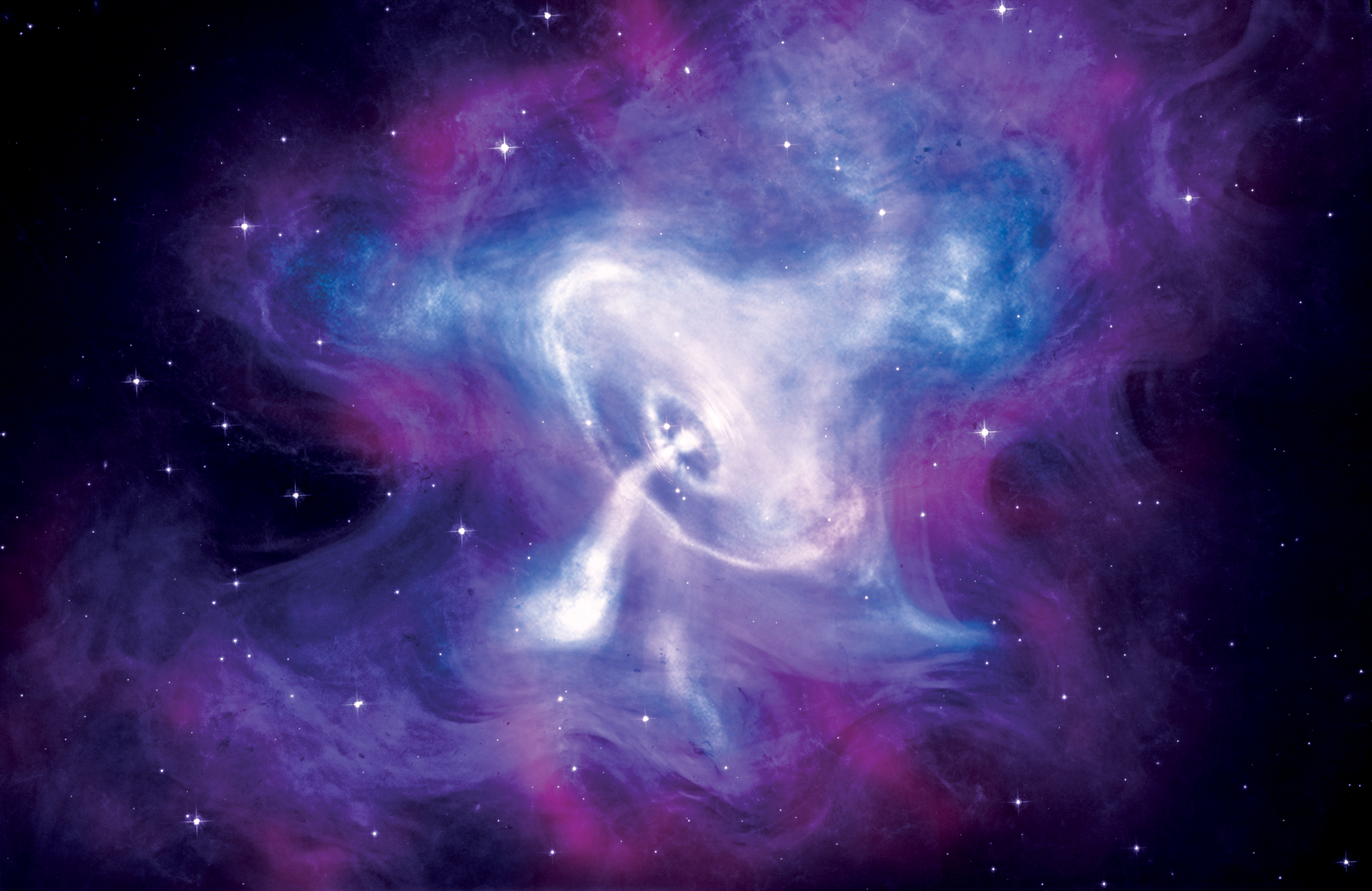
XI The Crab Nebula and its pulsar in a composite photograph constructed from X-rays observed with the Chandra telescope (blue and white), light with the Hubble Space Telescope (purple) and infrared with the Spitzer Space Telescope (pink). A spinning neutron star formed by a supernova explosion in 1054 CE generates a bright ring of high-energy particles, which leak away and probe the tangles of the nebula’s magnetic field.
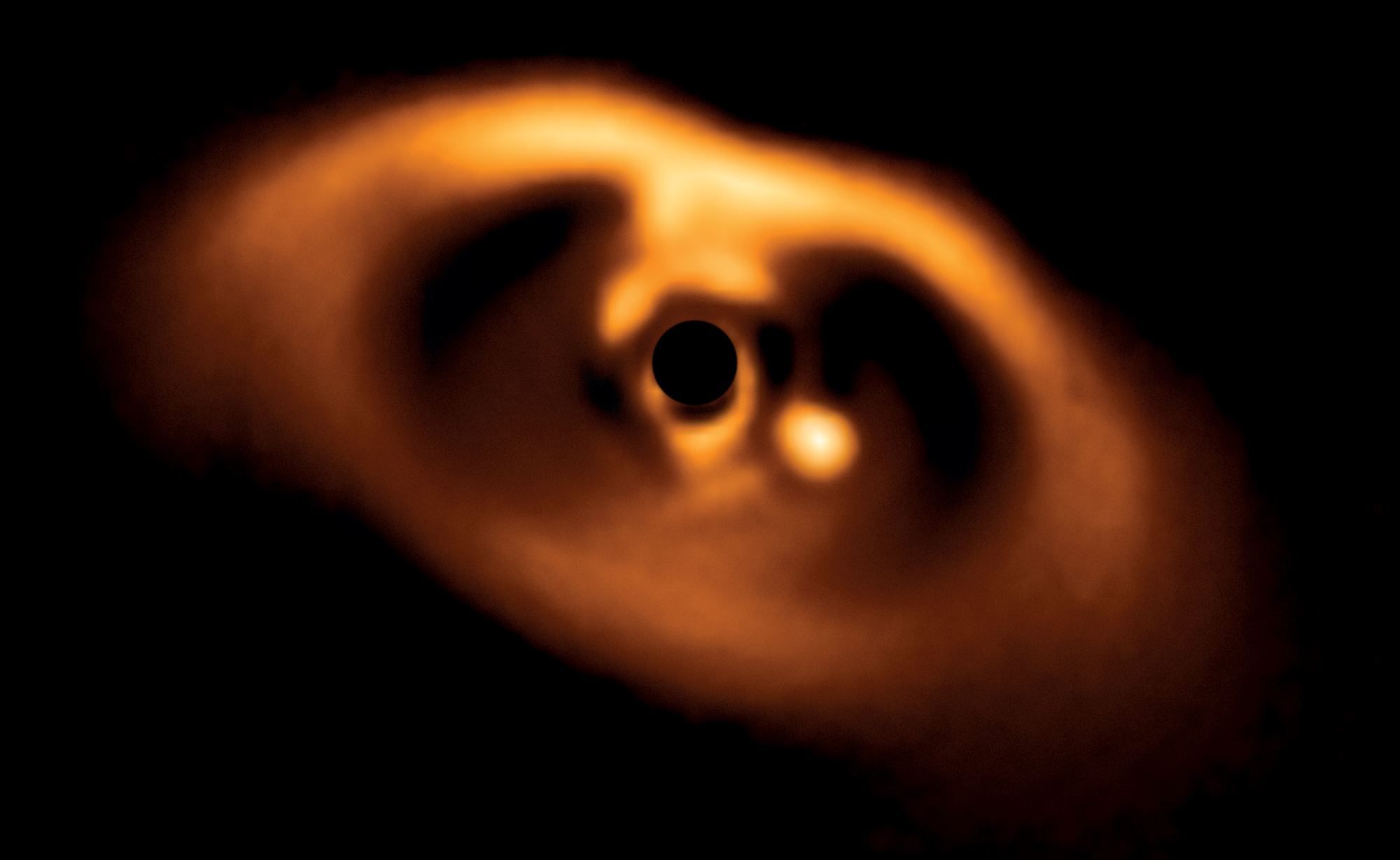
XII Exoplanet PDS 70b is the bright spot carving a path through the primordial disc of gas and dust around the very young star PDS 70, hidden in this infrared picture behind a central obstruction so that its radiation does not swamp the faint, dusty disc. The planet is more massive than Jupiter and is located roughly 3 billion kilometres from the central star, equivalent to the distance from Uranus to the Sun.
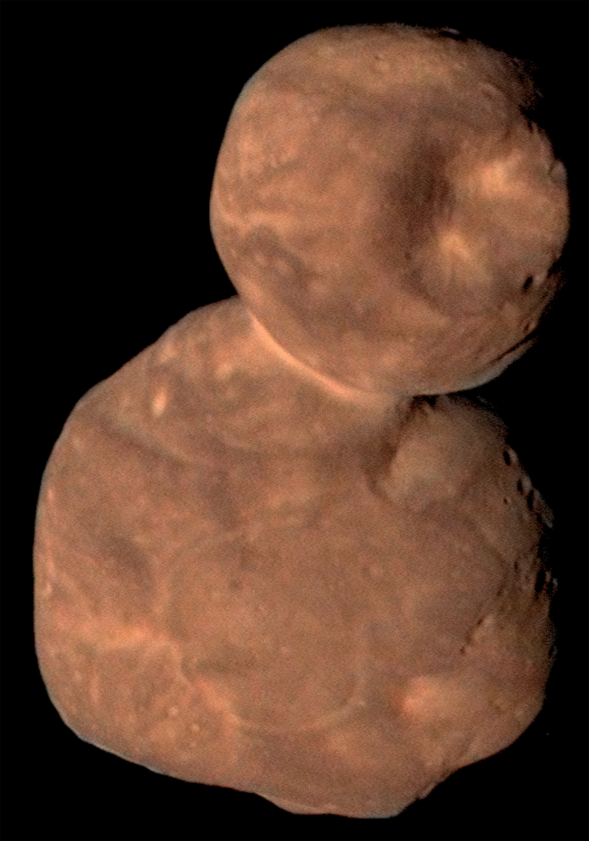
XIII Arrokoth. Orbiting the Sun at a trans-Neptunian distance, Arrokoth is a relic, 36 kilometres (22 miles) long, from the era of planet formation. Its two lobes suggest that it originated as two planetesimals that touched gently and fused at the narrow neck. Its surface is pitted with troughs and craters, some formed from impacts, others from collapsing hollows evacuated by outgassing of volatile ices.
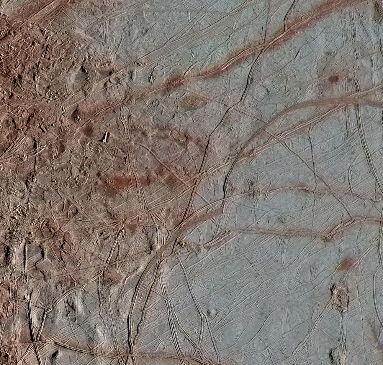
XIV Europa. The icy surface of Jupiter’s moon Europa is covered with ridges, bands, blocks and domes (on the left of this image). A flatter plain on the right is marked by arcs joined in cusps, which are fractures induced by tidal stresses caused by Jupiter’s gravity on the ice layer that floats on Europa’s sub-surface ocean.
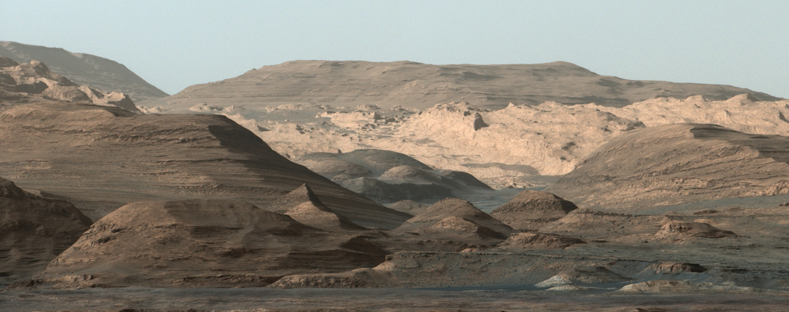
XV Gale crater on Mars. NASA’s Curiosity rover looked over a long ridge across an undulating plain rich in clay minerals, with light-toned cliffs behind. Haematite, an iron oxide, and the clay minerals in the rocks suggest how the weather changed on Mars, from a watery past to the present, drier, desert climate.
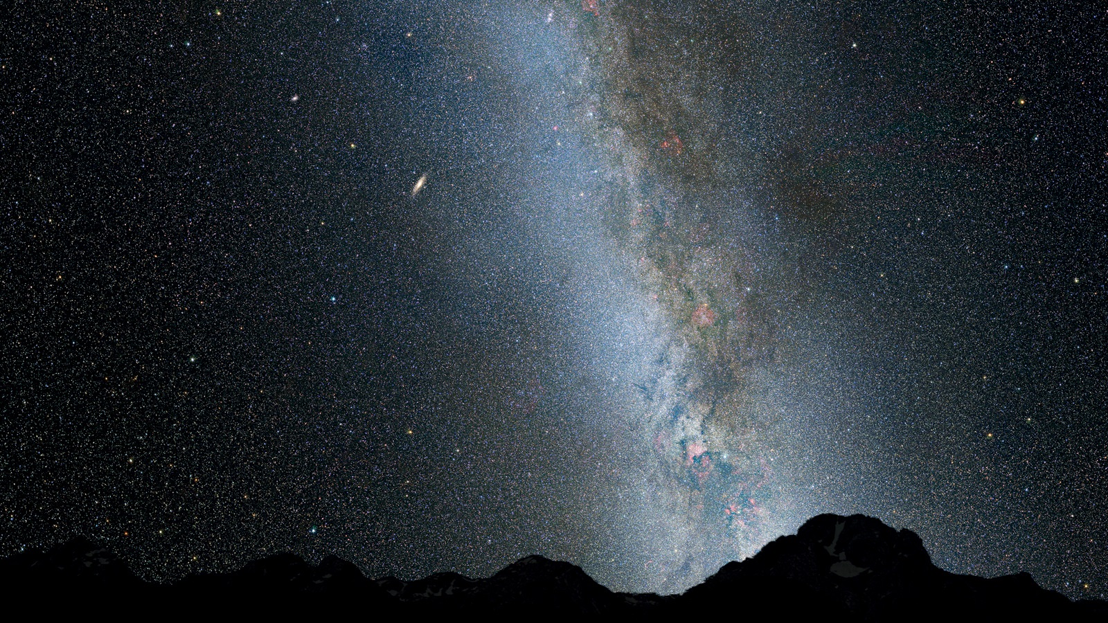
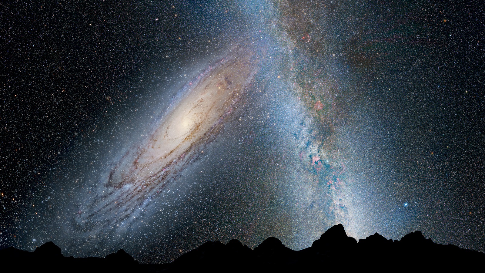
XVIa The Milky Way and the Andromeda Galaxy colliding. Images imagined from the Earth during the collision start with the Andromeda spiral galaxy far off, as now, in a line of sight that passes alongside the Milky Way.
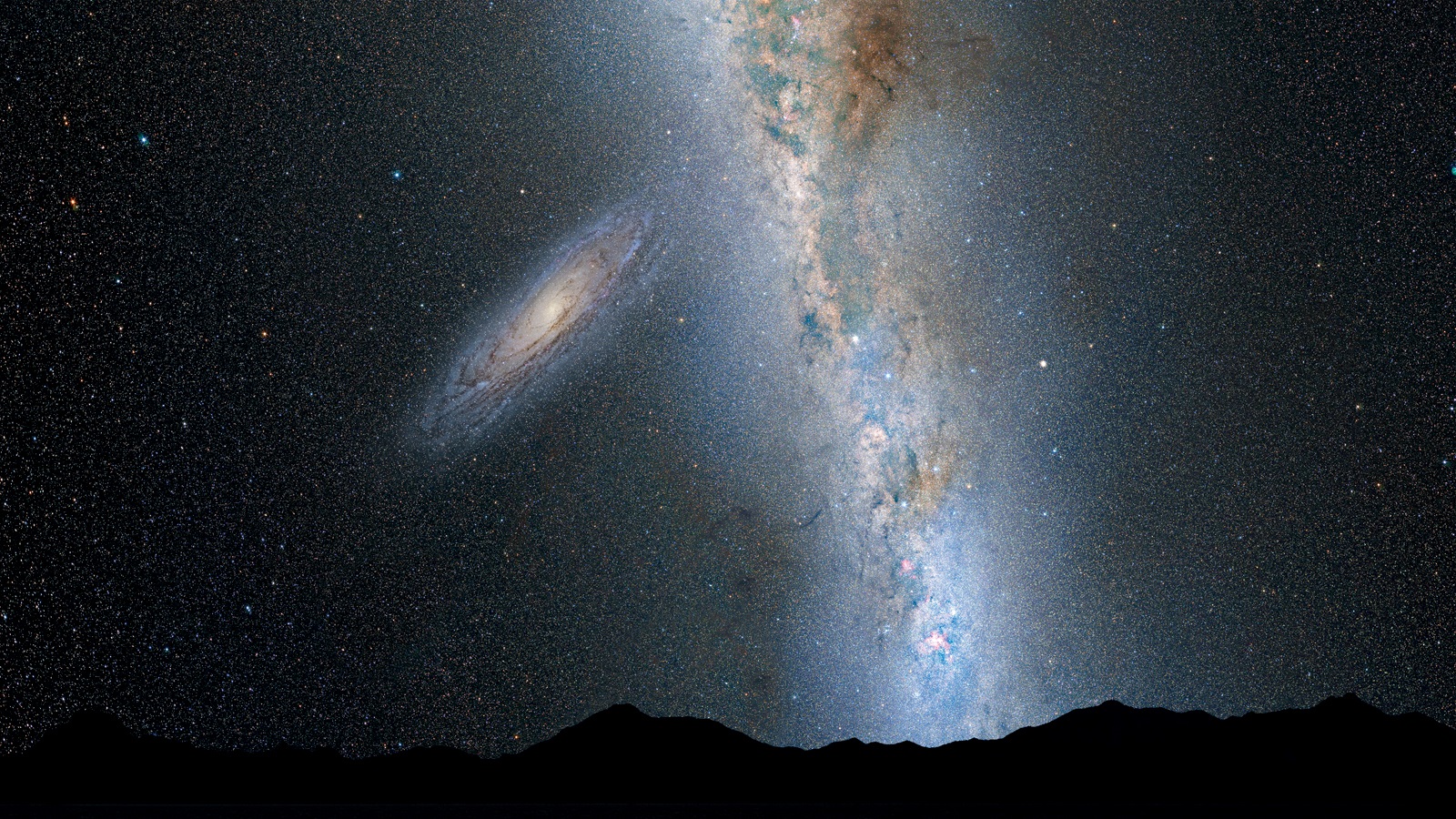
XVIb Viewed above a mountainous terrestrial horizon 2 billion years from now, the separation of the two galaxies has reduced and, appreciably nearer the Milky Way Galaxy, the Andromeda Galaxy has increased in apparent size.
XVIc By 3.75 billion years in the future, the Andromeda Galaxy looms large in the sky as it nears the periphery of the Milky Way Galaxy. The pull of each galaxy on the other has begun to distort their shapes.
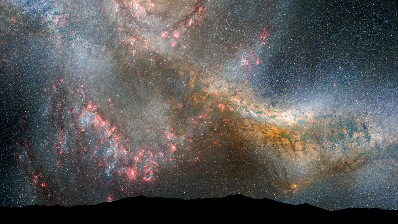
XVId The approach is accelerating at 3.85 billion years from now, and the Andromeda Galaxy fills the sky, so close to the Milky Way Galaxy that its gravitational pull has begun to trigger the formation of new stars from nearby gas clouds.
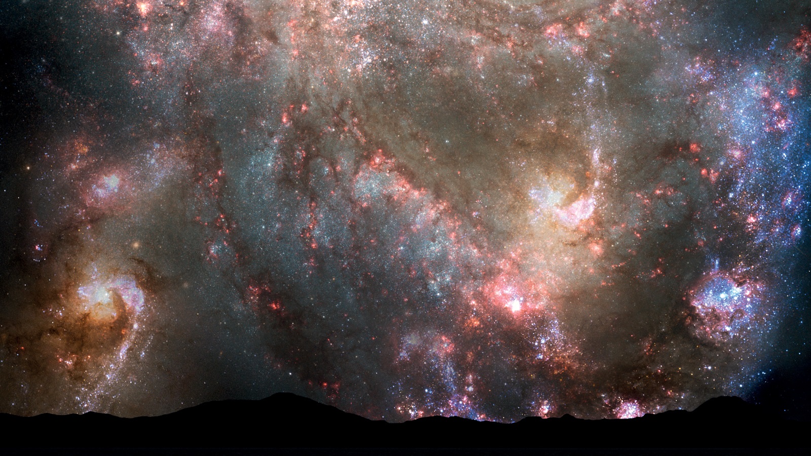
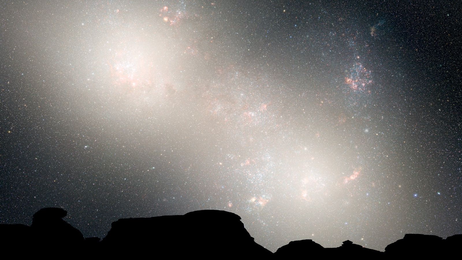
XVIe By 3.9 billion years from now, the sky is filled with new stars that shine with blue light and excite interstellar gas into its characteristic red emissions. Massive stars frequently explode as supernovae, perhaps one per year.
XVIf At 4.0 billion years from now, each galaxy has distorted the other and their original spiral structures have twisted into writhing shapes, clutching each other in a tangled embrace like lizards fighting, throwing the Sun and Earth into a distant orbit.
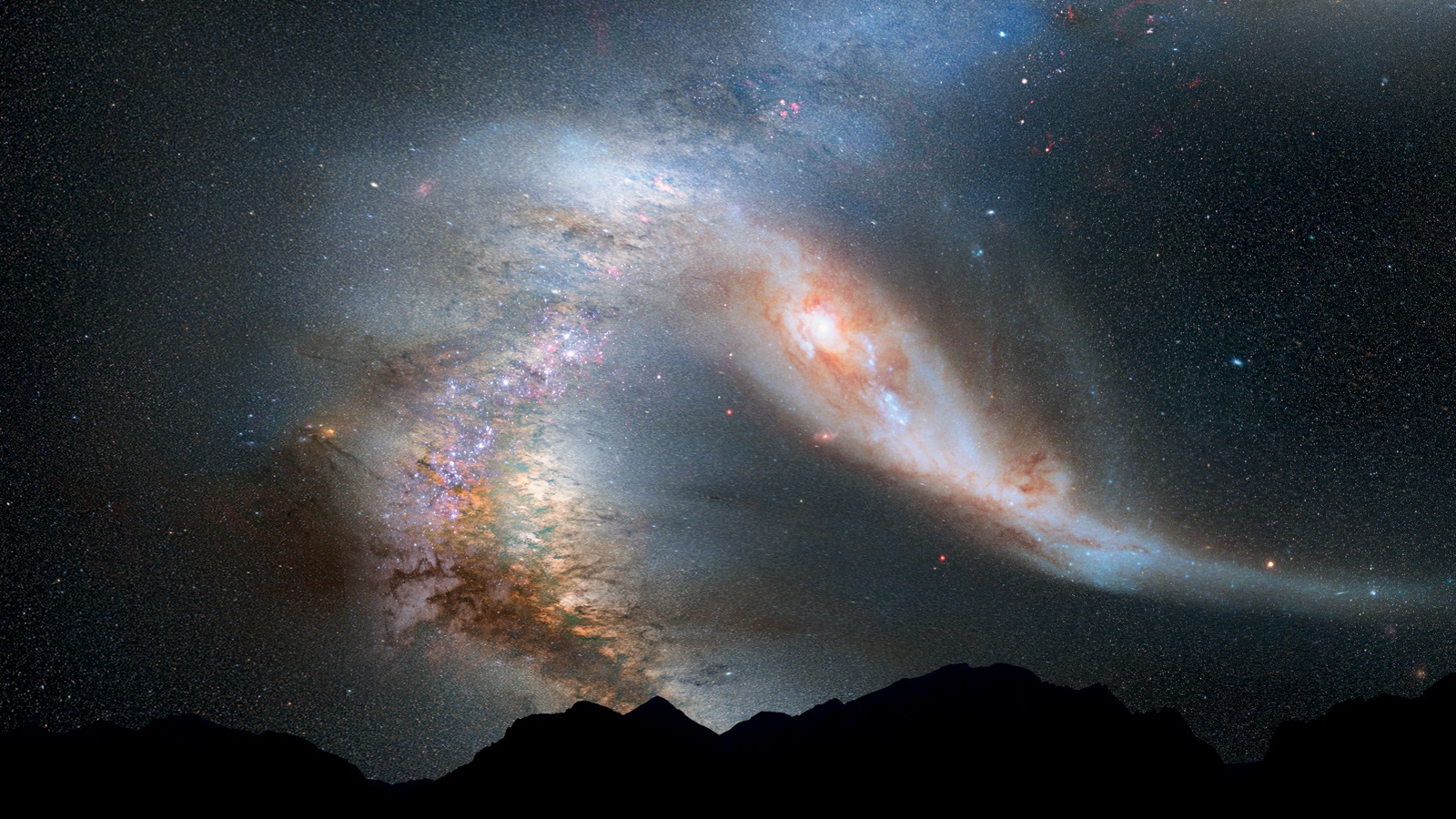
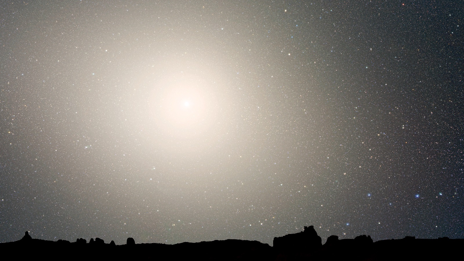
XVIg At 5.1 billion years, as viewed from the Earth, assumed here to have survived on the periphery of the action, the bright central cores of the Milky Way and the Andromeda Galaxies appear as two bright lobes, side by side.
XVIh By 7 billion years from now, the two galaxies have merged and form a huge and homogeneous elliptical galaxy. Viewed from the distant Earth, the bright core of the elliptical galaxy dominates the night-time sky but star formation has faded away.
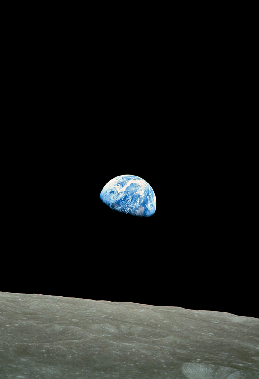
XVII Earthrise. While orbiting the Moon in Apollo 8 in 1968, astronaut Bill Anders photographed the Earth, looking beautiful but small and vulnerable, alone in space above the rocky lunar surface.