
IF THERE IS a big divide in my subject, it is between prehistory and Roman archaeology. Prehistorians like me deal with vast expanses of time, and rarely if ever see writing or inscriptions. Our approach to the past is usually deeply rooted in anthropology. Generally speaking, the repertoire of material we deal with is limited - there are, after all, not many things one can do with pieces of flint and relatively simple techniques of metalworking. Romanists, on the other hand, have to consider no more than a few centuries, but they make up for the short span of time by the breadth and depth of their erudition: for example, their ability to read obscure and invariably heavily abbreviated inscriptions can sometimes seem magical. They also need to understand coins and a vast array of intricate objects ranging from jewellery, locks and keys to imported items from the Mediterranean basin. Add to this the fact that their background will generally include ancient history, linguistics or classics rather than anthropology.
Rather than attempt a summary of Roman Britain in just one chapter, I will offer some thoughts on Roman and Late Roman Britain born of my own experiences as a field archaeologist.1 The area in which I have spent my professional life is centred on the modern city of Peterborough, which is not just a region with a rich prehistoric past: it contains some of the most important Roman sites in England, and also lies near the heart of post-Roman Anglo-Saxon England. So it is ideally suited for an examination of what was happening during this fascinating period.
One thing that immediately struck me when I first encountered the evidence for so-called Anglo-Saxon incomers in the second of the two case studies I’ll be discussing shortly, was the way they had instantly grasped how to live and farm in conditions and soils that can be agriculturally challenging. It was as if they had been doing it for years. Being a farmer myself, I know how hard it can be to come successfully to terms with new soils, land and drainage regimes. Those ‘incomers’ didn’t seem to have put a foot wrong.
Early in my archaeological career, in 1970, I worked on a Saxon site at North Elmham in Norfolk, both because I admired its director, Peter Wade Martins, and because I believed I could learn more about prehistory by working on Saxon and early medieval settlements, where much of the evidence was very similar to what one would find on a pre-Roman site. One big difference, of course, was that sites of the later periods could benefit from written sources. In fact, I learned that although the written sources told one all sorts of useful things about the way parishes were laid out, where roads went and how people resolved tenurial disputes (i.e. over land or property), it was generally impossible to relate what they said to specific structures on the ground. The written accounts did not necessarily help one decide whether the pattern of post-holes known as building A was, say, a hall or a barn - to do that, one was forced to use one’s archaeological judgement, just as on a pre-Roman site.
Before we go any further, I must pause to consider terminology. I will use the slightly long-winded term ‘Romano-British’ in the chapters that follow to describe aspects of Roman Britain. It is not a term I’m particularly fond of, but it is universally accepted, and besides, I cannot think of a better one to describe the people and the culture of Britain at the time. The term ‘Roman’ is used quite specifically by archaeologists to refer to the period of the Roman occupation from the Claudian conquest of AD 43 to the end of Roman rule, which is generally set at AD 410. This chapter will be about the Romano-British people of the Roman period in a part of Britain I know well.
Ask most people about life in rural Roman Britain and they will probably reply that it happened in villas. They may be a bit hazy about what actually went on in a villa, but columns, porticoes and bath houses with under-floor heating are usually mentioned. In fact there were not very many villas in Britain, and they occurred in quite specific parts of the country. Elsewhere, rural settlement continued much as it had done in Iron Age times.
In the 1970s and eighties I directed excavations of two small Roman hamlets in eastern England. As so often happened, they had started their lives as Iron Age settlements and continued into the Roman period. After the conquest of AD 43 they continued exactly as before, with ‘native’ or Iron Age-style roundhouses and with their farms and fields laid out as they had always been. The first archaeological indication of the Roman Conquest one comes across is the pottery. From the second half of the first century ADwe find the local hand-made Iron Age domestic pots and pans being replaced by mass-produced Romano-British coarse wares. But there is no evidence to suggest that the people using the better, harder new pottery were different in any way from their Iron Age equivalents. In fact they were probably the same individuals, or their children.
The two Romano-British settlements I excavated were both close to Peterborough, and were typical of rural communities in one of the most prosperous parts of Roman Britain. I shall describe one of them in an attempt to show what life might have been like for an average Romano-British family in this area.2 The name of the parish in which the site once lay, Maxey, comes from the Anglo-Saxon Macuseige, meaning Maccus’s Island. I say ‘once lay’ because, like many other archaeological sites nearby, it has vanished into an enormous flooded hole left by the large gravel pits that border the southern parts of Maxey ‘island’. I put the word ‘island’ in quotation marks because although the village is never flooded today, it lies on the floodplain of the River Welland, close to the point where the river enters the Fens. Consequently the land around it was subject to frequent floods in medieval and earlier times. One of the first Roman finds we made when we introduced fine-mesh sieving to our excavations in 1980 was a bone from a sprat, a fish which is at home in tidal waters.
In the past it has been suggested that the appearance of Anglo-Saxon place names like Macuseige signalled the establishment of new settlements by migrants from abroad. It is a theory that simply- and wrongly - links new names with new places. Archaeologically there can be little doubt that the good Saxon called Maccus was the last of a long line of people to link their names with this popular, flood-free place of settlement. Maxey had been a desirable area for at least four thousand years prior to the Saxon period. Occupation started there with the first clearances of the forest and the establishment of a Neolithic ceremonial site around 3800 BC, and continued, so far as we can tell, without any significant gaps until the present day.
The earliest site in Maxey Quarry was a Neolithic causewayed enclosure, a type of ceremonial and religious centre found widely across central and southern Britain. Causewayed enclosures were often located in marginal environments, presumably because they were believed to be in close proximity there to other worlds, such as the realms of the ancestors. Throughout the subsequent Bronze Age, the area continued to be revered as a special place for ceremonial and for the disposing of the dead, beneath a succession of barrows or burial mounds. Islands and water were important to the religious beliefs of both the Bronze and Iron Ages. Religion featured quite prominently in Roman and Saxon Maxey, and the fine parish church which sits atop a substantial and very intriguing mound still dominates the village. I do not believe that the selection of Maxey as a place to settle was ever just a simple matter of avoiding floods. There must also have been ideological and spiritual reasons why so many people chose to live there for so long.
What was life like in Roman Maxey? The first thing to realise is that it was never static or unchanging. Farms and houses may remain unchanged through time, but people are always altering their surroundings, often in little ways, and over the years these small changes accumulate - which is what happened at Maxey in Late Iron Age and Roman times. When we wrote up the excavations we distinguished ten distinct phases where the cumulative changes amounted to something distinctively different. For present purposes I will look at Phases 6 to 9 (late first century BC to early fourth century AD).
The first plan (Phases 6-7) shows the remains of a typical small Iron Age settlement lying above the abandoned ditches of Neolithic and Bronze Age ceremonial features, which are shown in outline. The large ditches would have served a dual purpose, both as drains and as field and property boundaries. Close to the larger ditches are the distinctive circular trenches (nos 1, 2 and 9) that acted as gutters around the outside of roundhouses. Known as eaves drip gullies, these circular features usually include a gap to allow people to cross into the main entranceway, which usually faces south-east, in the direction

Three phases in the development of the Romano-British settlement at Maxey, Cambridgeshire. Archaeological features shown in outline predate the phase being illustrated (in black).
of the rising sun.3 One tiny ring gully (no. 24) was probably dug to surround a small stack of hay or straw.
In the next Phase, 8, the settlement shifts further east, and large ditches are elaborated to form a series of small farmyards, probably for the use of cattle and sheep. There is now evidence for three roundhouses (nos 3-5) in the new easterly farmyard, but one still remains in the older yard to the west (no. 10). This phase also saw the construction of a small temple or shrine (12).
In the last Roman Phase, 9, the houses of the farmstead have been moved outside the area of excavation - probably even further east- and the farmyard has reverted to a series of small fields or paddocks, whose layout (particularly the wide entrances at the field corners) suggests they were used for the keeping of horses or cattle.
During all three periods livestock, mainly cattle and sheep, were clearly important, and they would have had access to ample grazing on the large tracts of open fenland nearby. A study of the animal bones found on the site showed that there was a surfeit of lambs over breeding ewes. This is odd, but is perhaps explained by the export of mature sheep to urban markets, where mature meat was often preferred to lamb. In the case of Maxey the nearest town would have been Durobrivae, to the west of Peterborough. Durobrivae was a very prosperous Roman small town, with markets and a thriving pottery industry. It was located on Ermine Street (the modern A1 or Great North Road), so communications were excellent. I would imagine that, just as until recently, the two or three annual visits to the livestock markets in town would have been socially important high points for farmers and their families.
Crops were also significant at Roman Maxey, and we were able to demonstrate that the small fields near to the settlement were spread with manure, which was probably derived from the bedding of animals held in barns or yards over winter. The manured fields or gardens were used to grow crops of wheat, barley, beans and peas.
Settlements of the Roman period are notable for the number of coins they reveal. There is so much information currently available that coin specialists have been able to predict what coins certain sites are likely to produce. I asked Dr Richard Reece of University College London to have a look at the five coins we found at Maxey. His first reaction was surprise verging on incredulity that we found so few, given the extent and thoroughness of our excavation techniques, which included the routine use of sieves and metal detectors - something that was still unusual back in 1979-81. He would have expected us to find coins known as radiates of the Gallic Empire (259-73) and issues struck between 330 and 348, during the reigns of Constantine I and his sons, but they were absent; instead we found an odd mix of coins which suggested, as he put it, ‘the sporadic loss of irrelevant objects, rather than a sample of normal coin-loss, and hence coin use; it may be enough to question the relevance of coins to the practical economy of the site…It could lead to a most interesting future study, perhaps best entitled “The Pattern of Coin-Loss on Coin-Less Sites’”.4
Maxey represents a small settlement of a dozen or eighteen people in perhaps two or three households. We know of at least two other, somewhat larger, settlements in the modern parish whose Roman populationmay have amounted to as many as fifty to a hundred people. So far as we can tell, these hamlets or farmsteads were near the bottom of the social ladder: luxuries were rare, but not unknown, and most of the food produced seems to have been kept for local consumption. Although the inhabitants were far from wealthy, the half-dozen bodies we recovered were generally well-nourished and disease-free, apart from some minor arthritis and one case of osteoporosis, which could have been a diet-related problem.
All in all, the impression one gains from Maxey is of subsistence, but significantly above the poverty line. Rural life would not have been easy, but it would not have lacked its rewards either: there was evidence for pinkish-red SamianWare, imported from Gaul and doubtless used ‘for best’, and we also found a number of bronze brooches, one of which had been mercury-gilded and included a jewel-like polished glass ‘stone’ setting. I have to admit that when I found it I thought it was Victorian and of little importance, so popped it into my pocket and then casually produced it in the pub that evening. When our finds specialist saw it lying on the bar, I was ordered home to put it safely under lock and key.
The archaeological world first heard about Maxey in 1960, when the huge numbers of wartime and post-war aerial photographs were assembled into a report, A Matter of Time, which showed how commercial quarrying of gravel was rapidly destroying swathes of ancient landscape in the river valleys of lowland England.5 Most of the photos were of so-called ‘cropmarks’, ancient features such as field boundary ditches, farmyards, roads, burial mounds and trackways that have been levelled by centuries of ploughing. As a result of this agricultural smoothing they only show up in growing crops, usually between May and July. Viewed from the air, especially in a dry year, the cropmarks can be spectacular, but when you visit the site on the ground it is completely flat and featureless.
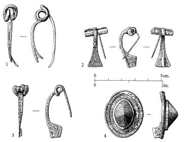
Four Romano-British bronze brooches from Maxey. Nos 1-3 are of fibula or safety-pin type; no. 4 is a mercury-gilded plate brooch with a black conical glass central inlay. Drawings by David Crowther.
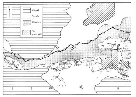
I spent a great deal of time looking through the air photos of Maxey, and it gradually dawned on me that the Iron Age and Roman farms and fields that my team had excavated once formed part of a much larger system. Although the photos showed a spaghetti-like tangle of ditches, they did seem to make general sense. First, they appeared to form two distinct ribbons of development on either side of the wide, flat valley that bounds the River Welland to the south.* Second, most of the ditches ran either parallel, or at right angles to, the river. The only clear exceptions to this were two long, straight ditches at Maxey itself, which were diagonal to the general ‘grain’ of the landscape. These two ditches belonged to a very much earlier Neolithic monument, known as a cursus, and can be discounted from the present discussion.
The more I examined the aerial photographs, the more convinced I became that most of the miles of cropmark ditches formed coherent patterns. Tracks and roadways seemed to fit in with the arrangement of fields, paddocks and farmyards. There was clear evidence too that some fields had been enlarged or subdivided, which is what one would expect from a living, growing landscape. It also accorded well with what we had observed in our excavations, where the fields were modified through time and the areas of domestic settlement drifted gradually eastwards.
It is very difficult to say precisely when this landscape came into being. One clue may be provided by a series of large Bronze Age burial mounds, often with multiple circular ditches surrounding them, which appear to be evenly spaced at roughly half-kilometre intervals along the southern part of this landscape. It’s as if some time around 2500 BC people decided that the fertile pastures of the southern Welland Valley had to be parcelled up in an equitable fashion, and enlisted the help of their dead ancestors to ensure that that the arrangement was not abused. In the northern part of the valley the first ditched field boundaries appear around 1200 BC (i.e. the later Bronze Age), but in the south true fields are not defined until the middle of the Iron Age (around 300 BC).6
It would probably be unwise to regard the Welland Valley field boundary ditches as part of a true ‘system’, in which all parts must work together for it to be effective. In some areas fields were abandoned, in others they continued to flourish and new land was taken in. What we are looking at here is a coherent pattern of landscape which includes a number of individual field systems, rather than a single field system, sensu stricto.
The beginnings of any field system are always difficult to determine with any precision, for the simple reason that once they have gone to the effort of digging ditches around their fields, farmers then try to keep them clear of silt and rubbish - otherwise they would not work effectively as drains. In the Welland Valley, where flooding can still be a problem, most farmers dig out their ditches, or dykes as they are known, at least once every seven to ten years. Every routine cleaningout of a ditch removes all the archaeological evidence that has accumulated in it since last it was dug. One is then left with a false impression of a field’s true age.
The main elements of the Welland Valley fields were, I think, in place by the end of the Iron Age, but the full flowering of the systems happened in Roman times.7 There is plenty of evidence to suggest that these fields and farms thrived well into the fourth century; but what happened then? Again, it is difficult to date with any accuracy when a field is abandoned. If, for example, it changes its use from arable to pasture, the need to maintain its drainage becomes less pressing: grass can tolerate short periods of waterlogging, and on certain freely draining gravel soils (which do exist in the Welland Valley) poor drainage is actually an advantage, especially in hot, dry summers. If ditches cease to be regularly maintained, the field can continue to function because of its hedges and fences - both of which leave little or no archaeological trace.
Once accompanying hedges have grown up alongside the ditches - a process that takes around five years - the need to retain a deep ditch as a feature of a field or farm boundary becomes less pressing.

Early field systems in the southern Welland Valley, as revealed on aerial photographs. Most were laid out in the Later Bronze and Iron Ages and continued in use throughout the Roman period.
These hedges can form features in the landscape in their own right, surviving as boundaries for many hundreds of years.8 This may be one of the reasons why earlier field systems and their alignments can survive in the countryside for so long.
There is widespread evidence that conditions underfoot became wetter in the Fens towards the close of the Roman period. Certain regions, such as my own area of research around Flag Fen in eastern Peterborough, became uninhabitable in the fifth and sixth centuries, largely due to the fact that the River Nene regularly flooded the landscape round about. That does not mean, however, that people simply abandoned everything. They couldn’t afford to. The fen margins are some of the richest grazing in Britain, and the Fens themselves are an abundant reserve of eels, fish and wildfowl: sources of the fat and protein that people must have if they are to survive the rigours of winter. There is no evidence to suggest that the inhabitants of Maxey abandoned the village at the end of the Roman period; instead they moved to somewhat higher ground, towards the centre of the ‘island’, closer to the church. What happened to the Romano-British landscape of Maxey at the close of the Roman period?
Work leading up to the publication of A Matter of Time led to a flurry of archaeological activity around the Maxey gravel quarries, and a few years ago I was given the job of editing and publishing one or two excavations that for various reasons had not made it into print.9 This work set me thinking about Roman, post-Roman and even medieval Maxey. One of the reports in that volume is about a ditched settlement with a roundhouse at a place called Plant’s Farm on what are now the western outskirts of the village. This site, which proved to be Roman, was part of the huge system or pattern of ditched fields and trackways that covered most of the southern Welland Valley. The Plant’s Farm settlement lasted well into the fourth century, and like the Roman site we had excavated in the village further east, it seems to have reached its time of maximum prosperity in this, the last full century of Roman rule.
While I was working on the new report I had frequently to dip into a much earlier publication of excavations that took place in 1959 and 1960 a short distance north-east of the church. One of the excavators, Peter Addyman, went on to achieve fame both as the Director of the York Archaeological Trust and the inspiration behind the Yorvik Viking Centre. Peter and a local colleague, Ken Fennell, did a rescue excavation in 1959 and 1960 just across the road from the church. It was published in a national journal, with admirable promptness, in 1964, and it caused a huge stir.10 At the time post-built rectangular timber buildings of the Middle Saxon period (650-800) were extremely rare, and they had found half a dozen. The site today is a flooded gravel pit.
So there was a substantial village at Maxey in Middle Saxon times, and it seems likely that its Early Saxon (450-650) predecessor lies just across the road, either in the churchyard or in the fields around it, which we know from air photos are extremely rich in archaeological features.11 A shift of such a short distance would be entirely consistent with the type of ‘settlement drift’ that is commonly observed on sites of most archaeological periods in the area, and which we saw so clearly in our own Romano-British excavations at Maxey. As I worked on the publication of the earlier digs I became intrigued by the fact that both the Middle Saxon village and the possible site of its predecessor across the road were in areas that also included ditches of the Roman system. This raised the questions of whether the occupants of the first Saxon village were outsiders from abroad, and whether there was evidence for a clear break between the Roman system of fields and yards, and the appearance of the first post-Roman village.
My immediate instinct was that occupation had been continuous. Had I been looking at air photos showing a sequence of Bronze or Iron Age settlements, I would have had no doubt whatsoever: the arrangement of Addyman and Fennell’s rectangular Middle Saxon houses precisely followed the alignment of the Roman boundary ditches. This could, of course, have been coincidence, but the excavators themselves noted that ‘These two ditches seem effectively to define the northern limits of the site, and the aerial photographs show that most of the pits [of the Middle Saxon village] destroyed [by the quarry] before excavation were within the extension of Ditch A.’12 Ditch A was a part of the Roman system and, most unusually, its bank survived up until the start of the excavation. This would strongly indicate that it served as a boundary, perhaps carrying an ancient hedge, throughout the Middle Ages.
So it would appear that earlier patterns of land allotment were influencing the shape of the Middle Saxon village. This in turn would suggest that the landscape at Maxey was still being managed by traditional rules and regulations of land ownership, which is not what one would expect to find if the population came to the area from abroad. Roman military engineers, for example, paid no heed to traditional British patterns of land tenure when they drove their long straight roads through the landscape; they had other, more pressing, concerns to worry about.
There is other evidence that the Roman and pre-Roman landscape continued to be respected in post-Roman and Saxon times. My predecessor in theWelland Valley, Gavin Simpson, also excavated extensively in the Maxey gravel pits. He quotes one example at Maxey where a Roman site probably continues into early medieval times.13 However, his best-known site was in the main Maxey gravel quarry, at a spot known as Bardyke Field, where his excavations revealed a Late Iron Age boundary ditch. ‘This was completely filled by the mid-late second century AD, yet its bank must have survived for many centuries after and became known in the Middle Ages as the Bar Dik which gave its name to one of the open fields.’14 I would attribute the survival of the earthwork to the presence along it of an ancient hedge. Gavin Simpson draws attention to other instances in the Maxey region where pre-Roman and Roman land-divisions ‘determined the layout of medieval and recent landscapes’.
Are we witnessing here the survival, more or less intact, of entire Romano-British landscapes into Saxon and later times? The answer has to be no. Even in exceptional cases, such as the extraordinary buried landscapes of West Heslerton in East Yorkshire (which I will consider in more detail in Chapter 8), there was substantial modification through time, eventually leading to the replacement of one long-lived landscape by another. Generally speaking the alignment or ‘grain’ of the developing landscapes stayed similar through time and certain key features, such as roads, remained constant; but I find it difficult to believe that a millennium and a half ago people had the energy or the resources to obliterate old landscapes wholesale, and replace them with something altogether new. It simply does not make sense, and the available evidence indicates that it did not happen.
The survival of elements of the prehistoric and Romano-British landscape into later times is not unique to Maxey. In a paper by two leading authorities on ancient fields, Chris Taylor and Peter Fowler, Chris gave several examples of recently discovered sites where Romano-British fields and boundaries survived into Saxon and later times. Peter followed with a discussion of the implications of this, and provided a significant comment: ‘Taylor…offers two options to explain a direct link in Roman-Saxon field arrangements, both assuming an Anglo-Saxon takeover; but other alternatives come to mind, not least that of Britons continuing to farm their “ancient fields” well into the so-called Anglo-Saxon period.’15
A few years earlier Chris Taylor’s Fields in the English Landscape (1975) gave many examples of Roman fields being taken over by incomers from abroad:
There is reason to believe that most medieval villages were occupied in Roman times and their fields subsequently taken over by the Saxons. However, the basic problem of exactly how the Roman fields…became the medieval or open-strip fields still remains. Can this difficulty be resolved? It must be, for the origin of the medieval field system itself needs to be understood if its history is to be seen clearly. Yet at this moment this cannot be done with any certainty and only suggestions can be made about it.16
He went on to suggest a series of rather tortuous explanations for something that at first glance seems both manifestly impossible and patently absurd. Of course the simplest explanation of all would be to do away with the idea of waves of invading Anglo-Saxons, but that would have been inconceivable even in the mid-1970s. It was one thing for prehistorians to debunk waves of nameless Iron Age immigrants from the European mainland, as they had successfully done in the previous decade; but the arrival of the mighty Anglo-Saxons on the shores of Britain was something altogether different. In the public perception, and in many archaeologists’ minds, the coming of the Anglo-Saxons changed Celtic southern Britain into England. To challenge that was to raise fundamentally important questions of national identity and self-respect; it was a nest of hornets that any scholar would hesitate to disturb. But it was the only plausible way to explain how the use of Romano-British fields continued into the Early Saxon period.
I now come to the time when my own belief in the large-scale folk movements known as the Anglo-Saxon incursions began to wobble. It happened that possibly the most important site of the Roman-Saxon succession anywhere in England was being excavated on the western side of Peterborough at precisely the same time that I was digging up large tracts of the fen margins at Fengate, on the other side of the city, to the east. That now-famous Roman to Saxon site is known in the archaeological literature as Orton Hall Farm.
As I mentioned in my earlier book Seahenge, during the 1970s I had a job in the Royal Ontario Museum which involved, among other things, my coming to Peterborough each summer to excavate sites along the edges of the Fens at Fengate, an industrial suburb on the eastern fringes of the city. In those days the government believed that many of London’s problems of overcrowding could be sorted out by the building of two rings of New Towns on green-field sites out in the country. Individual Development Corporations were set up for each NewTown to receive direct funding fromthe Treasury. Luckily the board of Peterborough Development Corporation had a conscience, and realised that the new roads, housing estates and industrial areas would cause immense archaeological damage. As a response to this threat they decided to fund a full-time archaeologist, through an already existing archaeological body who decided, with every justification, that the New Town archaeologist should be a Romanist. This made sense, as the Romano-British remains in the area were of national importance. The outskirts of the New Town would probably impinge on the outskirts and satellite settlements of Roman Durobrivae, which was the largest, and one of the more successful, small towns in Roman Britain.
The appointment was duly made, and the successful applicant was Donald Mackreth. Don had had a highly distinguished career as an excavator, particularly at the pioneering urban excavations at Winchester, and he was also an excellent draftsman and an expert on Roman brooches.17 As we have seen at Maxey, brooches occur commonly on Roman sites and can be a useful aid to dating, so Don’s expertise would prove invaluable.
The site at Orton Hall Farm had been excavated by local enthusiasts since 1964, but in the late 1960s it was announced that a large part of it would be destroyed by the construction of an intersection on the proposed dual-carriageway ring road which today surrounds Peterborough. Shortly after his appointment Don assembled a team, and work began in 1973. It was completed in 1975, just as construction of the new road was about to commence. Originally the plan had been to excavate the site in a year, but that was before its true complexity had been revealed. Don and his team worked wonders to recover such a full record of so difficult a site in just three years.
In the first two years I made repeated visits to Orton Hall Farm, and as Don or one of his supervisors showed me around we would discuss what lay before us. I remember thinking how horribly complicated the succession of different features had become as the work progressed, and how glad I was not to be digging the site myself. I was also struck by the fact that different rules seemed to apply at each end of the Roman period. At the time I had just started work on an Iron Age-to-Roman farmstead at Fengate, at the ‘start’ end of the period. Don was working on a Roman-to-Saxon farmstead, the ‘finish’ end. Yet a completely different set of interpretational criteria governed the two projects.
At my site, Fengate, there was no doubt that I was digging a prehistoric British farm occupied by Britons. After the Roman Conquest these same people decided to use a radically different type of mass-produced Roman-style of pottery, and sometimes to wear Roman-style brooches from the middle of the first century ad. They also ceased making old-style Iron Age pottery, which stopped quite abruptly when the first Romano-British mass-produced alternatives arrived on site.
Something very similar was happening on the other side of the city, at Orton Hall Farm, except this time the changes were the other way about: the pottery changed frommass-produced to hand-made, and ornaments changed from Roman to ‘Anglo-Saxon’, in particular a characteristic type of sleeve fastening known as a wrist-clasp, which works on the principle of the modern-day bra fastener, with a flattish hook and an elongated catch-plate or slot. It’s a practical type of fastener that can easily be done up or undone single-handed.What I failed, and still fail, to understand was why the changes in archaeological artefacts, which were so similar at both sites, were attributed on the one hand to Roman ‘influence’, and on the other to Anglo-Saxon incoming ‘settlers’? In other words, the changes observed at the earlier site involved the movement of ideas, and at the later of people. But why?
These thoughts troubled me for a while, but then I found myself busily engaged writing the academic report of my work at Fengate, and any ideas about what may or may not have happened in post-Roman Peterborough had to take a back seat. I thought no more about such things until 2001, when I set about writing Britain BC, a process that involved rereading various papers that debunked the Iron Age Celtic ‘invasions’. As I read, all my doubts about the Anglo-Saxons re-emerged, but by now the archaeological climate had changed radically, and I found that my views were not only non-controversial, but quite widely accepted by leading authorities on the Anglo-Saxon period. It was quietly satisfying to know that I had come to them myself, independently, back in the early 1970s.

Orton Hall Farm, Peterborough: simplified plan of the Late Roman farm (Phase 4 c.225/250-c.375).
Let’s have a closer look at Orton Hall Farm to see precisely how the Anglo-Saxon phenomenon affected the archaeology of an otherwise unexceptional Romano-British farmstead. As I have already noted, this area of Roman Britain was prosperous. Most of the wealth seems to have been based on the products of farming, and Roman Orton Hall Farm appears to have been a great deal more prosperous than either contemporary Maxey or Fengate. It’s hard to suggest an obvious reason why this should have been so - distance from the regional centre, the market town of Durobrivae, may have been a factor, but the simplest explanation would be that the Romano-British rural landscape, like landscapes before and after it, included farms of many different shapes and sizes. Orton Hall Farm was one of the larger and more successful of them.
There is evidence for pre-Roman activity on the site, but it’s pretty scrappy: a small pond which was shifted sideways and enlarged in Roman times, and a few ditches which may have formed parts of
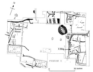
Orton Hall Farm, Peterborough: simplified plan of the Late Roman and ‘Anglo-Saxon’ farm (Phase 5: c.375-early sixth century).
fields, paddocks or even yards. Unlike Maxey or Fengate, there was no Iron Age farm or settlement directly beneath the Roman farm, although there was evidence for early settlement nearby. The farm gets going in earnest in the mid-first century AD, shortly after the Roman Conquest. Like most farms of the Early Roman period, it included a number - up to five or six - of roundhouses of traditional or ‘native’ Iron Age type. Donald Mackreth assigned the first Roman farm to Period 1, which ended around AD 175.
In Periods 2 and 3 (c.175-300/325) the farm becomes larger, and the space it occupies is transformed into a large ditched farmyard with a series of buildings around its periphery. Stone buildings appear for the first time in Period 3 (around 225/250), and the farm settles down: buildings cease to be shifted and become more static through time. By Period 4 (c.300/325-375), i.e. during the fourth century, which Guy de la Bédoye`re christened the Golden Age of Roman Britain, Orton Hall Farm was having its own little Golden Age. During this period the farm acquired its own rectangular mill-house. Period 5 (c.375-early sixth century) covers the gradual diminution of this, along with the arrival of Anglo-Saxon settlers at some point.18
The Orton Hall Farm stone buildings were comparable in size to barns and outbuildings of more recent periods. I’ve visited small working upland sheep farms where the yards and buildings were a great deal less substantial. We’re certainly not looking at a small-scale subsistencetype operation; whatever else, Orton Hall Farm, in both its Roman and ‘Anglo-Saxon’ phases, was a significant enterprise. It’s also interesting, as Dr John Peter Wild has pointed out, that the owners of Orton Hall Farm decided not to plough back their profits in flashy display - such as mosaics or painted wall plaster.19
The argument for the presence of so-called Anglo-Saxon settlers does not rest on the appearance of new styles of pottery and fashion accessories, such as brooches and sleeve fasteners, alone. We also see the introduction of new styles and patterns of buildings, just as we witnessed in Early Roman times. At Orton Hall Farm we see the appearance of a very distinctive ‘Anglo-Saxon’ building known as a sunken feature building (SFB), or Grubenhaus, to use the German word (which rather instructively became the standard English term for these Continental-style ‘pit dwellings’). A Grubenhaus is a small, squarish rectangular (the archaeological term is sub-rectangular) building which is characterised by a hollow or pit-like space beneath the floor. These pits can be half a metre or more deep. At either end of the pit is a hole for a post which supported the roof ‘s ridge-pole. Similar buildings are found right across northern Europe in the fifth to seventh centuries AD, but they are particularly common in Britain.
I will discuss their function in Chapter 8, but here I want to note the presence of one within the bounds of a Late Roman farmyard, just outside a ditched yard which contained the post-holes of a small ‘Anglo-Saxon’ hall at Orton Hall Farm. Mackreth dates this SFB to the late fifth century at the earliest, and provides good evidence to suggest that it had fallen into disuse before the abandonment of the main farm in the early sixth century. The presence of a very early SFB is interesting, but its position outside what seems to have been a specifically domestic enclosed space suggests it was used as a farm building, not as a house.
The Romano-British house of Periods 3-4 was rectangular, made of stone and measured about twenty-five metres long by just over eight metres wide. Mackreth had problems defining its precise size because the walls had been ‘robbed out’ (an archaeological term to explain the removal - ‘robbing’ - of stone from an abandoned building for use elsewhere). But he was able to demonstrate clearly that the place of the Roman stone building had been taken by an ‘Anglo-Saxon’ hall-type rectangular building, made from timber.20 As we saw in the Iron Age/Roman overlap, the introduction of stone to replace timber does not have to involve the replacement of the resident population. It is merely a change of building technique. With the decline of Roman influence and the breakdown of formal trading networks in the fifth century it is hardly to be wondered at that people reverted to a more traditional and readily available building material.
It is worth noting here that the most characteristic Anglo-Saxon domestic building, the so-called ‘aisled hall’, has interesting origins. We will see examples of these buildings later, at places as diverse as Maxey, near Peterborough, and Birdoswald Fort on Hadrian’s Wall. Saxon aisled halls are traditionally believed to have been based on Continental buildings, but in fact aisled structures (i.e. buildings with two rows of roof-supporting posts in the interior) are probably the commonest form of building in rural Roman Britain. They usually occur in the form of a barn - as at Orton Hall Farm - or a house. In some instances the open-plan hall acquired partitioned-off spaces at one end, as also happened in medieval times, when the principal family began to feel the need for greater privacy. It seems to me far simpler to derive the Saxon aisled hall from the Romano-British aisled building than from parallels abroad. The only significant change is the shift from stone to wood - or from stone back to wood, if we bear in mind what was happening in pre-Roman times.
It might be supposed that the Roman to Anglo-Saxon sequence at Orton Hall Farm was a one-off, but it was not. As Don Mackreth noted in 1977:
There was a time when it was thought that Saxons shunned Roman buildings as works of evil forces. This view was to a large extent based upon the apparent lack of Saxon finds on Late Roman sites.
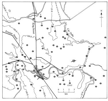
Roman settlements in the lower Nene Valley around the town of Durobrivae. The site at Orton Hall Farm is shown as ‘OHF’; settlements that have produced Roman and Anglo-Saxon pottery are marked ‘S’.
In recent years knowledge of Saxon domestic pottery has greatly increased and many sites with a Saxon presence are now known.21
A large number of Romano-British settlements are known around Durobrivae, and several include both Roman and Anglo-Saxon pottery. One site currently being worked on at Haddon, close by the modern A1, is producing quantities of Anglo-Saxon pottery that dwarf the substantial assemblages found at Orton Hall Farm. It goes against common sense to believe that the changes we are witnessing here reflect the replacement of one population by another. Frankly, if I were a prosperous Late Roman farmer living with my family in the lower Nene Valley and I saw boatloads of settlers sailing up the river with the express intent of taking over my farm, I’d put up a fight. I’d organise a militia with my neighbours. I’d do anything. But it would appear that they handed over their farms without a struggle.
Much of the phasing at Orton Hall Farm was worked out by Donald Mackreth in close collaboration with Rob Perrin, an authority on Romano-British pottery. Rob’s report on his role in the detailed phasing of the site contains a revealing sentence: ‘The phasing process was largely dependent on pottery dating, although the site showed a clear, logical development in layout and structure which provided a good framework into which the dating could be placed.’22 That seems to me as clear-cut a statement as one could possibly wish: there is no mention of the disjunction, separation or misalignment that one would expect had the farmbeen taken over by an incoming population of new settlers. Quite the contrary, in fact. To my eyes the arrangement of the farm, in all its phases, seems consistent and logical, whether it is growing or decreasing in size. I know from my own experiences as a farmer that such development only comes fromliving andworking in the same place over an extended period of time.When youmove into a new place, things change: you see the farm through fresh eyes. Sometimes you get things right, sometimeswrong, but you never continue preciselywhere the previous owner had left off. People simply do not behave like that. It was good to have this feeling confirmed by someone so intimately associated with the day-to-day minutiae of the pottery phasing.
I will leave the final words on the Roman/Anglo-Saxon succession to DonMackreth himself. Clearly he believes in the idea of an incursion of settlers, but he has trouble reconciling this concept with the evidence in the ground. Being a conscientious archaeologist, he expresses those doubts clearly, and I quote his words at some length because they sum up well the practical difficulties of pinning down those wraithlike, shadowy figures who were supposed to have swept across eastern England in the fifth and sixth centuries AD:
The only tangible evidence [at Orton Hall Farm] for a direct interaction between Roman and Anglo-Saxon is a sherd from a mortarium in an Anglo-Saxon fabric*…There were Roman goods in use during undoubted Anglo-Saxon occupation, but no final evidence that these had not been gleaned from elsewhere. Otherwise, the argument for close association of the two cultures rests on a possible chronological overlap between latest Roman material and earliest Anglo-Saxon…No feature sustains the view that the Anglo-Saxons used a Roman site in full working order, but the accumulation of detail…leads inexorably towards that view.
There is no incontrovertible evidence that there had been a distinct break in occupation: too many of the proven Anglo-Saxon features only make sense if Roman structures were still standing. The impression is that the Romanised site had become debilitated before the Anglo-Saxon pottery arrived, but it was not possible to show that this must have happened before Anglo-Saxon occupation of all or part had become established.23
Mackreth’s statement that ‘the only tangible evidence for a direct interaction between Roman and Anglo-Saxon is a sherd from a mortarium in an Anglo-Saxon fabric’ is important from two points of view. The first, rarely remarked upon by archaeologists who are sometimes more interested in dry fragments of pottery than in spicy food, is what one might term ‘culinary continuity’. Roman cooking frequently involved the grinding of spices and condiments in a pottery mortar (‘mortarium’), and it was a style of eating that the British rapidly took to, if we are to judge from the large numbers of worn-out mortarium fragments that occur on Romano-British domestic sites of even the humblest sort. One might suppose that an incoming Anglo-Saxon population, that had no Romanised traditions of its own, would have had quite different styles of cooking. But apparently not. It would seem that they liked the food of the people they overran so much that they went to the trouble of imitating a Roman mortar in their own pottery workshops. Froma human, if not from a strictly archaeological, perspective, this strikes me as very odd.
If you remove the concept of the Anglo-Saxon settlers, the picture painted by Mackreth is of a Romano-British farm adapting to new economic circumstances brought about by changes in the political landscape of the late Western Empire. I do not believe that Mackreth is raising the point, but it has been suggested that farms like Orton Hall Farm became less economically efficient in late - and post-Roman times. Certainly there would have been changes: stone buildings were replaced by wood, and hard, factory-produced Romano-British pottery went out of use. There may also have been a move towards increased reliance on stock-raising. These changes may have reflected the fact that access to national distributional networks via markets at places like Durobrivae was starting to break down towards the end of the fourth century, but they do not suggest that the farm itself was in decline as a farm. The changes in what is today called the ‘macroeconomic climate’ must have caused places like Orton Hall Farm to turn towards local trade, which initially would have been based more on barter than money. The farm, like the rural population of eastern England as a whole, had become rather less Roman and rather more Iron Age and self-reliant.
Recent excavations at Quarrington, an Early toMiddle Saxon settlement near Sleaford, thirty-five miles north of Orton Hall Farm, have revealed some extraordinary results that challenge the idea that life in Early Saxon communities was as isolated and self-reliant as was once believed. The site revealed a large amount of Early and Middle Saxon pottery: over 2,330 fragments. The clay and other material added to the mix, or ‘fabric’, of the pottery was analysed and found to come from a wide range of sources: ‘In the Early Saxon period, the fabrics at Quarrington are known to have come from southern, northern and central Lincolnshire as well as from Leicestershire.’24 I suppose it would be too obvious to ask how these people, who we are told had only recently come to England, managed to establish such extensive trading networks so soon. I think it goes rather further than that. It is not just a question of ‘trading networks’, because we are dealing here with dispersed rural economies that were operating outside what we would regard today as a market economy.
Professor Martin Millett has concluded that even at the hub of the Empire, trade between Rome and the provinces ‘was exchange demonstrably embedded within the social and political system’. He goes on to point out that much of the large-scale movement of goods, such as the provision of supplies to the army, was actually motivated by reasons that were more complex than free trade. ‘These patterns develop in such a way as to demonstrate that the system was not simply a function of unbridled economic forces.’25
If the ‘trade’ that was so characteristic of the Roman monetary economy was not simple free trade, what was it likely to revert to when the Empire collapsed? One thing we do know about pre-Roman British economies is that they did not operate on the basis of trade at all. To use Martin Millett’s phrase, it was ‘exchange demonstrably embedded within the social and political system’. Only this time the political system was the social system.
I suspect that in post-Roman, as in pre-Roman, times, goods and commodities were given or exchanged as part of short - or long-term social obligations. Maybe one farmer paid another for the use of land by giving seed corn; the practice of giving ‘bridewealth’, or goods and services as part of a marriage agreement, would have knock-on ‘trade’ obligations that would continue for years. Powerful men would expect tribute in some form from their followers, and so on. The list is endless.
I believe that the operation of ‘socially embedded’ exchange networks continued throughout the Roman period and into post-Roman times, and may well help to explain the survival of certain traditional trading places into the fifth and sixth centuries (as we will see in Chapter 7). Such exchange networks take generations to build up, and Quarrington may not have been as exceptional as at first it appears. The expert on Anglo-Saxon pottery J.N.L. Myres, for example, produced convincing evidence for the existence of pottery workshops, whose cremation urn products appear in more than one cemetery.26 Surely, of all things, the distribution of cremation urns has to be ‘socially embedded’.
I would view the fourth to sixth centuries in eastern England as broadly similar to the first centuries BC and AD, with an essentially stable rural population existing in a political context that was changing quite rapidly. The population appears to have grown from Early to Middle Saxon times, to judge from the internal development of numerous rural sites like Quarrington.27 ‘Socially embedded’ exchange networks, both in Britain and overseas, were certainly allowed to develop - indeed to thrive. All in all, I can see no convincing archaeological evidence for ‘Dark Age’ chaos, disruption and turmoil.
*At the time, aerial photographs of the area north of the river Welland were not readily available for study.
*A mortarium is a kitchen mortar or grinding bowl. The term ‘fabric’ refers to the mix of clay used to form the mortarium. Pottery fabrics are a very reliable way of identifying different styles and traditions of pottery manufacture.