ARCHAEOLOGISTS HAVE to read a lot. All too often the written style of what I have to read is dull, but the results of the research usually compensate for the stiff, jargon-ridden prose one has to wade through. Such reading is a duty, rather than a pleasure, and it has become a dreary fact of modern archaeological life. But there have been some notable exceptions - archaeologists who can really write - and of those my favourite is the late, great W.G. Hoskins, whose book The Making of the English Landscape (1955) is a masterpiece that changed the course of my archaeological life.1
Having read Hoskins, I knew that only one thing really mattered to me, and that was to understand what made ancient landscapes, and the people who lived in them, work. Hoskins saw the landscape as being inspired by past minds and imaginations; it was not merely a creation of hard labour influenced by practical considerations, such as the need to farm or to travel. He saw the influence of the Church in the development of the medieval landscape, and he sought evidence for social relationships, such as that of landlord and tenant, in the way, for example, that villages were arranged, fields enclosed or towns laid out. His landscape was a human phenomenon, and he wrote about it with extraordinary warmth, even when he was being analytical.
Hoskins wrote The Making of the English Landscape in the 1950s, and his views on the earliest landscapes are very much a reflection of that time. It was believed, for example, that there had been relatively little clearance of the forests that covered most of Britain before the Roman Conquest:
The clearance of the woodland was, indeed, the greatest single form of change in the natural landscape, especially in the early stages of the Old English [i.e. Anglo-Saxon] settlement before there was any thought of draining the waterlogged fens and marshes.2
The notion that the Anglo-Saxon ‘settlers’ cleared the forests of eastern Britain went hand in hand with the idea that these people were pioneers, reminiscent perhaps of those stout Englishmen who had settled the woodlands of North America.3 Unfortunately for that view, we now know from numerous excavations and from surveys of past vegetation using pollen analysis that most of lowland Britain had been cleared of tree cover by the end of the Bronze Age, around 1000 bc.4 While large tracts of forests undoubtedly remained, massive or wholesale clearance was not necessary after the Roman Conquest: it was more a matter of eating away at the woodlands, a process known in medieval times as ‘assarting’.5 The substantial areas of woodland in post-Roman Britain were in places like the Forest of Dean. They were less often found on the eastern side of the country where the Anglo-Saxon ‘settlers’ were supposed to have hewn out their clearings and established their homesteads. That work had been done for them two millennia previously.
The ancient woodlands of Britain were an important resource that did not necessarily need to be ‘cleared’. It was they that provided the timbers used in the construction not just of Britain’s many churches and great cathedrals, but her humbler houses and cottages too. Far from being a subject for ‘clearance’, they had been managed with great skill since at least the Neolithic period, five thousand years ago, to provide forest products ranging from willow basketry to large poles and heavy timbers.6
When reading accounts from the 1950s and before of how Anglo-Saxon incomers cleared the forest cover that then cloaked large areas of south-east Britain, it is hard to avoid the between-the-lines suggestion that these diligent, hard-working new arrivals did what the ‘native’ Celtic communities ought to have done centuries earlier, were they not so indolent by nature. Hoskins accepts the Anglo-Saxon invasions as fact, but he clearly recognises that there are problems in reconciling the received historical account with what he has observed in the field. I suspect that were he still alive, he too would be a part of the anti-massmigration tendency in the world of Anglo-Saxon studies. He starts his second chapter, on ‘The English Settlement’, with a statement of the then current view that ‘the Old English swept all before them and built and planted afresh’. He then goes on to say: ‘But this picture is far too simple and does not square with the facts…hamlets and isolated farmsteads of great antiquity can be found dotted about the Midland[s] and the eastern counties.’
Hoskins even casts doubt on what was then the ‘big idea’ of Anglo-Saxon studies. It had been believed for some time that the thousands of villages that are today such a pleasant feature of the English countryside were a product of the Anglo-Saxon settlers. This notion was first put forward in a detailed and thorough country-wide study by the great nineteenth-century economic historian Frederic Seebohm. I was introduced to his work as a child, because the Seebohm family lived near the farm in Hertfordshire where I was brought up, and my best friend was also called Frederic Seebohm. Young Freddie showed me a copy of his august ancestor’s great book The English Village Community (1883), which began with a study of the villages around Hitchin, our local town.7 I found a copy in my grandfather’s library, which I promptly ‘borrowed’ - and I have it beside me as I write. There is nothing like local and personal interest to fuel one’s enthusiasm, and I spent many weekends on my bike visiting the places described by Seebohm, which were sometimes, but sadly not always, still there.
Both Seebohm’s and Hoskins’s books will continue to stand on their own merit as works of great scholarly insight, whether or not Anglo-Saxon invasions actually happened. But it is interesting to detect that Hoskins plainly had his doubts that villages were, of themselves, an indication of Anglo-Saxon settlement. To quote again from the first paragraph of Chapter 2, he notes that ‘Even in Cornwall and Devon [both counties well outside the Anglo-Saxon area], in the far southwest, the large compact village can be found all over the map and is found at the time of the Norman Conquest.’ In other words, Hoskins is plainly saying that large, compact ancient villages cannot be linked to ‘Dark Age’ incomers.
Hoskins was also of the then common opinion that Anglo-Saxon place names indicated new settlements established by incomers. was by no means alone in this view. As late as 1991, A.D. Mills in the Introduction to his excellent Dictionary of English Place Names for Oxford University Press was able to write:
The Anglo-Saxon conquest and settlement of Britain began in the fifth century ad, spreading slowly from the east to the west and culminating in the occupation of the whole of what is now England …by the ninth century. These new settlers were the Angles, Saxons and Jutes, Germanic tribes from northern Europe whose language was Anglo-Saxon, now usually called Old English to emphasise its continuity with Middle and Modern English.8
It was even suggested that these new settlements could be given some sort of chronological sequence by the type of language employed. Names that included the elements ‘ham’ or ‘inga’ - Birmingham, for example - were thought to be early in the sequence, thus providing evidence that the incomers penetrated quite rapidly into the East Midlands.9 In the last fifty years, however, archaeology has demonstrated that the new Anglo-Saxon names were actually given to places that had been in existence very much earlier (as we saw at Maxey in Chapter 4). The names are of interest in their own right, but should not be treated as reliable evidence for when a particular town or village was actually founded.
The traditional view of the ‘Dark Age’ British countryside is of a place where the landscape reverted to scrub and woodland following the collapse of the Roman Empire. But we have already seen that the fourth-century ‘Golden Age’ was essentially a rural phenomenon, and there is no evidence to suggest that the countryside ‘collapsed’; indeed, if anything, rural settlement went from strength to strength. Similarly, the idea of living in large, close-knit (or ‘nucleated’) villages surrounded by the fields and pastures of what was to develop into the well-known Open Field system of the Middle Ages, had its origins in Late, not Early Saxon times.10 Early Saxon villages, as we saw at Maxey, were essentially a continuation of Romano-British and Iron Age settlements. Nicholas Higham describes the situation clearly:
This continuity of habitat and rural activity is a crucial component of our revised perception of the Romano-British/Saxon interface and is entirely incompatible with the notion of wholesale depopulation on the eve of, or in the course of, Anglo-Saxon settlement. Nor did Germanic immigrants bring with them ready for use the ideas of living in a nucleated village or cultivating open fields… The excavation of deserted medieval villages slowly revealed from the 1950s onwards that the process of settlement nucleation by which they came into existence was, at earliest, a late Anglo-Saxon phenomenon. Many instances post-dated the Norman Conquest.11
I recall the first time I came across solid scientific evidence that the end of the Roman period did not witness a collapse in the rural economy, even in those parts of eastern England which were supposed to have received the earliest Anglo-Saxon raids. It was in a paper published in 1994 by an old friend and colleague, Peter Murphy, with whom I had worked on a number of projects in and around the Fens. One would suppose that boatloads of Germanic warriors wielding their fearsome swords and those ‘strong knives, commonly called scramasaxes, smeared with poison’12 would have caused stalwart East Anglian farmers to pause momentarily from their labours. But apparently not.
Peter, who has been studying the changing environment of eastern England for many years, looked at sites of the Early Saxon period in Essex and East Anglia.13 He was interested in testing the idea, current in the 1950s, that the more intensively farmed areas of the Romano-British landscape reverted to scrub and woodland after the Roman period. In theory at least the Anglo-Saxons then arrived and set about the task of felling the trees. He quotes Dorothy Whitelock (writing in 1952), a well-known authority on the Anglo-Saxons, who wrote that the Early Saxon landscape was ‘heavily forested…areas under cultivation were on the whole small, surrounded by woodland and waste’.14 Why is it that the pejorative word ‘waste’ seems so inextricably attached to earlier views of the period? Personally, if I was part of a mass migration I would rather jump ship than farm a ‘waste’.
In 1986 Oliver Rackham, the acknowledged expert on ancient woodlands, contested the idea that regrown (or secondary) woodland had established itself at the end of the Roman period.15 His rebuttal of the traditional view was based on his knowledge of early maps and place names. Peter Murphy looked for solid scientific evidence to decide the matter finally. He chose three distinct types of landscape for his study: the coastal marshes of Essex, the river valleys of central Essex and the sandy Breckland of West Suffolk. His research was broadly based, and made use of plant remains (usually carbonised fragments from around ovens, hearths and bonfires), pollen grains and soil science. He took great pains to exclude any samples that might not derive from securely dated deposits. It was a model study of ancient environments.
Peter found no evidence for secondary woodland at any of the sites in his three areas. He did, however, find clear evidence that in some areas the intensive production of cereals, which had been a feature of the Romano-British economy in East Anglia, had given way to livestock farming in the fifth to sixth centuries. This would suggest a change in the rural economy from an intensive system in Roman times, intended to produce a surplus of grain to feed the urban population and the army both abroad and in Britain, to something much closer to subsistence farming. He noted, however, that the Iron Age and Roman field systems seemed to have continued in use, which might well suggest that the pastoral farming was larger in scale than mere subsistence. I strongly suspect that something very similar was also taking place further north, in the area around Maxey and Durobrivae.
One advantage of such a broadly based study is that it allows us to gain a glimpse of the way in which the Early Saxon landscape was managed in general. Peter concluded that Anglo-Saxon agriculture was very diverse: ‘On the Essex coast an economy based on salt-marsh sheep-grazing may be inferred; in the Essex river valleys an economy in which oat cultivation on heavy soils seems to have been important; at Brandon [in the Breckland] an arable economy based on ryegrowing …with flax production in the river valley.’16
The point that arises from this is obvious, but needs making nonetheless. This diversity of land use shows an extraordinary degree of adaptation to contrasting landscapes and soil conditions, at precisely the time when Anglo-Saxon settlers are supposed to have been colonising the landscape. I believe it would have been impossible for large numbers of migrants to have adapted so fast and so thoroughly to such diverse conditions; if there actually were any incomers, they must have been few in number, and have settled within existing communities.
It is also worth stating that secondary woodland will start to develop very rapidly once a farmed landscape ceases to be maintained - the process has already started in parts of upland Britain where sheep-farming is no longer possible.Within one or two years hawthorn and sloe bushes appear, followed swiftly by birch. Close on the heels of the birch trees come the true forest trees, oak and ash. If the process is rapid today, it would have been very much more so in the Early Saxon period, when introduced species such as grey squirrels, Muntjac deer and rabbits were not around to nip off growing shoots or ringbark young trees.17 Once an arable field had been abandoned, scrub would have colonised it in about five years; secondary birch (or alder in wet areas) woodland would soon grow up through the briars and bushes. The field would have become an almost impenetrable thicket within a decade. The absence of such scrub and woodland regeneration is very significant for what it tells us about the East Anglian landscape in the early fifth century.
Peter Murphy’s study was a pioneering piece of work, but today the evidence that disproves the idea that the post-Roman period witnessed a widespread rural economic and environmental ‘collapse’ is overwhelming. The technique of pollen analysis is particularly useful for reconstructing past environments, because the pollen present in, say, a long-abandoned well, ditch or pond reflects what was growing in the region as a whole. If there was woodland or pasture nearby, tree or grass pollen grains would be present. The trick (and it is not always easy to achieve) is accurately to date the layers from which the samples are taken. Pollen analysis is a very skilled business, and those who study the subject are known as palynologists. One of the best in the business is Petra Dark, and in her recent book The Environment of Britain in the First Millennium ad she has convincingly demonstrated that post-Roman England never reverted to anything even remotely comparable to a Dark Age ‘waste’.18
So far I have largely confined my attention to the southern part of Britain, because that is where most of the ‘Arthurian’ and ‘Anglo-Saxon’ events are meant to have taken place, but the area of ‘Anglian’ settlement is supposed to have extended as far north as Yorkshire. I now want to examine what happened at the northern boundary of Roman Britain, at Hadrian’s Wall. If the entire system did indeed collapse into chaos on the withdrawal of Roman troops, one might expect to find good evidence for it at the frontier. Put another way, did the Dark Ages start with a bang, in the north of what was later to be England?
I have to admit, as a slightly shamefaced Fenman, that I adore the wild landscape of the Borderland around Hadrian’s Wall. It’s hard to avoid a feeling of refreshing desolation as one gazes across the rocky fells where villages are absent and farms even today are few and far between, in contrast with the tamed landscapes of overcrowded, overexpensive southern England. This has always been the country of border raiding, cattle rustling and lawlessness. Or has it? New evidence would suggest that in Roman and Dark Age times the legendary wild behaviour of the Borders was controlled, with at least some success.
Hadrian’s Wall, marking the northern frontier of Roman Britain, must rank alongside the Colosseum as one of the most remarkable monuments of the Roman Empire. It was constructed on the orders of the Emperor Hadrian (ad 117-138) during a visit he made to Britain around ad 122. Today, in company with sites like Stonehenge, it is classed as a World Heritage Site. It stretches seventy-three miles from coast to coast. But the Wall is not just a wall: along its length are a series of small ‘milecastles’ and much larger garrison forts. There is also a deep ditch, or vallum, which runs along the northern side of the Wall and which was a key part of the defences; with its various attachments and outworks, the Wall should be regarded as a sophisticated system of defence in depth.
When I first visited the Wall as a student, I had to dodge flying sheep and pursuing Border collies, not to mention irascible farmers and rusting barbed wire, to reach some of the more choice lengths of stonework. But today, thanks to an immense effort by English Heritage, farmers and various local organisations, one can walk the entire length of the Wall with no slavering collies, no barbed wire, just fabulous views.19
Hadrian’s Wall is something of an icon. It stands as a symbol for the rule of Rome: to the north there was chaos and barbarians; to the south there was civilisation. It has also become symbolic of the way in which Romano-British studies have developed in recent years. In the past the Wall was seen almost exclusively through military eyes: great attention was paid to the way its defences developed and to the history of the army units that served there. Today our horizons have become broader, and while the military significance of this most extraordinary construction is still of great importance, we also want to understand both how it fitted into the local economy and what happened to it when the Roman Empire ended.
The conventional image of Hadrian’s Wall is of a military work that was constructed across a barren landscape. To Roman military historians and archaeologists it was the first mark on an otherwise virgin canvas. But recent aerial photographic research has shown that the landscape on either side of the Wall was ‘tamed’ by being partitioned up into a series of fields and farms by drystone walls. These landscapes seem to have been first laid out in the Iron Age, but we know that farms were being enlarged or built from new at least as late as the mid-second century. We do not know to what extent these farms were allowed to continue in use after the construction of the Wall, but they would not have presented a direct threat to the Roman military, and they could have provided provisions for the thousands of garrison soldiers. Crops were grown in small fields near to the farm buildings, but the main fields were undoubtedly for livestock. Meat and milk, in contrast to grain, are commodities that do not travel well, and are best obtained locally. As the discoverer of these new landscapes, Tim Gates, puts it: ‘We may have to think in terms of a more hospitable landscape around Hadrian’s Wall than the one we have been accustomed to imagine.’20
The discovery of these extensive farmed landscapes in the corridor of land around the Wall shows how careful we must be not to apply hasty historical interpretations to the archaeological record. Analysis of pollen found in boreholes near the Wall has shown that the number of trees growing in the area declined quite sharply at about the time the Wall was constructed. This has traditionally been attributed to the felling of trees, to provide timber for the builders and a clear field of view for the defenders. That may indeed have been in part the case, but now we must also bear in mind that the farmers would have needed a deforested landscape for their crops, yards and livestock. That surely would provide a better explanation for tree-felling at a scale that registers at a significant level in the pollen record.
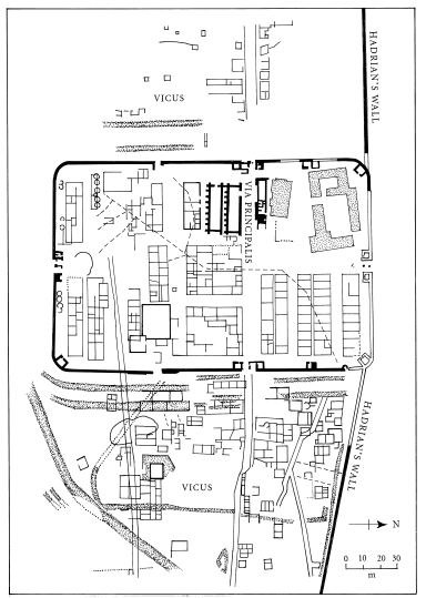
If the landscape around the Wall was not a barren waste, did the entire system collapse when the Roman troops pulled out? Indeed, did the Roman troops pull out? To answer these questions we again encounter the difficulty of recognising post-Roman or Dark Age timber buildings in the uppermost levels of a Roman stone-built site. At Wroxeter it took an inspired archaeologist, in Philip Barker, to perform this near-miracle. At Birdoswald (Latin name Banna), a large fort on the Wall in Cumbria, Phil’s equivalent has been Tony Wilmott, who directed a most remarkable series of excavations for English Heritage, mainly between 1987 and 1992.21
The interior of Birdoswald, in common with the other major garrison forts of Hadrian’s Wall, was packed full of buildings. In no way did it resemble those rather strange shell-like structures of the so-called Saxon shore. Outside the walls of the fort there was a considerable vicus, or civilian settlement. Immediately south of the fort there still is a high, partially wooded and spectacular cliff.
The fort was entered via six gateways through the walls. The main road, or via principalis, ran east-west and connected with roads in the vicus outside the walls. There were a number of important changes to the buildings within the fort in the fourth and fifth centuries. As originally laid out, it contained exercise areas, administrative and garrison buildings and granaries. One of Tony Wilmott’s most spectacular finds was the remains of a complete granary roof which collapsed some time around ad 350, leaving a vast mass - Tony describes it as ‘drifts’ - of fallen stone roof tiles lying on the flagstone floor where the grain had once been stored. The fact that the fort’s large granaries were abandoned in the mid-fourth century and never rebuilt suggests that the garrison was then supplied by local farmers, so that large quantities of grain no longer needed to be stored. It also suggests that the military contract supply system was beginning to encounter problems - of which the most likely was a shortage of money, itself the result of a failure to collect the ever-increasing Late Roman taxes.
There is some evidence that one building at Birdoswald may have been used as a church in the late fourth century, something for which there is much stronger evidence at two other forts on the Wall, at Housesteads and Vindolanda. The fort was improved after the Great Barbarian Conspiracy of ad 367, work that involved the building of a new barrack block and rebuilding parts of the main wall. By then
The main features around the Hadrian’s Wall fort of Birdoswald, Cumbria. The features plotted here were revealed by means of a geophysical survey. Note the presence of a double ditch outside the fort walls. 202 • BRITAIN A.D.
several buildings of the fort had fallen into disuse, and their stone was ‘robbed’ for the new work.
The Birdoswald excavations are best known for the discovery of two distinct phases of post-Roman timber buildings, immediately south of the via principalis, close to the main western gateway. The first was in effect a rebuilding in timber of the northerly granary - but as a hall, not as a granary. The switch from granary to domestic structure was indicated by the discovery of two hearths within the timber building. This building was rebuilt twice, and the excavators found a number of high-status objects, including a dark-green glass ring, a worn silver coin of Theodosius (388-395) and two brooches of a type that we believe may have been current in the early fifth century.
The second-phase building was also a hall, but this time wider and built of massive posts. It was a large and imposing building, measuring 23 X 6.8 metres, and it was placed so that anyone entering by the main west gateway would have seen it immediately. Even today one can appreciate the care with which it was positioned. It was patently intended to impress.
Dating the two phases of timber buildings is very difficult, because there are few reliably dateable artefacts of this period in Britain, and none at Birdoswald, apart from the silver coin of Theodosius. Taking the latest date of that coin (ad 395) as the notional start date for the first-phase timber structure and its rebuilding, Tony Wilmott has estimated that the two phases of timber building probably ended some time around ad 520.
Were the soldiers occupying Birdoswald in the fifth century so very different from their (true) Roman predecessors? Tony Wilmott is clear about this: ‘I would argue that the only change in the early fifth century was that the troops of the fort were no longer paid or supplied by central authority.’ Instead, the area around the fort, ‘from which supplies had been drawn as part of the Roman tax system, continued to sustain the fort in return for the assurance of protection in troubled times’.22 In effect, protection had been privatised, with the Roman commander of the fort being replaced by a minor Dark Age king. As time passed maybe some of the Romanitas rubbed off, and the ruler and his soldiers became more like a warlord and his warriors. If one is looking for a job description for an early-fifth-century Arthur-like

A reconstruction of the main hall and service buildings of the second phase of post-Roman settlement at Birdoswald fort, Cumbria. In the background is the west wall of the fort and the double towered gatehouse of the main western gate. The principal road through the fort, the via principalis, was narrowed to accommodate the new timber hall. The stonework foundations of two Roman granary buildings are shown below and to the left of the new hall.
figure, the post-Roman commander of Birdoswald would be an almost perfect match. It is worth noting that Birdoswald was not alone in the north: we suspect that there was also fifth-century occupation south of the Wall, at Catterick and Corbridge, both, as Tony Wilmott suggests, ‘the probable centres of petty kingdoms’.
Dominic Powlesland has devoted most of his professional life to the archaeology of a single parish and the land around it. In the process he has revealed an enormous amount about the history and prehistory of Britain as a whole. I would rate his research at West Heslerton in the East Riding of Yorkshire as one of the top landscape projects in modern Europe.23
I will never forget my first visit to Dominic’s excavation at West Heslerton in the early 1980s.The wind was howling through the trees and the rain beating down on the roof of a building in which a small group of people were washing and marking finds. Looking through the incoming finds trays was a tall young man with wild hair and a vivid rainbow-coloured sweater. This was Dominic. I was struck by the fact that he had the broadest smile in archaeology.
A good field archaeologist develops a special attitude to wet or cold weather. You can’t fight it, so you might as well enjoy it. Moaning will simply make you miserable, and that will soon spread to the rest of the team. For me, the worst thing about nasty weather is that it stops me from thinking clearly.What I remember best about Dominic’s site tour is that he was wildly enthusiastic about every small pit, ditch and post-hole we encountered - and there must have been several hundred of them.
Most archaeologists require a bit of luck at some point in their career; the trick is first to recognise it, and then to turn it to one’s advantage. Dominic’s piece of good fortune was to be asked to examine some early Anglo-Saxon burials that had turned up in a sand quarry between the villages of East and West Heslerton in the autumn of 1977. He soon realised the potential of the site, and put together a research project, largely funded by English Heritage, that has been continuing ever since. There are two reasons why the West Heslerton project is so important. The first is the landscape in which it is located, and the second is the way it has been carried out by Dominic.
The Heslerton villages are located on the south side of the Vale of Pickering, which is sandwiched between the high Yorkshire Moors to the north and the gently rolling chalk hills of the Yorkshire Wolds to the south. The Vale of Pickering today resembles a flat dish with clearly defined and quite steep sides. The peaty soils in what are now flat fields were laid down when most of the area was occupied by a huge body of fresh water, some forty miles long, known to archaeologists as Lake Pickering. Lake Pickering formed at the end of the Ice Age, fourteen thousand years ago, when the River Derwent’s outflow to the sea was blocked by ‘moraine’ - material that had been dumped across its path by a glacier. The edges of the lake have produced some of the best-known prehistoric sites in Britain, including the world-famous hunter/gatherer settlement of Star Carr.24
Over time, as peats grew and river-borne silts accumulated, Lake Pickering became a series of smaller lakes and marshes. The distinction between the peaty soils that were once wetland, and the drier sands and gravels around the edges of the now extinct lake, can clearly be seen from the air. Around the edges of the peats the familiar ‘cropmarks’ that we encountered at Maxey - the traces of ancient activity left in growing crops - are sometimes visible, but they are not always as distinct as one might wish. This is actually a good sign, because those places where the cropmarks vanish are in fact archaeologically more important. The reason for this is simple: the marks are not visible from the air because the crop plants’ roots cannot reach down that far. And the reason they cannot do this is that they are prevented from doing so by layers of windblown sand. The sandy soils around West Heslerton are easily disturbed by the wind, and when they build up on the surface they preserve everything that lies below them. That is one of the main reasons that the archaeology of the site is so exciting.
Dominic realised that the only way to fill in the ‘blanks’ between the areas where he had good cropmarks was by using a combination of limited excavation and large-scale geophysical survey. Geophysical survey is a means of plotting ancient archaeological features that are buried beneath the surface and may not appear on aerial photographs; it is done electronically, either by measuring the soil’s resistance to an electrical charge, or its magnetic properties, or even its ability to reflect a radar signal. It usually involves two people, one of whom moves the survey instrument over the surface of the ground, normally following a grid pattern. The second member of the team has the job of logging the results and checking the survey while it is underway. The geophysical surveys atWest Heslerton had to be carried out on a truly enormous scale if they were to produce meaningful results. Dominic knew that this would produce a vast amount of data, but happily he is capable of writing highly sophisticated computer software which is able tomanipulate graphics, such as maps, aerial photographs and the results of his massive geophysical surveys.
Dominic calls the most spectacular result of his work at West Heslerton ‘the wallpaper’. It’s a huge roll of computer printout about five metres long which we laid out on the floor of his sitting room. It was quite extraordinary, showing Neolithic and Bronze Age barrows, henges, fields and settlements; but the most remarkable thing was his so-called ‘ladder settlement’. This was established around an Iron Age trackway which ran along the sandy edge of the wetland and remained in use for about a thousand years, throughout the Roman period and into the Dark Ages. The scale of this settlement is quite astonishing, and it is mirrored by another one on the other side of the Vale of Pickering. It was called a ‘ladder settlement’ because the transverse or cross-cutting ditches of a succession of fields, farms and yards resemble a crazy string or rope ladder that follows a sinuous path along the Vale, more or less on the line adopted today by the A64, York to Scarborough road.
The ladder settlement, which has so far been traced for a distance of about nine miles, consisted of large farmsteads, each of which possessed its own cemetery, every 250 metres. During the Iron Age, field systems developed on the up-slope or ‘dry’ side of the ladder settlement, but that does not mean that the wetter land would have been ignored, especially during the summer months when the wet meadows would have provided abundant free grazing for the sheep and goats that we know were kept there. For what it’s worth, my own sheep would eat reeds in preference to grass any day.
The ladder settlement was abandoned some time during the fifth century. At first glance it might seem that this was a direct response to the end of the Roman Empire in Britain, but Dominic Powlesland points out that the decline had begun from the mid-fourth century, and probably owed as much to broader Romano-British ‘macroeconomic’ conditions as anything else. There is also good evidence that conditions underfoot were growing wetter towards the end of the fourth century, and this also must have played an important role, given the location of the ladder settlement alongside a wetland. As we saw at Mucking, so-called sunken feature buildings of Grubenhaus type first appear in Late Roman times, when the various elements of the ladder settlement were still in use. So they cannot be considered a reliable indicator of Anglo-Saxon (or Anglian, to be more specific) mass migration, which could not possibly have been underway at this early period. The idea of stationing foederati on farms in the Vale of Pickering is of course plainly absurd.
The next stage in the story of West Heslerton is the establishment of an Anglian village and its cemetery. So for the first time we have evidence for where the people in the graveyard actually lived. In death, they tell us a great deal about the way their lives were organised. The cemetery is on the landward side of the ladder settlement, and the village is south of that, towards the chalk slope leading up to theWolds. The village was established towards the end of Roman administration, somewhere around ad 400. Had there been a gap in time between the abandonment of the ladder settlement and the establishment of the village, Dominic would have expected windblown sand to have accumulated between the last Roman and the first Anglian features; but none was present. The new settlement was actually located on top of a Roman site, but that was not a settlement. Instead it was a stone-built temple or shrine constructed after about ad 340, around a spring. The religious rites performed there seem to have taken place in the season of spring, probably in March or April. March was the start of the Roman New Year, and April was the month celebrating Ceres, the goddess of agriculture and fertility. The shrine produced over thirty thousand pieces of Roman pottery, which would suggest that it was visited by large numbers of people.
One might suppose that the new Anglian community was located close to the spring line for obvious reasons, but the shrine site seems to have been deliberately avoided throughout the life of the village, which would suggest that it was still respected in some way. The new village was laid out to cover an area of five hundred metres square. It was occupied for over four hundred years, and did not go out of use until after ad 850, by which time over 220 buildings had been built and used. The buildings consisted ofGrubenhäuser (or ‘pit dwellings’) and post-built rectangular halls. Dominic is convinced that the Grubenhäuser were specialised structures used to provide dry storage. The wooden floor was raised above the ground on low turf walls, and the large pit below provided more space for air to circulate. A thatched roof rested on a simple A-frame that was supported by posts at each end of the large pit. It was a simple and effective structure. They are found dotted around the Heslerton landscape, and are not confined to the village. If they were indeed used to store grain (among other things), this would suggest that the countryside round about was law-abiding and free from bandits.
In the past the presence of Grubenhäuser has been used to suggest the extent to which post-Roman life slipped into a state of barbarism. Not even in pre-Roman times did people actually live in holes in the ground, although their pagan Saxon descendants were supposed to have done. The rectangular houses or halls in which we know that people actually did live were often quite elaborate post-built structures that combined both British and Continental traditions. While the pre-Roman, ‘native’ British tradition was to build round houses, rectangular buildings became more common on many sites during the Roman period, as we saw at Orton Hall Farm. Dominic has estimated that the Anglian village would have had a population at any one time of about ten extended families, or some seventy-five people.
As I have mentioned, the Anglian cemetery that went with the village has a great deal to tell us about the way society in the village was organised. The cemetery was used between the end of the fourth and the middle of the seventh centuries (say ad 650), when the villagers decided to bury their dead somewhere else - possibly in the graveyard of an as-yet undiscovered church. There can be little doubt that the location for the cemetery was deliberately chosen to be near a very much older ceremonial and burial site of Late Neolithic and Bronze Age date (around 2000 bc). In Saxon times these barrows and other ceremonial sites would still have been clearly visible as earthworks. The earliest burials were cremations, and these were almost entirely restricted to within the area bounded by a prehistoric ceremonial enclosure and the external ring-ditches that surrounded Bronze Age barrows. Again, it would seem that the selection of these already ancient features for the earliest Anglian cremations was deliberate.
The arrangement of the non-cremated burials is of interest too. Dominic has convincingly shown that the cemetery grew from five separate centres, which subsequently spread out. He concludes that
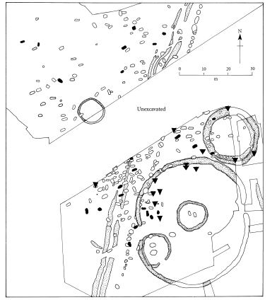
Graves in the Anglian cemetery at West Heslerton, Yorkshire. The circular features are ring-ditches that surrounded prehistoric barrows and ‘henge’-like ceremonial monuments, dating to around 2000 bc. The triangles represent Anglian cremations of about ad 450-500. Other Anglian graves (shown in black) date between ad 450 and 650.
these represent five distinct lineages or families. The arrangement of the cemetery supports the view that the post-Roman changes at West Heslerton reflect a new social and political structure. The multi-centred arrangement must reflect a well-established resident population rather than a haphazard group of incomers, most of whom, being presumably male at this early stage of the Anglo-Saxon ‘invasions’, would not have been related. Dominic Powlesland writes:
Whether we view the development of Early Anglo-Saxon England as a consequence of large-scale invasion and domination, something not adequately supported in the archaeological record, or as the emergence of a small new social and political élite whose material culture was willingly assimilated by the native population, one thing is clear: by the beginning of the sixth century the population of Eastern Yorkshire…had adopted Anglian dress and burial practices.25
Later he goes on to say:
The climatic, economic and social upheaval occurring during the declining decades of Roman Britain provided the perfect environment for the emergence of a new social order in Early Anglo-Saxon England. This need not be a new social order dominated by Anglian, Saxon or Jutish overlords. The widespread adoption of Anglo-Saxon material culture may reflect availability rather than dominance.26
The selection of a much earlier religious and ceremonial site for the Anglian cemetery again suggests a process of ‘validation’ or referring back, a phenomenon which we saw in the previous chapter, at South Cadbury. This can be a process which an incoming élite may adopt, but it only makes sense if the body of the populace understands the point of the reference. My own feeling is that it is better to view the validation process at West Heslerton as a sign that a new political and social structure had arisen following the de-Romanisation process of the late fourth and early fifth centuries. Dominic feels strongly too that there is no archaeological evidence for a powerful controlling élite, in either the cemetery or the Anglian settlement.
Reference back to earlier tradition is a recurrent theme in Anglo-Saxon northern Britain. At Old Yeavering in the hills of Northumberland a great Saxon period royal ‘palace complex’, which includes a unique timber grandstand or theatre, lies directly below the spectacular hill of Yeavering Bell, whose crown is occupied by a large prehistoric hillfort or oppidum, the ramparts of which are clearly visible from the valley below.27 Further south, in the Yorkshire Wolds, a Saxon ecclesiastical site was placed alongside the largest single standing stone in Britain, known as the Rudston Monolith. The Saxon site was also positioned precisely at the point where three Neolithic so-called cursus ceremonial monuments converged.28 In this instance it may be the Church rather than a civil authority that is claiming legitimation, but the underlying principle still holds good.
Archaeology has had its fair share of scientific techniques that have been greeted as the solution to all its problems. The most famous is radiocarbon dating. This was originally conceived in 1949, on the basis that the sun has been bombarding the earth’s outer atmosphere with radiation at a constant rate. It was soon realised, however, that ‘sun spots’ and solar flares, among other factors, could cause solar radiation to fluctuate, and this in turn affected the calculations behind radiocarbon dates. At about the same time that this was appreciated, computers were becoming cheaper and more powerful, and scientists realised that it would be possible to compensate for the changing levels of radiation mathematically - a technique known as ‘calibration’ that one can now perform at home, using a programme downloaded from the internet. After about half a century of unreliability, the accuracy of radiocarbon dating is now accepted by everyone involved in archaeology.
It’s important to keep the story of radiocarbon dating in mind when considering the new scientific techniques that are becoming available. They all have drawbacks, and they will all take some time to ‘bed in’. None will solve all our problems instantly. I will touch on the problems to do with DNA and genetic research in the next chapter, but here I want to introduce a technique that at first glance seems to be relatively uncomplicated and to have enormous archaeological potential, although it requires very expensive equipment and highly trained scientists to carry out the laboratory procedures. It’s known as stable isotope analysis.29 When I visited the lab at Durham University of Dr Paul Budd, one of the pioneers of the technique in Britain, I had to put on overshoes, white overalls and a funny hat: all impurities must be excluded from the process.
The idea behind the archaeological application of stable isotope analysis is straightforward. It is based on the realisation that tooth enamel (the shiny, hard outer coating, not the softer dentine that forms the bulk of the tooth) is laid down in childhood and does not alter subsequently. In most children the adult teeth start to develop between three and four months after birth, and finish developing at about the age of twelve. Thereafter the enamel, but not the dentine, remains inert. As the enamel is forming, it takes up the chemicals that are in the child’s environment by way of food and water. Certain elements are indicative of particular parts of the world. Levels of lead and strontium, for example, vary a great deal from one region to another. Oxygen is rather more complex: two of its isotopes, 16O and 18O, vary in response to climatic, geographical and meteorological conditions. So there will be a big difference, for example, in the composition of the stable oxygen isotopes found in tooth enamels that formed in Britain, with its warm, maritime climate, and the Alps, where conditions are more Continental.
I chose that example because this is precisely how we have come to believe that the rich Early Bronze Age burial close by Stonehenge known as the ‘Amesbury archer’ grew up in central Europe.30 Stable isotope analysis does not tell us, of course, when he left central Europe and why he came to Britain: was he on a visit, or had he settled permanently in Wessex? These are archaeological questions that will need to be answered in other ways.
Paul Budd and his team looked at a selection of teeth from Anglian graves at West Heslerton. This cemetery is very early, and is likely therefore to contain the bodies of first-generation Anglian migrants. According to Myres, and others, these people would probably have been warriors from raiding parties or ‘barbarian mercenaries’. The finds from the cemetery show close parallels with material from the Anglian European heartlands, around the Baltic coastal territories of Jutland (mainly in modern Denmark). So in theory we should know what to expect from the analysis of the tooth enamel.
Twenty-four samples were taken from the cemetery, and eight from prehistoric burials (of Early Bronze and Iron Age date). After analysis it was found, to nobody’s great surprise, that the eight prehistoric people all came from the East Yorkshire area. Of the twenty-four samples from the Anglian cemetery, four most probably came from Scandinavia, possibly somewhat north of the true Anglian region; finds with parallels further north are known atWest Heslerton, so that fitted the conventional model. But were the four individuals warriors?
Far from it. In fact they spanned the 250-year-long use of the cemetery, so they represent a series of events rather than a single large influx of new blood. What is particularly striking is the fact that all are female, and one is juvenile. Rather than being ‘high status’ graves, as one might expect, all four were among the poorest, in terms of grave-goods: none contained the fine brooches that are so characteristic of Anglian burials, and only one contained an artefact at all: a ‘girdle hanger’, a type of symbolic house key. Of the remaining twenty samples ten were local, but most unexpectedly the remainder came from west of the Pennines. This suggests that the infrastructure in the north of Britain was in a good state: roads were open, and people felt it was safe to travel not just in Britain, but further afield.
Maybe it is because we have tended to look at permanent structures, such as great buildings, barrows, town walls and so forth, that archaeologists - and I include prehistorians in this - have generally underestimated the extent to which the population of Britain and western Europe moved around. We know that pottery and coins moved, and we also know that styles of art and decoration spread across Europe very rapidly. But we do not then go on to say that people themselves must have moved too. Just because pre-Roman roads have left little trace, some prehistorians seem to believe that they were not used. So distribution maps of the period are always based around river systems, the majority of which were untamed and would have provided a very precarious means of ‘commercial’ transport, especially in wet winters and dry summers. The people of the time must have had roads, if only to move their livestock. From the little we know, it would appear that these roads and droveways were laid out in an informal network that went from settlement to settlement; in general there seem to have been no major trunk routes. By the same token, we know that Roman roads survived into post-Roman times, and the presence of Saxon settlements at some distance from them should not indicate, as has been suggested, that the Saxons were somehow ‘avoiding’ them, but that they possessed their own system, which had probably developed from the pre-Roman informal network.
Communication became very much better in Roman times. One striking example of this improved mobility was provided by the discovery in a well at Silchester of a memorial stone bearing an inscription in the Irish script known as Ogham. This stone dates to the Roman period, when the town was still in use, and it suggests not just that one Irish person lived there, but that there were people around who could read and understood the script. Who knows, maybe there was a local Irish community or enclave in the town.31
If West Heslerton is an example of the Anglian component of the ‘Anglo-Saxons’, its Saxon equivalent is in the Oxfordshire Thames Valley, in an area that has long been known as a region of Early Saxon settlement.32 The presence of such an early area of settlement so far inland has troubled many authorities on the period, but most explain it by suggesting that the early colonists sailed up the river, preferring not to disembark in London or other suitable spots further downstream, which may not have been friendly territory. Susan Hughes is currently looking at the tooth enamel from bodies in Early Saxon graves at Berinsfield, in Oxfordshire. Her results provisionally suggest that this population did not in fact come from outside, but had grown up locally.33 If this does reflect the ethnic composition of the local population, we must assume that the Thames was indeed a link to the outside world of the North Sea basin. For their own reasons - which we must allow them to have - the population of the middle Thames Valley possessed Early Saxon objects, so presumably they admired the way things were done across the North Sea. Doubtless there were people in Saxony who were influenced by tastes in post-Roman Oxfordshire.
Although the evidence of stable isotope analysis seems to support my contention that Anglo-Saxon mass migrations into Britain never happened, I still think we should be careful in the way we use this new technique. Take the seemingly open-and-shut case of Berinsfield. It is quite possible that the entire population could have migrated there a generation or two previously; if that were the case, their children or grandchildren’s teeth would have formed locally. I would prefer to use stable isotope analysis as just one approach to the problems associated with proving or disproving mass migrations, or ‘folk movements’, as they are sometimes less contentiously labelled. We must look at all the strands of evidence together. I am aware that I have chosen to set the literary accounts to one side, but I have done this to redress a historical imbalance.
My final case study is also in the heart of Anglo-Saxon eastern England. This time we are further south, within clear sight of Lincoln Cathedral, one of the greatest masterpieces of medieval architecture. I do not believe that the position of the cathedral, high above the low-lying Fen-edge valley of the River Witham, happened by accident. I think its roots lie a very long way back in time indeed - maybe back to the start of the Bronze Age, over four thousand years ago.
Here I must declare a personal interest. For some time I have been working on the edges of the Fens around Peterborough, and a few years ago I was invited to be Chairman of the Witham Valley Archaeological Research Committee (WVARC). Normally such committees are tedious in the extreme, and the Chairman’s main job is to try to keep members from nodding off. They meet in dusty rooms to discuss accounts, deadlines, grants, management plans, corporate or committee structures - anything, that is, apart fromarchaeology. But so far the WVARC has been different. Yes, we have sometimes discussed money, but as we don’t yet have very much, we actually spend our time talking about the archaeology of the Witham Valley.34
That archaeology is multi-period, which I love, because it allows me to meet and cross intellectual swords with specialists and colleagues who work outside my own field of Bronze Age studies. It’s remarkable what one can learn from people like Paul Everson and David Stocker, who really know what they are talking about when it comes to the Middle Ages, or from a specialist in peat growth or Fenland flooding, finds conservation or monastic communities.
The floodplain of the Witham Valley is remarkably flat and lowlying. Even the valley sides tend to be undulations, rather than hills as most people would recognise them; until, that is, one approaches Lincoln, where the landscape becomes altogether more emphatic. The Witham Valley is in fact a lowland river valley that has become choked with a succession of deep fenland deposits. It forms a peat-filled spur which branches off the main Fenland basin northwards for some twenty-five kilometres. At its northern end it branches into two rivers, Barlings Eau and the main River Witham. It joins the great expanse of the Fens south and east of its junction with the Rivers Slea and Bain.
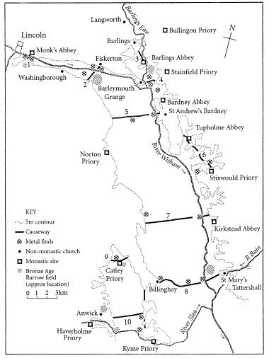
The River Witham Valley near Lincoln, showing the position of metalwork finds, the ten known causeways, Bronze Age barrow cemeteries, churches and monastic sites.
If one plots the distribution of important archaeological sites and finds in the valley, a remarkable pattern begins to emerge. We start with a series of Bronze Age barrow cemeteries which tend to be located away from the floodplain on slightly higher ground, often with a good prospect of the valley. They are regularly spaced, on both sides of the river, but with a gap at the centre which might well reflect a problem in ‘archaeological visibility’, rather than a real void or gap. The next thing to notice is the way the distribution of these cemeteries coincides with a series of ten causeways across the river. The dates when these causeways were constructed are still being established, but the one at Fiskerton (no. 2), arguably the best-known of them, was first built in the Early Iron Age, around 600 bc. There is no reason to think that the others are not of at least comparable antiquity.
There is something rather strange about these causeways, laying aside the fact that they seem in some way to be connected to ancient burial places. The Fiskerton causeway was built out of timber.35 Like all wooden structures across a wetland it required regular repair, and tree-ring research shows that the people of Iron Age Fiskerton chose to do their structural repairs in years when there was a total lunar eclipse.36 Even more exciting, it now seems that they were able to predict these events pretty reliably - which is extraordinary, as the calculations involved are by no means straightforward.What I’msaying here is that, like the barrow cemeteries, the causeways were more than mere functional landmarks. Yes, they helped people get across the floodplain, but they also served to divide the valley up into separate ‘territories’. Not even that, though, is the full explanation of what may have been going on.
Whenever one finds a prehistoric site or feature that serves as a boundary of some sort, one usually discovers that people have made offerings there. In most cases those offerings reflect rank, status or the avoidance of conflict: they might include severed human or animal heads, shields, body armour and, most common of all, swords. Swords are symbols of rank and power, but they are also symbols of conflict, or alternatively conflict that has been avoided through some symbolic act. It all depends on the contexts of where they are found. The Witham causeways have revealed a large number of metalwork finds, including Iron Age swords and what is arguably the most famous archaeological find from the county of Lincolnshire, the Witham shield, now in the British Museum. My own site at Flag Fen near Peterborough has produced Bronze and Iron Age swords and shield fragments, but the finds from the Witham continue into Roman, Saxon, Viking and medieval times. The latest depositions are of complete swords that were placed in the water in the fourteenth century, or later.
We now come to the strangest aspect of this mysterious landscape. The final coincidence concerns the siting of what is probably the largest group of early (twelfth-century) monastic settlements anywhere in Britain. One might have expected them to have clustered around the edge of the Fens, as at Ely, Peterborough, Crowland, Thorny or Ramsey, further south in Cambridgeshire. Instead we find them extending up the Witham Valley, evenly spaced, and clearly respecting the distribution of the trackways and the metalwork finds grouped around them. So, viewed as a strictly archaeological exercise, the distribution of the Early Bronze Age barrow cemeteries played a part in determining the position of a series of Early Christian foundations. This is one of the reasons I think the great cathedral of Lincoln was placed where it was. Ultimately it is making the same statement as the church alongside the Rudston Monolith: it dominates the Witham Valley just as the parish church at Rudston towers above the Neolithic standing stone. Both are making reference back to earlier times and places.
There is another aspect to the story of the swords from the River Witham. The Arthurian legends make much of what are plainly very ancient themes such as Excalibur, the Sword in the Stone, and water itself (the Lady of the Lake). I am not saying that prehistoric religious beliefs survived intact, as an organised body of theological thought and ritual tradition. That would plainly be absurd. But something must have come through from pre-Roman times, otherwise it is hard to explain the fact that no less than 70 per cent of the known areas of ritual deposition in the Witham Valley survived into medieval times.37 So rites involving the deposition of weapons in water are not just about making symbolic offerings of valuable objects. They also reflect the significance of the places where those offerings were made; that surely indicates more than a faint folk memory of some long-lost superstition. To me it suggests something altogether more potent, that was still important to influential people as late as the Middle Ages; these people were prepared to make substantial financial sacrifices to honour their beliefs, because many of the Witham offerings are fine items in their own right.
I cannot believe that the Witham was a unique late survival. Complete medieval, Roman, Iron and Bronze Age swords, daggers and other weapons have been dredged from many rivers in Britain, especially the Thames.38 Sadly, the precise find spots are often unknown, and the shape of the countryside around the river has also been lost, so it would be impossible to attempt a Witham-style exercise in, say, London; nonetheless the balance of probability suggests that both ancient rites and patterns of land allotment were linked, and that in many places they survived into the Middle Ages.
We saw earlier how the story of the Holy Blood came to be associated with the Holy Grail. Richard Barber suggested that Sir Thomas Malory was aware of the cult of the Holy Blood, which attracted pilgrims to Hailes Abbey, near the village where he probably lived. Surely it is not unreasonable to suggest that many of the ancient themes that we find in the Arthurian tales could have been current for much longer than was once believed, and that they found their way into the literature in ways that recall Malory’s adoption of the legend of the Holy Blood, which was already an old cult when he encountered it. Malory, Geoffrey of Monmouth and other contributors to the Arthurian tale were seeking to flavour their stories with an air of antiquity, so it would have made good sense to seek out customs that were known, or believed, to have had ancient roots. This must explain why authors as skilled as Geoffrey of Monmouth wove an elaborate myth around Caliburn, the sword which Arthur wore, and which was forged on the Isle of Avalon. It was a magical symbol of power, and not just in this world.Without realising it, they were telling us a great deal about the persistence of beliefs in their own time, and about rituals from the remote past too.