22
AUGUST 2012
IN THE PREDAWN hours of Saturday, August 25, Jim Blow hears what sounds like frozen rain drumming against his tent. The noise takes him back two years, when the last attempt to find the Duck was nearly washed away by relentless downpours. Burrowed inside his sleeping bag, Jim turns to Rob Tucker, his tent mate and fellow Coast Guard pilot: “Rob, this is where the shit hits the fan.” But at daybreak they realize that the sound was granular snow beating against the tent’s nylon sides. Clear skies are holding on the Koge Bay glacier, at least for now. But good weather is meaningless if we don’t know where to search.
After Spam on bagels for breakfast, science and safety teams head out from base camp hoping that the GPS issue has been resolved and the receivers are working properly. But by noon, Jim is smoldering: “We still can’t verify the points of interest.” He leaves camp, hiking more than a mile toward the rocks closest to the water. Ostensibly, he hopes to find scrape marks on a ridge if the Duck hit a nunatak, or pieces of the plane deposited by the flow of the glacier. He knows that the chances of success are slim to none, but it’s better than sitting idly in the dome tent, nursing coffee and aggravation.
Jaana continues her radar work, roped together with Frank and John to again sweep the best-guess locations of Essex One, Essex Two, and Points A, B, and K. Terri straps the magnetometer onto her back, its mast antenna extending like a flagpole four feet above her head, and goes with Nick and Alberto. Nick writes later, “Terri stomps back and forth across Point O, mumbling to herself about the readings and the data not saving. Basically, the instrument wasn’t calibrated, she didn’t really know how to use it, and those issues could have been resolved in camp instead of wasting our time on the glacier. Oh well, another pleasant walk out on the ice.”
Although the magnetometer’s effectiveness is suspect and the GPS coordinates remain dubious, the work continues under the theory that maybe the flags are close enough to the points of interest for the equipment to spot a large metal object embedded in the ice. Also, there’s nothing else to do. With our days on the glacier numbered, the only alternative would be to give up.
Both teams return to base camp hours later, tired and empty-handed. “I really was not seeing anything,” Terri says. “It was flatline the whole way.”
Throughout the morning, Lou’s been furiously making calls on his satellite phone, seeking answers everywhere from the Kulusuk Airport control tower to Colorado, where he reaches a geophysicist from the 2010 expedition. The call evolves into a lesson that helps Alberto to program the high-tech Trimble GPS receivers. From a separate call, Lou learns that an Air Greenland helicopter is en route with a technician to service a nearby ground station that enhances the accuracy of GPS satellites. GPS ground stations serve as fixed reference points; when they work correctly, they allow GPS receivers to pinpoint latitude and longitude coordinates within inches. It’s not clear what service the ground station needs—a reboot is one guess, a swift kick is another. But Lou thinks that the ground station might be the culprit for our problems, and when it’s fixed the GPS units will work properly.
Jim isn’t buying it. He dismisses the service visit to the GPS ground station as an unrelated coincidence. Instead he blames human error, caused by Lou and Steve’s mistaken assumption that Jaana or Bil would know how to operate the Trimbles. Because they’re unfamiliar with the devices, we’re forced to rely on the personal GPS units brought by John and two Coast Guardsmen, Rob Tucker and “Doc” Harman, which are putting out misleading readings.
By Saturday afternoon, after days of trial and lots of errors, Alberto and several others realize that the personal GPS units were programmed to the wrong setting. That setting, Jim says, “works great for the United States, but can be off by as much as four hundred to five hundred meters in southern Greenland.” He’s certain that the mistaken settings are the real reason for the misplaced flags.
The personal GPS units are reset for Greenland, and Alberto loads the Trimbles with the mission’s points of interest. Tests show that all the units—the personal devices as well as the Trimbles—now display the same readings for the same locations. Best of all, when the units are checked against the known coordinates of the base camp, it’s a perfect match.
“Mistakes happen,” Lou says. “It’s how you fix them that counts.”
On our third day on the glacier, we’re in business. Just in time, too, as relations between North South Polar and the Coast Guard have deteriorated. One exchange between the teams’ leaders outside the command tent captures the mood.
“We’re almost starting to plan the evacuation,” Jim tells Lou, “and we haven’t done much of anything.”
“What do you want me to do, Jim,” Lou asks, “just start digging random holes in the ice?”
“No, Lou,” Jim says, barely containing his anger. “I want you to dig six fucking holes where I told you to dig six fucking holes, at the points of interest.”
After more discussion, the expedition’s leaders walk off in opposite directions.
LATE THAT AFTERNOON, with a fully loaded Trimble in hand, Nick, Alberto, and I suit up to return to Essex One, Essex Two, and Points A, B, and K, to place the flags in their correct locations. Before we leave base camp, Nick and Alberto argue over whether we need to be roped together on the glacier.
“I’ve been on expeditions where the work doesn’t get done because of ‘safety’ getting in the way,” Alberto says. Nick says his wife wants him to return home alive, so we’ll use ropes. Alberto, who has a wife and three children, tells Nick that he resents the suggestion that he’s cavalier about safety or his family’s interests. He points out that repeated treks to the area where we’re headed have proved that the glacier there is stable, and we’ll be able to see the crevasses along the route. Nick holds his ground, arguing that a few minutes to rope up would be insignificant compared to the delays we’ve already faced, and the small investment of time might prevent a crisis that would doom the mission. Soon we’re roped together in a line, with me in the middle, twenty-five yards behind Alberto and twenty-five yards ahead of Nick.
The hardened snow crunches beneath our boots as we head northeast from base camp. The sky is a brilliant aquatic blue. Sunshine bounces off the ice. We hike up and down moguls and drainage channels, occasionally coming across areas as smooth as a skating rink. There’s no sign of life anywhere: no plants, no birds, no animals, no insects, just ice. Nick and Alberto don’t make small talk, so the glacier is quiet except for the wind, our footsteps, and our breathing. When we reach a seven-foot-wide ice bridge spanning a crevasse, I take two fast steps across, then silently celebrate that Nick prevailed on the safety ropes. If I fall through, I tell myself as I cross, they’ll pull me up. The bridge holds firm and we keep going.
We reach the first point of interest after twenty minutes and spend the next hour moving the orange flags, writing the date and the Trimble-supplied coordinates on each. Most of the new placements are about one hundred yards from their previous positions, far enough to have put Jaana’s initial radar sweeps out of range of the most promising anomalies. Before returning to base camp, we look across the glacier and see the flags arranged in exactly the pattern the mission map predicted.
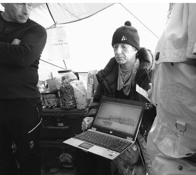
JAANA GUSTAFSSON DISPLAYS A COMPUTER IMAGE OF THE RADAR LINES SHE HAS WALKED ON THE GLACIER WITHOUT GETTING A RESPONSE SHE THINKS WOULD COME FROM THE DUCK. (MITCHELL ZUCKOFF PHOTOGRAPH.)
The correctly plotted points of interest spark a wave of enthusiasm. The feeling intensifies when Jaana runs her radar over the newly confirmed flag locations and reports possible anomalies near Points A and B. Nothing turns up at the other spots, but at least now we have something to melt toward.
That night, I sit next to Jaana in the dome as she reviews the data on her laptop. She’s quiet by nature, with a dry sense of humor. It’s obvious that she’s not excited about the readings. She shows me her computer screen and explains that although the hyperbolas near Points A and B depict something under the ice, they seem likely to have been made by empty voids or crevasses. There’s a chance they might be the Duck, but she wouldn’t bet on it. They’re just the best options she’s seen so far. I slink to my tent and crawl into my sleeping bag, the raw discomfort of the ice sheet beneath my back fitting my mood. My only consolation is that WeeGee didn’t have a chance to ask me tonight how the book ends.
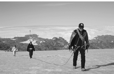
ALBERTO BEHAR LEADS THE MAGNETOMETER TEAM FROM CAMP, FOLLOWED BY TERRI LISMAN, WITH THE DEVICE STRAPPED ON HER BACK, AND W. R. “BIL” THUMA. (U.S. COAST GUARD PHOTOGRAPH BY JETTA DISCO.)
THE NEXT DAY, as everyone eats breakfast in the dome, Steve tries to pump us up: “This is probably the most critical day of our little jaunt out here, and hopefully it will be a success.” In a flurry of activity, Jaana, Nick, and John head out to Point O, while Terri, Bil, and Alberto take the magnetometer to survey the anomalies that Jaana identified around Points A and B. The rest of us fall under WeeGee’s command as members of Team Hotsy.
Compared to the expedition’s other critical pieces of equipment—the radar, the magnetometer, the Trimbles, and Alberto’s down-hole video camera—the Hotsy is a dancing bear among ballerinas. The seven-hundred-pound pressure washer is the size and shape of a basement freezer. It sports a red steel frame on twelve-inch tires; a silver, keg-sized burner filled with heating coils; a Honda engine; tanks for gas and diesel; a car battery; a muffler that doesn’t prevent it from sounding like a jet engine; and assorted valves and hoses. One hose draws water into the Hotsy, which heats it to 225 degrees Fahrenheit. The boiling water is then spit out through another hose at 3,500 pounds of pressure per square inch. In civilian life, the Hotsy’s purpose is high-powered cleaning, with enough force to tear barnacles off boat hulls and graffiti tags off buildings. Here its job is to interrogate the glacier until it surrenders its secrets.
To do its job, the Hotsy must be stationed above the site of a radar anomaly, so WeeGee can melt down to check it out. The problem is that the shortest distance between base camp and Point A is a half mile uphill, across a crevassed glacier. Ideally, we’d call for an Air Greenland helicopter to airlift the machine, but none is available. Our only option is brute force. WeeGee assesses the situation and decides that in a match between the Hotsy and us, we’d lose. So he changes the odds. He detaches the two halves of one of the extension ladders bought in Keflavík, then straps one half across the front of the Hotsy and the other half across the back. With two ladders extending parallel to one another from the body of the machine, the Hotsy bears a squinting resemblance to a certain World War II amphibious biplane.
By attaching the ladders, WeeGee has turned the Hotsy into a huge blocking sled. Nine people—four in front and five in back—can grip the ladder rungs and the Hotsy’s frame to push in unison. At the sight of this innovation/contraption, Coast Guard public affairs specialist Jetta Disco coins a slogan for whenever problems arise: “Just ask yourself, ‘What would WeeGee do?’ ”
Team Hotsy gathers along the ladders as WeeGee directs the ascent to Point A. While the rest of us assume our pushing positions bundled in heavy layers, hats, and gloves, WeeGee works gloveless and hatless, in black snow pants, a black sweater, and his trademark orange boots. Koge Bay doesn’t qualify as cold to WeeGee, who spent months carving Glacier Girl out of the ice. A consensus emerges that after so much time in Greenland, he’s now half polar bear.
We get rolling to cries of “Let’s melt some ice!” The combined North South Polar–Coast Guard effort gains steam. We’re almost trotting as we move up the steady incline. It’s not an ideal moment, but during a rest stop I tell the story of Clarence Wedel falling through a hidden crevasse seventy years ago, a few miles away. Fortunately, the glacier allows us to remain on its surface, even as we push the Hotsy across at least five bridged-over crevasses to Point A.
While the rest of us catch our breath, WeeGee fires up the engine, arranges the hoses, drills a hole to create a water source, and gets to work. Normally, the Hotsy uses a spray gun at the end of the hot-water hose. But WeeGee replaces it with a ten-foot black steel pipe. On its end he screws a pointed silver nozzle that pushes against the glacier as it melts a six-inch-diameter hole. It takes forty-five minutes or more to reach a depth of fifty to sixty feet. While WeeGee works, there’s little for the rest of us to do but wait and hope that he hits something.
With countless details to manage, Lou returns to base camp. While looking through his bags, he finds a gold ball that’s supposed to screw into the top of the flagpole. He cradles it in his hands and waits for help mounting it. Jetta tells Lou that military lore suggests that a hollow flagpole ball should contain a match and a bullet. A commander facing defeat is supposed to burn the flag to prevent its desecration and use the bullet to commit suicide.
AFTER MELTING SEVERAL holes at Point A, and instructing me in the little-known art of Hotsy glacier drilling, WeeGee drops Alberto’s camera into the holes, hoping to see signs of Duck. The camera’s images are projected onto a twenty-inch diagonal video screen Alberto has embedded in a small Pelican case, and we crowd around to watch. The images resemble a colonoscopy in an icehole, although here everyone hopes that the camera will spot a foreign object. But one hole after another contains nothing but ice.
That wouldn’t bother WeeGee—the radar can be imprecise, so maybe whatever caused the anomaly is a few feet from the holes. Under normal circumstances, he’d simply melt more holes. But WeeGee notices a disturbing pattern: water from the Hotsy pipe builds up as though stopped by a clogged drain. But when each hole reaches a certain depth, the water disappears. It’s a mystery to the rest of us, but to WeeGee it’s bad news: the holes are draining into an underground ice void. The anomaly that Jaana spotted isn’t the Duck. As she suspected, it’s a subsurface pocket of air in the glacier. WeeGee delivers the disappointing news to base camp via walkie-talkie. The other anomaly proves no different. We leave the Hotsy on the glacier and trudge back.
LATER THE SAME day, on the ice beyond our sleeping tents, WeeGee helps Jim test the magnetometer. They bury a three-foot-long steel spike in a shallow hole and, without telling Terri the location, ask her to scan the area. A beachcombing metal detector Lou brought as a backup device has already failed.
Terri walks back and forth, the magnetometer on her back, staring at the little screen at her waist. At one point the device seems to register a slight signal, but the test is a bust. Terri says a plane engine would give off a much stronger response, but Jim walks away shaking his head.
With few remaining options and little time, Jim, Lou, Jetta, Jaana, and I walk along the rocks to the spot overlooking Balchen’s X. Jim still hopes that the Duck is out there, and he again describes the flight path Pritchard might have taken. But Jaana’s radar search of Essex Three, a heavily crevassed site closest to Balchen’s X, turned up nothing, removing another once-promising point of interest. Out of earshot from the others, Jim concedes, “I’m starting to think we’re not going to come up with anything.”
Later that night, I find Lou resting his sore knees and still holding the gold flagpole ball.
“Don’t get any ideas,” I say.
“Don’t worry,” Lou says. “I’m not giving up.”
With help from the safety team, he screws the ball into place.
AT A PLANNING session that night, Lou and Jim agree that there are no more reasons to search Essex One, Essex Two, Essex Three, or Points A, B, and K. Once the six highest-priority sites, now they’re the glacial equivalent of dry wells. Tomorrow, Terri will carry the magnetometer to the lower-priority Point O, located on a slope roughly between Essex Two and Essex Three. Jaana’s radar readings there were confounded by underground crevasses, so the magnetometer visit feels more like crossing an item off a to-do list than investigating a real prospect.
Despite the loss of time from the GPS mishaps, the 2012 Duck Hunt expedition will soon have cleared seven sites, one more than required by the Coast Guard’s contract with North South Polar. It’s getting colder on the glacier, and reports from Kulusuk Airport say a storm is coming our way. We have at most two or three days before we’ll have to leave. With nothing better to do, Jim suggests that the radar team head to the farthest point yet, CRREL Point N, a mile beyond Essex Three.
Standing over a map in the command tent, Lou has an idea. He sees that the newly discovered Point N anomaly is near two other sets of coordinates, one given to him by JPAC, the Joint POW/MIA Accounting Command, and the other from the final crash report written about the PN9E in 1943. If Jaana is headed to Point N, Lou says, she should also survey the JPAC location and the 1943 point. He calls the historical point BW-1, because the crash report was written at the Army’s Bluie West One base.
Lou admits that it’s another long shot, probably the longest yet. Neither the JPAC point nor BW-1 registered as a hit on any previous aerial radar survey, which is why they weren’t named among the priority sites. Also, long-standing doubts about the historic sightings of the Duck undermine confidence in the BW-1 coordinates. Still, there’s nothing to lose but time.
MY DREAMS OF finding the Duck pretty well dashed, I head to the sleeping tents. On my way, John grabs my arm and invites me on a safety team adventure: a nighttime glacier hike. Joining us are Frank, Michelle, and Jaana, who despite all her radar work is up for more hiking.
Equipped with ice axes and roped together, we set off by moonlight toward Essex One, to find a crevasse that John noticed earlier and now wants to explore. We talk and laugh on the way, a momentary relief from what we all suspect is the expedition’s looming failure. When we reach the crevasse, we lower each other one at a time into its crooked mouth. The opening leads to a cave filled with countless enormous icicles in translucent shades of blue, a secret underground spectacle that Michelle names “the chandelier room.”
On our way back, undulating green curtains of northern lights stretch across the sky. Frank tells us to look away and then quickly look back. Each time, the shapes change, like wisps of luminescent smoke against a blue-black night. The sight gives me new appreciation for the misery of PN9E navigator Bill O’Hara. Anyone who wants to shoot the aurora borealis from the sky must know suffering beyond measure.
WITH SEARCH LOCATIONS dwindling, Jaana feels pressure to find something. Every day, upon returning to camp from a radar run, she hears a half-dozen versions of the same question: “Did you find anything?” Each time, she experiences the sadness that comes from her reply.
Before Jaana leaves with John and Frank to search the final three locations, Point N, JPAC, and BW-1, Steve aggravates her by asking if she’d be willing to run the radar not only around the three points of interest, but everywhere in between and on her way to and from the sites. Restraining her desire to tell him off, Jaana refuses, but the implied message plays on her nerves: we’re desperate, so come back with something. Trying to stay cool, she tells herself, “I can’t do more than cover as much as possible, and if I do not see anything, I do not.”
Fortified by Michelle’s breakfast egg burritos, Jaana, Frank, and John leave camp in their usual order: John out front to keep the lines straight when the radar work begins; Jaana in the middle with the gear; and Frank in the rear, watching the dragon tail—and Jaana—to keep both out of crevasses. They go first to BW-1 because it’s the closest of the three sites to camp, just under 1.4 miles away. Using John’s GPS, they find the coordinates and place a flag at the spot.
Expecting a repeat of the previous days’ fruitless work, the trio begins walking one radar line after another to the southwest of the flag. Each line extends up to five hundred feet, to be certain the area is thoroughly covered. No luck. Next they move to the northeast side of the flag to run more radar lines. Partway through the second line, Jaana calls out, “Hey, John, can you stop?”
During four days of radar work together, the radar team has scanned nearly fifteen miles of glacier, not including the miles they’ve walked together back and forth from base camp and between the points of interest. Not once in that time has Jaana stopped in the middle of a line. But staring back at her from the little screen at her waist is something unusual. The glacier at BW-1 is almost free of crevasses, a near-solid block of ice some one hundred feet deep atop bedrock. A perfect ice cube of monstrous proportions. But now, Jaana sees a flaw in the cube.
Between thirty and forty feet below where they stand, the radar shows what Jaana calls “a large, clear anomaly.” She settles herself and continues to work.
They start walking again, but when they reach the end of the radar line, Jaana surprises John and Frank again. Usually, they separate their lines by forty-five to fifty feet. This time, she asks John to lead her along a line close to the previous one. Neither John nor Frank asks why, but they know something’s up. On the second pass, the anomaly announces itself again on the screen, a boomerang-shaped message from beneath the ice. Jaana asks her partners to place a second flag between the two lines, directly over the spot where she thinks the anomaly is located.
At 10:25 on Monday morning, August 27, the expedition’s fifth day at Koge Bay, walkie-talkies set to the same frequency come alive: “Radar team to base camp,” Frank says.
“Come in, radar team,” Lou answers.
“We have a ten-meter anomaly at BW-1 position.”
“Do you like it?”
A long pause ensues.
“She likes it. Over.”
Everyone within earshot catches the significance of Frank’s last comment. It’s the first time that Jaana has been impressed enough by the sight and size of a hyperbola on her radar screen to alert base camp from the field.
Lou calls them back after warning me, “If I cry, don’t take my picture.”
He asks for Jaana, then says, “Is there anything different about this anomaly.”
Jaana: “Yes.”
Lou: “Can you please tell us what?”
Jaana knows what Lou wants to hear: it’s the Duck. But she’s a scientist, and she won’t jump to conclusions. She says calmly, “This is in clear ice, with fewer crevasses.” Jaana explains that the anomaly is large, and it’s more than thirty feet deep in what otherwise appears to be solid ice. Also, it creates a radar response that goes all the way down to the bedrock, which makes it unlikely to be a crevasse. Yet until WeeGee melts some holes and drops the camera, there’s no telling for certain what it might be.
Jaana’s restraint notwithstanding, word of the BW-1 anomaly races through base camp. Terri and the magnetometer team are told to move from Point O to BW-1 as soon as possible. Jim calls Air Greenland to request a Hotsy airlift from Point A to BW-1, a 1.3-mile distance over crevassed terrain, made worse by a large area where there’s a steep four-hundred-foot rise. The idea of the Hotsy team pushing it over the ice seems ludicrous and potentially dangerous. Lou goes as far as to say it would be impossible. Jim asks Air Greenland for fast service, but the first available helicopter won’t arrive before late afternoon tomorrow. We’ll take it, Jim says.
Lou swallows painkillers for his knees and scrambles to BW-1 to watch the magnetometer sweep. When Terri crosses the spot over the anomaly, her screen registers a reading “ten times higher than the ambient magnetic field.” In other words, something metal appears to be buried in the ice. For the first time in days of walking atop the glacier, Terri has a hit. The magnetometer shows the same reading on several passes, but not all, leaving some doubt whether the machine is working properly. Still, Lou considers it confirmation of the radar finding.
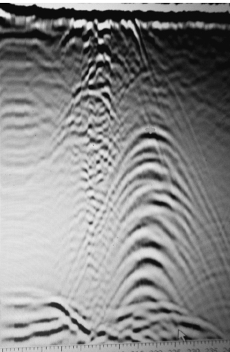
A SECTION OF THE RADAR COMPUTER SCREEN SHOWING THE TEN-METER ANOMALY AT BW-1. THE SMALL HYPERBOLAS NEAR THE SURFACE ARE ALMOST CERTAINLY A CREVASSE, WHILE THE LARGER ONES DEEP IN THE ICE RAISE HOPES AMONG THE DUCK HUNT TEAM. (MITCHELL ZUCKOFF PHOTOGRAPH.)
“I said, ‘John, Ben, Loren, give us a sign,’ ” he says. “And Terri started and stopped, started and stopped, and oh my God, it’s there.”
While Terri is at BW-1, the radar team moves to Point N and the JPAC point. They find nothing at either site. Like BW-1, Point N is almost solid ice, but with no anomalies worth noting. The JPAC site is so heavily crevassed that Jaana’s screen fills with hyperbolas, making it almost impossible to pick out an anomaly if one’s there.
After Terri’s magnetometer hit at BW-1, Lou wants the radar team to return to repeat the survey. Jaana, John, and Frank run several lines in a new direction from the BW-1 flag, with the same positive results. Point N and JPAC are forgotten; all our bets are on BW-1.
BACK AT BASE camp, geophysics experts Jaana, Terri, and Bil are upbeat but restrained, knowing that the hyperbolas might be a crevasse, and the magnetometer’s accuracy has been suspect. Still, Terri says that when she first heard about Frank’s walkie-talkie call with Jaana’s message from BW-1, she thought, If she called it out, it has to be something significant. Jaana wears a poker face, but privately admits feeling “full of energy, really happy and excited.”
In the command tent, Jim is optimistic but cautious. For one thing, if BW-1 is the crash site, he has to abandon his hard-earned theory about Balchen’s X, which is about a mile largely downhill from BW-1. Glaciers don’t move uphill, so even with glacial movement, there’s no chance that the Duck migrated from Balchen’s X to BW-1. In other words, if BW-1 is the Duck’s resting place, Balchen’s X was in the right general vicinity, but misplaced.
AS NIGHT FALLS, Lou and I agree that we might never have a better opportunity to break out Shackleton’s Scotch. If we wait and the BW-1 anomaly is a bust, we’d be drinking fine whiskey to wash away the bitter taste. If, on the other hand, the news is good, opening the historic blend will mark the start of our celebrations.
I pull the bottle’s wooden case from my duffel bag as everyone gathers in the dome. Our plastic cups held high, Lou offers a toast: “To Lieutenant John Pritchard, Radioman First Class Benjamin Bottoms, and Corporal Loren Howarth. Your families want you home. We’re here to bring you home, and may we be successful.” His cheeks flushed, his silver hair flowing from under a North South Polar baseball hat, Lou thanks us one by one for our contributions to the mission.
I’ve never seen him in finer form or the team in better spirits.
The question now is whether, as on Shackleton’s failed mission to the South Pole, the best part of our expedition will be the Scotch.